
Moby-Dick; or, The Whale is an 1851 novel by American writer Herman Melville. The book is the sailor Ishmael's narrative of the maniacal quest of Ahab, captain of the whaling ship Pequod, for vengeance against Moby Dick, the giant white sperm whale that crippled him on the ship's previous voyage. A contribution to the literature of the American Renaissance, Moby-Dick was published to mixed reviews, was a commercial failure, and was out of print at the time of the author's death in 1891. Its reputation as a "Great American Novel" was established only in the 20th century, after the 1919 centennial of its author's birth. William Faulkner said he wished he had written the book himself, and D. H. Lawrence called it "one of the strangest and most wonderful books in the world" and "the greatest book of the sea ever written". Its opening sentence, "Call me Ishmael", is among world literature's most famous.

Berkshire County is a county on the western edge of the U.S. state of Massachusetts. As of the 2020 census, the population was 129,026. Its largest city and traditional county seat is Pittsfield. The county was founded in 1761. The Berkshire Hills are centered on Berkshire County. Residents are known as Berkshirites. It exists today only as a historical geographic region, and has no county government, with the exception of the retirement board for former county workers, and certain offices such as the sheriff and registry of deeds.

Scouting in Massachusetts includes both Girl Scout and Boy Scouts of America (BSA) organizations. Both were founded in the 1910s in Massachusetts. With a vigorous history, both organizations actively serve thousands of youth in programs that suit the environment in which they live.

Pittsfield is the largest city and the county seat of Berkshire County, Massachusetts, United States. It is the principal city of the Pittsfield, Massachusetts Metropolitan Statistical Area which encompasses all of Berkshire County. Pittsfield’s population was 43,927 at the 2020 census. Although its population has declined in recent decades, Pittsfield remains the third-largest municipality in Western Massachusetts, behind only Springfield and Chicopee.

Stockbridge is a town in Berkshire County in Western Massachusetts, United States. It is part of the Pittsfield, Massachusetts, Metropolitan Statistical Area. The population was 2,018 at the 2020 census. A year-round resort area, Stockbridge is home to the Norman Rockwell Museum, the Austen Riggs Center, and Chesterwood, home and studio of sculptor Daniel Chester French.
Richford is a town in Tioga County, New York, United States. The population was 1,052 at the 2020 census. The town is named after Ezekial Rich, an early settler and benefactor of the town.
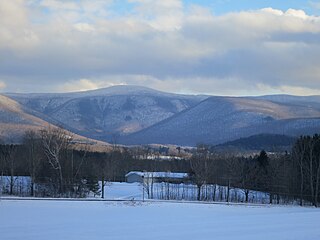
Mount Greylock is a 3,489-foot (1,063-meter) mountain located in the northwest corner of Massachusetts and is the highest point in the state. Its summit is in the western part of the town of Adams in Berkshire County. Geologically, Mount Greylock is part of the Taconic Mountains, which are not associated with the abutting Berkshire Mountains to the east. The mountain is known for its expansive views encompassing five states and the only taiga-boreal forest in the state. A seasonal automobile road climbs to the summit, topped by a 93-foot-high (28 m) lighthouse-like Massachusetts Veterans War Memorial Tower. A network of hiking trails traverses the mountain, including the Appalachian Trail. Mount Greylock State Reservation was created in 1898 as Massachusetts' first public land for the purpose of forest preservation.

Great Barrington is a town in Berkshire County, Massachusetts, United States. It is part of the Pittsfield, Massachusetts, Metropolitan Statistical Area. The population was 7,172 at the 2020 census. Both a summer resort and home to Ski Butternut, a ski resort, Great Barrington includes the villages of Van Deusenville and Housatonic.

Arrowhead, also known as the Herman Melville House, is a historic house museum in Pittsfield, Massachusetts. It was the home of American author Herman Melville during his most productive years, 1850–1863. Here, Melville wrote some of his major works: the novels Moby-Dick, Pierre, The Confidence-Man, and Israel Potter; The Piazza Tales ; and magazine stories such as "I and My Chimney".

The DeSisto School was a pair of therapeutic boarding schools founded by Michael DeSisto, DeSisto at Stockbridge School in Massachusetts and the DeSisto at Howey School in Florida. It closed in 2004 amid allegations by state authorities that the school endangered the health and safety of its students.
Tyringham Cobble is a 206-acre (83 ha) open space reservation located in Tyringham, Massachusetts on 411 m (1,348 ft) Cobble Hill in The Berkshires. It is managed by The Trustees of Reservations, a non-profit conservation organization, and is notable for its scenic views over the rural landscape of Tyringham Valley from rocky ledges and open fields. The reservation consists of the hill and surrounding agricultural and pasture land. In 2008, part of the 2,175 mile (3,500 km) Appalachian Trail was routed over the summit ledges.

The Elm–Maple–South Streets Historic District is a historic district encompassing part of the historic downtown of Stockbridge, Massachusetts. The most prominent parts of Stockbridge lie within the Main Street Historic District, which abuts this district to the north. The southern boundary of this district is the railroad tracks that run parallel to the Housatonic River. The eastern boundary of the district is Laurel Hill, a wooded park overlooking the town, and the western boundary is a terraced shelf in the plains of the river. The district includes properties on Depot, Elm, Maple, and South Streets, and Laurel Lane. Unlike Main Street, this district consists of more densely place residences, and narrower roads containing businesses just off Main Street. Its buildings were mostly constructed during the late 19th and early 20th centuries, and partially reflect Elm Street's function as an industrial part of the town. The district was added to the National Register of Historic Places in 2004.

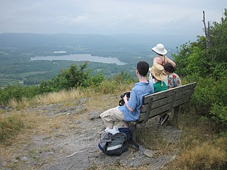
Monument Mountain is the name of a popular 503-acre (204 ha) open space reservation located in Great Barrington, Massachusetts on the southeast side of Monument Mountain. The reservation is centered on the 1,642 feet (500 m) subordinate summit of Peeskawso Peak. It is managed by The Trustees of Reservations, a non-profit conservation organization and is notable for its expansive views of the Housatonic River Valley, The Berkshires, the Taconic Mountains, and the Catskill Mountains of New York from the knife-edge summit of Peeskawso Peak. Monument Mountain, composed of erosion resistant quartzite, is of The Berkshires geology. The reservation receives more than 20,000 visitors a year. The mountain was logged for charcoal to fuel a furnace in Vandusenville at the corner of Division St and Rt 41 in Great Barrington, not the for-mentioned furnaces of Falls Village etc Remnants of the furnace can be seen if one stands on the Rt41 bridge and looks upstream on the Williams River

Stockbridge School was a progressive co-educational boarding school for adolescents near the Interlaken section of Stockbridge, Massachusetts and which operated from 1948 to 1976.
Yokun Ridge is a ridge in the Taconic Mountains in Berkshire County, Massachusetts, consisting of a well-defined series of contiguous peaks including West Stockbridge Mountain and Lenox Mountain. The name "Yokun Ridge" was invented for the area in 1971 by a land conservation and environmental advocacy organization called the Berkshire Natural Resources Council, and was accepted in 2009 by the United States Board on Geographic Names. Yokun Ridge is 9 miles (14 km) long and contains a conservation planning area called the Stockbridge-Yokun Ridge Reserve designated in 1993 by the U.S. Forest Service under its Forest Legacy Program. The ridge is notable for outdoor recreation and scenic beauty, as well as its conserved land and proximity to the tourist destinations of Lenox and Stockbridge. Yokun Ridge is located within West Stockbridge, Stockbridge, Lenox, Richmond, and Pittsfield, Massachusetts. Approximately one-third of the ridge is protected as open space reserve, municipal watershed, and wildlife sanctuary.
The Berkshire Natural Resources Council (BNRC) is a non-profit land conservation and environmental advocacy organization formed in 1967 that protects and maintains more than 50 properties and 10,000 acres (4,000 ha) of conservation restrictions around the Berkshires in western Massachusetts. The mission of the BNRC is "to protect and preserve the natural beauty and ecological integrity of the Berkshires for public benefit and enjoyment."

The Laurel Hill Association is the oldest village beautification society in the United States. Founded in 1853 in Stockbridge, Massachusetts, it has played a key role in the beautification of the town. It owns the property for Laurel Hill, near the Stockbridge town center and maintains the trail for the Ice Glen.
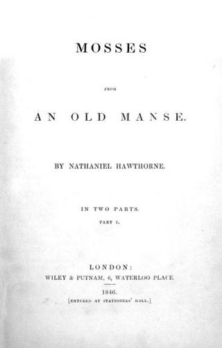
"Hawthorne and His Mosses" (1850) is an essay and critical review by Herman Melville of the short story collection Mosses from an Old Manse written by Nathaniel Hawthorne in 1846. Published pseudonymously by "a Virginian spending July in Vermont", it appeared in The Literary World magazine in two issues: August 17 and August 24, 1850. It has been called the "most famous literary manifesto of the American nineteenth century."

Gordon Hyatt is an American writer and television producer. Hyatt is most well known for his work writing and producing CBS television documentaries, but has also been involved with public broadcasting as well as various civic and public service activities.
Sarah Morewood (1823–1863) was a poet and literary figure who developed a close relationship in the 1850s with her nearest neighbor in the Berkshires, the novelist Herman Melville. In 1983 Professor Michael Rogin of the University of California, Berkeley, was the first to suggest that Morewood was a model for the character of Isabel in Melville's dark novel of romance and ambition Pierre; or, The Ambiguities (1852). Thirty-three years later biographer Michael Shelden argued in Melville in Love (2016) that Morewood influenced Melville's work not only in Pierre, but also in Moby-Dick (1851), and that for much of the 1850s the two were lovers.
