Le Roy (village), New York

Last updated

Le Roy, New York
Downtown Le Roy, NY.jpg
Downtown, looking east along Main Street (NY 5) from
Clay and Lake street (NY 19) intersection
Genesee County New York incorporated and unincorporated areas Le Roy (village) highlighted.svg
Location in Genesee County and the state of New York.
New York in United States (US48).svg
Location of New York in the United States
Coordinates: 42°58′39″N77°59′32″W / 42.97750°N 77.99222°W / 42.97750; -77.99222
CountryUnited States
State New York
County Genesee
Settled1797
Incorporated 1834
Government
  TypeVillage Hall
  MayorGreg "Porp" Rogers
Area
[1]
  Total2.69 sq mi (6.97 km2)
  Land2.69 sq mi (6.97 km2)
  Water0.00 sq mi (0.00 km2)
Highest elevation
(Water tower S of Main St. in eastern half of village)
960 ft (290 m)
Lowest elevation
(Oatka Creek on N village line)
820 ft (250 m)
Population
 (2020)
  Total4,300
  Density1,598.51/sq mi (617.09/km2)
Time zone UTC-5 (EST)
  Summer (DST) UTC-4 (EDT)
ZIP Code
14482
Area code 585
FIPS code 36-42026
GNIS feature ID0955133
Wikimedia CommonsLe Roy, New York
Website Village of Le Roy

Le Roy is a village in Genesee County, New York, United States. The population was 4,391 at the 2010 census. [2] The village lies in the center of the town of Le Roy at the intersection of State Routes 5 and 19.

Contents

History

Prior to its incorporation in 1834, the first settlements in the village were to the east of the present village site.

The village was an early center for the manufacture of patent medicines by companies such as S. C. Wells & Co. and household chemicals. Products produced in Le Roy included Mustarine, a patent mustard-plaster compound, and Rough On Rats, a rodent poison. Earliest businesses in the village are the Bank of LeRoy (founded 1834, now Bank of America) and the Gazette-News newspaper (defunct 1993). Le Roy is the birthplace of Jell-O. [3]

Le Roy holds the Oatka Festival every summer, the tradition originating in 1989. This festival includes celebration of the rich culture and history of the local area with vendors and several local businesses and restaurants participating each year.

The First Presbyterian Church of Le Roy, Keeney House, Machpelah Cemetery, Le Roy House and Union Free School, Augustus S. Tyron House, U.S. Post Office, and Marion Steam Shovel are listed on the National Register of Historic Places. [4] [5] [6]

Geography

Le Roy is located in eastern Genesee County at 42°58′32″N77°59′26″W / 42.97556°N 77.99056°W / 42.97556; -77.99056 (42.975656, -77.990792), [7] southwest of the center of the town of Elba.

According to the United States Census Bureau, the village has a total area of 2.7 sq mi (7.0 km2), of which 1.65 acres (6,678 m2) is water. [2]

Oatka Creek, dammed to create a reservoir in the village Oatka Creek Le Roy NY Aug 10.JPG
Oatka Creek, dammed to create a reservoir in the village

Oatka Creek, a tributary of the Genesee River, flows through the village.

New York State Route 19 intersects New York State Route 5 in LeRoy. NY 19 (Lake Street to the north, Clay Street to the south) leads north 8 miles (13 km) to Bergen and south 19 miles (31 km) to Warsaw. NY 5 (Main Street) leads east 7 miles (11 km) to Caledonia and west 10 miles (16 km) to Batavia, the Genesee County seat. Interstate 90, the New York State Thruway, passes north of Le Roy, with access from Exit 47 (I-490/NY 19) 4.5 miles (7.2 km) north of the village.

Demographics

Historical population
CensusPop.Note
1870 2,634
1890 2,743
1900 3,14414.6%
1910 3,77119.9%
1920 4,20311.5%
1930 4,4746.4%
1940 4,413−1.4%
1950 4,7217.0%
1960 4,662−1.2%
1970 5,1189.8%
1980 4,900−4.3%
1990 4,9741.5%
2000 4,462−10.3%
2010 4,391−1.6%
2020 4,300−2.1%
U.S. Decennial Census [8]

As of the census [9] of 2000, there were 4,462 people, 1,845 households, and 1,114 families residing in the village. The population density was 1,654.8 inhabitants per square mile (638.9/km2). There were 1,980 housing units at an average density of 734.3 per square mile (283.5/km2). The racial makeup of the village was 94.73% White, 2.47% Black or African American, 0.38% Native American, 0.56% Asian, 0.02% Pacific Islander, 0.22% from other races, and 1.61% from two or more races. Hispanic or Latino of any race were 0.92% of the population.

There were 1,845 households, out of which 29.7% had children under the age of 18 living with them, 44.1% were married couples living together, 11.5% had a female householder with no husband present, and 39.6% were non-families. 33.3% of all households were made up of individuals, and 14.5% had someone living alone who was 65 years of age or older. The average household size was 2.35 and the average family size was 3.04.

In the village, the population was spread out, with 25.0% under the age of 18, 7.3% from 18 to 24, 28.6% from 25 to 44, 21.7% from 45 to 64, and 17.4% who were 65 years of age or older. The median age was 38 years. For every 100 females, there were 87.4 males. For every 100 females age 18 and over, there were 82.0 males.

The median income for a household in the village was $33,168, and the median income for a family was $43,594. Males had a median income of $36,740 versus $21,306 for females. The per capita income for the village was $18,565. About 6.1% of families and 7.3% of the population were below the poverty line, including 7.1% of those under age 18 and 10.1% of those age 65 or over.

Notable people

Related Research Articles

<span class="mw-page-title-main">Genesee County, New York</span> County in New York, United States

Genesee County is a county in the U.S. state of New York. As of the 2020 census, the population was 58,388. Its county seat is Batavia. Its name is from Seneca word Gen-nis'-hee-yo, meaning "the Beautiful Valley". The county was created in 1802 and organized in 1803.

<span class="mw-page-title-main">Bethany, New York</span> Town in New York, United States

Bethany is a town in Genesee County, New York, United States. The population was 1,765 at the 2010 census. The town lies on the southern border of Genesee County. US Route 20 and NYS Route 63 pass through the town.

<span class="mw-page-title-main">Pavilion, New York</span> Town in New York, United States

Pavilion is a town in Genesee County, New York, United States. The population was 2,495 at the 2010 census. The town was named after a hotel in Saratoga Springs, New York, by an early resident. The town of Pavilion is in the southeastern corner of Genesee County and is southeast of the city of Batavia.

<span class="mw-page-title-main">Stafford, New York</span> Town in New York, United States

Stafford is a town in Genesee County, New York, United States. The population was 2,459 at the 2010 census. The town was named after a town of the same name in England.

<span class="mw-page-title-main">Scottsville, New York</span> Village in New York, United States

Scottsville is a village in southwestern Monroe County, New York, United States, and is in the northeastern part of the Town of Wheatland. The population was 2,001 at the 2010 census. The village is named after an early settler, Isaac Scott. Most Scottsvillians work in and around the city of Rochester—the village of Scottsville is located about a ten-minute drive from the outer limits of the city.

<span class="mw-page-title-main">Wheatland, New York</span> Town in New York, United States

Wheatland is a town in Monroe County, New York, United States. The population was 4,775 at the 2010 census. The town is home to Genesee Country Village and Museum.

<span class="mw-page-title-main">Covington, New York</span> Town in New York, United States

Covington is an incorporated town in Wyoming County, New York. The population was 1,231 at the 2010 census. The town was named after General Leonard Covington.

<span class="mw-page-title-main">Middlebury, New York</span> Town in New York, United States

Middlebury is an incorporated town in Wyoming County, New York. The population was 1,508 at the 2000 census. The town is on the north border of the county.

<span class="mw-page-title-main">Albion (village), New York</span> Village in New York, United States

Albion is a village in Orleans County, New York, United States. The population was 5,637 as of the 2020 census, down 419 from the 2010 census. The village is centrally located in the county, and is partly within the towns of both Albion and Gaines. It is the county seat of Orleans County and is about 30 miles (48 km) west/northwest of Rochester. Albion is part of the Rochester metropolitan area.

Angelica is a town in the middle of Allegany County, New York, United States. The population was 1,284 at the 2020 census. The town is named after Angelica Schuyler Church, the sister of Elizabeth Schuyler Hamilton, activist, scholar, devoted sister and mother, daughter of General Philip Schuyler, sister-in-law of Founding Father Alexander Hamilton and wife of John Barker Church. The town was named by Philip Schuyler Church, who was one of the original European settlers of the area, and the son of Angelica and John Barker Church. The village of Angelica is located within this town.

<span class="mw-page-title-main">Le Roy, New York</span> Town in New York, United States

Le Roy, or more commonly LeRoy, is a town in Genesee County, New York, United States. The population was 7,641 at the time of the 2010 census. The town is named after one of the original land owners, Herman Le Roy. The town lies on the southwestern edge of Monroe County. Within the town is a village of Le Roy. The Jell-O gelatin dessert was invented and first manufactured in Le Roy.

<span class="mw-page-title-main">Caledonia (village), New York</span> Village in New York, United States

Caledonia is a village in the town of Caledonia, Livingston County, New York, United States. The population was 2,201 at the 2010 census, out of 4,255 in the entire town. The name refers to Scotland.

<span class="mw-page-title-main">Caledonia, New York</span> Town in New York, United States

Caledonia is a town in Livingston County, New York, United States. The population was 4,255 at the 2010 census. The town contains the village of Caledonia. The town is in the northwestern part of the county and is southwest of Rochester. It is part of the Rochester metropolitan area.

Leicester is a village in the town of Leicester, Livingston County, New York, United States. The population was 468 at the 2010 census, out of 2,200 in the entire town of Leicester. The village and town are named after Leicester Phelps, an early inhabitant.

Leicester is a town in Livingston County, New York, United States. The population was 2,200 at the 2010 census. The town is named after Leicester Phelps, an early inhabitant.

Lima is a town in Livingston County, New York, United States. The population was 4,305 at the 2010 census. The town is in the northeast part of the county, south of Rochester. The village of Lima is located within the town.

Mount Morris is a town in Livingston County, New York, United States. The population was 4,465 at the 2010 census. The town and village were named after Robert Morris, a Founding Father of the United States.

<span class="mw-page-title-main">Bath (village), New York</span> Village in New York, United States

Bath is a village in Steuben County, New York, United States. The population was 5,786 at the 2010 census. Bath is the county seat of Steuben County. The community was named either for the English city of Bath, Somerset, or for Lady Laura Pulteney, 1st Countess of Bath and daughter of Sir William Pulteney, one of the original landowners.

<span class="mw-page-title-main">Warsaw (village), New York</span> Village in New York, United States

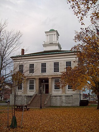
Warsaw is a village in Wyoming County, New York, United States. It is the county seat of Wyoming County and lies inside the Town of Warsaw. The village of Warsaw is near the center of the town in a valley. The population was 3,473 at the 2010 census. A branch of Genesee Community College is in Warsaw.

<span class="mw-page-title-main">Warsaw, New York</span> Town in New York, United States

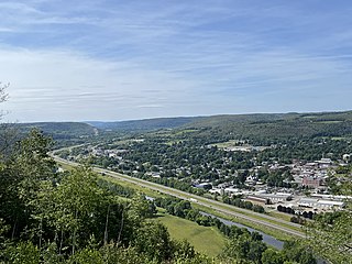
Warsaw is a town in Wyoming County, in the U.S. state of New York. The population was 5,064 at the 2010 census. It is located approximately 37 miles east southeast of Buffalo and approximately 37 miles southwest of Rochester. The town may have been named after Warsaw, Poland.

References

  1. "ArcGIS REST Services Directory". United States Census Bureau. Retrieved September 20, 2022.
  2. 1 2 "Geographic Identifiers: 2010 Demographic Profile Data (G001): Le Roy village, New York". American Factfinder. U.S. Census Bureau. Retrieved December 27, 2016.[ dead link ]
  3. "Jell-O History" Archived 2014-02-13 at the Wayback Machine , The JELL-O Gallery, Retrieved 2011-05-26.
  4. "National Register Information System". National Register of Historic Places . National Park Service. July 9, 2010.
  5. "National Register of Historic Places Listings". Weekly List of Actions Taken on Properties: 3/11/13 through 3/15/13. National Park Service. March 22, 2013.
  6. "National Register of Historic Places Listings". Weekly List of Actions Taken on Properties: 9/08/14 through 9/12/14. National Park Service. September 19, 2014.
  7. "US Gazetteer files: 2010, 2000, and 1990". United States Census Bureau. February 12, 2011. Retrieved April 23, 2011.
  8. "Census of Population and Housing". Census.gov. Retrieved June 4, 2015.
  9. "U.S. Census website". United States Census Bureau . Retrieved January 31, 2008.