Related Research Articles

Athens is a township in the United Counties of Leeds and Grenville in Eastern Ontario, Canada. It is located approximately 25 kilometres (16 mi) north of the St. Lawrence River, near Brockville, west of Addison, and about 90 kilometres (56 mi) south west of Ottawa. Formerly, it was a part of Yonge township before becoming Rear of Yonge and Escott with Athens as its own census division and finally, Athens township. The township consists of the town of Athens and a few other small communities.
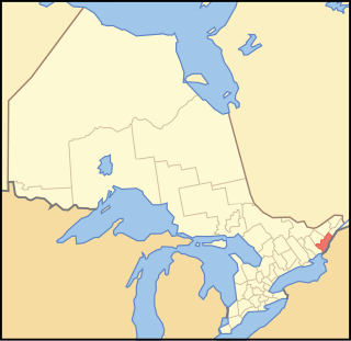
The United Counties of Leeds and Grenville, commonly known as Leeds and Grenville, is a county in Ontario, Canada, in the Eastern Ontario subregion of Southern Ontario. It fronts on the Saint Lawrence River and the international boundary between Canada and the United States, opposite of the State of New York. The county seat is Brockville. The county was formed by the union of the historical counties of Leeds and Grenville in 1850.

Elizabethtown-Kitley is a township in eastern Ontario, Canada, in the United Counties of Leeds and Grenville. Its southern border lies along the St. Lawrence River and it extends north into many rural hamlets and villages. The township was created on January 1, 2001 by the amalgamation of the former Township of Elizabethtown and Township of Kitley.

Grenville County is a former county in the Canadian province of Ontario. It fronted on the north shore of the Saint Lawrence River, between the towns of Kingston and Cornwall. The county was created in 1792, and named in honour of William Grenville, 1st Baron Grenville, who was the British Secretary of State responsible for the colonies in 1790. It consisted of five townships, which were settled primarily by United Empire Loyalists in the late 1700s after the Revolutionary War. Prior to being settled by Europeans, the area was home to many generations of native cultures. Grenville County merged with Leeds County in 1850 to create Leeds and Grenville County. The county covered an area of 272,261 acres (110,180 ha).

Leeds—Grenville—Thousand Islands and Rideau Lakes is a federal electoral district in Ontario, Canada, that has been represented in the House of Commons since 1979. Prior to the 2015 election, the riding was known as Leeds—Grenville.
Brockville was a federal electoral district in Ontario, Canada, that was represented in the House of Commons of Canada from 1867 to 1917. It was created by the British North America Act of 1867.
Leeds South was a federal electoral district in Ontario, Canada, that was represented in the House of Commons of Canada from 1867 to 1904. It was created by the British North America Act of 1867 which divided the County of Leeds into two ridings: a north riding and a south riding. The north riding was combined with the North Riding of the County of Grenville. The riding did not change its boundaries during its existence. It consisted of the Townships of North Crosby, South Crosby, Burgess South, Bastard, Leeds, Lansdowne, Escott and Yonge.
Leeds was a federal electoral district represented in the House of Commons of Canada from 1904 to 1979. It was located in the province of Ontario. This riding was first created in 1903 from parts of Leeds North and Grenville North and Leeds South ridings.
A police village was a form of municipal government that was used in the province of Ontario, Canada in the early 19th century if the finances or the population of an area did not permit the creation of a village.

The Johnstown District was a historic district in Upper Canada which existed until 1849.
Rideau Ferry is a small community in Eastern Ontario, Canada, along the Rideau Waterway. Rideau Ferry straddles a narrow stretch of water joining the Big Rideau Lake to the Lower Rideau Lake. At Rideau Ferry, the south shore of the Rideau Waterway is located within the Township of Rideau Lakes in Leeds and Grenville County, and the north shore is located within the township of Drummond/North Elmsley in Lanark County.
Rideau Lakes is a township located within Leeds and Grenville United Counties in Eastern Ontario, Canada. The township was incorporated on 1 January 1998 by amalgamating the former townships of North Crosby, South Crosby, Bastard, South Burgess and South Elmsley with the village of Newboro.

Kemptville Creek is a stream in the municipalities of North Grenville and Augusta, in the United Counties of Leeds and Grenville, in Eastern Ontario, Canada. It is in the Ottawa River drainage basin, is a right tributary of the Rideau River, and is under the auspices of the Rideau Valley Conservation Authority.

Front of Yonge is a township found in the United Counties of Leeds and Grenville in Ontario, Canada. It is the location of the Thousand Islands National Park and Brown's Bay Provincial Park, as well as a number of private campgrounds, the Jones Creek walking trail system, and the 1000 Islands Waterfront Trail’s walking/bike path which runs from just beyond the township’s eastern boundary to neighbouring towns. The predominance of the Canadian Shield produces scenic and diverse landscapes which include exposed rock formations and heavy tree cover, as well as wide fields and beaches.

Leeds and the Thousand Islands is a township in the Canadian province of Ontario, located within the United Counties of Leeds and Grenville. The township is located along the Saint Lawrence River, and extends north into rural hamlets and villages. Formerly, this township was divided into three separate townships: Leeds, Lansdowne and Escott townships; these townships amalgamated to form the current township of Leeds and the Thousand Islands.
King's Highway 29, commonly referred to as Highway 29, was a provincially maintained highway in the Canadian province of Ontario. The 52.29-kilometre (32.49 mi) route connected Highway 2 in downtown Brockville with Highway 15 south of Smiths Falls. Between those larger settlements, it provided access to the communities of Forthton, Addison, Frankville, Toledo and Newbliss.
Elections were held in Leeds and Grenville United Counties, Ontario on October 22, 2018 in conjunction with municipal elections across the province.
Grenville was an electoral district of the Legislative Assembly of the Parliament of the Province of Canada, in Canada West. Based on Grenville County, it was located on the north shore of the Saint Lawrence River, east of Lake Ontario. It was created in 1841, upon the establishment of the Province of Canada by the union of Upper Canada and Lower Canada. Grenville was represented by one member in the Legislative Assembly. It was later split into two ridings, in a redistribution.
Leeds was an electoral district of the Legislative Assembly of the Parliament of the Province of Canada, in the eastern area of Canada West. Leeds was created in 1841, upon the establishment of the Province of Canada by the union of Upper Canada and Lower Canada. It was based on Leeds County, located on the north shore of the Saint Lawrence River.
Elections were held in Leeds and Grenville United Counties, Ontario on October 24, 2022 in conjunction with municipal elections across the province.
References
- 1 2 "Leeds & Grenville GenWeb, Ontario". sites.rootsweb.com.
- ↑ Proclamation of July 16, 1792
- ↑ An act for the better division of this province , S.U.C. 1798, c. 5, s. 7-10
- ↑ 1798 Act, s. 8
- ↑ An Act to erect certain townships now forming parts of the Districts of Bathurst, Johnstown and Ottawa, into a separate District, to be called the District of Dalhousie, and for other purposes therein mentioned , S.U.C. 1838, c. 25, s. 22
- ↑ An Act for abolishing the Territorial Division of Upper-Canada into Districts, and for providing for temporary Unions of Counties for Judicial and other purposes, and for the future dissolutions of such Unions, as the increase of wealth and population may require , S.C. 12 Vic., c. 78, Sch. A, B