
Lower Saxony is a German state in northwestern Germany. It is the second-largest state by land area, with 47,614 km2 (18,384 sq mi), and fourth-largest in population among the 16 Länder federated as the Federal Republic of Germany. In rural areas, Northern Low Saxon and Saterland Frisian are still spoken, albeit in declining numbers.

Frisia is a cross-border cultural region in Northwestern Europe. Stretching along the Wadden Sea, it encompasses the north of the Netherlands and parts of northwestern Germany. Wider definitions of ‘Frisia’ may include the island of Rem and the other Danish Wadden Sea Islands. The region is traditionally inhabited by the Frisians, a West Germanic ethnic group.

Aurich is a district (Landkreis) in Lower Saxony, Germany. It is bounded by the North Sea, the districts of Wittmund and Leer, and the city of Emden.

The East Frisian Islands are a chain of islands in the North Sea, off the coast of East Frisia in Lower Saxony, Germany. The islands extend for some 90 kilometres (56 mi) from west to east between the mouths of the Ems and Jade / Weser rivers and lie about 3.5 to 10 km offshore. Between the islands and the mainland are extensive mudflats, known locally as Watten, which form part of the Wadden Sea. In front of the islands are Germany's territorial waters, which occupy a much larger area than the islands themselves. The islands, the surrounding mudflats and the territorial waters form a close ecological relationship. The island group makes up about 5% of the Lower Saxony Wadden Sea National Park.

Wittmund is a Landkreis (district) in the northwestern part of Lower Saxony, Germany. It is situated in East Frisia, on the North Sea coast. Neighboring districts are Friesland, Leer and Aurich.
Friesland is a district (Landkreis) in Lower Saxony, Germany. It is bounded by the districts of Wesermarsch, Ammerland, Leer and Wittmund, and by the North Sea. The city of Wilhelmshaven is enclosed by—but not part of—the district.

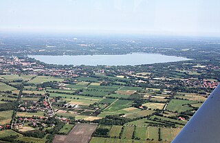
East Frisia or East Friesland is a historic region in the northwest of Lower Saxony, Germany. It is primarily located on the western half of the East Frisian peninsula, to the east of West Frisia and to the west of Landkreis Friesland.
Ammerland is a district in Lower Saxony, Germany. It is bounded by the city of Oldenburg and the districts of Oldenburg, Cloppenburg, Leer, Friesland and Wesermarsch.
Landkreis Emsland is a district in Lower Saxony, Germany named after the river Ems. It is bounded by the districts of Leer, Cloppenburg and Osnabrück, the state of North Rhine-Westphalia, the district of Bentheim in Lower Saxony, and the Netherlands.
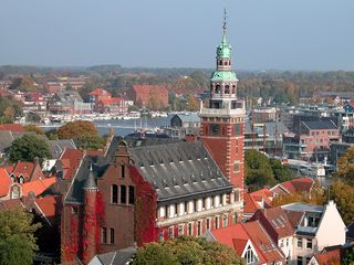
Leer is a town in the district of Leer, in the northwestern part of Lower Saxony, Germany. It is situated on the river Leda, a tributary of the river Ems, near the border with the Netherlands. With 34,958 inhabitants (2021), it is the third-largest city in East Frisia after Emden and Aurich.

Borkum is an island and a municipality in the Leer District in Lower Saxony, northwestern Germany. It is situated east of Rottumeroog and west of Juist.

Wittmund is a town and capital of the district of Wittmund, in Lower Saxony, Germany.
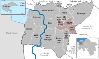
Jümme is a collective municipality (Samtgemeinde) in the district of Leer in the German state of Lower Saxony. It is named after the River Jümme which flows through all three constituent communities. It has an area of 82.34 km2 and a population of 6,421. It is situated in the region of East Frisia. Along with the Samtgemeinde of Hesel, it is one of two in the district. It was formed in the wake of local government reform in 1973. Filsum serves as the administrative centre.
Friesland is a province of the Netherlands.

Lütje Hörn is an uninhabited East Frisian Island in the North Sea. It belongs to Germany and is located approximately 3 to 4 kilometres southeast of Borkum in the East Frisian Randzelwatt. Lütje Hörn is an unincorporated area of Leer district in Lower Saxony.

The Rheiderland is a region of Germany and the Netherlands between the River Ems and the Bay of Dollart. The German part of the Rheiderland lies in East Frisia, west of the Ems. The Dutch part lies in the Dutch province of Groningen and is mostly part of Oldambt. The Rheiderland is one of the four historic regions on the mainland in the district of Leer; the others being the Overledingerland, the Moormerland and the Lengenerland.
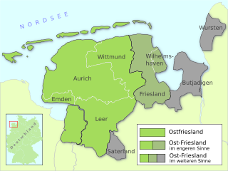
East Frisia is a collective term for all traditionally Frisian areas in Lower Saxony, Germany, which are primarily located on a peninsula between the Dollart and the Jade Bight. Along with West Frisia and North Frisia, it is one of the most commonly used subdivisions of Frisia.
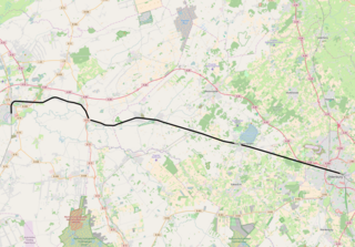
The Oldenburg–Leer railway is a 55 km (34 mi) single-track electrified main line in the north-west of the German state of Lower Saxony. It connects the Emsland line near Leer with the city of Oldenburg. Thus, it serves traffic from the direction of Hanover and Bremen to the port of Emden, the Emsland and western East Frisia, including the islands of Borkum, Juist and Norderney, which are important tourist destinations. Together with the Leer–Groningen line, it also has international significance.
The East Frisian Geest is a natural region major unit group in northwest Germany and northwestern Lower Saxony. Its character consists in the very varied juxtaposition of different landscape elements of the Northern Lowlands of which the East Frisian Geest is a part.


