Leighton Road Cutting

Last updated

Leighton Road Cutting
Site of Special Scientific Interest
Somerset UK location map.svg
Red pog.svg
Location within Somerset
Area of Search Somerset
Grid reference ST702437
Coordinates 51°11′30″N2°25′40″W / 51.19174°N 2.42781°W / 51.19174; -2.42781 Coordinates: 51°11′30″N2°25′40″W / 51.19174°N 2.42781°W / 51.19174; -2.42781
Interest Geological
Area 0.6 hectares (0.0060 km2; 0.0023 sq mi)
Notification 1984 (1984)
Natural England website

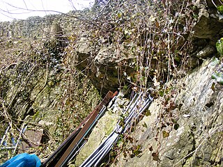
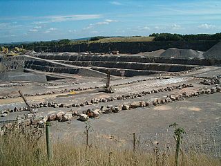
Leighton Road Cutting (grid reference ST702437 ) is a 0.6 hectare geological Site of Special Scientific Interest between East Cranmore and Cloford in Somerset, notified in 1984. It is a Geological Conservation Review site

Ordnance Survey National Grid System of geographic grid references used in Great Britain

The Ordnance Survey National Grid reference system is a system of geographic grid references used in Great Britain, distinct from latitude and longitude. It is often called British National Grid (BNG).

Hectare metric unit of area

The hectare is an SI accepted metric system unit of area equal to a square with 100-metre sides, or 10,000 m2, and is primarily used in the measurement of land. There are 100 hectares in one square kilometre. An acre is about 0.405 hectare and one hectare contains about 2.47 acres.

Somerset County of England

Somerset is a county in South West England which borders Gloucestershire and Bristol to the north, Wiltshire to the east, Dorset to the south-east and Devon to the south-west. It is bounded to the north and west by the Severn Estuary and the Bristol Channel, its coastline facing southeastern Wales. Its traditional border with Gloucestershire is the River Avon. Somerset's county town is Taunton.

Leighton Road Cutting provides exposure of a series of early Jurassic limestones, of Lower Lias age, which are the only known outcrops of these particular rocks to occur in a normal horizontally-bedded sequence in the Mendips. The discovery of the Leighton Road Cutting sections enabled geologists to understand how the fissure infills seen widely throughout the Mendips had been formed.

The Jurassic period was a geologic period and system that spanned 56 million years from the end of the Triassic Period 201.3 million years ago (Mya) to the beginning of the Cretaceous Period 145 Mya. The Jurassic constitutes the middle period of the Mesozoic Era, also known as the Age of Reptiles. The start of the period was marked by the major Triassic–Jurassic extinction event. Two other extinction events occurred during the period: the Pliensbachian-Toarcian extinction in the Early Jurassic, and the Tithonian event at the end; however, neither event ranks among the "Big Five" mass extinctions.

Mendip Hills range of limestone hills to the south of Bristol and Bath in Somerset, England

The Mendip Hills is a range of limestone hills to the south of Bristol and Bath in Somerset, England. Running east to west between Weston-super-Mare and Frome, the hills overlook the Somerset Levels to the south and the Chew Valley and other tributaries of the Avon to the north. The hills give their name to the local government district of Mendip, which administers most of the area. The higher, western part of the hills, covering 198 km2 (76 sq mi) has been designated an Area of Outstanding Natural Beauty (AONB), which gives it a level of protection comparable to a national park.

Sources

Related Research Articles

Lulsgate Plateau is the name given to the Carboniferous Limestone hills which form a northern outlier of the Mendip Hills, southwest of Bristol, England, approximately 600 feet (180 m) above sea level, which has been occupied since prehistoric times.

Banwell Ochre Caves

Banwell Ochre Caves are a 12.46-hectare geological Site of Special Scientific Interest near the village of Banwell, North Somerset, notified in 1983.

Compton Martin Ochre Mine mine in the United Kingdom

Compton Martin Ochre Mine is a 0.85 hectare geological and biological Site of Special Scientific Interest located on the north side of the Mendip Hills, immediately south west of Compton Martin village, Somerset, notified in 1988.

Dundry Main Road South Quarry

Dundry Main Road South Quarry is a 0.7 hectare geological Site of Special Scientific Interest near the village of East Dundry, North Somerset, notified in 1974.

Emborough Quarries

Emborough Quarries is a 1 hectare geological Site of Special Scientific Interest at Emborough in the Mendip Hills, Somerset, notified in 1971.

Crook Peak to Shute Shelve Hill

Crook Peak to Shute Shelve Hill is a 332.2 hectare (820.9 acre) geological and biological Site of Special Scientific Interest near the western end of the Mendip Hills, Somerset. The line of hills runs for approximately 5 kilometres (3.1 mi) from west to east and includes: Crook Peak, Compton Hill, Wavering Down, Cross Plain and Shute Shelve Hill. Most of the site is owned by the National Trust who bought 725 acres (293 ha) in 1985, and much of it has been designated as common land. It was notified as an SSSI by Natural England in 1952.

Hobbs Quarry SSSI, Shepton Mallet

Hobbs Quarry is a 0.5 hectare geological Site of Special Scientific Interest near Shepton Mallet on the Mendip Hills in Somerset, notified in 1984.

Cloford Quarry

Cloford Quarry is a 39.92-hectare (98.6-acre) geological Site of Special Scientific Interest to the south of the A361 approximately 350 metres (1,150 ft) north of the hamlet of Cloford and 1 kilometre (0.6 mi) west of Nunney on the Mendip Hills in Somerset. It was notified in 1994.

Cooks Wood Quarry

Cook's Wood Quarry also known as Holcombe Quarry is a 0.8 hectare geological Site of Special Scientific Interest near Stoke St Michael on the Mendip Hills in Somerset, notified in 1988.

Windsor Hill Quarry

Windsor Hill Quarry is a 0.8 hectare geological Site of Special Scientific Interest near Shepton Mallet on the Mendip Hills in Somerset, adjacent to the Windsor Hill Marsh biological Site of Special Scientific Interest. It was notified in 1971.

Viaduct Quarry

Viaduct Quarry is a 0.3 hectare geological Site of Special Scientific Interest near Shepton Mallet on the Mendip Hills in Somerset, notified in 1984.

Thrupe Lane Swallet is a 0.5 hectares geological Site of Special Scientific Interest in Somerset, notified in 1992. It is also a Geological Conservation Review site.

Moons Hill Quarry

Moon's Hill Quarry is a 3.42 hectare geological Site of Special Scientific Interest at Stoke St Michael in Somerset, notified in 1996 and is a Geological Conservation Review site.

Holwell Quarries

Holwell Quarries is a 1.3 hectare geological Site of Special Scientific Interest at Holwell near Nunney on the Mendip Hills in Somerset, notified in 1952.

Sandpit Hole and Bishops Lot

Sandpit Hole and Bishop's Lot is a 1.8 hectare geological Site of Special Scientific Interest near Ebbor Gorge in Somerset, notified in 1987.

Stoke St Michael village in the United Kingdom

Stoke St Michael is a village and civil parish on the Mendip Hills 4 miles (6.4 km) north east of Shepton Mallet, and 8 miles (12.9 km) west of Frome, in the Mendip district of Somerset, England.

Wanstrow village and civil parish in the Mendip district of Somerset, England

Wanstrow is a village and civil parish 6 miles (9.7 km) south west of Frome in the Mendip district of Somerset, England. The parish includes the village of Cloford.

Quarries of the Mendip Hills

The Mendip Hills, (Mendips) in northern Somerset, are the most southerly Carboniferous Limestone uplands in Britain.

The Mendip Way is an 80-kilometre (50 mi) long-distance footpath across the Mendip Hills from Weston-super-Mare to Frome. It is divided into two sections.