Leonard, Minnesota

Last updated

Leonard, Minnesota
Clearwater County Minnesota Incorporated and Unincorporated areas Leonard Highlighted.svg
Location of Leonard, Minnesota
Coordinates: 47°39′9″N95°16′9″W / 47.65250°N 95.26917°W / 47.65250; -95.26917
CountryUnited States
State Minnesota
County Clearwater
Founded1899
Incorporated June 12, 1922
Government
   Mayor Chelsea Erickson
Area
[1]
  Total0.463 sq mi (1.198 km2)
  Land0.463 sq mi (1.198 km2)
  Water0.000 sq mi (0.000 km2)
Elevation
[2]
1,453 ft (443 m)
Population
 (2020) [3]
  Total41
  Estimate 
(2022) [4]
45
  Density88.55/sq mi (34.21/km2)
Time zone UTC–6 (Central (CST))
  Summer (DST) UTC–5 (CDT)
ZIP Code
56652
Area code 218
FIPS code 27-36494
GNIS feature ID0646604 [2]
Sales tax 6.875% [5]

Leonard is a city in Clearwater County, Minnesota, United States. The population was 41 at the 2020 census. [3]

Contents

History

A post office called Leonard was established in 1899, and remained in operation until it was discontinued in 1991. [6] The city was named for Leonard French, the son of a pioneer merchant. [7]

Geography

According to the United States Census Bureau, the city has a total area of 0.463 square miles (1.20 km2), all land. [1]

Leonard is along State Highway 223 (MN 223) and County Roads 2, 10, 14, and 23.

Demographics

Historical population
CensusPop.Note
1930 109
1940 1111.8%
1950 88−20.7%
1960 70−20.5%
1970 54−22.9%
1980 50−7.4%
1990 26−48.0%
2000 2911.5%
2010 4141.4%
2020 410.0%
2022 (est.)45 [4] 9.8%
U.S. Decennial Census [8]
2020 Census [3]

2010 census

As of the 2010 census, there were 41 people, 19 households, and 12 families living in the city. The population density was 93.2 inhabitants per square mile (36.0/km2). There were 21 housing units at an average density of 47.7 per square mile (18.4/km2). The racial makeup of the city was 100.0% White.

There were 19 households, of which 31.6% had children under the age of 18 living with them, 47.4% were married couples living together, 15.8% had a female householder with no husband present, and 36.8% were non-families. 36.8% of all households were made up of individuals, and 15.8% had someone living alone who was 65 years of age or older. The average household size was 2.16 and the average family size was 2.83.

The median age in the city was 39.5 years. 24.4% of residents were under the age of 18; 7.3% were between the ages of 18 and 24; 34.1% were from 25 to 44; 14.7% were from 45 to 64; and 19.5% were 65 years of age or older. The gender makeup of the city was 48.8% male and 51.2% female.

2000 census

As of the 2000 census, there were 29 people, 17 households, and 8 families living in the city. The population density was 64.0 inhabitants per square mile (24.7/km2). There were 19 housing units at an average density of 42.0 per square mile (16.2/km2). The racial makeup of the city was 100.00% White.

There were 17 households, out of which 5.9% had children under the age of 18 living with them, 41.2% were married couples living together, and 52.9% were non-families. 52.9% of all households were made up of individuals, and 35.3% had someone living alone who was 65 years of age or older. The average household size was 1.71 and the average family size was 2.50.

In the city, the population was spread out, with 6.9% under the age of 18, 6.9% from 18 to 24, 31.0% from 25 to 44, 10.3% from 45 to 64, and 44.8% who were 65 years of age or older. The median age was 62 years. For every 100 females, there were 93.3 males. For every 100 females age 18 and over, there were 107.7 males.

The median income for a household in the city was $31,250, and the median income for a family was $43,750. Males had a median income of $0 versus $23,750 for females. The per capita income for the city was $17,005. There were no families and 7.7% of the population living below the poverty line, including no under eighteens and none of those over 64.

History

Leonard was incorporated as a village in 1922. The first head of the village council was Nels Strand and the trustees were David Payne, Carl Erickson, and Maurice Johnson. C. O. (Oscar) Lundmark was the city clerk. August Stenlund and John Carlson were justices of the peace and Henry Hagen and Ferd Isackson were the first constables. [9]

Related Research Articles

<span class="mw-page-title-main">Roosevelt Park, Michigan</span> City in Michigan, United States

Roosevelt Park is a city in Muskegon County in the U.S. state of Michigan. The population was 4,172 at the 2020 census, up from 3,831 in 2010.

<span class="mw-page-title-main">Funkley, Minnesota</span> City in Minnesota, United States

Funkley is a city in Beltrami County, Minnesota, United States. The population was 18 at the 2020 census, making the city the second-least populous incorporated place in Minnesota. It shared that distinction with Tenney until the latter dissolved in 2011.

<span class="mw-page-title-main">Georgetown, Minnesota</span> City in Minnesota, United States

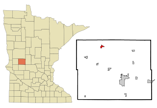
Georgetown is a city in Clay County, Minnesota, United States, along the Buffalo River near its confluence with the Red River of the North. The population was 86 at the 2020 census.

<span class="mw-page-title-main">Trommald, Minnesota</span> City in Minnesota, United States

Trommald is a city in Crow Wing County, Minnesota, United States. The population was 99 at the 2020 census. It is part of the Brainerd Micropolitan Statistical Area.

<span class="mw-page-title-main">Effie, Minnesota</span> City in Minnesota, United States

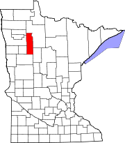
Effie( EF-ee) is a city in Itasca County, Minnesota, United States. The population was 109 at the 2020 census.

<span class="mw-page-title-main">Keewatin, Minnesota</span> City in Minnesota, United States

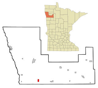
Keewatin is a city in Itasca County, Minnesota, United States. The population was 984 at the 2020 census.

<span class="mw-page-title-main">Squaw Lake, Minnesota</span> City in Minnesota, United States

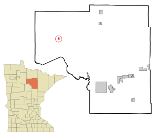
Squaw Lake is a city in Itasca County, Minnesota, United States. The population was 98 at the 2020 census.

<span class="mw-page-title-main">Sunburg, Minnesota</span> City in Minnesota, United States

Sunburg is a city in Kandiyohi County, Minnesota, United States. The population was 94 at the 2020 census.

<span class="mw-page-title-main">Borup, Minnesota</span> City in Minnesota, United States

Borup is a city in Norman County, Minnesota, United States. The population was 96 at the 2020 census.

<span class="mw-page-title-main">Erhard, Minnesota</span> City in Minnesota, United States

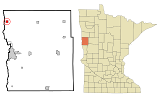
Erhard is a city in Otter Tail County, Minnesota, United States. The population was 132 at the 2020 census.

<span class="mw-page-title-main">Urbank, Minnesota</span> City in Minnesota, United States

Urbank is a city in Otter Tail County, Minnesota, United States. The population was 52 at the 2020 census.

<span class="mw-page-title-main">Beltrami, Minnesota</span> City in Minnesota, United States

Beltrami is a city in Polk County, Minnesota, United States and was named in honor of Giacomo Costantino Beltrami, an Italian exile, who traveled to the Red river and the upper Mississippi in 1823. Officially incorporated on September 11, 1901, there had been settlers in the area since 1870. It is part of the Grand Forks, ND-MN Metropolitan Statistical Area. The population was 88 at the 2020 census.

<span class="mw-page-title-main">Gully, Minnesota</span> City in Minnesota, United States

Gully is a city in Polk County, Minnesota, United States. It is part of the Grand Forks-ND-MN Metropolitan Statistical Area. The population was 59 at the 2020 census.

<span class="mw-page-title-main">Lengby, Minnesota</span> City in Minnesota, United States

Lengby is a city in Polk County, Minnesota, United States. It is part of the Grand Forks ND-MN Metropolitan Statistical Area. The population was 92 at the 2020 census.

<span class="mw-page-title-main">Mentor, Minnesota</span> City in Minnesota, United States

Mentor is a city in Polk County, Minnesota, United States. It is part of the Grand Forks-ND-MN Metropolitan Statistical Area. The population was 104 at the 2020 census. The city is near Maple Lake.

<span class="mw-page-title-main">Nielsville, Minnesota</span> City in Minnesota, United States

Nielsville is a city in Polk County, Minnesota, United States. It is part of the Grand Forks, ND-MN Metropolitan Statistical Area. The population was 78 at the 2020 census.

<span class="mw-page-title-main">Trail, Minnesota</span> City in Minnesota, United States

Trail is a city in Polk County, Minnesota, United States. It is part of the Grand Forks, ND-MN Metropolitan Statistical Area. The population was 40 at the 2020 census.

<span class="mw-page-title-main">Buhl, Minnesota</span> City in Minnesota, United States

Buhl is a city in Saint Louis County, Minnesota, United States. The population was 952 at the 2020 census.

<span class="mw-page-title-main">Iron Junction, Minnesota</span> City in Minnesota, United States

Iron Junction is a city in Saint Louis County, Minnesota, United States. The population was 110 at the 2020 census.

<span class="mw-page-title-main">Millerville, Minnesota</span> City in Minnesota, United States

Millerville is a city in Douglas County, Minnesota, United States. The population was 100 at the 2020 census.

References

  1. 1 2 "2023 U.S. Gazetteer Files". United States Census Bureau. Retrieved February 29, 2024.
  2. 1 2 U.S. Geological Survey Geographic Names Information System: Leonard, Minnesota
  3. 1 2 3 "Explore Census Data". United States Census Bureau . Retrieved February 29, 2024.
  4. 1 2 "City and Town Population Totals: 2020–2022". United States Census Bureau. February 29, 2024. Retrieved February 29, 2024.
  5. "Leonard (MN) sales tax rate" . Retrieved February 28, 2024.
  6. "Clearwater County". Jim Forte Postal History. Retrieved April 21, 2015.
  7. Upham, Warren (1920). Minnesota Geographic Names: Their Origin and Historic Significance. Minnesota Historical Society. p.  123.
  8. "Census of Population and Housing". United States Census Bureau. Retrieved June 4, 2015.
  9. Colebank, Becky (2022). 100 Years; A Centennial History of the City of Leonard. Richards Publishing Company, Gonvick. pp. 72–73.

47°39′07″N95°16′20″W / 47.65194°N 95.27222°W / 47.65194; -95.27222