Gonvick, Minnesota

Last updated

Gonvick
Clearwater County Minnesota Incorporated and Unincorporated areas Gonvick Highlighted.svg
Location of Gonvick, Minnesota
Coordinates: 47°44′13″N95°30′41″W / 47.73694°N 95.51139°W / 47.73694; -95.51139
CountryUnited States
State Minnesota
County Clearwater
Area
[1]
  Total1.31 sq mi (3.39 km2)
  Land1.31 sq mi (3.39 km2)
  Water0.00 sq mi (0.00 km2)
Elevation
1,283 ft (391 m)
Population
 (2020) [2]
  Total263
  Estimate 
(2021) [3]
267
  Density200.61/sq mi (77.48/km2)
Time zone UTC-6 (CST)
  Summer (DST) UTC-5 (CDT)
ZIP code
56644
Area code 218
FIPS code 27-24344 [4]
GNIS feature ID0644208 [5]

Gonvick is a city in Clearwater County, Minnesota, United States. The population was 263 at the 2020 census. [2] Its peak population was 375 in 1950.

Contents

History

A post office called Gonvick has been in operation since 1900. [6] The city was named for Martin O. Gonvick, a pioneer settler and native of Norway. [7]

The children in this area attend Clearbrook-Gonvick School, which is located in Clearbrook, which is approximately a five—minute commute away. The city of Gonvick had a school, which is now converted into a space for the Clearwater Life Center. It now includes a buy and sell, a florist, and numerous classes for varied activities. The Clearbrook Hornets and the Gonvick Bulldogs combined schools in 1992 as the Clearbrook-Gonvick Bears. Elementary students attended school in Gonvick while high school students were in Clearbrook until 2004, when the new school was built in Clearbrook to accommodate all the children.

Perhaps Gonvick's most famous native is Ed Widseth, an All-American tackle for the University of Minnesota and a three-time national champion from 1934 to 1936, who went on to play for the New York Giants and was inducted into the College Football Hall of Fame.

Geography

According to the United States Census Bureau, the city has a total area of 1.29 square miles (3.34 km2), all land. [8]

Gonvick is along State Highway 92 (MN 92) and County Roads 7, 8, and 9.

Demographics

Historical population
CensusPop.Note
1920 276
1930 2925.8%
1940 3178.6%
1950 37518.3%
1960 363−3.2%
1970 344−5.2%
1980 3625.2%
1990 302−16.6%
2000 294−2.6%
2010 282−4.1%
2020 263−6.7%
2021 (est.)267 [3] 1.5%
U.S. Decennial Census [9]
2020 Census [2]

2010 census

As of the census of 2010, there were 282 people, 128 households, and 79 families residing in the city. The population density was 218.6 inhabitants per square mile (84.4/km2). There were 153 housing units at an average density of 118.6 per square mile (45.8/km2). The racial makeup of the city was 94.0% White, 0.4% African American, 4.6% Native American, and 1.1% from two or more races. Hispanic or Latino of any race were 1.4% of the population.

There were 128 households, of which 29.7% had children under the age of 18 living with them, 47.7% were married couples living together, 7.8% had a female householder with no husband present, 6.3% had a male householder with no wife present, and 38.3% were non-families. 35.2% of all households were made up of individuals, and 14% had someone living alone who was 65 years of age or older. The average household size was 2.20 and the average family size was 2.82.

The median age in the city was 41.7 years. 24.5% of residents were under the age of 18; 3.5% were between the ages of 18 and 24; 25.9% were from 25 to 44; 26.2% were from 45 to 64; and 19.9% were 65 years of age or older. The gender makeup of the city was 51.8% male and 48.2% female.

2000 census

As of the census of 2000, there were 294 people, 137 households, and 79 families residing in the city. The population density was 223.9 inhabitants per square mile (86.4/km2). There were 154 housing units at an average density of 117.3 per square mile (45.3/km2). The racial makeup of the city was 91.50% White, 4.42% Native American, 2.38% from other races, and 1.70% from two or more races. Hispanic or Latino of any race were 3.40% of the population.

There were 137 households, out of which 24.1% had children under the age of 18 living with them, 46.7% were married couples living together, 9.5% had a female householder with no husband present, and 42.3% were non-families. 40.1% of all households were made up of individuals, and 25.5% had someone living alone who was 65 years of age or older. The average household size was 2.15 and the average family size was 2.90.

In the city, the population was spread out, with 21.8% under the age of 18, 8.2% from 18 to 24, 24.5% from 25 to 44, 22.4% from 45 to 64, and 23.1% who were 65 years of age or older. The median age was 42 years. For every 100 females, there were 94.7 males. For every 100 females age 18 and over, there were 91.7 males.

The median income for a household in the city was $24,722, and the median income for a family was $40,417. Males had a median income of $25,000 versus $17,917 for females. The per capita income for the city was $14,650. About 9.9% of families and 12.0% of the population were below the poverty line, including 9.6% of those under the age of eighteen and 33.3% of those 65 or over.

Related Research Articles

<span class="mw-page-title-main">Clearwater County, Minnesota</span> County in Minnesota, United States

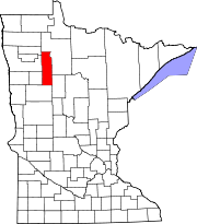
Clearwater County is a county in the northwestern part of the U.S. state of Minnesota. As of the 2020 census, the population was 8,524. Its county seat is Bagley.

<span class="mw-page-title-main">Lower Kalskag, Alaska</span> City in Alaska, United States

Lower Kalskag is a city in Bethel Census Area, Alaska, United States. It is twenty-six miles west of Aniak. At the 2010 census the population was 282, up from 267 in 2000.

<span class="mw-page-title-main">Curlew, Iowa</span> City in Iowa, United States

Curlew is a city in Palo Alto County, Iowa, United States. The population was 37 at the time of the 2020 census.

<span class="mw-page-title-main">Clearwater, Kansas</span> City in Sedgwick County, Kansas

Clearwater is a city in Sedgwick County, Kansas, United States. As of the 2020 census, the population of the city was 2,653.

Buzzle Township is a township in Beltrami County, Minnesota, United States. The population was 286 as of the 2000 census. Buzzle Township took its name from Buzzle Lake.

Jones Township is the southwesternmost township in Beltrami County, Minnesota, United States. The population was 277 as of the 2000 census. Jones Township was named for an early settler.

Lammers Township is a township in Beltrami County, Minnesota, United States. The population was 492 at the 2000 census.

O'Brien Township is a township in Beltrami County, Minnesota, United States. The population was 56 as of the 2000 census.

Roosevelt Township is a township in Beltrami County, Minnesota, United States. The population was 219 as of the 2000 census.

<span class="mw-page-title-main">Bagley, Minnesota</span> City in Minnesota, United States

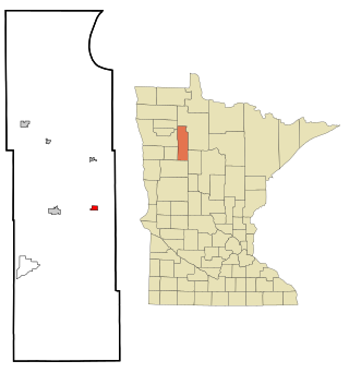
Bagley is a city in Clearwater County, Minnesota, United States. The population was 1,285 at the 2020 census. It is the county seat of Clearwater County.

<span class="mw-page-title-main">Clearbrook, Minnesota</span> City in Minnesota, United States

Clearbrook is a city in Clearwater County, Minnesota, United States. The population was 464 at the 2020 census.

Copley Township is a township in Clearwater County, Minnesota, United States. The population was 859 at the 2000 census.

<span class="mw-page-title-main">Leonard, Minnesota</span> City in Minnesota, United States

Leonard is a city in Clearwater County, Minnesota, United States. The population was 41 at the 2020 census.

Moose Creek Township is a township in Clearwater County, Minnesota, United States. The population was 227 at the 2000 census. This township took its name from Moose Creek.

<span class="mw-page-title-main">Shevlin, Minnesota</span> City in Minnesota, United States

Shevlin is a city in Clearwater County, Minnesota, United States. The population was 137 at the 2020 census.

Sinclair Township is a township in Clearwater County, Minnesota, United States. The population was 175 at the 2000 census.

Clearwater Township is a township in Wright County, Minnesota, United States. The population was 1,368 at the 2000 census.

<span class="mw-page-title-main">Clearwater, Minnesota</span> City in Minnesota, United States

Clearwater is a city in Stearns and Wright counties in the U.S. state of Minnesota. The population was 1,922 at the 2020 census. Most of the city lies within Wright County.

<span class="mw-page-title-main">Elbow Lake, Becker County, Minnesota</span> Census-designated place in Minnesota, US

Elbow Lake is a census-designated place in Becker and Clearwater counties in Minnesota, United States. Its population was 95 at the 2010 census.

<span class="mw-page-title-main">Loyal, Wisconsin</span> City in Wisconsin, United States

Loyal is a city in Clark County in the U.S. state of Wisconsin. The population was 1,261 at the 2010 census. The city is located within the Town of Loyal, though it is politically independent.

References

  1. "2020 U.S. Gazetteer Files". United States Census Bureau. Retrieved July 24, 2022.
  2. 1 2 3 "Explore Census Data". United States Census Bureau . Retrieved August 21, 2022.
  3. 1 2 "City and Town Population Totals: 2020-2021". United States Census Bureau. August 21, 2022. Retrieved August 21, 2022.
  4. "U.S. Census website". United States Census Bureau . Retrieved January 31, 2008.
  5. "US Board on Geographic Names". United States Geological Survey. October 25, 2007. Retrieved January 31, 2008.
  6. "Clearwater County". Jim Forte Postal History. Retrieved April 21, 2015.
  7. Upham, Warren (1920). Minnesota Geographic Names: Their Origin and Historic Significance. Minnesota Historical Society. p.  122.
  8. "US Gazetteer files 2010". United States Census Bureau. Archived from the original on January 25, 2012. Retrieved November 13, 2012.
  9. "Census of Population and Housing". Census.gov. Retrieved June 4, 2015.

47°44′15″N95°30′49″W / 47.73750°N 95.51361°W / 47.73750; -95.51361