Lexington Park, Maryland

Last updated

Lexington Park, Maryland
CDP
St. Mary's County Maryland Incorporated and Unincorporated areas Lexington Park Highlighted.svg
Location of Lexington Park, Maryland
Coordinates: 38°15′32″N76°27′2″W / 38.25889°N 76.45056°W / 38.25889; -76.45056
Country Flag of the United States.svg United States
State Flag of Maryland.svg  Maryland
County St. Mary's
Area
[1]
  Total6.07 sq mi (15.73 km2)
  Land6.06 sq mi (15.71 km2)
  Water0.01 sq mi (0.02 km2)
Elevation
115 ft (35 m)
Population
 (2020)
  Total13,318
  Density2,196.08/sq mi (847.86/km2)
Time zone UTC−5 (Eastern (EST))
  Summer (DST) UTC−4 (EDT)
ZIP code
20653
Area code 301/240
FIPS code 24-46725
GNIS feature ID0594792

Lexington Park is a census-designated place (CDP) in St. Mary's County, Maryland, United States, and the principal community of the Lexington Park, Maryland Micropolitan Statistical Area. The population was 11,626 at the 2010 census. [2]

Contents

History

Native American presence

Native American peoples inhabited the area as early as 3500 B.C. At the time of the arrival of the first colonists, the area was inhabited by tribes of the Piscataway Indian Nation, including the Yaocomico, Mattawoman, Pamunkey, Mattaponi and Nanjemoy. The Piscataway Nation, although fragmented, still exists today, and has small communities and cultural centers in other parts of the county. [3]

Colonial era

The area was expanded into by "planters" (mostly tobacco farmers) who moved into the area as the original settlement in St. Mary's City grew. Early plantations were first farmed by indentured and free labor, but in the late 1600s slavery began to establish itself in Maryland and the character of farming changed due to this. Wealth was concentrated in very few hands and small free farmers and laborers were pushed out or "down" (into poverty) due to competition with slave labor.

Pre-1940s community

Before the establishment of the Patuxent Naval Air Station, there were tobacco farms in what is now Lexington Park, or the base proper, and also crabbing, fishing and oyster harvesting communities in the waterfront areas. Many residents of these communities had roots going back more than 300 years in the area. Many were pushed out by eminent domain land seizures during World War Two, in order to create the new military base. Memories of this loss are still strong among older county residents. The economic boost brought by the base was welcome, but many never felt sufficiently compensated for the loss of their centuries-old homes, landholdings and fishing and farming community.

Nearby, Dashiell Hammett, noted novelist, was born on May 27, 1894.

World War Two: Advent of naval base spurs establishment of "Lexington Park"

"Lexington Park" came into being in 1943 with the establishment of the Patuxent Naval Air Station during World War II, and was named for the recently sunk USS Lexington aircraft carrier. Prior to this Lexington Park was called "Jarboesville". John Glenn, Alan Shepard, and many noted astronauts trained there. In 1977 the Governor Thomas Johnson Bridge spanning the Patuxent River linked the area to Calvert County and Solomons, Maryland.

In recent years several aerospace and high-tech companies have located in the area bringing additional jobs. Continually expanding shopping centers along Maryland Route 235 ("Three Notch Road") and Great Mills Road have many department stores.

Economy

Town

Lexington Park in seaside St. Mary's County is one of the nation's fastest-growing "micropolitan" areas, expanding by 14.6 percent since 2000, largely on the strength of military growth. The county population has surpassed 100,000 in 2010. In addition, Southern Maryland is the fast-growing area in the state, and a very desirable bedroom community for people who work in the District of Columbia, but unlike neighboring Charles and Calvert counties, many in St. Mary's County both work and live in the county.

Base

The Patuxent River Naval Air Station, which is based in Lexington Park, employs about 20,000 people, driving about 75 percent of the economy in St. Mary's County and providing roughly $3 billion to the state economy.

Civilian home prices

The average price of a home in St. Mary's County in 2014 is $252,100, compared with $337,501 in 2007, and about $200,000 in 2003. The area is surrounded by farmland and has a countryside charm with a historical appeal. In addition, there are many high tech jobs.

Area schools

Elementary and Secondary schools

Lexington Park's public schools are part of the St. Mary's County Public Schools. The schools in town include Town Creek Elementary, Greenview Knolls Elementary, Lexington Park Elementary, George Washington Carver Elementary, Esperanza Middle, and Spring Ridge Middle. Great Mills High, Chesapeake Public Charter, and Fairlead Academy are also close by in neighboring Great Mills.

Higher education

St. Mary's College of Maryland

St. Mary's College of Maryland is located seven miles south of Lexington Park and is one of only two public honors colleges in the nation.

It is ranked "5th in the nation" under the "public colleges" category by U.S. News & World Report.

It is also ranked "4th in the nation" under the category of "Best schools for veterans" by U.S. News & World Report.

College of Southern Maryland

The College of Southern Maryland, a community college, offers classes in and near the area.

Merchant Marine academy

The Paul Hall Center for Maritime Studies (a merchant marine academy) is only about 20 minutes away.

Notable historic sites

Archeological sites

Mattapany-Sewall Archeological Site was listed on the National Register of Historic Places in 1985. [4]

Other archeological research is done periodically on parts of the naval base (and its adjacent waters), focusing on Civil War, War of 1812 and colonial research.

United States Colored Troops Memorial Statue

The United States Colored Troops Memorial Statue is located in Lexington Park. It is a nationally recognized memorial to the more than 700 African-American soldiers and sailors from St. Mary's County who served in the Union forces during the Civil War. The memorial also includes an educational display. Special celebrations are also held there each year.

The mission of the site is to welcome people of all backgrounds, to honor those who served and to tell their story. The memorial is located in John G. Lancaster Park on 21550 Willows Road.

St. Richards Manor

St. Richard's Manor was listed on the National Register of Historic Places in 1985. [4]

Historic St. Mary's City

Historic St. Mary's City, seven miles south of Lexington Park, is the site of the founding of the Maryland colony as well as being recognized as the birthplace of religious freedom in America. It is now a reconstructed colonial town, a museum complex, and a center for living history. It also features the Maryland Dove, a full-sized working replica of the sailing ship that bore the first colonists to the new Maryland colony.

The complex shows what colonial life was like in what is now Lexington Park as well as both areas were originally part of the same settlement.

Geography

Lexington Park is located at 38°15′32″N76°27′2″W / 38.25889°N 76.45056°W / 38.25889; -76.45056 (38.258906, 76.450592). [5]

According to the United States Census Bureau, the CDP has a total area of 8.1 square miles (21 km2), of which 8.0 square miles (21 km2) is land and 0.1 square miles (0.26 km2) (1.24%) is water.

Climate

Lexington Park has a humid subtropical climate under the Köppen climate classification, with hot, humid summers and mild winters.

Climate data for Lexington Park, Maryland
MonthJanFebMarAprMayJunJulAugSepOctNovDecYear
Record high °F (°C)82
(28)
81
(27)
88
(31)
93
(34)
100
(38)
102
(39)
104
(40)
103
(39)
99
(37)
93
(34)
85
(29)
81
(27)
104
(40)
Mean daily maximum °F (°C)44.3
(6.8)
46.9
(8.3)
54.9
(12.7)
65.3
(18.5)
74.2
(23.4)
82.8
(28.2)
86.9
(30.5)
85.0
(29.4)
78.8
(26.0)
68.3
(20.2)
58.7
(14.8)
48.4
(9.1)
66.2
(18.0)
Daily mean °F (°C)36.1
(2.3)
38.2
(3.4)
45.6
(7.6)
55.4
(13.0)
64.7
(18.2)
73.7
(23.2)
78.1
(25.6)
76.6
(24.8)
70.1
(21.2)
59.2
(15.1)
49.7
(9.8)
40.1
(4.5)
57.3
(14.1)
Mean daily minimum °F (°C)28.0
(−2.2)
29.5
(−1.4)
36.2
(2.3)
45.5
(7.5)
55.2
(12.9)
64.7
(18.2)
69.4
(20.8)
68.2
(20.1)
61.5
(16.4)
50.0
(10.0)
40.7
(4.8)
31.7
(−0.2)
48.4
(9.1)
Record low °F (°C)−3
(−19)
4
(−16)
10
(−12)
26
(−3)
36
(2)
44
(7)
54
(12)
52
(11)
44
(7)
30
(−1)
16
(−9)
6
(−14)
−3
(−19)
Average precipitation inches (mm)3.32
(84)
2.94
(75)
4.61
(117)
3.85
(98)
3.80
(97)
4.31
(109)
4.59
(117)
4.35
(110)
4.55
(116)
3.34
(85)
3.28
(83)
3.71
(94)
46.65
(1,185)
Source: [6]

Demographics

Historical population
CensusPop.Note
2020 13,317
U.S. Decennial Census [7]

As of the census [8] of 2000, there were 11,021 people, 3,923 households, and 2,459 families residing in the CDP. The population density was 1,378.9 inhabitants per square mile (532.4/km2). There were 4,630 housing units at an average density of 579.3 per square mile (223.7/km2). The racial makeup of the CDP was 59.99% White, 30.00% African American, 0.38% Native American, 4.22% Asian, 0.12% Pacific Islander, 1.81% from other races, and 3.48% from two or more races. Hispanic or Latino of any race were 4.78% of the population.

There were 3,923 households, out of which 41.8% had children under the age of 18 living with them, 43.9% were married couples living together, 14.7% had a female householder with no husband present, and 37.3% were non-families. 29.5% of all households were made up of individuals, and 2.1% had someone living alone who was 65 years of age or older. The average household size was 2.65 and the average family size was 3.34.

In the CDP, the population was spread out, with 31.5% under the age of 18, 14.0% from 18 to 24, 39.3% from 25 to 44, 12.2% from 45 to 64, and 3.1% who were 65 years of age or older. The median age was 27 years. For every 100 females, there were 114.5 males. For every 100 females age 18 and over, there were 120.5 males.

The median income for a household in the CDP was $39,214, and the median income for a family was $42,095. Males had a median income of $30,762 versus $24,155 for females. The per capita income for the CDP was $17,605. About 9.9% of families and 11.9% of the population were below the poverty line, including 14.4% of those under age 18 and 10.6% of those age 65 or over.

Related Research Articles

<span class="mw-page-title-main">St. Mary's County, Maryland</span> County in Maryland, United States

St. Mary's County, established in 1637, is a county located in the U.S. state of Maryland. As of the 2020 census, the population was 113,777. Its county seat is Leonardtown. The name is in honor of Mary, the mother of Jesus. St. Mary's County comprises the California-Lexington Park, Maryland Metropolitan Statistical Area, which also is included in the Washington-Baltimore-Arlington, DC-MD-VA-WV-PA Combined Statistical Area. It is part of the Southern Maryland region. The county was the home to the first Maryland Colony, and the first capital of the Colony of Maryland. Settled by English Catholics, it is considered to be the birthplace of religious freedom in North America, at a time when the British colonies were settled primarily by Protestants. The county is home to the Patuxent River Naval Air Station and St. Mary's College of Maryland. Traditionally, St. Mary's County has been known for its unique and historic culture of Chesapeake Bay tidewater farming, fishing, and crabbing communities. But with the advent of the military bases, growth of an extensive defense contractor presence, and the growth of St. Mary's College of Maryland, as well as increasing numbers of long-distance Washington, D.C. commuters, it has been undergoing a decades-long transformation which has seen the county's population double since 1970.

<span class="mw-page-title-main">Brooklyn Park, Maryland</span> Census-designated place in Maryland, United States

Brooklyn Park is a census-designated place (CDP) in Anne Arundel County, Maryland, United States. The population was 14,373 at the 2010 census.

<span class="mw-page-title-main">Odenton, Maryland</span> Census-designated place in Maryland, U.S.

Odenton is a census-designated place (CDP) in Anne Arundel County, Maryland, United States, located approximately 10–20 minutes from the state capital, Annapolis. The population was 37,132 at the 2010 census, up from 20,534 at the 2000 census. The town's population growth rate of 80.8% between 2000 and 2010 was the greatest of any town in western Anne Arundel County. Odenton is located west of Annapolis, south of Baltimore, and northeast of Washington.

<span class="mw-page-title-main">Pasadena, Maryland</span> Census-designated place in Maryland, United States

Pasadena is a census-designated place (CDP) in Anne Arundel County, Maryland, United States. The population was 24,287 at the 2010 census.

<span class="mw-page-title-main">Parkville, Maryland</span> Census-designated place in Maryland, United States

Parkville is an unincorporated community and census-designated place in Baltimore County, Maryland, United States. As of the 2010 census, the population was 30,734.

<span class="mw-page-title-main">Lusby, Maryland</span> Census-designated place in Maryland, United States

Lusby is an unincorporated community and census-designated place (CDP) in Calvert County, Maryland, United States. The population of the CDP was 1,835 at the 2010 census. Residents of the Chesapeake Ranch Estates and Drum Point communities also use the Lusby ZIP code designation.

<span class="mw-page-title-main">Prince Frederick, Maryland</span> Census-designated place in Maryland, United States

Prince Frederick is an unincorporated community and census-designated place (CDP) in Calvert County, Maryland, United States. As of the 2020 census, the population of Prince Frederick was 3,226, up from 2,538 in 2010. It is the county seat of Calvert County.

<span class="mw-page-title-main">Solomons, Maryland</span> Census-designated place in Maryland, United States

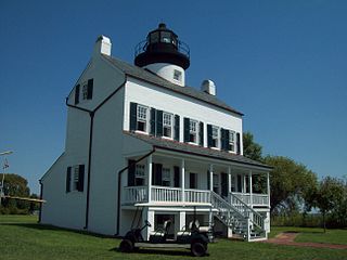
Solomons, also known as Solomons Island, is an unincorporated community and census-designated place (CDP) in Calvert County, Maryland, United States. The population was 2,368 at the 2010 census, up from 1,536 in 2000. Solomons is a popular weekend destination spot in the Baltimore–Washington metropolitan area.

<span class="mw-page-title-main">St. Leonard, Maryland</span> Census-designated place in Maryland

St. Leonard is a census-designated place (CDP) in Calvert County, Maryland, United States. The population was 742 at the 2010 census. Residents of the Calvert Beach and Long Beach communities also use the St. Leonard ZIP code designation.

<span class="mw-page-title-main">Adelphi, Maryland</span> Census-designated place in Maryland

Adelphi is an unincorporated area and census-designated place in Prince George's County, Maryland, United States. Per the 2020 Census, the population was 16,823. Adelphi includes the following subdivisions; Adelphi, Adelphi Park, Adelphi Hills, Adelphi Terrace, Adelphi Village, Buck Lodge, Chatham, Cool Spring Terrace, Hillandale Forest, Holly Hill Manor, Knollwood, Lewisdale, and White Oak Manor.

<span class="mw-page-title-main">Coral Hills, Maryland</span> Census-designated place in Maryland

Coral Hills is an unincorporated area and census-designated place (CDP) in Prince George's County, Maryland, United States. As of the 2020 census, the population was 9,997.

<span class="mw-page-title-main">Eagle Harbor, Maryland</span> Town in Maryland, United States

Eagle Harbor is an incorporated town in the far southeast corner of Prince George's County, Maryland, United States, and near the rural community of Aquasco that is known as a historic African American community founded in 1925. Per the 2020 census, the population was 67. The Chalk Point Generating Station, owned by NRG Energy, which was sold to Mirant by the Potomac Electric Power Company (PEPCO) in 2000, is located adjacent to the town.

<span class="mw-page-title-main">Greater Upper Marlboro, Maryland</span> Unincorporated area in Maryland

Greater Upper Marlboro is an area of Prince George's County, Maryland, United States, that completely surrounds Upper Marlboro, the county seat. It was formerly a census-designated place (CDP), with a population of 18,720 at the 2000 census. However, the 2010 census divided the area into several smaller CDPs, including portions of Marlboro Meadows, Brock Hall, Marlboro Village, Queenland, and Croom.

<span class="mw-page-title-main">Marlton, Maryland</span> Census-designated place in Maryland

Marlton is an unincorporated area and census-designated place (CDP) in Prince George's County, Maryland, United States. The population was 9,802 at the 2020 census. The Marlton housing development, at first briefly called "Brandywine Country", grew up along U.S. Route 301 in the 1970s, and is part of the greater Upper Marlboro community. Originally made up of only single-family homes, more recently townhouses have been added.

<span class="mw-page-title-main">Rosaryville, Maryland</span> Census-designated place in Maryland, US

Rosaryville is an unincorporated area and census-designated place (CDP) in Prince George's County, Maryland, United States, located south of Cinton and Upper Marlboro beside U.S. Route 301. Per the 2020 census, the population was 11,548. including housing developments and rural open space. It was named for a local Roman Catholic church. Close to Rosaryville are the Marlton housing development, Maryland Veterans Cemetery, the Southern Maryland Farmers Market, and Rosaryville State Park.

<span class="mw-page-title-main">Woodlawn, Prince George's County, Maryland</span> Census-designated place in Maryland

Woodlawn is an unincorporated area and census-designated place (CDP) in Prince George's County, Maryland, United States. As of the 2020 census it had a population of 7,541.

<span class="mw-page-title-main">California, Maryland</span> CDP in Maryland, United States

California is a census-designated place and community in St. Mary's County, Maryland, United States. The population was 11,857 at the 2010 census, an increase of 27.4% from the 2000 census. California has been growing with the spread of population from the older adjacent community of Lexington Park and the growth in both technology-related and defense-related jobs at the Patuxent River Naval Air Station. There are department stores and numerous shopping centers situated along Maryland Highway 235. Maryland Route 4 crosses Highway 235 in California, providing access to the wide Governor Thomas Johnson Bridge and the popular weekend resort town of Solomons on its opposite side. Bridge-bound traffic is notorious for backing up during rush hour.

<span class="mw-page-title-main">Leonardtown, Maryland</span> Town in Maryland, United States

Leonardtown is a town in and the county seat of St. Mary's County, Maryland, United States. The population was 4,563 at the 2020 census.

<span class="mw-page-title-main">Great Falls, Virginia</span> Census-designated place in Virginia, United States

Great Falls is a census-designated place in Fairfax County, Virginia, United States. The population at the 2020 census was 15,953.

<span class="mw-page-title-main">Fairfax Station, Virginia</span> Census-designated place in Virginia, United States

Fairfax Station is a census-designated place (CDP) in Fairfax County, Virginia, United States. The population was 12,420 at the 2020 census. Located in Northern Virginia, its center is located 22 miles (35 km) southwest of Washington, D.C.

References

  1. "2020 U.S. Gazetteer Files". United States Census Bureau. Retrieved April 26, 2022.
  2. "Lexington Park CDP, Maryland". United States Census Bureau. June 28, 2013. Archived from the original on July 19, 2013.
  3. Hedgpeth, Dana (November 8, 2022). "Unearthing Native American history on an island in Southern Maryland". Washington Post. ISSN   0190-8286 . Retrieved March 17, 2024.
  4. 1 2 "National Register Information System". National Register of Historic Places . National Park Service. April 15, 2008.
  5. "US Gazetteer files: 2010, 2000, and 1990". United States Census Bureau. February 12, 2011. Retrieved April 23, 2011.
  6. "NOWData – NOAA Online Weather Data". NOAA. Retrieved February 9, 2015.
  7. "Census of Population and Housing". Census.gov. Retrieved June 4, 2016.
  8. "U.S. Census website". United States Census Bureau . Retrieved January 31, 2008.