Fairland, Maryland

Last updated

Fairland, Maryland
Montgomery County Maryland Incorporated and Unincorporated areas Fairland Highlighted.svg
Location of Fairland, Maryland
Coordinates: 39°04′49″N76°57′10″W / 39.08028°N 76.95278°W / 39.08028; -76.95278
CountryFlag of the United States.svg United States
State Flag of Maryland.svg  Maryland
County Flag of Montgomery County, Maryland.svg Montgomery
Area
[1]
  Total4.98 sq mi (12.90 km2)
  Land4.96 sq mi (12.86 km2)
  Water0.02 sq mi (0.05 km2)
Elevation
[2]
407 ft (124 m)
Population
 (2020)
  Total25,396
  Density5,115.01/sq mi (1,974.89/km2)
Time zone UTC−5 (Eastern (EST))
  Summer (DST) UTC−4 (EDT)
FIPS code 24-27250
GNIS feature ID2389060 [2]

Fairland is a census-designated place and an unincorporated area in Montgomery County, Maryland, United States. It had a population of 25,396 per the 2020 census. [3] [4]

Contents

Geography

As an unincorporated area, Fairland's boundaries are not officially defined. Fairland is, however, recognized by the United States Census Bureau and by the United States Geological Survey as a census-designated place. [5] Fairland is one of the many neighborhoods of Silver Spring.

According to the United States Census Bureau, the place has a total area of 5.0 square miles (13 km2), all land.

Demographics

Historical population
CensusPop.Note
2010 23,681
2020 25,3967.2%
U.S. Decennial Census [6]
2010 [7] 2020 [8]

2020 census

Fairland CDP, Maryland – Racial and ethnic composition
Note: the US Census treats Hispanic/Latino as an ethnic category. This table excludes Latinos from the racial categories and assigns them to a separate category. Hispanics/Latinos may be of any race.
Race / Ethnicity (NH = Non-Hispanic)Pop 2010 [7] Pop 2020 [8] % 2010% 2020
White alone (NH)4,6803,26919.76%12.87%
Black or African American alone (NH)11,91614,39950.32%56.70%
Native American or Alaska Native alone (NH)43310.18%0.12%
Asian alone (NH)3,4152,90914.42%11.45%
Pacific Islander alone (NH)14200.06%0.08%
Some Other Race alone (NH)1031920.43%0.76%
Mixed race or Multiracial (NH)6748912.85%3.51%
Hispanic or Latino (any race)2,8363,68511.98%14.51%
Total23,68125,396100.00%100.00%

2000 census

At the 2000 census there were 21,738 people, 8,612 households, and 5,460 families living in the area. The population density was 4,355.2 inhabitants per square mile (1,681.6/km2). There were 8,918 housing units at an average density of 1,786.7 per square mile (689.8/km2). The racial makeup of the area was 35.75% White, 42.99% African American, 0.25% Native American, 14.51% Asian, 0.03% Pacific Islander, 2.93% from other races, and 3.55% from two or more races. Hispanic or Latino of any race were 6.72%. [9]

Of the 8,612 households 34.8% had children under the age of 18 living with them, 42.4% were married couples living together, 17.0% had a female householder with no husband present, and 36.6% were non-families. 27.1% of households were one person and 2.2% were one person aged 65 or older. The average household size was 2.50 and the average family size was 3.11.

The age distribution was 25.4% under the age of 18, 9.1% from 18 to 24, 39.9% from 25 to 44, 19.9% from 45 to 64, and 5.6% 65 or older. The median age was 32 years. For every 100 females, there were 83.2 males. For every 100 females age 18 and over, there were 78.2 males.

The median household income was $56,624 and the median family income was $62,189. Males had a median income of $46,123 versus $38,962 for females. The per capita income for the area was $28,603. About 4.6% of families and 5.3% of the population were below the poverty line, including 5.2% of those under age 18 and 10.6% of those age 65 or over.

Related Research Articles

<span class="mw-page-title-main">Three Lakes, Florida</span> Census-designated place in Florida

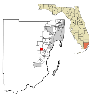
Three Lakes is a census-designated place (CDP) and planned community in Miami-Dade County, Florida, United States. It is part of the Miami metropolitan area of South Florida. The population was 16,540 at the 2020 census, up from 15,047 in 2010.

<span class="mw-page-title-main">Midway, Seminole County, Florida</span> Place in Florida, United States

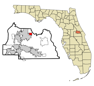
Midway is an unincorporated community and census designated place (CDP) in Seminole County, Florida, United States. The population was 1,524 at the 2020 census. It is part of the Orlando–Kissimmee–Sanford Metropolitan Statistical Area.

Fox Lake Hills is an unincorporated community and census-designated place (CDP) in Lake Villa Township, Lake County, Illinois, United States. Per the 2020 census, the population was 2,684.

<span class="mw-page-title-main">Preston Heights, Illinois</span> Census-designated place in Illinois, United States

Preston Heights is a census-designated place (CDP) in Will County, Illinois, United States. As of the 2020 census, the CDP population was 2,898.

<span class="mw-page-title-main">Brooklyn Park, Maryland</span> Census-designated place in Maryland, United States

Brooklyn Park is a census-designated place (CDP) in Anne Arundel County, Maryland, United States. The population was 14,373 at the 2010 census.

<span class="mw-page-title-main">Lochearn, Maryland</span> Census-designated place in Maryland, United States

Lochearn is an unincorporated community and census-designated place in Baltimore County, Maryland, United States, located immediately to the west of the City of Baltimore. Per the 2020 census, the population was 25,511.

<span class="mw-page-title-main">Milford Mill, Maryland</span> Census-designated place in Maryland, United States

Milford Mill is an unincorporated community and census-designated place in Baltimore County, Maryland, United States. Per the 2020 census, the population was 30,622.

<span class="mw-page-title-main">Bennsville, Maryland</span> Census-designated place in Maryland, United States

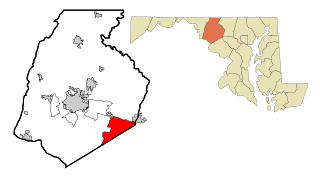
Bennsville is a census-designated place (CDP) in Charles County, Maryland, United States. Per the 2020 census, the population was 15,288. The area is not an official postal designation, but is part of the Waldorf or Pomfret postal area. The Bennsville area is growing with new residential development, encouraged by the extension in the 1990s of Maryland Route 228 which provides quick access to Maryland Route 210. Bennsville has experienced the 2006 opening of North Point High School and the straightening of Middletown Road in 2008.

<span class="mw-page-title-main">Green Valley, Maryland</span> Census-designated place in Frederick County, Maryland, United States

Green Valley is an unincorporated area and census-designated place (CDP) in southern Frederick County, Maryland, United States. The population was 12,643 at the 2020 census. The area was listed as a census-designated place in 2000 but not listed as part of any CDP at the 2010 census. It was re-designated a census-designated place for the 2020 census.

<span class="mw-page-title-main">East Riverdale, Maryland</span> Census-designated place in Maryland, United States

East Riverdale is an unincorporated area and census-designated place (CDP) in Prince George's County, Maryland, United States. The population was 18,459 at the 2020 census.

<span class="mw-page-title-main">Friendly, Maryland</span> Census-designated place in Maryland

Friendly is an unincorporated area and census-designated place (CDP) in Prince George's County, Maryland, United States, with an African-American majority population, located a few miles south of Washington, D.C. The population was 9,937 at the 2020 census.

<span class="mw-page-title-main">Marlow Heights, Maryland</span> Census-designated place in Maryland, United States

Marlow Heights is an unincorporated area and census-designated place (CDP) in Prince George's County, Maryland, United States. The population was 6,169 at the 2020 census. The Marlow Heights Shopping Center first opened in 1957, adjacent to the large community of Hillcrest Heights. It was joined ten years later, in 1967, by the two-level Iverson Mall, the Washington metropolitan area's first enclosed mall.

<span class="mw-page-title-main">Marlton, Maryland</span> Census-designated place in Maryland

Marlton is an unincorporated area and census-designated place (CDP) in Prince George's County, Maryland, United States. The population was 9,802 at the 2020 census. The Marlton housing development, at first briefly called "Brandywine Country", grew up along U.S. Route 301 in the 1970s, and is part of the greater Upper Marlboro community. Originally made up of only single-family homes, more recently townhouses have been added.

<span class="mw-page-title-main">Rosaryville, Maryland</span> Census-designated place in Maryland, US

Rosaryville is an unincorporated area and census-designated place (CDP) in Prince George's County, Maryland, United States, located south of Cinton and Upper Marlboro beside U.S. Route 301. Per the 2020 census, the population was 11,548. including housing developments and rural open space. It was named for a local Roman Catholic church. Close to Rosaryville are the Marlton housing development, Maryland Veterans Cemetery, the Southern Maryland Farmers Market, and Rosaryville State Park.

<span class="mw-page-title-main">South Laurel, Maryland</span> Census-designated place in Maryland

South Laurel is an unincorporated area and census-designated place (CDP) in Prince George's County, Maryland, United States. Per the 2020 census, the population was 29,602.

<span class="mw-page-title-main">Springdale, Maryland</span> Census-designated place in Maryland

Springdale is an unincorporated area and census-designated place (CDP) in Prince George's County, Maryland, United States. Per the 2020 census, the population was 5,301.

<span class="mw-page-title-main">West Laurel, Maryland</span> Census-designated place in Maryland

West Laurel is an unincorporated area and census-designated place (CDP) in Prince George's County, Maryland, United States. Per the 2020 census, the population was 4,428.

<span class="mw-page-title-main">Woodlawn, Prince George's County, Maryland</span> Census-designated place in Maryland

Woodlawn is an unincorporated area and census-designated place (CDP) in Prince George's County, Maryland, United States. As of the 2020 census it had a population of 7,541.

<span class="mw-page-title-main">Calverton, Maryland</span> Census-designated place in Maryland, United States

Calverton is an unincorporated area and census-designated place located on the boundary between Montgomery and Prince George's counties, Maryland, in the United States. At the 2020 census, it had a population of 17,316.

<span class="mw-page-title-main">Hillandale, Maryland</span> Census-designated place in Maryland, United States

Hillandale is an unincorporated area and census-designated place located in Montgomery and Prince George's counties, Maryland, United States. As of the 2020 census, it had a population of 5,774. Hillandale is contained between the Prince George's / Montgomery County line to the east, the Anacostia River to the west, McCeney Avenue to the north, and D.C.'s Capital Beltway to the south. It borders the communities of Adelphi, Avenel, White Oak and Beltsville.

References

  1. "2020 U.S. Gazetteer Files". United States Census Bureau. Retrieved April 26, 2022.
  2. 1 2 U.S. Geological Survey Geographic Names Information System: Fairland, Maryland
  3. "QuickFacts: Fairland CDP, Maryland". United States Census Bureau. Retrieved August 17, 2021.
  4. "Fairland CDP, Maryland". United States Census Bureau . Retrieved April 15, 2022.
  5. "US Gazetteer files: 2010, 2000, and 1990". United States Census Bureau. February 12, 2011. Retrieved April 23, 2011.
  6. "Decennial Census of Population and Housing by Decades". US Census Bureau.
  7. 1 2 "P2 HISPANIC OR LATINO, AND NOT HISPANIC OR LATINO BY RACE – 2010: DEC Redistricting Data (PL 94-171) – Fairland CDP, Maryland". United States Census Bureau .
  8. 1 2 "P2 HISPANIC OR LATINO, AND NOT HISPANIC OR LATINO BY RACE – 2020: DEC Redistricting Data (PL 94-171) – Fairland CDP, Maryland". United States Census Bureau .
  9. "U.S. Census website". United States Census Bureau . Retrieved January 31, 2008.