
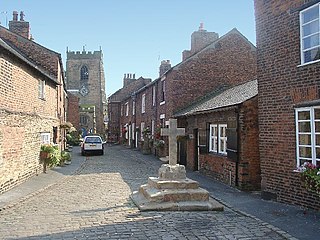
Ruthin is a market town and community in Denbighshire, Wales, in the south of the Vale of Clwyd. It is Denbighshire's county town. The town, castle and St Peter's Square lie on a hill, skirted by villages such as Pwllglas and Rhewl. The name comes from the Welsh rhudd (red) and din (fort), after the colour of sandstone bedrock, from which the castle was built in 1277–1284. The Old Mill, Ruthin, is nearby. Maen Huail, a registered ancient monument attributed to the brother of Gildas and King Arthur, stands in St Peter's Square.

Clayton-le-Woods is a large village and civil parish of the Borough of Chorley, in Lancashire, England. According to the census of 2001, it has a population of 14,528. At the 2011 census the population of Cuerden civil parish was included within Clayton-le-Woods, giving a total of 14,532.
Croston is a village and civil parish near Chorley in Lancashire, England. The River Yarrow flows through the village. The population of the civil parish taken at the 2011 census was 2,917.
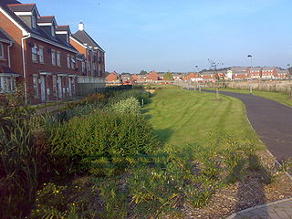
Buckshaw Village is a 21st-century residential and industrial area between the towns of Chorley and Leyland in Lancashire, England, developed on the site of the former Royal Ordnance Factory (ROF) Chorley. It had a population of 4,000. It is divided between the civil parishes of Euxton (south) and Whittle-le-Woods in Chorley, with the north western part being in Leyland unparished area in South Ribble district.

Llandyrnog is a large village and community in Denbighshire, Wales lying in the valley of the River Clwyd, about 3 miles (4.8 km) from Denbigh and 5 miles (8.0 km) from Ruthin. The village has good road links to Denbigh and the main A541 road at Bodfari, and is served by buses number 76 and 53. The village contains the Church of St. Tyrnog's is a Grade II* listed building, and has a notable creamery on the outskirts and former hospital. The community includes the settlements of Waen, Ffordd-las and Llangwyfan.

Leighton and Eaton Constantine is a civil parish in Shropshire, England. It consists of the village of Leighton, together with the smaller villages or hamlets of Eaton Constantine, Upper Longwood and Garmston.

Denbighshire County Council is the unitary local authority for the county of Denbighshire, one of the principal areas of Wales. The council is based at County Hall in Ruthin.

Hellesdon is a village and suburb of Norwich in the District of Broadland in Norfolk, England. It lies approximately four miles (6 km) north-west of Norwich city centre and has a population of 11,132, according to the 2011 Census. Norwich International Airport immediately adjoins the parish.

Ruthin School is a private day and boarding school located on the outskirts of Ruthin, the county town of Denbighshire, North Wales. It is over seven hundred years old, making it one of the oldest schools in the United Kingdom. Originally a school for boys, it has been co-educational since 1990.
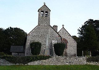
Llanelidan is a small village and community in the county of Denbighshire in north-east Wales. The community also includes the hamlet of Rhyd-y-Meudwy.

Stockland is a village and civil parish in Devon, close to the Somerset boundary. The parish is surrounded clockwise from the north by the parishes of Yarcombe, Membury, Dalwood, Widworthy, Offwell, Cotleigh and Upottery. Its nearest neighbouring towns are Honiton and Axminster, which are 6 miles (10 km) and 5 miles (8 km) away respectively. It has a population of around 600. The village is placed within the Blackdown Hills Area of Outstanding Natural Beauty. The Stockland parish had historically been an exclave of Dorset until the Counties Act 1844.

Northrepps is a village and a civil parish in the English county of Norfolk. It is 3.4 miles (5.5 km) southeast of Cromer, 22.2 miles (35.7 km) north of Norwich and 137 miles (220 km) north of London. The village lies west of the A149 which runs between Kings Lynn and Great Yarmouth. The nearest railway station is at Cromer for the Bittern Line which runs between Sheringham, Cromer and Norwich. The nearest airport is Norwich International Airport. The village and parish of Northrepps had in the 2001 census a population of 839, increasing to 886 at the 2011 Census. For the purposes of local government, the village falls within the district of North Norfolk.

Witherslack is a small village and former civil parish, now in the parish of Witherslack, Meathop and Ulpha, in the Westmorland and Furness district, in the south of Cumbria, England. It lies on the north eastern side of Morecambe Bay, England. The eastern side of the village borders Whitbarrow Scar with Yewbarrow, which is a small limestone hill, located in the centre of the village.

Munslow is a small village and civil parish in Shropshire, England. It is situated on the B4368, 7 miles (11 km) northeast of the small town of Craven Arms, in the Corvedale, at around 140 metres (460 ft) above sea level.

Cwm Gwaun is a community and valley in north Pembrokeshire, Wales. The community is centred around Pontfaen, a parish and hamlet 4 miles (6.4 km) southeast of Fishguard, and includes the ancient parish of Llanychaer. In 2011, the population was 313. The valley is known for its unspoilt nature and old-world pub, and there are numerous other listed buildings.

Nantclwyd Hall is a 17th-century Grade II* listed mansion near the village of Llanelidan, Denbighshire, Wales, built by the Parry family, and rebuilt by Eubule Thelwall and his wife Mary Parry, the heiress of the estate.

Nantclwyd y Dre is a Grade 1 listed house in Ruthin, Denbighshire. It is Wales's oldest dated timbered town house, and is owned by the county and open to the public as a historic house museum.

Clawddnewydd is a village in the community of Derwen, Denbighshire.


