Llanelidan

Last updated

Llanelidan
Llanelidan Parish church - geograph.org.uk - 110023.jpg
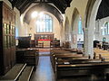
The church from the main road
Denbighshire UK location map.svg
Red pog.svg
Llanelidan
Location within Denbighshire
Population305 (2011)
OS grid reference SJ106504
  Cardiff 108 mi (174 km)
  London 172 mi (277 km)
Community
  • Llanelidan
Principal area
Country Wales
Sovereign state United Kingdom
Post town RUTHIN
Postcode district LL15
Dialling code 01824
Police North Wales
Fire North Wales
Ambulance Welsh
UK Parliament
Senedd Cymru – Welsh Parliament
List of places
UK
Wales
Denbighshire
53°02′35″N3°19′59″W / 53.043°N 3.333°W / 53.043; -3.333

Llanelidan is a small village and community in the county of Denbighshire in north-east Wales. The community also includes the hamlet of Rhyd-y-Meudwy.

Contents

The church, village hall and pub all lie within 200 yards of each other overlooking the village cricket ground and pavilion. Also in the village centre is King George's field, this is land legally protected by the Fields in Trust Charity, and is free for use by anyone. [1] Public space in the village includes the Village Green. This is 3 1/2 acres of registered Village Green Denbighshire Commons Register No. VG12 Ancient and semi natural woodland that is a bluebell wood in the spring. It was allotted to be held IN TRUST for the Community of Llanelidan by the Inclosure Awards of 1861 and is for the enjoyment and recreation of members of the Parish. It lies north west of the village along a footpath towards Coed Pen Y Bryn. Reference ; Public Record Office MAF 1/243 EXMID 13430 and Map date 1816 found at RRO EXMID 15388 Denbigh Record Office QSD/DE/5

Location

Bwrdd y Tri Arglwydd Bwrdd y Tri Arglwydd Bryneglwys Sir Ddinbych Cymru 04.JPG
Bwrdd y Tri Arglwydd

The village of Llanelidan is located just off the A494 road between Ruthin and Corwen in the valley of Afon y Maes, a tributary of the Clwyd. The River Clwyd forms part of the western boundary of the community (parish), which extends further east and south of the village, covering much of the area in the triangle formed by the A-roads joining Ruthin, Corwen and Llandegla. The southernmost tip of the community is marked by Bwrdd y Tri Arglwydd (the table of the three lords), an ancient stone monument marking the point where the lordships of Ruthin, Glyndyfrdwy and Yale met. It is currently the meeting point between the communities of Llanelidan, Bryneglwys, Corwen and Gwyddelwern.

History and amenities

St Elidan Church

Llanelidan is a pretty, scattered hamlet in the green valley of the Afon y Maes, a tributary of the Clwyd. The church - uniquely dedicated to a local saint - stands beside the Leyland Arms public house, surrounded by yews and old Welsh tombstones. Built in the 15th century and ‘double-naved’ in the distinctive local style, it retains many medieval features despite extensive Victorian restoration. There are a pair of barrel-vaulted ‘canopies of honour’ over the altar spaces, fragments of medieval glass - notably the symbols of the crucifixion in blue shields above the altar - and above all a wonderful display of carved woodwork. Sections of the medieval rood screen (which must have been especially fine) are set by the pulpit, including horse-like beasts, intricate roundels, and trails of vines and ivy-berries. The Jacobean pulpit has carvings of its own, with more panels of the same date behind the altar. Old box pews, monuments to successive squires of nearby Nantclwyd Hall, and a touching portrait of the local Roman Catholic martyr Edward Jones are noteworthy. [2]

Church usually open daylight hours. Further information and opening times from Diocesan Office, High Street, St Asaph, LL17 0RD Phone number: 01745 582245 [3]

The village

In December 1873, Major Walter Clopton Wingfield designed an early version of lawn tennis — which he called sphairistike (Greek: σφάίρίστική, meaning "skill at playing at ball"), and was soon known simply as "sticky" — for the amusement of his guests at a garden party at Nantclwyd Hall in Llanelidan. [4] [5] [6]

Llanelidan, the song

A song titled Llanelidan has been written, performed and released to a tune composed by Robat Arwyn. The words portray how Llanelidan's strong and active Welsh community became just a memory due to the actions of Sir Vivian Naylor-Leyland, who intentionally burned down many of the homes of the Welsh-speaking locals on his Nantclwyd estate. In the song, Naylor-Leyland is described as a Fascist

Notes

As of 28 April 2011, this article is derived in whole or in part from medieval-wales.com/index.php. The copyright holder has licensed the content in a manner that permits reuse under CC BY-SA 3.0 and GFDL. All relevant terms must be followed.The original text was at "Llanelidan"

  1. "Llanelidan King George V Playing Field". Fields in Trust. Fields in Trust. Retrieved 17 October 2021.
  2. Dr Charles Kightly. Enjoy Medieval Denbighshire. Denbighshire County Council.
  3. accessdate=2014-05-31, Diocesan Contacts
  4. William Joseph Baker, Sports in the Western World , Champaign, Illinois: University of Illinois Press, 1988, p. 182. ISBN   0-252-06042-3.
  5. Claudio Véliz, The New World of the Gothic Fox: Culture and Economy in English and Spanish America , Berkeley, California: University of California Press, 1994, p. 134. ISBN   0-520-08316-4.
  6. Wimbledon's Welsh roots, BBC News , June 30, 2003. Retrieved October 27, 2013.

Related Research Articles

<span class="mw-page-title-main">Ruthin</span> County town in Wales

Ruthin is a market town and community in Denbighshire, Wales, in the south of the Vale of Clwyd. It is Denbighshire's county town. The town, castle and St Peter's Square lie on a hill, skirted by villages such as Pwllglas and Rhewl. The name comes from the Welsh rhudd (red) and din (fort), after the colour of sandstone bedrock, from which the castle was built in 1277–1284. The Old Mill, Ruthin, is nearby. Maen Huail, a registered ancient monument attributed to the brother of Gildas and King Arthur, stands in St Peter's Square.

<span class="mw-page-title-main">Denbighshire</span> County in Wales

Denbighshire is a county in the north-east of Wales. It borders the Irish Sea to the north, Flintshire to the east, Wrexham to the southeast, Powys to the south, and Gwynedd and Conwy to the west. Rhyl is the largest town, and Ruthin is the administrative centre. Its borders differ from the historic county of the same name.

<span class="mw-page-title-main">River Clwyd</span> River in Wales

The River Clwyd is a river in Wales that rises in the Clocaenog Forest 5 mi (8 km) northwest of Corwen. Its total length is 35 mi (56 km).

<span class="mw-page-title-main">Clwyd</span> Preserved county of Wales

Clwyd is a preserved county of Wales, situated in the north-east corner of the country; it is named after the River Clwyd, which runs through the area. To the north lies the Irish Sea, with the English ceremonial counties of Cheshire to the east and Shropshire to the south-east. Powys and Gwynedd lie to the south and west respectively. Clwyd also shares a maritime boundary with Merseyside along the River Dee. Between 1974 and 1996, a slightly different area had a county council, with local government functions shared with six district councils. In 1996, Clwyd was abolished, and the new principal areas of Conwy County Borough, Denbighshire, Flintshire and Wrexham County Borough were created; under this reorganisation, "Clwyd" became a preserved county, with the name being retained for certain ceremonial functions.

<span class="mw-page-title-main">Corwen</span> Town in Denbighshire, Wales

Corwen is a town and community in the county of Denbighshire in Wales. Historically, Corwen was part of the county of Merionethshire. Corwen stands on the banks of the River Dee beneath the Berwyn mountains. The town is situated 10 miles (16 km) west of Llangollen and 13 miles (21 km) south of Ruthin. At the 2011 Census, Corwen had a population of 2,325, decreasing slightly from the 2001 population of 2,398, The community, with an area of 69.51 km2 (26.84 sq mi), includes Corwen and the surrounding villages of Carrog, Clawdd Poncen and Glyndyfrdwy. The Office for National Statistics identifies Corwen Built-up area with a 2011 population of 477 and an area of 0.25 km2 (0.097 sq mi).

<span class="mw-page-title-main">Gwyddelwern</span> Human settlement in Wales

Gwyddelwern is a small village and community of 508 residents, reducing to 500 at the 2011 census, situated approximately 2 miles (3.2 km) north of Corwen in Denbighshire in Wales. Historically the village was part of the Edeyrnion district of Meirionnydd. Edeyrnion was part of the Glyndŵr district of Clwyd from 1974 to 1996, when the area became part of the principal area of Denbighshire. The village straddles the A494 road.

The Vale of Clwyd is a tract of low-lying ground in the county of Denbighshire in north-east Wales. The Vale extends south-southwestwards from the coast of the Irish Sea for some 20 miles forming a triangle of low ground bounded on its eastern side by the well-defined scarp of the Clwydian Range and to the west by numerous low hills. The River Clwyd which rises within Clocaenog Forest, southwest of Denbigh, runs the full length of the vale. It is joined by the two major left bank tributaries of the River Clywedog and River Elwy and the smaller right bank tributary of the River Wheeler.

<span class="mw-page-title-main">Llanfair Dyffryn Clwyd</span> Village in Denbighshire, Wales

Llanfair Dyffryn Clwyd is a village and community in Denbighshire, Wales, situated in the Vale of Clwyd about one mile south of the town of Ruthin. By the 2001 census, it had 1048 residents and 50.6% of them could speak Welsh. The figures for the 2011 census were: population 1,053:Welsh speakers 46.9%. The age group with the highest percentage of Welsh speakers was the 15-year-olds where every one could speak it. The villages of Pentrecelyn and Graig Fechan are located in the community.

<span class="mw-page-title-main">Llanfwrog, Denbighshire</span> Village in Denbighshire, Wales

Llanfwrog is a village in Denbighshire, in northern Wales. It hosts a church, Llanfwrog Church of St Mwrog and St Mary. The sturdy medieval tower of St Mwrog's crowns the hill west of Ruthin, marking the point where town gives way to countryside. ‘Double-naved’ in the distinctive Clwydian style, the church is late medieval, but was much altered by Victorian restoration. The church was again restored in 1999. There are fine views from the circular 'Celtic' churchyard – St Mwrog was a little-known Welsh saint, perhaps from Anglesey. On a rise to the south by the road to Efenechtyd stands an ancient thatched and whitewashed house (private).

<span class="mw-page-title-main">Aberwheeler</span> Village in Denbighshire, Wales

Aberwheeler is a village and community in the Welsh county of Denbighshire, located on the south bank of the River Wheeler, 4.2 miles (6.8 km) north east of Denbigh, 12.6 miles (20.3 km) north west of Mold and 11.0 miles (17.7 km) north of Ruthin. At the 2001 census the community had a population of 327, reducing to 298 at the 2011 census. The name has been Anglicised from the Welsh.

<span class="mw-page-title-main">Cyffylliog</span> Village in Denbighshire, Wales

Cyffylliog is a village and community in Denbighshire, Wales. It is situated to the west of Ruthin on the banks of the River Clywedog. The community covers an area of 31.59 km2 and includes the hamlet of Bontuchel and a section of Clocaenog Forest. It had a population of 495 at the time of the 2011 census, a slight increase from 484 during the 2001 census. The name of the village means "place of pollard trees/stumps" and comes from the Welsh word cyffyll meaning stumps.

<span class="mw-page-title-main">Nantclwyd Hall</span> Mansion in Denbighshire, Wales

Nantclwyd Hall is a 17th-century Grade II* listed mansion near the village of Llanelidan, Denbighshire, Wales, built by the Parry family, and rebuilt by Eubule Thelwall and his wife Mary Parry, the heiress of the estate.

<span class="mw-page-title-main">Nantclwyd y Dre</span> Building in Denbighshire, Wales

Nantclwyd y Dre is a Grade 1 listed house in Ruthin, Denbighshire. It is Wales's oldest dated timbered town house, and is owned by the county and open to the public as a historic house museum.

<span class="mw-page-title-main">Clocaenog</span> Village in Denbighshire, Wales

Clocaenog is a village and community in Denbighshire, north-east Wales. It lies on the outskirts of Ruthin and the Clocaenog Forest. The forest near the village has many walks of varying length and is one of the venues for the Wales Rally GB.

<span class="mw-page-title-main">Llanynys</span> Hamlet in Denbighshire, Wales

Llanynys is a hamlet and community in Denbighshire, north-east Wales;. It lies in the Vale of Clwyd, a few miles north of Ruthin, and includes the village of Rhewl.

Afon y Maes is a tributary river to the Clwyd and flows through the village of Llanelidan, Denbighshire, Wales. The river starts to the south of the village and joins up to the Clwyd on land behind Nantclwyd Hall, and therefore it is a relatively short river that starts and ends in the same town.

<span class="mw-page-title-main">Leyland Arms, Llanelidan</span> Building in Denbighshire, Wales

The Leyland Arms is a Grade II listed building in the community of Llanelidan near Ruthin, Denbighshire, Wales, which dates back to 1354. It was listed by Cadw.

<span class="mw-page-title-main">Eubule Thelwall (landowner)</span>

Eubule Thelwall was a landowner and solicitor who held legal offices in North Wales and Cheshire, and the third son of John Thelwall of Bathafarn Park, Ruthin. In 1646 he served in the siege of Denbigh Castle and was sent by William Salesbury, the castle's governor, to Charles I to seek his permission to surrender. Thelwall married Marry Parry, the heiress of Nantclwyd estate in 1653 and instigated a complete rebuild of the building and of a second, smaller building in the nearby town of Ruthin: Nantclwyd y Dre, which is Wales's oldest dated timbered town house.

Llanrhydd or Llanrhudd is a parish one and a half miles south-west of Ruthin in Denbighshire, Wales; 'rhudd' being the Welsh name for 'red' – the colour of the local sandstone.