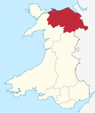
Flintshire is a county in the north-east of Wales. It has a maritime border with Merseyside along the Dee Estuary to the north, and land borders with Cheshire to the east, Wrexham County Borough to the south, and Denbighshire to the west. Connah's Quay is the largest town, while Flintshire County Council is based in Mold.
Until 1974, Flintshire, also known as the County of Flint, was an administrative county in the north-east of Wales, later classed as one of the thirteen historic counties of Wales.
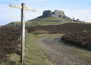
Moel Famau is the highest hill in the Clwydian Range and the highest point of the county of Flintshire in Wales. It lies on the boundary between Denbighshire and Flintshire. The hill, which also gives its name to the Moel Famau country park, has been classed as an Area of Outstanding Natural Beauty since 1985. It is also surrounded by several well-preserved Iron Age hill forts. It is also the third-highest peak in the extended AONB of the Clwydian Range and Dee Valley.
Clwyd is a preserved county of Wales, situated in the north-east corner of the country; it is named after the River Clwyd, which runs through the area. To the north lies the Irish Sea, with the English ceremonial counties of Cheshire to the east and Shropshire to the south-east. Powys and Gwynedd lie to the south and west respectively. Clwyd also shares a maritime boundary with Merseyside along the River Dee. Between 1974 and 1996, a slightly different area had a county council, with local government functions shared with six district councils. In 1996, Clwyd was abolished, and the new principal areas of Conwy County Borough, Denbighshire, Flintshire and Wrexham County Borough were created; under this reorganisation, "Clwyd" became a preserved county, with the name being retained for certain ceremonial functions.

The River Dee is a river flowing through North Wales, and through Cheshire, England, in Great Britain. The length of the main section from Bala to Chester is 113 km and it is largely located in Wales. The stretch between Aldford and Chester is within England, and two other sections form the border between the two countries.

Wrexham County Borough is a county borough, with city status, in the north-east of Wales. It borders the English ceremonial counties of Cheshire and Shropshire to the east and south-east respectively, Powys to the south-west, Denbighshire to the west and Flintshire to the north-west. The city of Wrexham is the administrative centre. The county borough is part of the preserved county of Clwyd.

Watson Lake is a town in Yukon, Canada, located at mile 635 on the Alaska Highway close to the British Columbia border. It has a population of 790 in 2016. The town is named for Frank Watson, an American-born trapper and prospector, who settled in the area at the end of the 19th century.

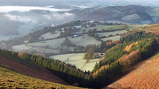
The River Alyn is a tributary of the River Dee in north-east Wales. It rises at the southern end of the Clwydian hills and the Alyn Valley forms part of the Clwydian Range and Dee Valley Area of Outstanding Natural Beauty. The main town on the river is Mold, the county town of Flintshire. It lends its name to the constitutencies of Alyn and Deeside in the UK Parliament and the Senedd.

Llanarmon-yn-Iâl is a village, and local government community, in Denbighshire, Wales, lying in limestone country in the valley of the River Alyn.

The Eglwyseg valley is an area to the north east of Llangollen in Denbighshire, Wales; it is within the boundaries of Llantysilio Community. The name also refers to a widely scattered hamlet in the valley.
The Alyn Gorge is a gorge section of the River Alyn north between Loggerheads and Rhydymwyn in Wales. The west side of the valley rises gently to Moel Famau, while the east bank is along parts a cliff with evidence of tram lines and old quarry workings.

Llanferres is a village and community in the county of Denbighshire in Wales. At the 2001 Census the population of the village was recorded as 676, increasing to 827 at the 2011 census.

Maeshafn is a small village in Denbighshire, Wales, near the border with Flintshire.
The Milwr Tunnel is a mine drainage adit running some 10 miles from the hamlet of Cadole near Loggerheads, Denbighshire to Bagillt on the Dee Estuary in North Wales. It was originally built to drain the lead mines beneath Halkyn Mountain, which were plagued with flooding in their lower levels, but enabled the exploitation of new lodes and was variously used for the extraction of lead, zinc and limestone during its working history. It is part of a network of mines, lodes and natural cave systems – the Halkyn United Mines – that extends for up to 100 kilometres, the longest in the United Kingdom.

Eryrys is a village in Denbighshire, Wales, located at approximate grid reference SJ203578, five miles south of Mold. The village is built on the limestone formation of Bryn Alyn and many limestone outcrops can be seen close by. At 355m above sea level, Eryrys is one of a number of villages with a valid claim to be the highest in Wales; others include Bwlchgwyn, Wrexham, and Garn-yr-Erw, Torfaen.

Rhydymwyn is a village in Flintshire, Wales, located in the upper Alyn valley. Once a district of Mold, it was recognised as a separate parish from 1865. It is now part of the community of Cilcain.

Alyn Valley Woods and Alyn Gorge Caves is a Site of Special Scientific Interest on the border of Flintshire and Denbighshire in north Wales. Most of the site is also designated as the Alyn Valley Woods Special Area of Conservation and the southern part includes Loggerheads Country Park. The SSSI has an area of 190.3 hectares while the SAC covers 168.3 hectares.
The Rofft was a historic site at Marford in the Wrexham County Borough. It was initially a pre-historic camp, and later a motte and bailey castle. There are no visible remains of the site today.

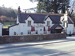
Loggerheads Country Park is a country park in the village of Loggerheads, Denbighshire, Wales. The park has a wooded river valley that follows the course of the River Alyn and high cliffs from within the Clwydian Range of mountains, with views of the range's tallest mountain Moel Famau. The park has a visitor centre, woodland walks, and two landmarks—a historic corn mill called Pentre Mill, and a gorge called Devil's Gorge.
The Clwydian Range and Dee Valley is a designated Area of Outstanding Natural Beauty (AONB) located in north-east Wales, covering the Clwydian Range, and the valley of the River Dee.