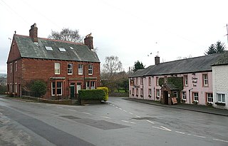
Corwen is a town and community in the county of Denbighshire in Wales. Historically, Corwen was part of the county of Merionethshire. Corwen stands on the banks of the River Dee beneath the Berwyn mountains. The town is situated 10 miles (16 km) west of Llangollen and 13 miles (21 km) south of Ruthin. At the 2011 Census, Corwen had a population of 2,325, decreasing slightly from the 2001 population of 2,398, The community, with an area of 69.51 km2 (26.84 sq mi), includes Corwen and the surrounding villages of Carrog, Clawdd Poncen and Glyndyfrdwy. The Office for National Statistics identifies Corwen Built-up area with a 2011 population of and an area of 0.25 km2 (0.097 sq mi).
Llanrhaeadr-ym-Mochnant is a village, community and an ecclesiastical parish in the extreme north of Powys, Wales; about 9 miles west of Oswestry and 12 miles south of Llangollen, on the B4580. It lies near the foothills of the Berwyn mountains on the river Rhaeadr. At the top end of the valley is the Pistyll Rhaeadr waterfall, one of the Seven Wonders of Wales in the old rhyme. One mile north of the town is the hill Moel Hen-fache. The community includes the hamlet of Llanarmon Mynydd Mawr.

Llanfynydd is a village, parish and community in Carmarthenshire, Wales. The community population at the 2011 census was 499. It lies some 10 miles north-east of the county town, Carmarthen. Bordering it are the communities of Llansawel, Talley, Manordeilo and Salem, Llangathen, Llanegwad and Llanfihangel Rhos-y-Corn, all in Carmarthenshire.

The Diocese of Saint Asaph is a diocese of the Church in Wales in north-east Wales, named after Saint Asaph, its second bishop.
Elwick is a village and civil parish in the borough of Hartlepool and the ceremonial county of County Durham, in England. It is situated near the A19 road to the west of Hartlepool. Hartlepool Borough Council governs Elwick. As Elwick is only a small parish it is not able to run itself as its own district. It does have a Parish Council. Elwick was known as a township until 1866, but then was changed to a civil parish status.
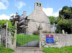
Saint Mael and Saint Sulien's Church is a church located in the town of Corwen in Denbighshire in Wales. It was formerly in the ancient county of Merionethshire.

Llysfaen is a village and community in Conwy County Borough overlooking the north coast of Wales, and situated on the hill Mynydd Marian. For local government purposes, it is also a ward. The community includes the Peulwys estate of Old Colwyn.

Dinas Cross is both a village, a community and a former parish in Pembrokeshire, Wales. Located between Fishguard and Newport in the Pembrokeshire Coast National Park, it is a popular holiday destination on the A487 road. The two hamlets, Cwm-yr-Eglwys and Pwllgwaelod, are in the community. The community has an elected community council and until 2022 gave its name to an electoral ward of Pembrokeshire County Council which covered the communities of Dinas Cross, Cwm Gwaun and Puncheston.

Llansilin is a village and local government community in Montgomeryshire, Powys, Wales, 5 miles (8 km) west of Oswestry. The community, which includes Llansilin village, a large rural area and the hamlets of Moelfre and Rhiwlas as well as the remote parish of Llangadwaladr, had a population of 648 at the 2001 census, increasing to 698 at the 2011 Census. There is also an electoral ward including the nearby village of Llanrhaeadr-ym-Mochnant with a population of 2,295.

Llanbadarn Fawr is a village and community in Ceredigion, Wales. It is on the outskirts of Aberystwyth next to Penparcau and Southgate. It forms the eastern part of the continually built-up area of Aberystwyth. It holds two electoral wards, Padarn and Sulien which elect a Ceredigion County Councillor each and several Llanbadarn Fawr Community Councillors. At the 2001 census its population as a community was recorded at 2,899, increasing to 3,380 at the 2011 census.

Skeffling is a village and civil parish in the East Riding of Yorkshire, England, in an area known as Holderness. It is situated approximately 5 miles (8 km) south of the town of Withernsea and 4 miles (6.4 km) south-east of the village of Patrington on the B1445 road from Patrington to Easington.
Armathwaite is a village in the English ceremonial county of Cumbria.
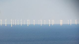
Gwynt y Môr is a 576-megawatt (MW) offshore wind farm located off the coast of Wales and is the fifth largest operating offshore windfarm in the world. The farm has 160 wind turbines of 150 metres (490 ft) tip height above mean sea level.

Llanllwni is a village and community in Carmarthenshire, Wales, on the A485 road south-west of Llanybydder. To the south lies the mountain, Mynydd Llanllwni. The population of 638 recorded in the 2011 Census was estimated to be 692 in 2019.

Maël was a fifth-century Breton saint who lived as a hermit in Wales. He was a follower of Cadfan from Brittany to Wales, ultimately to the Isle of Bardsey. His feast day is 13 May.
Silian, originally Sulien, is a village in the valley of the River Teifi, Ceredigion, Wales. It is located approximately two miles north-west of Lampeter, on a minor road connecting Pont Creuddun on the A482, and Glan Denys on the A485.
QBlade is a public source, cross-platform simulation software for wind turbine blade design and aerodynamic simulation. It comes with a user-friendly graphical user interface (GUI) based on Qt.

Efenechtyd is a hamlet and community in a deep valley in Denbighshire, Wales which contains the Church of St Michael and All Angels. The community includes the village of Pwllglas. Efenechtyd is also the name of an electoral ward.

Rhuallt is a village in Denbighshire, Wales. The village is situated approximately 5 mi (8.0 km) south of Prestatyn and 2 mi (3.2 km) east of St Asaph on the B5429 road, adjacent to the A55, and has a caravan site. There is one public house, The White House. Another public house, The Smithy Arms, closed permanently in or around 2014. Some elements of village life in Rhuallt were described in the BBC Domesday Project of 1986. Rhuallt is mostly in the community of Tremeirchion, with some outlying parts in Cwm, Denbighshire.