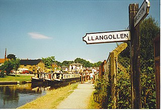
Llangollen is a town and community, situated on the River Dee, in Denbighshire, Wales. Its riverside location forms the edge of the Berwyn range, and the Dee Valley section of the Clwydian Range and Dee Valley Area of Outstanding Natural Beauty, with the easternmost point of the Dee Valley Way being within the town. It had a population of 3,658 at the 2011 census.

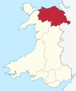
Denbighshire is a county in the north-east of Wales. It borders the Irish Sea to the north, Flintshire to the east, Wrexham to the southeast, Powys to the south, and Gwynedd and Conwy to the west. Rhyl is the largest town, and Ruthin is the administrative centre. Its borders differ from the historic county of the same name.

Historic Denbighshire is one of thirteen traditional counties in Wales, a vice-county and a former administrative county, which covers an area in north east Wales. It is a maritime county, bounded to the north by the Irish Sea, to the east by Flintshire, Cheshire and Shropshire, to the south by Montgomeryshire and Merionethshire, and to the west by Caernarfonshire.
Clwyd is a preserved county of Wales, situated in the north-east corner of the country; it is named after the River Clwyd, which runs through the area. To the north lies the Irish Sea, with the English ceremonial counties of Cheshire to the east and Shropshire to the south-east. Powys and Gwynedd lie to the south and west respectively. Clwyd also shares a maritime boundary with Merseyside along the River Dee. Between 1974 and 1996, a slightly different area had a county council, with local government functions shared with six district councils. In 1996, Clwyd was abolished, and the new principal areas of Conwy County Borough, Denbighshire, Flintshire and Wrexham County Borough were created; under this reorganisation, "Clwyd" became a preserved county, with the name being retained for certain ceremonial functions.

The River Dee is a river in the United Kingdom. The length of the main section from Bala to Chester is 113 km and it is largely located in Wales. The stretch between Aldford and Chester is within England, and two other sections form the border between the two countries.

Horseshoe Falls is a weir on the River Dee near Llantysilio Hall in Denbighshire, Wales, about 5 kilometres (3 mi) north-west of the town of Llangollen.

Corwen is a town and community in the county of Denbighshire in Wales. Historically, Corwen was part of the county of Merionethshire. Corwen stands on the banks of the River Dee beneath the Berwyn mountains. The town is situated 10 miles (16 km) west of Llangollen and 13 miles (21 km) south of Ruthin. At the 2011 Census, Corwen had a population of 2,325, decreasing slightly from the 2001 population of 2,398, The community, with an area of 69.51 km2 (26.84 sq mi), includes Corwen and the surrounding villages of Carrog, Clawdd Poncen and Glyndyfrdwy. The Office for National Statistics identifies Corwen Built-up area with a 2011 population of 477 and an area of 0.25 km2 (0.097 sq mi).
Llanrhaeadr-ym-Mochnant is a village, community and an ecclesiastical parish in the extreme north of Powys, Wales; about 9 miles west of Oswestry and 12 miles south of Llangollen, on the B4580. It lies near the foothills of the Berwyn mountains on the river Rhaeadr. At the top end of the valley is the Pistyll Rhaeadr waterfall, one of the Seven Wonders of Wales in the old rhyme. One mile north of the town is the hill Moel Hen-fache. The community includes the hamlet of Llanarmon Mynydd Mawr.

Chirk is a town and community in Wrexham County Borough, Wales, 10 miles south of Wrexham, between it and Oswestry. At the 2011 census, it had a population of 4,468. Historically in the traditional county of Denbighshire, and later Clwyd, it has been part of Wrexham County Borough since a local government reorganisation in 1996. The border with the English county of Shropshire is immediately south of the town, on the other side of the River Ceiriog.

Wrexham County Borough is a county borough, with city status, in the north-east of Wales. It borders the English ceremonial counties of Cheshire and Shropshire to the east and south-east respectively, Powys to the south-west, Denbighshire to the west and Flintshire to the north-west. The city of Wrexham is the administrative centre. The county borough is part of the preserved county of Clwyd.
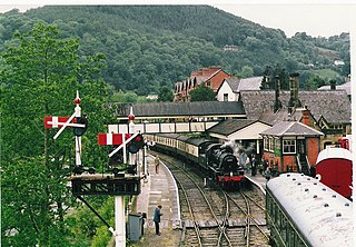
The Llangollen Railway is a volunteer-run heritage railway in Denbighshire, North Wales, which operates between Llangollen and Corwen. The standard gauge line, which is 10 miles (16 km) long, runs on part of the former Ruabon – Barmouth GWR route that closed in 1965. It operates daily services in the summer as well as weekends throughout the winter months, using a variety of mainly ex-GWR steam locomotives as well as several diesel engines and diesel multiple units. A 2+1⁄2 miles (4 km) extension of the railway has been built to complete the line to Corwen.

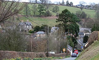
Glyndyfrdwy, or sometimes Glyn Dyfrdwy, is a village in the modern county of Denbighshire, Wales. It is situated on the A5 road halfway between Corwen and Llangollen in the Dee Valley.

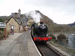
Llangollen railway station in the town of Llangollen, Denbighshire, Wales, is a preserved railway station on the former Ruabon to Barmouth Line, and now the eastern terminus of the preserved Llangollen Railway.

Berwyn railway station in Denbighshire, Wales, is a railway station on the former cross-country line between Ruabon and Barmouth. The station, which opened in May 1865, was a stop on the Great Western Railway (GWR) line between Llangollen and Corwen. It remained open for almost a hundred years, and it was due to be closed to passengers on Monday 18 January 1965. However, it was closed prematurely due to flood damage on 14 December 1964.
Trevor is a village in Wrexham County Borough, Wales. It is situated in the scenic Vale of Llangollen, on the A539 between Llangollen and Wrexham, in the community of Llangollen Rural, and in the historic county of Denbighshire.
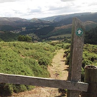
The Dee Valley Way is a Hiking Trail that runs between Corwen and Llangollen in north Wales. The Way is 21 km long. The guide splits it into five sections that are accessible by road.

Llantysilio Hall is a Grade II* listed country house in Llantysilio, near Llangollen in Denbighshire. It is on the bank of the River Dee and adjacent to the historic Horseshoe Falls, the source of the Llangollen Canal.

The Chain Bridge is a footbridge over the River Dee at Berwyn, Llangollen, Denbighshire, north Wales.

Llantysilio Church is a parish church in Llantysilio, near Llangollen, Denbighshire, North Wales.
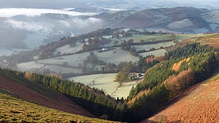
The Clwydian Range and Dee Valley is a designated Area of Outstanding Natural Beauty (AONB) located in north-east Wales, covering the Clwydian Range, and the valley of the River Dee.