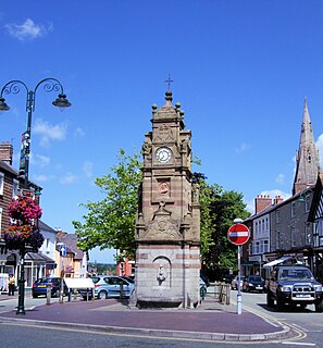
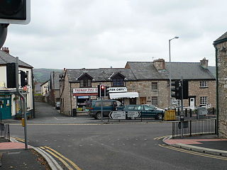
Ruthin is a market town and community in Denbighshire, Wales, in the south of the Vale of Clwyd. It is Denbighshire's county town. The town, castle and St Peter's Square lie on a hill, skirted by villages such as Pwllglas and Rhewl. The name comes from the Welsh rhudd (red) and din (fort), after the colour of sandstone bedrock, from which the castle was built in 1277–1284. The Old Mill, Ruthin, is nearby. Maen Huail, a registered ancient monument attributed to the brother of Gildas and King Arthur, stands in St Peter's Square.
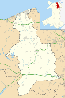
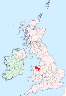
Denbighshire is a county in the north-east of Wales. Its borders differ from the historic county of the same name. This part of Wales contains the country's oldest known evidence of habitation – Pontnewydd (Bontnewydd-Llanelwy) Palaeolithic site has Neanderthal remains of some 225,000 years ago. Castles include Denbigh, Rhuddlan, Ruthin, Castell Dinas Bran and Bodelwyddan. St Asaph, one of Britain's smallest cities, has one of its smallest Anglican cathedrals.
Historic Denbighshire is one of thirteen traditional counties in Wales, a vice-county and a former administrative county, which covers an area in north east Wales. It is a maritime county, bounded to the north by the Irish Sea, to the east by Flintshire, Cheshire and Shropshire, to the south by Montgomeryshire and Merionethshire, and to the west by Caernarfonshire.

The River Clwyd is a river in Wales that rises in the Clocaenog Forest 5 mi (8 km) northwest of Corwen. Its total length is 35 mi (56 km).

Corwen is a town and community in the county of Denbighshire in Wales. Historically, Corwen is part of the county of Merionethshire. Corwen stands on the banks of the River Dee beneath the Berwyn mountains. The town is situated 10 miles (16 km) west of Llangollen and 13 miles (21 km) south of Ruthin. At the 2001 Census, Corwen had a population of 2,325, decreasing slightly from the 2001 population of 2,398, The community, with an area of 69.51 km2 (26.84 sq mi), includes Corwen and the surrounding villages of Carrog, Clawdd Poncen and Glyndyfrdwy. The Office for National Statistics identifies Corwen Built-up area with a 2011 population of and an area of 0.25 km2 (0.097 sq mi).

Denbigh is a market town and a community in Denbighshire, Wales. Formerly, the county town, the Welsh name translates to "Little Fortress"; a reference to its historic castle. Denbigh lies near the Clwydian Hills.
Ysgol Brynhyfryd is a bilingual co-educational comprehensive school in the town of Ruthin in Denbighshire, North Wales. The school serves the community of Ruthin and the many surrounding villages including the rural districts of Corwen, Carrog and Gwyddelwern. The bilingual ethos reflects the community it serves.
The Vale of Clwyd is a tract of low-lying ground in the county of Denbighshire in north-east Wales. The Vale extends south-southwestwards from the coast of the Irish Sea for some 20 miles forming a triangle of low ground bounded on its eastern side by the well-defined scarp of the Clwydian Range and to the west by numerous low hills. The River Clwyd which rises within Clocaenog Forest, southwest of Denbigh, runs the full length of the vale. It is joined by the two major left bank tributaries of the River Clywedog and River Elwy and the smaller right bank tributary of the River Wheeler.

Coedpoeth is a village and community in Wrexham County Borough, Wales. The built-up area with Minera had a population of 5,723 in the 2011 census.

The A525 is a major route from Rhyl in Wales to Newcastle-under-Lyme in England. On the way, it passes near to Denbigh, through Ruthin, through Wrexham and near Whitchurch.

Corwen railway station was a railway station on the Ruabon to Barmouth Line, located in the town of Corwen in Denbighshire, Wales.
The Denbigh, Ruthin and Corwen Railway was a standard gauge railway line that connected Corwen with Denbigh via Ruthin in North Wales.

Ruthin Railway Station served the town of Ruthin in Denbighshire, Wales, between the 1862 and 1962. It was the main headquarters of the Denbigh, Ruthin and Corwen Railway. It had two platforms, a bay siding and a goods shed that opened into a second bay platform. The station was demolished after closure and the Ruthin Craft Centre was built in its place. A goods crane at the Craft Centre's car park entrance is all that remains of the station.
Trefnant is a village and community in Denbighshire, Wales. It is located on the A525 road in the Vale of Clwyd, about halfway between St Asaph (Llanelwy) to the north and Denbigh to the south. At the 2001 Census, the community had a population of 1,409, increasing to 1,581 at the 2011 Census.
The Ruthin and Cerrig-y-Drudion Railway was a proposed 1 ft 11+1⁄2 in narrow gauge railway that would have linked the towns of Ruthin and Cerrig-y-Drudion in Denbighshire, Wales. A bill was put before Parliament in 1873, promoting the railway, which was intended to meet the planned branch of the North Wales Narrow Gauge Railways from Beddgelert at Cerrig-y-Drudion.

Llanrhaeadr-yng-Nghinmeirch is a village and local government community in Denbighshire, Wales, including the villages of Llanrhaeadr and Pentre Llanrhaeadr and several hamlets, including Saron, Pant Pastynog, Prion, Peniel and part of Mynydd Hiraethog. It lies in the Vale of Clwyd near the A525 road between Denbigh and Ruthin. It was also known under the anglicised spellings of Llanrhaiadr in Kinmerch in the nineteenth century, and Llanrhaiadr yn Cinmerch, officially until 6 September 1968. The Community population taken at the 2011 census was 1,038.

The River Clywedog is a tributary of the River Clwyd in northeast Wales. The river rises within Clocaenog Forest and flows in a generally easterly direction through the villages of Cyffylliog, Bontuchel and Rhewl before turning northwards to join the Clwyd to the east of Denbigh.

Cyffylliog is a village and community in Denbighshire, Wales. It is situated to the west of Ruthin on the banks of the River Clywedog. The community covers an area of 31.59 km2 and includes the hamlet of Bontuchel and a section of Clocaenog Forest. It had a population of 495 at the time of the 2011 census, a slight increase from 484 during the 2001 census. The name of the village means "place of pollard trees/stumps" and comes from the Welsh word cyffyll meaning stumps.
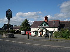
Llanynys is a hamlet and community in Denbighshire, north-east Wales;. It lies in the Vale of Clwyd, a few miles north of Ruthin, and includes the village of Rhewl.