- Map of places in Denbighshire compiled from this list
- See the list of places in Wales for places in other principal areas.
This is a list of towns and villages in the principal area of Denbighshire, Wales.
This is a list of towns and villages in the principal area of Denbighshire, Wales.
| | This section is empty. You can help by adding to it. (July 2010) |
| | This section is empty. You can help by adding to it. (July 2010) |
| | This section is empty. You can help by adding to it. (July 2010) |
| | This section is empty. You can help by adding to it. (July 2010) |
| | This section is empty. You can help by adding to it. (July 2010) |
Peniel
| | This section is empty. You can help by adding to it. (July 2010) |
| | This section is empty. You can help by adding to it. (July 2010) |
| | This section is empty. You can help by adding to it. (July 2010) |
| | This section is empty. You can help by adding to it. (July 2010) |
| | This section is empty. You can help by adding to it. (July 2010) |
| | This section is empty. You can help by adding to it. (July 2010) |
| | This section is empty. You can help by adding to it. (July 2010) |

Powys is a county and preserved county in Wales. It borders Gwynedd, Denbighshire, and Wrexham to the north; the English ceremonial counties of Shropshire and Herefordshire to the east; Monmouthshire, Blaenau Gwent, Merthyr Tydfil, Caerphilly, Rhondda Cynon Taf, and Neath Port Talbot to the south; and Carmarthenshire and Ceredigion to the west. The largest settlement is Newtown, and the administrative centre is Llandrindod Wells.

Ruthin is a market town and community in Denbighshire, Wales, in the south of the Vale of Clwyd. It is Denbighshire's county town. The town, castle and St Peter's Square lie on a hill, skirted by villages such as Pwllglas and Rhewl. The name comes from the Welsh rhudd (red) and din (fort), after the colour of sandstone bedrock, from which the castle was built in 1277–1284. The Old Mill, Ruthin, is nearby. Maen Huail, a registered ancient monument attributed to the brother of Gildas and King Arthur, stands in St Peter's Square.

Merionethshire or Merioneth is one of thirteen historic counties of Wales, a vice county and a former administrative county.

Montgomeryshire is one of thirteen historic counties and a former administrative county of Wales. It is named after its county town, Montgomery, which in turn is named after one of William the Conqueror's main counsellors, Roger de Montgomerie, who was the 1st Earl of Shrewsbury.
Conwy County Borough is a county borough in the north of Wales. It borders Gwynedd to the west and south and Denbighshire to the east. The largest settlement is Colwyn Bay, and Conwy is the administrative centre.

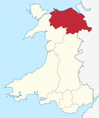
Denbighshire is a county in the north-east of Wales. It borders the Irish Sea to the north, Flintshire to the east, Wrexham to the southeast, Powys to the south, and Gwynedd and Conwy to the west. Rhyl is the largest town, and Ruthin is the administrative centre. Its borders differ from the historic county of the same name.

Flintshire is a county in the north-east of Wales. It has a maritime border with Merseyside along the Dee Estuary to the north, and land borders with Cheshire to the east, Wrexham County Borough to the south, and Denbighshire to the west. Connah's Quay is the largest town, while Flintshire County Council is based in Mold.
Flintshire, also known as the County of Flint, is one of Wales' thirteen historic counties, and a former administrative county. It mostly lies on the north-east coast of Wales.

Historic Denbighshire is one of thirteen traditional counties in Wales, a vice-county and a former administrative county, which covers an area in north east Wales. It is a maritime county, bounded to the north by the Irish Sea, to the east by Flintshire, Cheshire and Shropshire, to the south by Montgomeryshire and Merionethshire, and to the west by Caernarfonshire.

The River Clwyd is a river in Wales that rises in the Clocaenog Forest 5 mi (8 km) northwest of Corwen. Its total length is 35 mi (56 km).
Clwyd is a preserved county of Wales, situated in the north-east corner of the country; it is named after the River Clwyd, which runs through the area. To the north lies the Irish Sea, with the English ceremonial counties of Cheshire to the east and Shropshire to the south-east. Powys and Gwynedd lie to the south and west respectively. Clwyd also shares a maritime boundary with Merseyside along the River Dee. Between 1974 and 1996, a slightly different area had a county council, with local government functions shared with six district councils. In 1996, Clwyd was abolished, and the new principal areas of Conwy County Borough, Denbighshire, Flintshire and Wrexham County Borough were created; under this reorganisation, "Clwyd" became a preserved county, with the name being retained for certain ceremonial functions.

North Wales is a region of Wales, encompassing its northernmost areas. It borders mid Wales to the south, England to the east, and the Irish Sea to the north and west. The area is highly mountainous and rural, with Snowdonia National Park and the Clwydian Range and Dee Valley, known for its mountains, waterfalls and trails, wholly within the region. Its population is concentrated in the north-east and northern coastal areas, with significant Welsh-speaking populations in its western and rural areas. North Wales is imprecisely defined, lacking any exact definition or administrative structure. It is commonly defined administratively as its six most northern principal areas, but other definitions exist, with Montgomeryshire historically considered to be part of the region.

Llantysilio is a community in Denbighshire, Wales, near Llangollen. It has a population of 472, falling to 421 at the 2011 census.
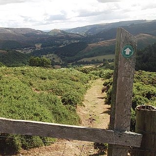
The Dee Valley Way is a Hiking Trail that runs between Corwen and Llangollen in north Wales. The Way is 21 km long. The guide splits it into five sections that are accessible by road.
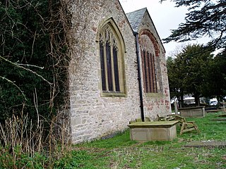
Llanynys is a hamlet and community in Denbighshire, north-east Wales;. It lies in the Vale of Clwyd, a few miles north of Ruthin, and includes the village of Rhewl.
Rhewl may refer to:
Rhewl railway station was a station in Rhewl, Llanynys, Denbighshire, Wales. The station was opened on 1 March 1862 and closed on 30 April 1962. The main station building and sections of the platform are still extant and in use as a private dwelling.
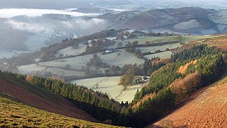
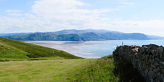
The Clwydian Range and Dee Valley is a designated Area of Outstanding Natural Beauty (AONB) located in north-east Wales, covering the Clwydian Range, and the valley of the River Dee.