Related Research Articles
Denbighshire is a county in the north-east of Wales. Its borders differ from the historic county of the same name. This part of Wales contains the country's oldest known evidence of habitation – Pontnewydd (Bontnewydd-Llanelwy) Palaeolithic site has Neanderthal remains of some 225,000 years ago. Castles include Denbigh, Rhuddlan, Ruthin, Castell Dinas Bran and Bodelwyddan. St Asaph, one of Britain's smallest cities, has one of its smallest Anglican cathedrals.
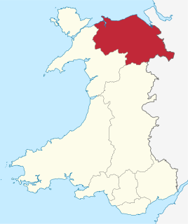
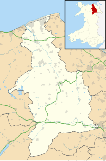
Clwyd is a preserved county of Wales, situated in the north-east corner of the country; it is named after the River Clwyd, which runs through the area. To the north lies the Irish Sea, with the English ceremonial counties of Cheshire to the east and Shropshire to the south-east. Powys and Gwynedd lie to the south and west respectively. Clwyd also shares a maritime boundary with Merseyside along the River Dee. Between 1974 and 1996, a slightly different area had a county council, with local government functions shared with six district councils. In 1996, Clwyd was abolished, and the new principal areas of Conwy County Borough, Denbighshire, Flintshire and Wrexham County Borough were created; under this reorganisation, "Clwyd" became a preserved county, with the name being retained for certain ceremonial functions.

Gwyddelwern is a small village and community of 508 residents, reducing to 500 at the 2011 census, situated approximately 2 miles (3.2 km) north of Corwen in Denbighshire in Wales. Historically the village was part of the Edeyrnion district of Meirionnydd. Edeyrnion was part of the Glyndŵr district of Clwyd from 1974 to 1996, when the area became part of the principal area of Denbighshire. The village straddles the A494 road.

Pingewood is a hamlet in the civil parish of Burghfield, to the south of Reading, in the English county of Berkshire. It lies to the Southwest of Burghfield Bridge The name Pingewood derives from the old Celtic word 'pen' meaning head, peak, tip or end. The 'ge' is a contraction of the Celtic word for wood, 'coed'. When the Saxons moved into the area in the 5th century, they did not understand the meaning and added their own descriptive word 'wood' on the end.
Yale College, Wrexham is now part of Coleg Cambria.

St Giles' Parish Church is the parish church of Wrexham, Wales. The church is recognised as one of the finest examples of ecclesiastical architecture in Wales and is a Grade I listed building, described by Sir Simon Jenkins as 'the glory of the Marches' and by W. D. Caröe as a “glorious masterpiece.”
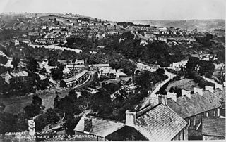
Quakers Yard is a village in the Merthyr Tydfil County Borough, situated where the Taff Bargoed Valley joins the Taff Valley. Quakers Yard is part of the community of Treharris.

Little Chart is a village and civil parish, situated 4 miles (6.4 km) north-west of Ashford in Kent, South East England. The parish lies south of the M20 motorway.

The Eglwyseg valley is an area to the north east of Llangollen in Denbighshire, Wales; it is within the boundaries of Llantysilio Community. The name also refers to a widely scattered hamlet in the valley.

Henryd is a village and community on the western slopes of the Conwy valley in Conwy county borough, north Wales. It lies about 2 miles (3.2 km) south of Conwy, off the B5106 road. At the 2001 census, it had a population of 594, increasing to 715 at the 2011 census.

Rygnestadtunet is an open-air museum at Nordigard farm in northern Rygnestad in the municipality of Valle in Agder county, Norway. It is located in the Setesdal region of Norway, near the junction of the Norwegian National Road 9 and Norwegian County Road 45, about 9 kilometres (5.6 mi) north of the village of Valle. The farm museum today looks exactly as it did when it was deserted in 1919. The farm was legally protected in 1923, it was purchased by the Setesdal Museum in 1938, and it was opened to the public as a museum in 1940. Excavations in the area indicate that the site has been populated since at least 900 AD.

Rhydyronen railway station is a request stop on the Talyllyn Railway, near Tywyn, Gwynedd in mid-Wales. It was built in 1867 to serve local farms, and the village of Bryn-crug.

Bow Street is a large village in the Tirymynach district of Ceredigion, Wales, approximately 3.5 miles (5.6 km) north-east of Aberystwyth. As well as Bow Street itself, it is now often considered to include the neighbouring smaller village of Pen-y-garn and the hamlet of Rhydypennau. All three places stretch in a long narrow strip along the main Aberystwyth to Machynlleth road, the A487.
The name Rhyd-y-gors or Rhydygors has been associated with two historic sites near the market town of Carmarthen in Southwest Wales. The first was the Norman Rhyd-y-gors Castle and the other was Rhyd-y-gors Mansion, home of the Edwardes family.

Hafod Elwy Moor National Nature Reserve, located in the moorland above the town of Denbigh in Denbighshire, North Wales, is part of the Mynydd Hiraethog Site of Special Scientific Interest, formerly managed by the Countryside Council for Wales and now under the jurisdiction of Natural Resources Wales. Established in 1999, it comprises an 82-hectare (200-acre) patch of upland moor lying between the lakes of Llyn Brenig and Llyn Alwen. A conifer forest planted by the Forestry Commission borders the moor to the south and east.

Onesacre Hall is a Grade II* Listed building situated in the rural outskirts of the City of Sheffield in South Yorkshire, England. The hall is located on Green Lane in the small hamlet of Onesacre in the suburb of Oughtibridge, 5 miles (8.5 km) north west of the city centre.

Graianrhyd, also spelt Graeanrhyd, is a small, scattered village in the community of Llanarmon-yn-Iâl, Denbighshire, Wales, lying in hilly limestone country around 2 miles (3.2 km) to the east of Llanarmon-yn-Iâl village, and just to the south of Eryrys.
Llanddulas and Rhyd-y-foel is a community in Conwy County Borough, in Wales. It is located on the coast of Liverpool Bay, at the mouth of the Afon Dulas, 2.7 miles (4.3 km) west of Abergele, 3.6 miles (5.8 km) east of Colwyn Bay and 9.0 miles (14.5 km) east of Conwy. As the name suggests, it consists of the villages of Llanddulas and Rhyd-y-foel. At the 2001 census the community had a population of 1,572, reducing slightly to 1,542 at the 2011 census.

Holdworth is a small rural hamlet situated within the boundary of the City of Sheffield, England. It is located 4.7 miles (7.5 km) northwest of the city centre at an altitude of 280 metres above sea level, giving it extensive views south over the upper Loxley valley. The hamlet falls within the Stannington ward of the City. It is an ancient farming settlement which was mentioned in the Domesday Book of 1086.
Talsarn is a hamlet in the community of Nantcwnlle, Ceredigion, Wales. It lies some 16 miles (26 km) south of Aberystwyth, 64 miles (103 km) north-west of Cardiff, and 178 miles (286 km) from London. It is situated almost half-way between the towns of Lampeter and Aberaeron on the Ceredigion coast. The River Aeron passes close to Talsarn as it makes its way to the sea at Aberaeron.
References
- ↑ "Listed Buildings in Denbighshire" . Retrieved 21 May 2014.