The Rocky Mountains, also known as the Rockies, are a major mountain range in western North America. The Rocky Mountains stretch 3,000 km (1,900 mi) in straight-line distance from the northernmost part of British Columbia, in western Canada, to New Mexico in the Southwestern United States. Located within the North American Cordillera, the Rockies are distinct from the Pacific Coast Ranges, Cascade Range, and the Sierra Nevada, which all lie farther to the west.

The Canadian Rockies or Canadian Rocky Mountains comprise the Canadian segment of the North American Rocky Mountains. They are the eastern part of the Canadian Cordillera, which is a system of multiple ranges of mountains which runs from the Canadian Prairies to the Pacific Coast. The Canadian Rockies mountain system comprises the southeastern part of this system, lying between the Interior Plains of Alberta and northeastern British Columbia on the east to the Rocky Mountain Trench of BC on the west. The southern end borders Idaho and Montana of the United States. In geographic terms, the boundary is at the Canada–United States border, but in geological terms it might be considered to be at Marias Pass in northern Montana. The northern end is at the Liard River in northern British Columbia.

Dawson Creek is a city in northeastern British Columbia, Canada. The municipality of 24.37 square kilometres (9.41 sq mi) had a population of 12,978 in 2016. Dawson Creek derives its name from the creek of the same name that runs through the community. The creek was named after George Mercer Dawson by a member of his land survey team when they passed through the area in August 1879. Once a small farming community, Dawson Creek became a regional centre after the western terminus of the Northern Alberta Railways was extended there in 1932. The community grew rapidly in 1942 as the US Army used the rail terminus as a transshipment point during construction of the Alaska Highway. In the 1950s, the city was connected to the interior of British Columbia via a highway and railway through the Rocky Mountains. Since the 1960s, growth has slowed.

Radium Hot Springs, informally and commonly called Radium, is a village of 776 residents situated in the East Kootenay region of British Columbia. The village is named for the hot springs located in the nearby Kootenay National Park. From Banff, Alberta, it is accessible via Highway 93.

Fort Nelson is a community in northeast British Columbia, Canada within the Northern Rockies Regional Municipality (NRRM). It held town status prior to February 6, 2009 when it amalgamated with the former Northern Rockies Regional District to form the NRRM, becoming its administrative centre. The NRRM is the first regional municipality in the province.

Watson Lake is a town in Yukon, Canada located at mile 635 on the Alaska Highway close to the British Columbia border. The Canada 2016 Census put the population at 790, a drop of 1.5% from 802 in 2011. The town is named for Frank Watson, an American-born trapper and prospector, who settled in the area at the end of the nineteenth century.
The Peace River Regional District is a regional district in northeastern British Columbia, Canada. The regional district comprises seven municipalities and four electoral areas. Its member municipalities are the cities of Fort St. John and Dawson Creek, the district municipalities of Tumbler Ridge, Chetwynd, Taylor, and Hudson's Hope, and the village of Pouce Coupe. The district's administrative offices are in Dawson Creek.
The Kaska or Kaska Dena are a First Nations people of the Athabaskan-speaking ethnolinguistic group living mainly in northern British Columbia and the southeastern Yukon in Canada. The Kaska language originally spoken by the Kaska is an Athabaskan language.

The Northern Rockies Regional Municipality (NRRM), formerly the Northern Rockies Regional District (NRRD), and before that the Fort Nelson-Liard Regional District, is a municipality in northeastern British Columbia, Canada. Although portrayed as a regional municipality in its official name, it is actually classified as a district municipality. The NRRM's offices are located in Fort Nelson, formerly an incorporated town that amalgamated with the NRRD on February 6, 2009 to form the NRRM. With the Peace River Regional District as the southern part, it was the northern part of the Peace River-Liard Regional District, which was split into two on October 31, 1987.
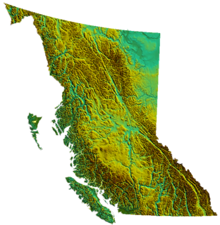
British Columbia is the westernmost province of Canada, bordered by the Pacific Ocean. With an area of 944,735 square kilometres (364,764 sq mi) it is Canada's third-largest province. The province is almost four times the size of United Kingdom, two and one-half times larger than Japan and larger than every U.S. state except Alaska. It is bounded on the northwest by the U.S. state of Alaska, directly north by Yukon and the Northwest Territories, on the east by Alberta, and on the south by the U.S. states of Washington, Idaho, and Montana. Formerly part of the British Empire, the southern border of British Columbia was established by the 1846 Oregon Treaty. The province is dominated by mountain ranges, among them the Canadian Rockies but dominantly the Coast Mountains, Cassiar Mountains, and the Columbia Mountains. Most of the population is concentrated on the Pacific coast, notably in the area of Vancouver, located on the southwestern tip of the mainland, which is known as the Lower Mainland. It is the most mountainous province of Canada.

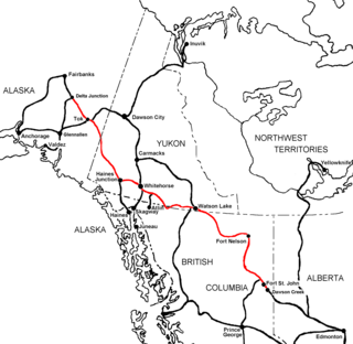
The Rocky Mountain Trench, also known as the Valley of a Thousand Peaks or simply the Trench, is a large valley on the western side of the northern part of North America's Rocky Mountains. The Trench is both visually and cartographically a striking physiographic feature extending approximately 1,600 km (1,000 mi) from Flathead Lake, Montana to the Liard River, just south of the British Columbia–Yukon border near Watson Lake, Yukon. The trench bottom is 3–16 km (1.9–9.9 mi) wide and is 600–900 m (2,000–3,000 ft) above sea level. The general orientation of the Trench is an almost straight 150/330° geographic north vector and has become convenient as a visual guide for aviators heading north or south.

Muncho Lake is a lake in northern British Columbia, Canada.

Toad River, originally Toad's River Post, is a highway service community in northern British Columbia, Canada, located at historic Mile 422 on Highway 97, the Alaska Highway, near the confluence of the Toad and Racing Rivers. The community primarily serves travelers and tourists with a highway maintenance station; a lodge with a restaurant, campground and gas station; a public telephone and a private 3000 foot airstrip. The Toad River Lodge boasts a "world famous" collection of over 10,000 hats (2016) thumbtacked to the ceiling, many of them donated by passersby on the Alaska Highway. Two miles north, The Poplars Campground offers camping, and motel rooms during the summer months (2011).
Scatter River Old Growth Provincial Park is a provincial park in British Columbia, Canada, located on the Liard River downstream from Liard River Hot Springs Provincial Park and Liard River Corridor Provincial Park and Protected Area. The park includes the Grand Canyon of the Liard, a 30km stretch of canyon and whitewater between the Toad and Trout River confluences with the Liard. The park includes high upland plateau and muskeg as well as stands of old growth spruce forests. Established in 1999, the park is c.1140 ha. in area.
Liard River is a river in the Yukon Territory, British Columbia and the Northwest Territories, Canada. The Liard River is an officially named Grand Canyon.
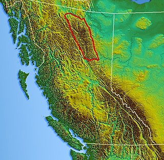
The Northern Rocky Mountains, usually referred to as the Northern Rockies, are a subdivision of the Canadian Rockies comprising the northern half of the Canadian segment of the Rocky Mountains. While their northward limit is easily defined as the Liard River, which is the northward terminus of the whole Rockies, the southward limit is debatable, although the area of Mount Ovington and Monkman Pass is mentioned in some sources, as south from there are the Continental Ranges, which are the main spine of the Rockies forming the boundary between British Columbia and Alberta. Some use the term to mean only the area north of Lake Williston, and in reference to Northern Rocky Mountains Provincial Park, while others consider the term to extend all the way south, beyond the limit of the Hart Ranges at Mount Ovington, to McBride and Mount Robson.
The Toad River is a river in the Canadian province of British Columbia.