Light Oak, North Carolina

Last updated

Light Oak, North Carolina
USA North Carolina location map.svg
Red pog.svg
Light Oak
Location within the state of North Carolina
Coordinates: 35°17′12″N81°28′39″W / 35.28667°N 81.47750°W / 35.28667; -81.47750
Country United States
State North Carolina
County Cleveland
Area
[1]
  Total1.44 sq mi (3.72 km2)
  Land1.44 sq mi (3.72 km2)
  Water0.00 sq mi (0.00 km2)
Elevation
[2]
837 ft (255 m)
Population
 (2020)
  Total697
  Density485.04/sq mi (187.22/km2)
Time zone UTC-5 (Eastern (EST))
  Summer (DST) UTC-4 (EDT)
FIPS code 37-38170 [3]
GNIS feature ID2403232 [2]

Light Oak is an unincorporated area and census-designated place (CDP) in Cleveland County, North Carolina, United States. The population was 691 at the 2010 census. [4]

Contents

Geography

Light Oak is located in southeastern Cleveland County and is bordered on the west and south by the city of Shelby, the Cleveland County seat.

According to the United States Census Bureau, the CDP has a total area of 1.4 square miles (3.7 km2), all land. [4]

Demographics

Historical population
CensusPop.Note
2020 697
U.S. Decennial Census [5]

2020 census

Light Oak racial composition [6]
RaceNumberPercentage
White (non-Hispanic)16323.39%
Black or African American (non-Hispanic)49270.59%
Asian 10.14%
Other/Mixed 304.3%
Hispanic or Latino 111.58%

As of the 2020 United States census, there were 697 people, 388 households, and 218 families residing in the CDP.

2000 census

As of the census [3] of 2000, there were 779 people, 240 households, and 191 families residing in the CDP. The population density was 518.2 inhabitants per square mile (200.1/km2). There were 255 housing units at an average density of 169.6 per square mile (65.5/km2). The racial makeup of the CDP was 16.94% White, 82.16% African American, 0.13% Native American, 0.51% Asian, and 0.26% from two or more races.

There were 240 households, out of which 23.3% had children under the age of 18 living with them, 45.0% were married couples living together, 27.9% had a female householder with no husband present, and 20.4% were non-families. 17.5% of all households were made up of individuals, and 7.1% had someone living alone who was 65 years of age or older. The average household size was 2.85 and the average family size was 3.24.

In the CDP, the population was spread out, with 23.6% under the age of 18, 9.9% from 18 to 24, 27.3% from 25 to 44, 27.6% from 45 to 64, and 11.6% who were 65 years of age or older. The median age was 36 years. For every 100 females, there were 111.7 males. For every 100 females age 18 and over, there were 109.5 males.

The median income for a household in the CDP was $28,472, and the median income for a family was $32,794. Males had a median income of $20,550 versus $16,989 for females. The per capita income for the CDP was $13,016. About 20.7% of families and 17.1% of the population were below the poverty line, including 15.3% of those under age 18 and 51.9% of those age 65 or over.

Related Research Articles

<span class="mw-page-title-main">Cleveland, Florida</span> Census-designated place in Florida, United States

Cleveland is a census-designated place (CDP) in Charlotte County, Florida, United States. The population was 3,435 at the 2020 census. It is part of the Sarasota-Bradenton-Punta Gorda Combined Statistical Area.

<span class="mw-page-title-main">Willow Oak, Florida</span> Census-designated place in Florida, United States

Willow Oak is a census-designated place (CDP) in western Polk County, Florida, United States. The population was 4,917 at the 2000 census. It is part of the Lakeland–Winter Haven Metropolitan Statistical Area.

<span class="mw-page-title-main">Oak Park, Indiana</span> CDP in Indiana, United States

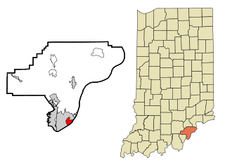
Oak Park is a census-designated place (CDP) in Clark County, Indiana, United States. The population was 5,379 at the 2000 census.

<span class="mw-page-title-main">Woodlawn, North Carolina</span> Census-designated place in North Carolina, United States

Woodlawn is a census-designated place in Alamance County, North Carolina, United States.

<span class="mw-page-title-main">White Oak, North Carolina</span> Census-designated place in North Carolina, United States

White Oak is a census-designated place (CDP) in Bladen County, North Carolina, United States. The population was 338 at the 2010 census.

<span class="mw-page-title-main">St. Stephens, North Carolina</span> Census-designated place in North Carolina, United States

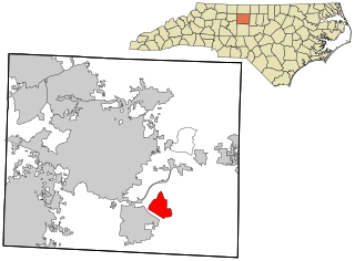
St. Stephens is a census-designated place (CDP) in Catawba County, North Carolina, United States. The population was 8,759 at the 2010 census, down from 9,439 in 2000. It is part of the Hickory–Lenoir–Morganton Metropolitan Statistical Area.

<span class="mw-page-title-main">Forest Oaks, North Carolina</span> Census-designated place in North Carolina, United States

Forest Oaks is a census-designated place (CDP) in Guilford County, North Carolina, United States. The population was 3,890 as of the 2010 census, up from 3,241 in 2000.

<span class="mw-page-title-main">Half Moon, North Carolina</span> CDP in North Carolina, United States

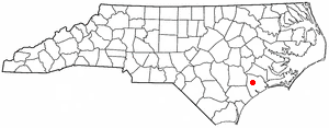
Half Moon is a census-designated place (CDP) in Onslow County, North Carolina, United States. The population was 6,645 at the 2000 census. It is part of the Jacksonville, North Carolina Metropolitan Statistical Area.

Elrod is a census-designated place (CDP) in Robeson County, North Carolina, United States. The population was 441 at the 2000 census.

Raemon is a census-designated place (CDP) in Robeson County, North Carolina, United States. The population was 212 at the 2000 census.

Bonnetsville is a census-designated place (CDP) in Sampson County, North Carolina, United States. The population was 390 at the 2000 census.

<span class="mw-page-title-main">Pin Oak Acres, Oklahoma</span> CDP in Oklahoma, United States

Pin Oak Acres is a census-designated place (CDP) in Mayes County, Oklahoma, United States. The population was 427 at the 2000 census.

<span class="mw-page-title-main">Oak Hills, Pennsylvania</span> Census-designated place in Pennsylvania, United States

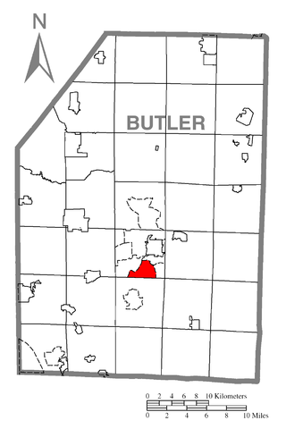
Oak Hills is a census-designated place (CDP) in Butler County, Pennsylvania, United States. The population was 2,333 at the 2010 census.

<span class="mw-page-title-main">Berea, South Carolina</span> CDP in South Carolina, United States

Berea is a census-designated place (CDP) in Greenville County, South Carolina, United States. The population was 14,295 at the 2010 census. It is part of the Greenville–Mauldin–Easley Metropolitan Statistical Area.

<span class="mw-page-title-main">Little River, South Carolina</span> CDP in South Carolina, United States

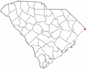
Little River is a census-designated place (CDP) in Horry County, South Carolina, United States. The population was 11,711 at the 2020 census.

<span class="mw-page-title-main">Oak Grove, South Carolina</span> Census-designated place in South Carolina, United States

Oak Grove is a census-designated place (CDP) in Lexington County, South Carolina, United States. The population was 10,291 at the 2010 census. It is part of the Columbia Metropolitan Statistical Area.

Seven Oaks is a census-designated place (CDP) in Lexington County, South Carolina, United States, 8 miles (13 km) northwest of downtown Columbia, the state capital. The population of the CDP was 15,144 at the 2010 census. It is part of the Columbia Metropolitan Statistical Area.

Shiloh is a census-designated place (CDP) in Sumter County, South Carolina, United States. The population was 259 at the 2000 census. It is included in the Sumter, South Carolina Metropolitan Statistical Area.

<span class="mw-page-title-main">India Hook, South Carolina</span> CDP in South Carolina, United States

India Hook is a census-designated place (CDP) in York County, South Carolina, United States. The majority of India Hook is annexed into the city of Rock Hill, but as of 2010 India Hook is still considered to be a CDP. It is one of the three communities located on Lake Wylie.

<span class="mw-page-title-main">Oak Hill, Maine</span> Census-designated place in Maine, United States

Oak Hill is a census-designated place (CDP) in the town of Scarborough in Cumberland County, Maine, United States. Prior to the 2020 census, the CDP was known as Scarborough. The population was 4,403 at the 2010 census. It is part of the Portland–South Portland–Biddeford, Maine Metropolitan Statistical Area.

References

  1. "ArcGIS REST Services Directory". United States Census Bureau. Retrieved September 20, 2022.
  2. 1 2 U.S. Geological Survey Geographic Names Information System: Light Oak, North Carolina
  3. 1 2 "U.S. Census website". United States Census Bureau . Retrieved January 31, 2008.
  4. 1 2 "Geographic Identifiers: 2010 Demographic Profile Data (G001): Light Oak CDP, North Carolina". U.S. Census Bureau, American Factfinder. Archived from the original on February 12, 2020. Retrieved December 31, 2014.
  5. "Census of Population and Housing". Census.gov. Retrieved June 4, 2016.
  6. "Explore Census Data". data.census.gov. Retrieved December 21, 2021.