Likouala-aux-Herbes

Last updated
Likouala-aux-Herbes
Likouala-aux-Herbes.png
Mouth of the Likouala-aux-Herbes. Sangha River to the west and Congo River to the east.
Sanghabasinmap.png
Sangha River basin, showing the Likouala-aux-Herbes to the east
Congo physical map.svg
Red pog.svg
Location
Country Republic of the Congo
Department Likouala
Physical characteristics
Mouth Sangha River
  coordinates
0°52′18″S17°08′06″E / 0.8717°S 17.135°E / -0.8717; 17.135 Coordinates: 0°52′18″S17°08′06″E / 0.8717°S 17.135°E / -0.8717; 17.135
Lengthabout 700 kilometres (430 mi)
Basin size24,800 square kilometres (9,600 sq mi)
Discharge 
  locationBotouali
  average281 cubic metres per second (9,900 cu ft/s)

The Likouala-aux-Herbes is a river in the Republic of the Congo. It is a tributary of the Sangha River, which in turn is a tributary of the Congo River. It gives its name to the Likouala Department.

Contents

Location

The Likouala-aux-Herbes is almost 700 kilometres (430 mi) long [lower-alpha 1] and is the main tributary of the Sangha River. [2] The lower Sangha, the Likouala-aux-Herbes and Likouala-Mossaka rivers flow through the Congolese Cuvette, a huge depression. [3] The soil of this region is sand or clay Quaternary fluvial alluvia. [3] The Likouala aux Herbes basin is located on the predominantly sandy Quaternary formations of the Congolese basin. [4]

The course of the Likouala meanders and shifts over time. [2] The coefficient of sinuosity is more than 1.5 in the upper section, around 2.0 in the middle section and in the lower section as high as 2.8. [5] The lower sections of the Sangha and Likouala-aux-Herbes flow through flat land with little difference in elevation between the two rivers. Part of the lower section of the Sangha River divides into two meandering channels, which then recombine. Further down, a "canal" connects the Sangha and Likouala-aux-Herbes some distance above the main confluence of the two rivers. [6] Not long ago the Likouala-aux-Herbes joined the Sangha 130 kilometres (81 mi) upstream from the present confluence. [2]

Hydrology

Between 1951 and 1993 annual rainfall in the Likouala-aux-Herbes basin was 1,714 millimetres (67.5 in) and average discharge at the Botouali gauging station was 281 cubic metres per second (9,900 cu ft/s). [7] The basin above this point covered 24,800 square kilometres (9,600 sq mi). [8]

Ecology

The Congolese Cuvette has an equatorial climate. [3] The waters of the Likouala-aux-Herbes are reddish brown and contain high quantities of humic and fulvic acids. [2] Vegetation in the river basin is dense, humid, shady forest that partly floods during the high water season. [3] The forest around the upper portion opens into a broad grassy plain near Epena, which increases in width further downstream, although in some parts the forest closes in on the river. In the rainy season the river flows over its banks, and it is often practical for a canoe to take a shortcut between two meanders. [1] The river's name, which means "grassy river", derives from the fact that most of its alluvial plain is flooded grassland, dominated by Jardinea congoensis on the flooded banks, and Hyparrhenia diplandra on the drier banks. [2]

People

Epena, on the river bank just east of the Lake Télé Community Reserve, is the headquarters of Epena District. [9] Epena is about 100 kilometres (62 mi) downstream from the river's source. [1] It was extremely isolated until 1989, when a paved road from the regional capital Impfondo was opened. [9] Below Epena the villages along the river include Itanga, Dzeke, Edzama, Bouanela and Ebambe, almost 350 kilometres (220 mi) downstream. [10] From Ebambe down to the Sangha the river meanders for about 300 kilometres (190 mi). [1] In and above Itanga the people speak dialects of the Bomitaba language. [11] Below Epena the Babole people speak dialects of the Dibole language. [12] The local people engage in fishing and in subsistence agriculture on areas of drier ground. [13]

Lake Télé Community Reserve

The Lake Télé Community Reserve covers a large area adjoining the right (west) bank of the upper Likouala-aux-Herbes to the east of Epena. [14] It is a wetland ecosystem, part of the Complexe Transfrontalier Lac Télé - Grands Affluents - Lac Tumba, a transboundary Ramsar site established in June 2017. It includes swamp forest, flooded and wooded savanna and floating prairie. Lac Télé has turbid water with much organic matter, but the rivers are rich in fish. Resident birds include African darters (Anhinga rufa). Mammals include western lowland gorillas, chimpanzees, elephants, buffaloes, duikers and hippopotamuses. [13] In 2008 researchers from the Wildlife Conservation Society counted gorilla nests and estimated about 125,000 gorillas were living there, far more than the worldwide total thought to be alive at that time. [15]

Notes

  1. 700 kilometres (430 mi) long: another source estimates the length at about 750 kilometres (470 mi), including meanders. [1]

Citations

  1. 1 2 3 4 Leich 2009, p. 792.
  2. 1 2 3 4 5 Censier et al. 1995, p. 239.
  3. 1 2 3 4 Laraque et al. 2001, p. 107.
  4. Censier et al. 1995, p. 240.
  5. Censier et al. 1995, p. 242.
  6. Censier et al. 1995, p. 247.
  7. Laraque et al. 2001, p. 113.
  8. Laraque et al. 2001, p. 106.
  9. 1 2 Leich 2009, p. 789.
  10. Leich 2009, p. 791.
  11. Leich 2009, p. 793.
  12. Leich 2009, p. 795.
  13. 1 2 Lac Télé/Likouala-aux-herbes.
  14. Relation: Likouala-aus-Herbes (1188608).
  15. More than 100,000 rare gorillas.

Sources

Related Research Articles

<span class="mw-page-title-main">Congo River</span> River in central Africa

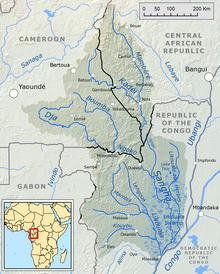
The Congo River, formerly also known as the Zaire River, is the second-longest river in Africa, shorter only than the Nile, as well as the third largest river in the world by discharge volume, following the Amazon and the Ganges rivers. It is also the world's deepest recorded river, with measured depths of around 219.5 m (720 ft). The Congo-Lualaba-Chambeshi River system has an overall length of 4,700 km (2,920 mi), which makes it the world's ninth-longest river. The Chambeshi is a tributary of the Lualaba River, and Lualaba is the name of the Congo River upstream of Boyoma Falls, extending for 1,800 km (1,120 mi).

<span class="mw-page-title-main">Lake Saint Pierre</span> Body of water

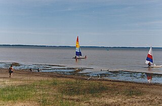
Lake Saint Pierre is a lake in Quebec, Canada, a widening of the Saint Lawrence River between Sorel-Tracy and Trois-Rivières. It is located downstream, and northeast, of Montreal; and upstream, and southwest, of Quebec City. The end of the lake delimits the beginning of the estuary of Saint Lawrence.

<span class="mw-page-title-main">Likouala Department</span> Department of the Republic of the Congo

Likouala is a department of the Republic of the Congo in the northern part of the country. It borders the departments of Cuvette and Sangha, and internationally, the Democratic Republic of the Congo and the Central African Republic. The region has an area of 66,044 km² and an estimated population of almost 90,000. The chief town is Impfondo. Principal cities and towns include Epena and Dongou.

Epena is a village of 2000 people, and seat of Epena District in the Likouala Department of northeastern Republic of the Congo. It is on the Likouala-aux-Herbes river, just east of the Lake Télé Community Reserve.

Lake Tele is a freshwater lake in Epena District, Republic of the Congo.

<span class="mw-page-title-main">Western Congolian swamp forests</span>

The Western Congolian swamp forests are an ecoregion of the Republic of the Congo, Democratic Republic of the Congo and adjoining Central African Republic. Together with the adjacent Eastern Congolian swamp forests, it forms one of the largest continuous areas of freshwater swamp forest in the world. It is a flooded forest with a high canopy, dense undergrowth and has a muddy floor. It has not been disturbed very much by outside influences and so remains largely pristine as getting through this forest is called "almost impossible".

<span class="mw-page-title-main">Wildlife of Cameroon</span>

The wildlife of Cameroon is composed of its flora and fauna. Bordering Nigeria, it is considered one of the wettest parts of Africa and records Africa's second highest concentration of biodiversity. To preserve its wildlife, Cameroon has more than 20 protected reserves comprising national parks, zoos, forest reserves and sanctuaries. The protected areas were first created in the northern region under the colonial administration in 1932; the first two reserves established were Mozogo Gokoro Reserve and the Bénoué Reserve, which was followed by the Waza Reserve on 24 March 1934. The coverage of reserves was initially about 4 percent of the country's area, rising to 12 percent; the administration proposes to cover 30 percent of the land area.

<i>Congo</i> (TV series) British TV series or program

Congo is a 2001 BBC nature documentary series for television on the natural history of the Congo River of Central Africa. In three episodes, the series explores the variety of animals and habitats that are to be found along the river's 4,700 km (2,922 mi) reach.

The Lake Télé Community Reserve is found in the Republic of the Congo. It was established on the 10 May 2001. This site covers 4,389 square kilometres (1,695 sq mi) around Lake Télé. In August 2010, the Cooperation Agreement between the governments of the Republic of the Congo and the Democratic Republic of the Congo (DRC) on the Lake Tele - Lake Tumba landscape provided for creation of a trans-national protected area including the Lake Télé Community Reserve and the Ngiri-Tumba-Maindombe area in the DRC.

<span class="mw-page-title-main">Tumba-Ngiri-Maindombe</span>

Tumba-Ngiri-Maindombe is the largest Wetland of International Importance in the world as recognized by the Ramsar Convention. The site covers an area of 65,696 square kilometres (25,365 sq mi) in the region around Lake Tumba in the western Congo Basin in the Democratic Republic of the Congo (DRC). This is more than twice the size of Belgium or Maryland.

<span class="mw-page-title-main">Aux Rochers River</span> River in Quebec, Canada

Aux Rochers River, is a river in Sept-Rivières Regional County Municipality, Côte-Nord, Quebec, Canada. It drains an area of 4,180 square kilometres (1,610 sq mi). It is a tributary of the Gulf of Saint Lawrence

Lake Mboukou is a freshwater lake in Epena District, Republic of the Congo.

The Schmon River is a river in the Côte-Nord region of the province of Quebec, Canada. It flows south into Lake Walker.

<span class="mw-page-title-main">Pentecôte River</span> River in Quebec, Canada

The Pentecôte River is a river in the Côte-Nord region or the province of Quebec, Canada. It is a tributary of the Gulf of Saint Lawrence, which it enters beside the community of Rivière-Pentecôte.

The Pasteur River is a river in Quebec, Canada, to the north of the lower Saint Lawrence River. It is a tributary of the Aux Rochers River in the Lac-Walker territory of Côte-Nord. For most of its length it flows through the proposed Lake Walker National Park. The lower section of the river includes the 21 kilometres (13 mi) long Lake Pasteur.

The Itimbiri River is a right tributary of the Congo River, which it joins above Bumba. At one time it was important as a navigable waterway for transporting good from the northeast of the country down to the Congo.

<span class="mw-page-title-main">Lobaye River</span> River in Central African Republic

The Lobaye River is a river of the Central African Republic, a right tributary of the Ubangi River.

The 2019–2020 Congo River floods resulted from torrential rains from October 2019 to January 2020 that caused the overflow of the Congo and Ubangi rivers, floods and landslides throughout the Democratic Republic of Congo (DRC) and Republic of Congo (RoC) and led to the displacement of hundreds of thousands of people.

<span class="mw-page-title-main">Likouala-Mossaka</span> River in Republic of the Congo

The Likouala-Mossaka is a river in the Republic of the Congo. It is a tributary of the Congo River, which it enters to the east of the town of Mossaka.