Route 3 is a state highway in the northeastern part of New Jersey. The route runs 10.84 miles (17.45 km) from U.S. Route 46 (US 46) in Clifton, Passaic County, to US 1/9 in North Bergen, Hudson County. The route intersects many major roads, including US 46, which takes travelers to Interstate 80 (I-80) west for commuting out of the city-area, the Garden State Parkway and Route 21 in Clifton, Route 17 and the Western Spur of the New Jersey Turnpike (I-95) in East Rutherford, the Eastern Spur of the New Jersey Turnpike in Secaucus, and Route 495 in North Bergen, for traffic going to the Lincoln Tunnel into New York City. Route 3 serves as the main artery to the Lincoln Tunnel from I-80, in conjunction with a portion of US 46 and Route 495. Portions of the route are not up to freeway standards; with driveways serving businesses and bus stops. Despite this, many construction projects have been underway over the years to alleviate this issue. Route 3 also provided access to Hoffmann La Roche's former American headquarters in Nutley, the Meadowlands Sports Complex and American Dream in East Rutherford. The road inspired a story in The New Yorker in 2004 by Ian Frazier due to its views of the Manhattan skyline. Route 3 was originally the Lincoln Tunnel Approach and ended at the state line in the Hudson River, though it was scaled back following the construction of I-495; which is now Route 495 due to also not meeting interstate highway standards.
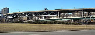
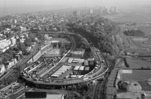
Route 495 is a 3.45-mile-long (5.55 km) state highway in Hudson County, New Jersey, in the United States that connects the New Jersey Turnpike at exits 16E-17 in Secaucus to New York State Route 495 (NY 495) inside the Lincoln Tunnel in Weehawken, providing access to Midtown Manhattan in New York City. The road is owned and operated by the New Jersey Turnpike Authority (NJTA) between the New Jersey Turnpike and Route 3, the New Jersey Department of Transportation (NJDOT) between Route 3 and Park Avenue near the Union City–Weehawken border, and by the Port Authority of New York and New Jersey (PANYNJ) east of Park Avenue, including the helix viaduct used to descend the New Jersey Palisades to reach the entrance of the Lincoln Tunnel. Route 495 is mostly a six-lane freeway with a reversible bus lane used during the morning rush hour. The bus lane, which runs the entire length of the freeway, continues into the Lincoln Tunnel's center tube.

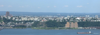
Weehawken is a township in the northern part of Hudson County, in the U.S. state of New Jersey. It is located on the Hudson Waterfront and Hudson Palisades overlooking the Hudson River. As of the 2020 United States census, the township's population was 17,197, an increase of 4,643 (+37.0%) from the 2010 census count of 12,554, which in turn reflected a decline of 947 (−7.0%) from the 13,501 counted in the 2000 census.

The Lincoln Tunnel is an approximately 1.5-mile-long (2.4 km) tunnel under the Hudson River, connecting Weehawken, New Jersey, to the west with Midtown Manhattan in New York City to the east. It carries New Jersey Route 495 on the New Jersey side and unsigned New York State Route 495 on the New York side. It was designed by Ole Singstad and named after Abraham Lincoln. The tunnel consists of three vehicular tubes of varying lengths, with two traffic lanes in each tube. The center tube contains reversible lanes, while the northern and southern tubes exclusively carry westbound and eastbound traffic, respectively.

The Holland Tunnel is a vehicular tunnel under the Hudson River that connects Hudson Square and Lower Manhattan in New York City in the east to Jersey City, New Jersey in the west. The tunnel is operated by the Port Authority of New York and New Jersey and carries Interstate 78. The New Jersey side of the tunnel is the eastern terminus of New Jersey Route 139. The Holland Tunnel is one of three vehicular crossings between Manhattan and New Jersey; the two others are the Lincoln Tunnel and George Washington Bridge.

Route 139 is a state highway in Jersey City, New Jersey in the United States that heads east from the Pulaski Skyway over Tonnele Circle to the state line with New Jersey and New York in the Holland Tunnel, which is under the Hudson River, to New York City. The western portion of the route is a two-level highway that is charted by the New Jersey Department of Transportation (NJDOT) as two separate roadways: The 1.45-mile (2.33 km) lower roadway (Route 139) between U.S. Route 1/9 (US 1/9) over Tonnele Circle and Interstate 78 (I-78) at Jersey Avenue, and the 0.83-mile (1.34 km) upper roadway running from County Route 501 and ending where it joins the lower highway as part of the 12th Street Viaduct, which ends at Jersey Avenue. The lower roadway is listed on the federal and NJ state registers of historic places since 2005. The eastern 1.32 miles (2.12 km) of the route includes the Holland Tunnel approach that runs concurrent with Interstate 78 on the one-way pair of 12th Street eastbound and 14th Street westbound. Including the concurrency, the total length of Route 139 is 2.77 miles (4.46 km).

The Port Authority Bus Terminal is a bus terminal located in Manhattan in New York City. It is the busiest bus terminal in the world by volume of traffic, serving about 8,000 buses and 225,000 people on an average weekday and more than 65 million people a year.

For the purposes of this article, the Jersey City area extends North to Edgewater, South to Bayonne and includes Kearny Junction and Harrison but not Newark. Many routes east of Newark are listed here.

Lincoln Harbor is a station on the Hudson–Bergen Light Rail (HBLR) located at Waterfront Terrace, north of 19th Street, in Weehawken, New Jersey. The station opened on September 7, 2004. There are two tracks and an island platform.

Route 85, also known as the Hoboken Freeway, was a proposed 7.60-mile-long (12.23 km) limited-access highway in Hudson County and Bergen County, New Jersey. The freeway was planned to begin at an interchange with Interstate 78 near the Holland Tunnel approach in Jersey City, northward through North Bergen on its way to Fort Lee, where the highway would interchange with then-Interstate 80 near the George Washington Bridge.

Weehawken Terminal was the waterfront intermodal terminal on the North River in Weehawken, New Jersey for the New York Central Railroad's West Shore Railroad division, whose route traveled along the west shore of the Hudson River. It opened in 1884 and closed in 1959. The complex contained five ferry slips, sixteen passenger train tracks, car float facilities, and extensive yards. The facility was also used by the New York, Ontario and Western Railway. The terminal was one of five passenger railroad terminals that lined the Hudson Waterfront during the 19th and 20th centuries; the others were located at Hoboken, Pavonia, Exchange Place and Communipaw, with Hoboken being the only one still in use.
Access to the Region's Core (ARC) was a proposed commuter-rail project to increase passenger service capacity on New Jersey Transit (NJT) between Secaucus Junction in New Jersey and Manhattan in New York City. New infrastructure would have included new trackage, a new rail yard, and a tunnel under the Hudson River. A new station adjacent to New York Penn Station was to be constructed as running more trains into the current station was deemed unfeasible. An estimated budget for the project was $8.7 billion. Construction began in mid-2009 and the project was slated for completion in 2018, but it was cancelled in October 2010 by Chris Christie, the governor of New Jersey, who cited the possibility of cost overruns and the state's lack of funds. Six hundred million dollars had been spent on the project. The decision remains controversial.
The Hudson Waterfront is an urban area of northeastern New Jersey along the lower reaches of the Hudson River, the Upper New York Bay and the Kill van Kull. Though the term can specifically mean the shoreline, it is often used to mean the contiguous urban area between the Bayonne Bridge and the George Washington Bridge that is approximately 19 miles (31 km) long. Historically, the region has been known as Bergen Neck, the lower peninsula, and Bergen Hill, lower Hudson Palisades. It has sometimes been called the Gold Coast.

Pershing Road is a road located entirely in Weehawken, New Jersey that travels for 0.42 miles (0.68 km) on the Hudson Palisades between Boulevard East and Weehawken Port Imperial, and carries the designation Hudson County Route 682. At County Route 505, the road meets 48th Street, one of the very few two-way streets in the urban grid of North Hudson, which travels west to Bergenline Avenue and Kennedy Boulevard. It is named for World War I hero John J. Pershing. Earlier names have included Clifton Road, named for the estate on whose land it was located, and Hillside Road, which would speak to its location.

Shippen Street is an east-west street in Weehawken, New Jersey. The eastern terminal, a cobblestone double hairpin turn is listed on the New Jersey Register of Historic Places. Shippen Street was developed at the start of the 20th century as part of the Weehawken Heights, one of the town's residential neighborhoods.

Boulevard East is a two-way, mostly two lane, scenic county road in the municipalities of Weehawken, West New York, Guttenberg and North Bergen in North Hudson, New Jersey. Apart from small sections at either end, the road runs along the crest of the Hudson Palisades, affording it views of the Hudson River and the New York City skyline. Developed at the turn of the 20th century, the residential road is characterized by an eclectic mix of 20th-century architecture, including private homes as well as mid and high-rise apartment buildings, mostly on its western side, with a promenade and parks along its eastern side. It is also the setting for Edward Hopper's 1934 painting East Wind Over Weehawken, which is considered one of his best works.

The George Washington Bridge Plaza, also known as GWB Plaza or Bridge Plaza, is the convergence of roads and highways around the site of the George Washington Bridge toll plaza in Fort Lee, New Jersey, United States. The plaza is located north of and parallel to Fort Lee's Main Street. The surrounding busy area is characterized by a mix of commercial and residential uses and an architectural variety that includes parking lots, strip malls, houses, gas stations, mid-rise office buildings and high-rise condominiums. Just to the east is Fort Lee Historic Park, Palisades Interstate Park and the bridge's western tower.

Palisade Avenue is the name given to a historic road which parallels the eastern crest of Hudson Palisades in northeastern New Jersey. It travels between Jersey City and Fort Lee, passing through Jersey City Heights, North Hudson, and Cliffside Park, with various parts carrying Hudson and Bergen county route designations. The avenue re-aligns itself at several places along its route as it crosses traditional municipal boundaries created in the 19th century. As a primary route running along the top of the Hudson Palisades, many segments offer scenic views of the Hudson River and the New York skyline. Since 2020 there is proposed state legislation to restrict building heights that would rise above the cliffs on the eastern side of Palisade Avenue along the entire corridor from Jersey City to Fort Lee.

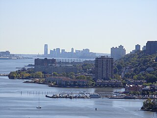
Port Imperial is a community centered around an intermodal transit hub on the Weehawken, New Jersey, waterfront of the Hudson River across from Midtown Manhattan, served by New York Waterway ferries and buses, Hudson–Bergen Light Rail, and NJT buses. The district lies under and at the foot of Pershing Road, a thoroughfare traveling along the face of the Hudson Palisades, which rise to its west. The Hudson River Waterfront Walkway runs along the shoreline and is abutted by recently constructed residential neighborhoods, Lincoln Harbor to the south and Bulls Ferry to the north.
The Lincoln Tunnel Expressway is an eight block-long, mostly four-lane, north–south divided highway between the portals of the Lincoln Tunnel and West 31st Street in Midtown Manhattan in New York City. Dyer Avenue is an at-grade roadway paralleling part of the mostly depressed roadway and serves traffic entering and leaving the highway and the tubes of the tunnel. Like the tunnel, the roads are owned and operated by the Port Authority of New York and New Jersey. They traverse the Manhattan neighborhoods of Hell's Kitchen and Chelsea between Ninth and Tenth avenues. The highway serves as the entrance to the Lincoln Tunnel from Manhattan, with the entrance from Weehawken, New Jersey being the Lincoln Tunnel Helix.