Pymble is a suburb on the Upper North Shore of Sydney in the state of New South Wales, Australia. Pymble is 15 kilometres (9 mi) north of the Sydney Central Business District in the local government area of Ku-ring-gai Council.

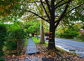
Gordon is a suburb on the Upper North Shore of Sydney in the state of New South Wales, Australia 14 kilometres (9 mi) north-west of the Sydney Central Business District and is the administrative centre for the local government area of Ku-ring-gai Council. East Gordon is a locality within Gordon, and West Gordon is a locality within West Pymble.

Ku-ring-gai Council is a local government area in Northern Sydney, in the state of New South Wales, Australia. The area is named after the Guringai Aboriginal people who were thought to be the traditional owners of the area. More contemporary research suggests that this was not the case.

Warrawee is an affluent suburb on the Upper North Shore of Sydney in the state of New South Wales, Australia. Warrawee is located 17 kilometres north-west of the Sydney Central Business District in the local government area of Ku-ring-gai Council. Warrawee is predominantly a small residential suburb with few commercial entities. Notably, its railway station provides no commercial activity which is uncommon in the Sydney train network.

Wahroonga is an affluent suburb in the Upper North Shore of Sydney, in the state of New South Wales, Australia, 18 kilometres north-west of the Sydney central business district, in the local government areas of Ku-ring-gai Council and Hornsby Shire. North Wahroonga is an adjacent separate suburb of the same postcode.

Turramurra is a suburb on the Upper North Shore of Sydney, in the state of New South Wales, Australia. It is located 16 kilometres (10 mi) north-west of the Sydney central business district, in the local government area of Ku-ring-gai Council. It shares the postcode of 2074 with the adjacent suburbs of North Turramurra, South Turramurra and Warrawee.

Killara is a suburb on the Upper North Shore of Sydney in the state of New South Wales, Australia 14 kilometres (8.7 mi) north-west of the Sydney Central Business District in the local government area of Ku-ring-gai Council. East Killara is a separate suburb and West Killara is a locality within Killara.

Thornleigh is a suburb in the Northern Sydney region, or Upper North Shore of Sydney in the state of New South Wales, Australia. Thornleigh is located 22 kilometres north-west of the Sydney central business district in the local government area of Hornsby Shire. The source of the Lane Cove River is located in Thornleigh.

Berowra is an outer suburb of Northern Sydney located in the state of New South Wales, Australia 36 kilometres north of the Sydney central business district, in the local government area of Hornsby Shire. Berowra is south-east of the suburbs of Berowra Heights and east of Berowra Waters. The name Berowra means place of many shells, referring to the many shell middens on Berowra Creek.
Artarmon is a suburb on the lower North Shore of Sydney, in the state of New South Wales, Australia, 9 kilometres north-west of the Sydney central business district, in the local government area of the City of Willoughby.

Mount Colah is an outer suburb of Northern Sydney, in the state of New South Wales, Australia 29 kilometres north of the Sydney central business district, in the local government area of Hornsby Shire.
Killara High School is a coeducational public secondary school, located on Koola Avenue in East Killara, Sydney. Established in 1968, Killara High School is one of the highest performing comprehensive non-selective public schools in the state. The success of the school in the Higher School Certificate (HSC) and its reputation as a school with an extensive program of curriculum enrichment make the school highly desirable. Activities such as music, art, dance, drama, debating, sport and strong participation in the Duke of Edinburgh's Award Scheme are included in the co-curricular program. Enrolment rose 21% from 2002 to a population of 1400 students in 2009. It now has 1580 students (2016). Currently, accepted catchment areas include Roseville, Lindfield, East Lindfield, West Killara, Killara, East Killara, West Gordon and East Gordon.
West Killara is a locality in the suburb of Killara, a suburb located on the Upper North Shore Sydney, in the state of New South Wales, Australia. It is located 14 kilometres north-west of the Sydney Central Business District in the local government area of Ku-ring-gai Council.

Roseville is a suburb on the Upper North Shore of Sydney in the state of New South Wales, Australia 12 kilometres (7.5 mi) north-west of the Sydney central business district, in the local government areas of Ku-ring-gai and Willoughby. Roseville Chase is a separate suburb to the east.

Mount Kuring-gai is an outer suburb of Northern Sydney, in the state of New South Wales, Australia. Mount Kuring-gai is located 31 kilometres north-west of the Sydney central business district, in the local government area of Hornsby Shire.

East Killara is a suburb on the Upper North Shore of Sydney in the state of New South Wales, Australia. East Killara is located 15 kilometres north of the Sydney Central Business District in the local government area of Ku-ring-gai Council. It is bordered by Garigal national park to the East and Eastern Arterial Rd/ Birdwood Ave to the west. Killara is a separate suburb to the south-west, which shares the postcode of 2071.

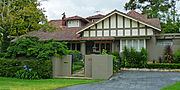
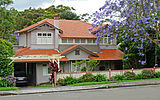
Carlyle Greenwell was an Australian architect whose houses, designed in the first half of the 20th century, are often heritage-listed. He was also a philanthropist who made bequests to the University of Sydney funding research in Anthropology and Archaeology.

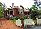
Iolanthe is a heritage-listed former residence and post office located at 691 Pacific Highway in the Sydney suburb of Gordon in the Ku-ring-gai Council local government area of New South Wales, Australia. It was built in 1870. It is also known as Gordon Post Office. The property is owned by the Uniting Church in Australia and is within the perimeter fence of the Ravenswood School for Girls. It was added to the New South Wales State Heritage Register on 2 April 1999.

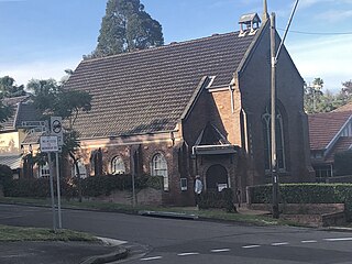
Tryon Road Uniting Church is a heritage-listed Uniting church located at 33 Tryon Road in the Sydney suburb of Lindfield in the Ku-ring-gai Council local government area of New South Wales, Australia. It was designed by William Slade and built from 1914 to 1914 by W. 'Ossie' Knowles. It is also known as Lindfield Wesleyan Methodist Church. The property is owned by the Uniting Church in Australia. It was added to the New South Wales State Heritage Register on 19 September 2003.
Bradfield, the western portion of which was also known as Bradfield Park, was a suburb on the North Shore of Sydney, Australia between 1924 and 1977, since absorbed by neighbouring Lindfield. As of 2021, Bradfield is also the proposed name for a section of Bringelly in South Western Sydney. Both names commemorate Dr John Job Crew Bradfield, who oversaw design and construction of the Sydney Harbour Bridge between 1913 and 1932.

 Lindfield Avenue shops
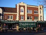
 Pacific Highway shops
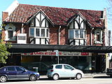 Pacific Highway Tudor revival building
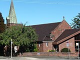 Lindfield Uniting Church