Warrawee, New South Wales

Last updated

Warrawee
Sydney,  New South Wales
(1)Pibrac in Warrawee.jpg
Pibrac, Pibrac Avenue
Warrawee, New South Wales
Population3,170 (2021 census) [1]
 • Density2,440/km2 (6,320/sq mi)
EstablishedEarly 1800s[ citation needed ]
Postcode(s) 2074
Elevation189 m (620 ft)
Area1.3 km2 (0.5 sq mi)
Location16 km (10 mi) north-west of Sydney CBD
LGA(s) Ku-ring-gai Council
State electorate(s) Ku-ring-gai
Federal division(s) Bradfield
Suburbs around Warrawee:
Wahroonga Wahroonga Turramurra
Wahroonga Warrawee Turramurra
Wahroonga Turramurra Turramurra
Warrawee Public School (1)Warrawee Public School-1.jpg
Warrawee Public School
Chauntreys, Heydon Avenue. Chauntreys - a house on Heydon Ave, Warrawee, Sydney, Australia.jpg
Chauntreys, Heydon Avenue.

Warrawee is a suburb on the Upper North Shore of Sydney in the state of New South Wales, Australia. Warrawee is located 17 kilometres north-west of the Sydney Central Business District, in the local government area of Ku-ring-gai Council. [2] Warrawee is predominantly a residential suburb with few commercial entities. Notably, its railway station supports no commercial activities, which is uncommon on the Sydney train network.

Contents

The suburb should not be confused with Wirrawee, the fictional small country town in the Tomorrow series of books for young people by John Marsden, or the film derived from the first book, Tomorrow, When the War Began (2010).

History

The name Warrawee is believed to be an Aboriginal word meaning rest a while, stop here or to stand. [3]

The suburb has a notable architectural history, with a number of houses designed by prominent architects. The earliest significant homes were Pibrac (1888), Cheddington (1890) and Wirepe (1893).

In 1888, the public servant and patron of exploration, Frederick Eccleston Du Faur, built his house Pibrac in Pibrac Avenue. The house was designed by John Horbury Hunt, a Canadian architect who settled in Australia and favoured the Arts and Crafts style, as well as the North American Shingle style, which he introduced to Australia. Later alterations were carried out by B.J. Waterhouse. The house is built predominantly of timber, with extensive use of timber shingles, on a sandstone base. It is considered a good example of Hunt's work and is listed on the Register of the National Estate. [4]

Cheddington, the oldest home in established Hastings Road, is also attributed to Horbury Hunt, constructed in brick, with a slate roof and characteristic shingling. Wirepe, designed by M.B. Halligan for architect Walter Traill, uses deep verandahs and high ceilings to elicit a homestead atmosphere, with fine corbelled chimneys and cedar shingles. The brickwork is laid in colonial bond, and the house sits at the heart of the Ku-ring-gai heritage precinct on Hastings Road.

Upton Grey (now Kooyong) was built in 1894 to a John Sulman design, and its English features are a local landmark. Across the century it has served as a government social services home, a CSIRO field station, and a boarding house for Knox Grammar School. It is now in private hands and retains features replicated at Sulman's important Ingleholme.

Exley House, in Finlay Road, Warrawee, was designed by Harry Seidler in 1957 for Cecil Exley, an engineer with the Sydney Water Board, and his wife. The three-bedroom, two-bathroom home is the only red-brick single-storey dwelling Harry Seidler designed. It has recently been sympathetically extended.

As with all North Shore suburbs with Aboriginal names, Warrawee was the name of a railway station which was then attached to the surrounding suburb. [5] Warrawee developed in the early 20th century as an exclusive residential district, with no shops, offices, post office, public school, churches or through roads. [6] In 1923, Knox Grammar School was founded at Earlston, a Warrawee property across the railway line. All blocks were kept to between 1 and 4 acres (0.4 and 1.6 hectares), and the form of houses was tightly controlled. [6] [7] Joseph Beresford Grant used his money to guarantee the exclusiveness of the development, and also ensured that there were no shops around the area. [6] [8]

Transport

The Pacific Highway is the main arterial road. Warrawee railway station is on the North Shore railway line on the Sydney Trains network. The railway station built in 1900 was the last one built on the North Shore Line before it was extended to North Sydney. Local residents had to fight the railway commissioners for a railway station, that is only one kilometre from Wahroonga.

At the 2021 census, 3.7% of employed people travelled to work on public transport compared to 4.6% average for all of Australia, while 25.5% travelled by car (either as driver or as passenger) compared to 57.8% nationally.

CDC NSW operates one bus route through the suburb of Warrawee:

Demographics

At the 2021 census, the suburb of Warrawee recorded a population of 3,170 people. [1] Of these:

Housing
The majority (84.3%) of private dwellings were family households, 14.7% were single person households and 1.0% were group households. Separate houses accounted for 63.9% of dwellings, while 30.6% were flats or apartments and about 4.7% were semi-detached. [1]

Schools

Warrawee Public School is a primary school situated about 0.5 kilometres to the south of the station in Turramurra, on the Pacific Highway. [10] According to the school's website, it was established in 1906. [11]

Knox Grammar School is predominately in the suburb of Warrawee, and sits no more than 200m from Warrawee railway station. The school lists its address as Wahroonga since the Administration Office is situated within that suburb. [12]

Notable residents

Related Research Articles

<span class="mw-page-title-main">Hornsby, New South Wales</span> Suburb of Sydney, New South Wales, Australia

Hornsby is a suburb on the Upper North Shore of Sydney in the state of New South Wales, Australia, approximately 23 kilometres (14 mi) north-west of the Sydney central business district. It is the administrative centre of the local government area of Hornsby Shire.

<span class="mw-page-title-main">Pymble, New South Wales</span> Suburb of Sydney, New South Wales, Australia

Pymble is a suburb on the Upper North Shore of Sydney in the state of New South Wales, Australia. Pymble is 15 kilometres (9 mi) north of the Sydney central business district in the local government area of Ku-ring-gai Council.

<span class="mw-page-title-main">Ku-ring-gai Council</span> Local government area in New South Wales, Australia

Ku-ring-gai Council is a local government area in Northern Sydney, in the state of New South Wales, Australia. The area is named after a fictional Aboriginal language group.

<span class="mw-page-title-main">St Ives, New South Wales</span> Suburb of Sydney, New South Wales, Australia

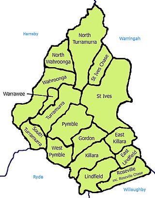
St Ives is a suburb on the Upper North Shore of Sydney in the state of New South Wales, Australia 18 kilometres north of the Sydney Central Business District in the local government area of Ku-ring-gai Council. St Ives Chase is a separate adjacent area, designated suburb, to the west and north.

<span class="mw-page-title-main">North Shore (Sydney)</span> Region in New South Wales, Australia

The North Shore is a region within Northern Sydney, in New South Wales, Australia, generally referring to suburbs located on the northern side of Sydney Harbour up to Wahroonga, and suburbs between Middle Harbour and the Lane Cove River.

<span class="mw-page-title-main">North Shore railway line</span> Railway line in Australia

The North Shore Line is a railway line serving the North Shore in Sydney, New South Wales, Australia. The North Shore Line extends from Sydney Central station through the western limb of the City Circle, across the Sydney Harbour Bridge and through the North Shore area to Hornsby where it joins the Main North Line. Services on the line are primarily provided by the T1 North Shore & Western Line and T9 Northern Line, with some services to Wyong during peak hours.

<span class="mw-page-title-main">Wahroonga, New South Wales</span> Suburb of Sydney, New South Wales, Australia

Wahroonga is a suburb in the Upper North Shore of Sydney, in the state of New South Wales, Australia, 18 kilometres north-west of the Sydney central business district, in the local government areas of Ku-ring-gai Council and Hornsby Shire. North Wahroonga is an adjacent separate suburb of the same postcode.

<span class="mw-page-title-main">Turramurra</span> Suburb of Sydney, New South Wales, Australia

Turramurra is a suburb on the Upper North Shore of Sydney, in the state of New South Wales, Australia. It is located 16 kilometres (10 mi) north-west of the Sydney central business district, in the local government area of Ku-ring-gai Council. It shares the postcode of 2074 with the adjacent suburbs of North Turramurra, South Turramurra and Warrawee.

<span class="mw-page-title-main">Thornleigh, New South Wales</span> Suburb of Sydney, New South Wales, Australia

Thornleigh is a suburb in the Upper North Shore region of Sydney in the state of New South Wales, Australia. Thornleigh is located 22 kilometres north-west of the Sydney central business district in the local government area of Hornsby Shire. The source of the Lane Cove River is located in Thornleigh.

<span class="mw-page-title-main">Turramurra railway station</span> Railway station in Sydney, New South Wales, Australia

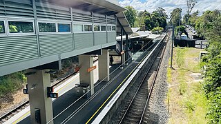
Turramurra railway station is located on the North Shore line, serving the Sydney suburb of Turramurra. It is served by Sydney Trains T1 North Shore line services.

<span class="mw-page-title-main">West Pymble, New South Wales</span> Suburb of Sydney, New South Wales, Australia

West Pymble is a suburb on the Upper North Shore of Sydney in the state of New South Wales, Australia 15 kilometres (9.3 mi) north-west of the Sydney Central Business District in the local government area of Ku-ring-gai Council. Pymble is a separate suburb to the east, sharing the postcode of 2073.

<span class="mw-page-title-main">Wahroonga railway station</span> Railway station in Sydney, New South Wales, Australia

Wahroonga railway station is a heritage-listed railway station located on the North Shore line, serving the Sydney suburb of Wahroonga. The station is located in the Ku-ring-gai Council local government area of New South Wales, Australia. It is served by Sydney Trains T1 North Shore line services. It was built from 1890 to 1910 by E. Pritchard & Co., contractor. It is also known as Wahroonga Railway Station group and Pearce's Corner; Noonan's Platform. The property was added to the New South Wales State Heritage Register on 2 April 1999.

<span class="mw-page-title-main">North Turramurra</span> Suburb of Sydney, New South Wales, Australia

North Turramurra is a suburb on the Upper North Shore of Sydney, in the state of New South Wales, Australia. North Turramurra is located 20 kilometres (12 mi) north-west of the Sydney central business district, in the local government area of Ku-ring-gai Council. Turramurra and South Turramurra are separate suburbs.

<span class="mw-page-title-main">South Turramurra</span> Suburb of Sydney, New South Wales, Australia

South Turramurra is a suburb on the Upper North Shore of Sydney in the state of New South Wales, Australia 18 kilometres (11 mi) north-west of the Sydney central business district, in the local government area of Ku-ring-gai Council. Turramurra and North Turramurra are separate suburbs.

<span class="mw-page-title-main">North Wahroonga, New South Wales</span> Suburb of Sydney, New South Wales, Australia

North Wahroonga is a suburb on the Upper North Shore of Sydney, in the state of New South Wales, Australia. North Wahroonga is located 23 kilometres north-west of the Sydney central business district, in the local government area of Ku-ring-gai Council. Wahroonga is a separate suburb, to the south.

<span class="mw-page-title-main">Electoral district of Ku-ring-gai</span> Former New South Wales electoral district

Ku-ring-gai was an electoral district of the Legislative Assembly in the Australian state of New South Wales. The electorate covers the suburbs and parts of the suburbs of Gordon, Hornsby, Killara, Lindfield, Normanhurst, North Turramurra, North Wahroonga, Pymble, South Turramurra, Thornleigh, Turramurra, Wahroonga, Waitara, Warrawee and West Pymble.

<span class="mw-page-title-main">Olive Fitzhardinge</span> Australian rose breeder

Olive Fitzhardinge (1881–1956) was an Australian rose breeder, the first to patent her work. Her four surviving roses are held in Australian collections. Her roses were well received in the 1930s but after the Second World War favoured styles of roses changed significantly.

Deanes Coaches was an Australian bus company operating route bus services and charter coaches on Sydney's North Shore.

<span class="mw-page-title-main">Eleanor Cullis-Hill</span> Sydney based Australian architect

Eleanor Cullis–Hill was an Australian architect. Running a solo practice from her home between 1946 and 1981, she designed dozens of buildings and renovations, mostly residential, on Sydney's North Shore.

<span class="mw-page-title-main">Electoral district of Wahroonga</span> Australian electorate

Wahroonga is an electoral district of the Legislative Assembly in the Australian state of New South Wales. It was contested for the first time at the 2023 election.

References

  1. 1 2 3 4 5 Australian Bureau of Statistics (28 June 2022). "Warrawee". 2021 Census QuickStats. Retrieved 30 January 2024. OOjs UI icon edit-ltr-progressive.svg
  2. Google (30 January 2024). "Warrawee New South Wales 2074" (Map). Google Maps . Google. Retrieved 30 January 2024.
  3. Pollon, Frances (compiler) (1998). The Book of Sydney Suburbs. North Ryde, N.S.W.: Angus & Robertson. ISBN   0207144958.
  4. The Heritage of Australia, Macmillan Company, 1981, p.2/33
  5. Thorne, Les G.; Jillett, Leslie (1968), North Shore, Sydney from 1788 to today, Angus and Robertson, retrieved 14 October 2012
  6. 1 2 3 Paul Davis, November 2010, Kuring-Gai Potential Heritage Conservation Areas North Review "HCA 23 – Warrawee" retrieved 16 April 2012.
  7. Johnson, John. "North Shore Houses" (PDF). State Library of NSW, compiled for the Upper North Shore Architects' Network and the Institute of Architects. Archived from the original (PDF) on 2 February 2016. Retrieved 25 April 2012. See especially p. 27.
  8. 1 2 "Mr. J. Beresford Grant". The Sydney Morning Herald . National Library of Australia. 28 October 1940. p. 11. Archived from the original on 31 January 2024. Retrieved 7 January 2015 via Trove.
  9. "| transportnsw.info". transportnsw.info. Retrieved 5 May 2024.
  10. Google (30 January 2024). "Warrawee Public School" (Map). Google Maps . Google. Retrieved 30 January 2024.
  11. "About our school". 1486 Pacific Highway Turramurra NSW 2074: Department of Education (New South Wales). Archived from the original on 31 January 2024. Retrieved 31 January 2024 via Warrawee Public School. Warrawee Public School, which has been serving its community since 1906, is proud of its warm, family atmosphere.{{cite web}}: CS1 maint: location (link)
  12. "Contact Us and Location". Knox Grammar School . 2 Borambil Street, Wahroonga NSW 2076, Australia. Archived from the original on 31 January 2024. Retrieved 30 January 2024.{{cite web}}: CS1 maint: location (link)
  13. "Grant, Joseph Beresford". Dictionary of Sydney. Retrieved 7 January 2015.

33°43′30″S151°07′24″E / 33.72500°S 151.12338°E / -33.72500; 151.12338