Linear settlement

Last updated
Some communities along the Saint Lawrence River in Quebec, Canada, developed as linear settlements, as is still clearly seen in Champlain Champlain(Quebec).JPG
Some communities along the Saint Lawrence River in Quebec, Canada, developed as linear settlements, as is still clearly seen in Champlain

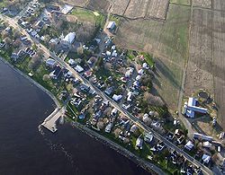
A linear settlement is a (normally small to medium-sized) settlement or group of buildings that is formed in a long line. [1] Many of these settlements are formed along a transport route, such as a road, river, or canal. Others form due to physical restrictions, such as coastlines, mountains, hills or valleys. Linear settlements may have no obvious centre. [2]

Contents

In the case of settlements built along a route, the route predated the settlement, and then the settlement grew along the transport route. Often, it is only a single street with houses on either side of the road. Mileham, Norfolk, England is an example of this pattern. Later development may add side turnings and districts away from the original main street. Places such as Southport, England developed in this way.

A linear settlement is in contrast with ribbon development, which is the outward spread of an existing town along a main street, and with a nucleated settlement, which is a group of buildings clustered around a central point.

A sketch of a street village Wies ulicowka.svg
A sketch of a street village

Particular types of linear settlements are linear village, chain village,[ citation needed ]street village (Polish: ulicówka; [3] German: Straßendorf, [3] Lithuanian: gatvinis kaimas, French: village-rue), and some others. Different countries have various classifications of linear settlements.

Sułoszowa, Poland, is notable for its 9 km long, single main street and its thin strips of farm land, inhabited by 6000 people.

Cities and city districts

Linear designs have also been proposed for new city and district development projects, such as Arturo Soria y Mata's linear city, Michael Graves and Peter Eisenman's linear city, Madrid's Ciudad Lineal district, and Saudi Arabia's The Line. [4] Such designs have been criticized as expressing a simplistic understanding of the process of urban growth and ignoring the human factor in design, resulting in inefficiency and limited growth potential. [5]

See also

Related Research Articles

<span class="mw-page-title-main">Transport in Saudi Arabia</span> Overview of the transport in Saudi Arabia

Transport in Saudi Arabia is facilitated through a relatively young system of roads, railways and seaways. Most of the network started construction after the discovery of oil in the Eastern Province in 1952, with the notable exception of Highway 40, which was built to connect the capital Riyadh to the economically productive Eastern Province, and later to the Islamic holy city of Mecca and the port city of Jeddah. With the economic growth of the 1970s, the Kingdom of Saudi Arabia has initiated many infrastructure development projects across the country, and the extensive development of the transportation network has followed suit in support of various economic developments.

<span class="mw-page-title-main">Riyadh</span> Capital and largest city of Saudi Arabia

Riyadh, formerly known as Hajr al-Yamamah, is the capital and largest city of Saudi Arabia. It is also the capital of the Riyadh Province and the centre of the Riyadh Governorate.

<span class="mw-page-title-main">Transport in Bahrain</span>

Transport in Bahrain encompasses road transportation by car, air transportation and shipping.

<span class="mw-page-title-main">Great Dunmow</span> Human settlement in England

Great Dunmow is a historic market town and civil parish in the Uttlesford district of Essex, England. It lies to the north of the A120 road, approximately midway between Bishop's Stortford and Braintree, 5 mi (8 km) east of London Stansted Airport.

<span class="mw-page-title-main">Ribbon development</span>

Ribbon development refers to the building of houses along the routes of communications radiating from a human settlement. The resulting linear settlements are clearly visible on land use maps and aerial photographs, giving cities and the countryside a particular character. Such development generated great concern in the United Kingdom during the 1920s and the 1930s as well as in numerous other countries during the decades since.

<span class="mw-page-title-main">Aberford</span> Village and civil parish near Leeds, West Yorkshire, England

Aberford is a village and civil parish on the eastern outskirts of the City of Leeds in West Yorkshire, England. It had a population of 1,059 at the 2001 census, increasing to 1,180 at the 2011 Census. It is situated 10 miles (15.5 km) east, north east of Leeds and west of the A1(M) motorway.

<span class="mw-page-title-main">History of Markham, Ontario</span>

The history of Markham, Ontario dates back several millennia. What would become Markham, Ontario was home to First Nations long before European settlement. Seasonal settlements were found from 900 BC to 1650, but traces of these first residence were buried before the area was farmed.

<span class="mw-page-title-main">Wivelsfield</span> Village in East Sussex, England

Wivelsfield village and the larger adjacent village of Wivelsfield Green are the core of the civil parish of Wivelsfield in the Lewes District of East Sussex, England. The villages are 9.3 miles (15.0 km) north of the city of Brighton and Hove.

<span class="mw-page-title-main">Kelvedon</span> Human settlement in England

Kelvedon is a village and civil parish in the Braintree District of Essex in England, between Chelmsford and Colchester. It had a population of 4,717 in 2001, reducing to 3,587 at the 2011 Census. It is now home to several businesses including Knight Group and Lysanda. Brockwell Meadows Local Nature Reserve is south-east of the village between a housing estate and the River Blackwater.

The Reihendorf or Hufendorf is the name used of a particular form of linear settlement in German-speaking countries that is characterized by rows of houses situated along a linear object such as a riverbank, road, valley, or stream.

In January 2004, Deputy Prime Minister John Prescott announced the United Kingdom government's Expansion plans for Milton Keynes. However, the change of government in 2010 and the abolition of the Regional Spatial Strategy in 2012/13 saw these plans revoked and a planned expansion of up to 44,000 dwellings reduced to 28,000. The Milton Keynes Core Strategy was published in July 2013 and regards the figure of 28,000 new homes to be the minimum figure.

<span class="mw-page-title-main">A120 road</span> Road in the east of England

The A120 is an A-road in England, which runs between Puckeridge in Hertfordshire and Harwich in Essex.

Since the early 2000s, Doha, the capital of Qatar has been undergoing an extensive expansion in its transportation network including the addition of new highways, the construction of a new airport, and the under-construction Doha metro. These projects are meant to keep up with the population's rapid growth, which has strained the country's current infrastructure.

<span class="mw-page-title-main">Ribbon farm</span> Long, narrow land divisions for farming

Ribbon farms are long, narrow land divisions for farming, usually lined up along a waterway. In some instances, they line a road.

<span class="mw-page-title-main">Ram Hill</span> Human settlement in England

Ram Hill is a hamlet in the civil parish of Westerleigh and Coalpit Heath, in the South Gloucestershire district, in the ceremonial county of Gloucestershire, England. It is located between Coalpit Heath and Westerleigh and adjoins the hamlet of Henfield immediately to the south. In the Mudge Map 1815, Ram Hill was known as Nutridge Hill, and was linked to Westerleigh by Broad Lane and to Mays Hill by Frog Lane.

The Dammam metropolitan area, or Greater Dammam, is the largest metropolitan area in the Eastern Province of Saudi Arabia. It consists of "The Triplet Cities" of Dammam, Khobar, Dhahran, Qatif and their vicinities. It had a population of 2,190,900 as of the 2022 census. It is known for the arts, pearl culturing, entertainment and popular music and sports legacies. The area includes a variety of natural landscapes, parks, and beaches with a recreational coastline to the Persian Gulf. The Greater Dammam area is also known for being one of the cornerstones of the oil industry with the world's largest oil company and most valuable company, Saudi Aramco, being based in Dhahran, as a result of the first oil well being dug in the area.

The Metro Manila Dream Plan, formally titled the Roadmap for Transport Infrastructure Development for Metro Manila and Its Surrounding Areas, refers to a 2014 integrated plan for improving the transport system in Metro Manila, Philippines, with the hope of turning it into a focal point for addressing Metro Manila's interlinked problems in the areas of transportation, land use, and environment.

The Line is a linear smart city under construction in Saudi Arabia in Neom, Tabuk Province, which is designed to have no cars, streets or carbon emissions. The 170-kilometre-long (110 mi) city is one of the nine announced regions of Neom and is a part of Saudi Vision 2030 project, which Saudi Arabia claims will create around 460,000 jobs and add an estimated $48 billion to the country's GDP. The Line is planned to be the first development of a $500 billion project in Neom. The city's plans anticipate a population of 9 million -- 25% of Saudi Arabia's current population of 35.5 million. Excavation work had started along the entire length of the project by October 2022.

Gladstone–Benaraby Road is a continuous 19.4 kilometres (12.1 mi) road route in the Gladstone region of Queensland, Australia. Much of the route is signed as State Route 58. Gladstone–Benaraby Road is a state-controlled regional road. As part of State Route 58 it provides an alternate route between Benaraby and Mount Larcom. It is also part of the shortest route from Gladstone to the south of the state.

Beaudesert–Beenleigh Road is a continuous 35.5 kilometres (22.1 mi) road route in the Scenic Rim and Logan City regions of Queensland, Australia. Part of the road is signed as State Route 90 and the rest as State Route 92. Beaudesert–Beenleigh Road is a state-controlled road, part district and part regional.

References

  1. English heritage thesaurus Archived 2007-09-14 at the Wayback Machine , 23-05-2013
  2. "Linear settlements". National Grid for Learning Cymru. Archived from the original on 2 December 2008 via Internet Archive.
  3. 1 2 "Poland Population Distribution"
  4. Ravenscroft, Tom (2022-10-19). "Drone footage reveals The Line megacity under construction in Saudi Arabia". Dezeen. Archived from the original on 2022-10-19. Retrieved 2022-11-13.
  5. Hicks, Stewart (2023-01-12), Why Linear Cities Don't Work (5 Reasons) , retrieved 2023-07-04

Further reading