
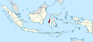
Southeast Sulawesi, is a province on the island of Sulawesi, forming the southeastern peninsula of that island, together with a number of substantial offshore islands such as Buton, Muna, Kabaena and Wawonii, together with many smaller islands. It is bordered by South Sulawesi and Central Sulawesi to the north, sharing a maritime border with Maluku and North Maluku to the east and East Nusa Tenggara to the south, as well a very narrow maritime border with East Timor to the south. The capital is the city of Kendari, on the east coast of the peninsula.
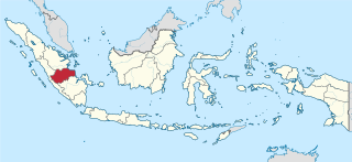
Jambi is a province of Indonesia. It is located on the east coast of central Sumatra and stretches to the Barisan Mountains in the west. Its capital and largest city is also called Jambi. It is bordered by the provinces of Riau to the north, West Sumatra to the west, Bengkulu to the southwest, South Sumatra to the south, and shares a maritime border with the Riau Islands to the east and the Pacific Ocean to the east. The province has a land area of 49,026.58 km2, and a sea area of 3,274.95 km2. It had a population of 3,092,265 according to the 2010 census and 3,548,228 according to the 2020 census; the official estimate of population as of mid-2022 was 3,631,136.

East Nusa Tenggara is the southernmost province of Indonesia. It comprises the eastern portion of the Lesser Sunda Islands, facing the Indian Ocean in the south and the Flores Sea in the north. It consists of more than 500 islands, with the largest ones being Sumba, Flores, and the western part of Timor; the latter shares a land border with the separate nation of East Timor. The province is subdivided into twenty-one regencies and the regency-level city of Kupang, which is the capital and largest city.

West Nusa Tenggara is a province of Indonesia. It comprises the western portion of the Lesser Sunda Islands, with the exception of Bali which is its own province. Mataram, on Lombok, is the capital and largest city of the province. It shares maritime borders with Bali to the west and East Nusa Tenggara to the east. The 2010 census recorded the population at 4,500,212; the total rose to 4,830,118 at the 2015 Intermediate Census and 5,320,092 at the 2020 census; the official estimate as at mid 2022 was 5,473,671. The province's area is 20,153.15 km2. The two largest islands by far in the province are Lombok in the west and the larger Sumbawa island in the east.
West Sulawesi is a province of Indonesia. It borders the provinces of South Sulawesi and Central Sulawesi to the east, Makassar Strait to the west, and the Pacific Ocean to the south. The province also shares maritime borders with East Kalimantan and South Kalimantan to the west and West Nusa Tenggara to the south. It is located on the western side of Sulawesi island. It covers an area of 16,594.75 km2, and its capital is the town of Mamuju. The 2010 Census recorded a population of 1,158,651, while that in 2020 recorded 1,419,228; the official estimate as at mid 2022 was 1,458,606.
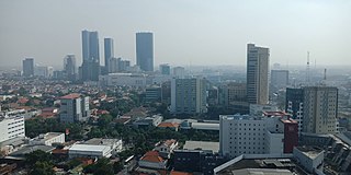
The Surabaya metropolitan area, or known locally as Gerbangkertosusila, is a metropolitan area in East Java, Indonesia. It is the country's second-largest metropolitan area, after Jakarta metropolitan area. Gerbangkertosusila had also been used in presidential decree to refer to larger region which include Jombang, Bojonegoro, and Tuban.

Merauke Regency is a regency in the far south of the Indonesian province of South Papua. It covers an area of 45,025.91 km2, and had a population of 195,716 at the 2010 Census and 230,932 at the 2020 Census; the official estimate as at mid 2022 was 232,357, comprising 121,237 males and 111,120 females. The administrative centre is the town of Merauke; this was projected since 2013 to become an independent city (kota) separate from Merauke Regency, but the alteration has been deferred. It is also the provincial capital of the province of South Papua, more specifically in Salor located in Kurik District. Merauke is the largest regency in Indonesia, with an area of 45,026 km2, slightly larger than Estonia.

Belu Regency is a regency in East Nusa Tenggara province of Indonesia. Situated on the north of Timor island, it adjoins the separate nation of East Timor to the east. Established on 20 December 1958, Belu Regency has its seat (capital) in the large town of Atambua.

Pakpak Bharat Regency is a landlocked regency in North Sumatra, Indonesia. It was created on 25 February 2003 from the southern districts of Dairi Regency. The regency covers an area of 1,218.3 square kilometres and it had a population of 40,481 at the 2010 census and 52,351 at the 2020 Census; the official estimate as at mid 2022 was 54,609. Its seat is the town of Salak. It is the least populated regency in North Sumatra. Its population is roughly the same as Greenland, the island with the lowest population density in the world.

The Bandung Metropolitan Area, officially called the Bandung Basin or Greater Bandung, is a metropolitan area surrounding the city of Bandung, West Java, Indonesia. It was home to about nine million people in mid 2022 and is composed of regencies and cities previously part of the Dutch East Indies era "Central Priangan Residency" administration.

East Lombok Regency is a regency of the Indonesian Province of West Nusa Tenggara. It is located on the island of Lombok, of which it comprises the eastern third ; the administrative capital is the town of Selong. The Regency covers an area of 1,605.55 km2 and had a population of 1,105,582 at the 2010 Census and 1,325,240 at the 2020 Census; the official estimate as at mid 2022 was 1,366,434.

East Flores Regency is a regency in East Nusa Tenggara province of Indonesia. Established in 1958, the regency has its seat (capital) in Larantuka on Flores Island. It covers a land area of 1,812.85 km2, and it had a population of 232,605 as of the 2010 census and 276,896 at the 2020 Census; the official estimate as of mid-2022 was 288,897. The regency encompasses the eastern tip of the island of Flores, together with all of the adjacent islands of Adonara and Solor to the east of Flores, with some much smaller offshore islands. On 4 October 1999, the island of Lembata at the eastern end of the Solor Archipelago was separated from the East Flores Regency to create its own Regency.

Manggarai Regency is a regency in East Nusa Tenggara province of Indonesia, situated on the island of Flores. Established in 1958 the regency was reduced in size and population by the separation of West Manggarai Regency in 2003 and of East Manggarai Regency in 2007. The area of the residual Manggarai Regency is 1,344.03 km2 and its population was 292,037 at the 2010 census and 312,855 at the 2020 census; the official estimate as at mid 2022 was 317,646. The capital of the regency is the town of Ruteng.

Kupang Regency is a regency in East Nusa Tenggara province of Indonesia. It occupies the far western end of Timor Island, together with the small offshore island of Semau. Other islands to the southwest and west which were formerly part of Kupang Regency have been separated administratively - the Rote Islands Group on 10 April 2002, and the Savu Islands on 29 October 2008. The capital of Kupang Regency is at Oelamasi.

Bone Regency is a regency of South Sulawesi, Indonesia. Originally the seat of the Bone state, it joined Indonesia in 1950. The regency covers an area of 4,559.00 km2 and had a population of 717,682 at the 2010 census and 801,775 at the 2020 census the official estimate as at mid 2022 was 813,188. Its main products are seaweed, rice, and fish. The principal town is Watampone, which comprises the three districts of Tanete Riattang Barat, Tanete Riattang and Tanete Riattang Timur within the regency.

The Sangihe Islands Regency is a regency of North Sulawesi Province, Indonesia. It comprises a group of islands situated to the North of Sulawesi. It covers a land area of 736.98 km2, and had a population of 126,100 at the 2010 census and 139,262 at the 2020 census; the official estimate as at mid 2022 was 140,165. The principal island is also named Sangihe, on which lies the main town of Tahuna. Minor island groups within the Regency include the Marore group considerably to the north of Sangihe Island, the Tatoareng group to the south, and the Nusa Tabukan group off the northeast coast of Sangihe Island. It borders the Philippines in the north, making it one of Indonesia's border regions.

Sungai Durian, or "Durian River", is a district of Kotabaru Regency in the province of South Kalimantan, Indonesia. The population is entirely rural.
Simpang Rimba is a district of South Bangka Regency, Bangka-Belitung Islands. It is the fourth largest and third most populated district in the regency, with a population of over 25,000.

Muaradua, or usually spelled as Muara Dua, is a town or Sub-district in South Ogan Komering Ulu Regency, of South Sumatra province of Indonesia and it is the seat (capital) of South Ogan Komering Ulu Regency.