
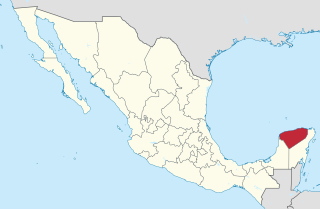
Quintana Roo is a state in southeast Mexico established out of the Quintana Roo Territory in 1974 with seven municipalities, which has since grown into eleven municipalities. According to the 2020 Mexican census, it has the twenty-fourth largest population of all states with 1,857,985 inhabitants and is the 19th largest by land area spanning 44,705.2 square kilometres (17,260.8 sq mi).
Yucatán is a state in southeastern Mexico that is divided into 106 municipalities, organized into 7 administrative regions. According to the 2020 Mexican Census, it is the twenty-second most populated state with 2,320,898 inhabitants and the 20th largest by land area spanning 39,524.4 square kilometres (15,260.5 sq mi).

Tlaxcala is a state in Central Mexico that is divided into 60 municipalities. According to the 2020 Mexican Census, it is the fifth least populated state with 1,342,977 inhabitants and the 2nd smallest by land area spanning 3,996.6 square kilometres (1,543.1 sq mi).
Aguascalientes is a state in North Central Mexico that is divided into eleven municipalities. According to the 2020 Mexican Census, Aguascalientes is the sixth least populous state with 1,425,607 inhabitants and the fourth smallest by land area spanning 5,630.27 square kilometres (2,173.86 sq mi).
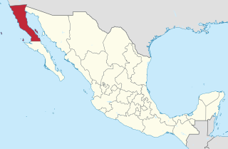
Baja California is a state in Northwest Mexico that is divided into seven municipalities. According to the 2020 Mexican Census, Baja California is the 13th most populous state with 3,769,020 inhabitants and the 12th largest by land area spanning 73,290.08 square kilometres (28,297.46 sq mi).
Mexico City is one of the 32 federal entities of Mexico, the others being the 31 states. It was named Distrito Federal up to February 5, 2016, when it was officially renamed the Ciudad de México. According to the 2020 Mexican Census, it is the second most populated entity with 9,209,944 inhabitants and the smallest by land area spanning 1,494.3 square kilometres (577.0 sq mi).

The 32 federal states of Mexico are ranked below according to population, size, population density, and GDP.
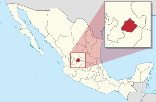
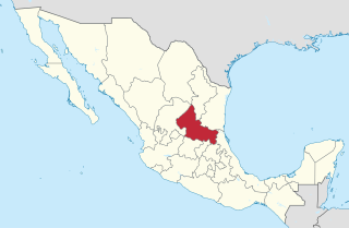
Querétaro is a state in North Central Mexico, divided into 18 municipalities. According to the 2020 Mexican Census, it is the twenty-first most populated state out of thirty-two with 2,368,467 inhabitants and the sixth smallest by land area spanning 11,690.6 square kilometres (4,513.8 sq mi). The largest municipality by population is Querétaro, with 1,049,777 residents, while the smallest is San Joaquín with 8,359 residents. The largest municipality by land area is Cadereyta de Montes, with an area of 1,347.40 km2 (520.23 sq mi), and the smallest is Corregidora with 234.90 km2 (90.70 sq mi). The newest municipalities are Ezequiel Montes, Pedro Escobedo and San Joaquín, established in 1941.

Puebla is a state in central Mexico that is divided into 217 municipalities. According to the 2020 Mexican Census, it is the fifth most populated state with 6,583,278 inhabitants and the 21st largest by land area spanning 34,309.6 square kilometres (13,247.0 sq mi).

Morelos is a state in South Central Mexico that is currently divided into 36 municipalities. According to the 2020 Mexican Census, it is the twenty-third most populated state with 1,971,520 inhabitants and the third smallest by land area spanning 4,878.9 square kilometres (1,883.8 sq mi).
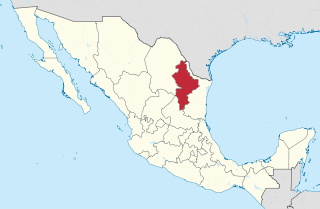
Nuevo León is a state in Northeast Mexico that is divided into 51 municipalities. According to the 2020 Mexican Census, it is the seventh most populated state with 5,784,442 inhabitants and the 13th largest by land area spanning 64,156.2 square kilometres (24,770.8 sq mi).

Zacatecas is a state in North Central Mexico that is divided into 58 municipalities. According to the 2020 Mexican Census, it is the state that has the 7th smallest population with 1,622,138 inhabitants and the 8th largest by land area spanning 75,275.3 square kilometres (29,064.0 sq mi).

Nayarit is a state in West Mexico, divided into twenty municipalities. According to the 2020 Mexican Census, it is the fourth least populated state with 1,235,456 inhabitants and the 23rd largest by land area spanning 27,856.5 square kilometres (10,755.5 sq mi).

Sinaloa is a state in Northwest Mexico that is divided into 18 municipalities. According to the 2020 Mexican Census, it is the seventeenth most populated state with 3,026,943 inhabitants and the eighteenth largest by land area spanning 57,365.4 square kilometres (22,148.9 sq mi).
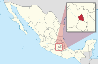
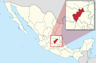
San Luis Potosí is a state in North Central Mexico that is divided into 58 municipalities. According to the 2020 Mexican Census, it is the 19th most populated of Mexico's 31 states, with 2,822,255 inhabitants and the 15th largest by land area spanning 61,138.0 square kilometres (23,605.5 sq mi). The largest municipality by population is the city of San Luis Potosí, with 911,908 residents, while the smallest is Armadillo with 4,013 residents. The largest municipality by land area is Santo Domingo which spans 4,322.60 km2 (1,669.0 sq mi), and the smallest is Huehuetlán with 71.50 km2 (27.61 sq mi). The newest municipalities are El Naranjo, created out of Ciudad del Maíz, and Matlapa, carved from Tamazunchale, both established in 1994.
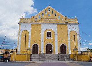
Hunucmá is a town and the municipal seat of the Hunucmá Municipality, Yucatán in Mexico. As of 2020, the town has a population of 28,412.

Region IV is an intrastate region within the State of Mexico. It lies to the north of Mexico City, in the Valley of Mexico, bordering the state of Hidalgo. The whole region is one of the ten in the state which form part of the Metropolitan Area of the Valley of Mexico, although Villa del Carbón is not included in the definition of the metropolitan area.

The Mexico City megalopolis, also known as the Megalopolis of Central Mexico, is a megalopolis containing Greater Mexico City and surrounding metropolitan areas.
