Location: Intersection of U.S. Route 4 and Prescott Hill Road[1]
"Born to a prominent family in Grafton, J. Sarah Barney graduated valedictorian from Boston University with degrees in medicine and surgery in 1896. A founding doctor at Franklin Hospital, where she practiced from 1910 to her retirement, Dr. Barney was remembered for her grit, humor, and involvement with women's suffrage. Upon her death, newspapers called her a pioneer and urged young readers to 'gather a little inspiration from the life of Dr. Barney to face up to the problem of the hour.'"[2]
"In the 19th century this industrial village developed between the Grafton Turnpike and the banks of Mill Brook. East Grafton was once known as Bungtown, a name derived from an accident involving an overturned cart of failed barrel stoppers or 'bungs.' At peak production, one could find shingles, clapboards, cider, harnesses, axes, paint, woolens, bobbins, carriages, and coffins made here, powered by several mill ponds. Today, the carding mill, axe factory, and harness shop still stand."[2]
"Incorporated in 1804, this major highway completed the link between Concord, NH and Boston, MA, improving transportation of goods and personal travel. Granite posts marked many turnpikes, and this one in Salem marked the halfway point between Concord and Boston. The mileposts aided travelers and road maintenance crews. The marker was cemented into the stone wall in the 1940s after road repair. In 1956 the land was donated to the town to preserve memory of the original main route through Salem, NH on Old Rockingham Rd."[3]
Note: Originally installed in 2016 at 43 Old Rockingham Road in Salem, in 2022 the marker was relocated to 73 Old Rockingham Road.[4]
"'The Avenues,' a large neighborhood with small lots, was named for its north-south avenues, 1st to 6th. Housing construction was fueled by the booming paper industry and the arrival of the Berlin Street Railway in 1902. Over the next 30 years, many working-class immigrant families built single and multi-family houses in this ethnically-diverse neighborhood, which included many French-Canadian families, as well as those from Russia, Poland, Ireland, and Italy."[5]:21
"Berlin became known as 'The City that Trees Built' after innovations in the 1870s replaced rags with wood pulp in paper manufacturing. As the paper industry expanded Berlin's population grew from 8,886 in 1900 to 20,018 in 1930. The Brown Company research laboratory, associated with a prominent mill company, held some 500 patents. While pulp, newsprint, and kraft shipping paper were major products, Brown Company manufactured many other wood-based items including chloroform, Kream Krisp shortening, Nibroc paper towels, and Bermico sewer pipes."[3]
"Constructed in 1855 to replace the original station, this is the oldest surviving depot on the former Northern Railroad. First known as 'North Boscawen Depot,' it was renamed in 1909 following a fatal train collision caused by confusion over similar station names, along with several other depots on the line. The name 'Gerrish' was chosen in honor of a prominent farming family. The depot provided freight and passenger service for local farms and residents, the state nursery, the county nursing home, and county jail until 1955."[6][7]
"Here at the Rocks, her family's summer estate, this Chicago heiress pursued her passion for criminology in the 1940s–50s with the creation of 20 miniature dioramas depicting actual crime scenes with detailed accuracy. Called the Nutshell Studies of Unexplained Death, the dioramas were based on crime scene statements and photographs, and were used to train homicide detectives. In recognition of her many contributions to forensic science, Glessner Lee was appointed an honorary Captain of the New Hampshire State Police in 1943."[8][9]
"This small building, built ca. 1820, served as a stopover for a stagecoach route that passed through Danville. Passengers could buy refreshments while the horses rested and carriages were repaired. Early customer accounts remain intact, written on interior walls. Nathaniel Webster, third cousin to Daniel Webster and the town's first U.S. postmaster, ran the post office from this building. The stagecoach stop's history illustrates the importance of 19th century stagecoach culture, not only for travel but also for commerce and mail delivery."[10][11]
"The Town of Nottingham was created by a Royal Charter in 1722. A plan of the town was completed in 1724; at that time the design of the Nottingham Square was laid out with the house lots and the intersecting streets of Bow, Fish, King and North. The town's first school, blockhouse and later meetinghouse were built on this summit. The site of militia drills in 1775 and home to four Revolutionary War generals, Nottingham Square served as the center of the town's business and social life for more than a century and remains common land for all."[12][13]
"Hollis's first settlers of English descent, Capt. Peter Powers and his wife, Anna Keyes, established their homestead on this hill in 1730. An explorer, land surveyor and town officer, Capt. Powers also led the Hollis Company in the 1755 expedition to Crown Point, New York, during the French and Indian War. He and three sons served in the French and Indian War; four sons were soldiers in the Revolutionary War as well. Capt. Powers died of fever in 1757 at age 49, while Anna remained in Hollis until her death in 1798."[14][15]
261. BASIC: The First User-Friendly Computer Programming Language
"In 1964, Dartmouth College math professors John Kemeny and Thomas Kurtz created one of the first user-friendly programming languages, called Beginners All-purpose Symbolic Instruction Code. BASIC made computer programming accessible to college students and, with the later popularity of personal computers, to users everywhere. It became the standard way that people all over the world learned to program computers, and variants of BASIC are still in use today."[16][17]
"Native Charles E. Tilton shaped his hometown through many gifts of monuments, buildings and parks—places that make the community special today. After moving to the West Coast in 1850, Tilton acquired extraordinary wealth through his trading company and investments. The citizens of Sanbornton Bridge voted to name their new town 'Tilton' in his family's honor after NH GovernorOnslow Stearns approved the town's division from Sanbornton June 30, 1869."[18]
"In 1963, an emerging Franconia College purchased the former Forest Hills grand hotel, built on this site in 1882. Bending the norms of higher education, the college offered selfdirected study, and administrative decisions were made by faculty and students at freewheeling community meetings. The experimental school was part of a national trend in progressive education during an era of revolution and change. Faced with mounting financial pressures, it closed its doors in 1978. By 1986 the building was no longer extant."[19]
"New Hampshire lawyer, politician and noted abolitionist, Hale lived in this home for nearly 40 years, until his death. During this time, he was elected to the U.S. Congress as a Democrat in 1842, to the U.S. Senate as an Independent in 1847 and again to the U.S. Senate as a Republican in 1855. The first distinctly anti-slavery U.S. senator, he was friendly with President Lincoln, who named him Minister to Spain in 1865. A statue of Hale joins those of Daniel Webster and Gen. John Stark at the State House in Concord."[20]
"Built in 1803 as the First Baptist Church in the geographic center of town, the Cornish Meetinghouse was moved to the more populated mill and mercantile village of Cornish Flat in 1818. After its move, the belfry was added. Charlestown clockmaker Stephen Hasham's hand wound clock, installed in 1845, still keeps time and strikes the bell that was replaced in 1872. In 1883 the belfry was enclosed and a patterned slate roof was added. The building's exterior reflects architectural details from the Federal, Greek Revival and Queen Anne periods."[14]
"Incorporated in 1814, Pinkerton Academy is the state's largest independent high school and is one of the oldest. Since its founding 'for the purpose of promoting piety and virtue and for the Education of Youth,' notable faculty and alumni include: poet and Pinkerton teacher Robert Frost (1906–11); Alan Shepard (1940), the first American in space; Brian Thacker (1963), who earned the Medal of Honor for his action in the Vietnam War; and Tricia Dunn (1992), who won a gold medal for ice hockey at the 1998 Winter Olympics."[21]
"Southwest of this marker stands Pinkerton Academy's first schoolhouse. It was built in 1815 through efforts of trustees John Porter and brothers John and James Pinkerton. The building opened its doors on Dec. 4, 1815 and, by June 1816, Pinkerton's enrollment consisted of 44 boys and 27 girls from N.H. and surrounding states. Moved from its original site in 1886, the Old Academy Building survives as Pinkerton's only original structure. It has served many functions, such as the home of the Alumni Association and the school's archives."[22]
"Built in 1803–1804, the Abbot-Spalding House exemplifies the Federal and Colonial Revival styles of architecture in Nashua, with the interior featuring fine woodwork and cabinetry. Daniel Abbot, the 'Father of Nashua,' and his family were the original residents. William Spalding, a noted banker and antique dealer, and his family were the last residents. Spalding and his cabinetmaker son, Dexter, updated the residence with Colonial Revival detailing in the early 20th century. The house was acquired by the Nashua Historical Society in 1978."[14]
Location: Centennial Park (NH 101A at Union Street)[1]
"In 1929, Manchester native Bernice Blake Perry became the first woman in New Hampshire to pilot a plane and the first female commercial pilot in New England. She spent her adult life in Milford and was a charter member of the Ninety-Nines, a pioneering group of female pilots led by Amelia Earhart. Perry became known in the 1930s for her aerial photography, including site mapping to help develop airports in New Hampshire. A member of the Blake’s Restaurant family, she was also a well-known philanthropist in the region."[23][24]
"A resident of Bristol, E. Maude Ferguson was widely admired for her community service. A member of the League of Women Voters, she won election to the NH House of Representatives six years after women secured the vote. In 1930, after two terms in the House, she became the first woman elected to the NH State Senate, having been endorsed by both Republicans and Democrats. A trained elocutionist, she served on the Judiciary Committee and chaired the State Library Committee during her terms in Concord."[26]
"A gift of three acres atop Pack Monadnock in 1891 for use as a 'park or pleasure-ground,' Miller State Park has grown to more than 530 acres. 'Pack,' an ancient Abenaki word meaning 'small,' contrasts its summit with nearby Mount Monadnock. The site has included a 'mountain highway,' two different hotels that each succumbed to fire, and a fire look-out tower built by the Civilian Conservation Corps in the 1930s. The park is named for Peterborough native Gen. James Miller."[27][28]
"Beginning in 1890, Fresh Pond Ice Company operated on the eastern shore of Lake Potanipo.[lower-alpha 16] The first ice harvest was shipped to Boston for local distribution in 1892 on Brookline’s newly complete railroad. At its peak of operation, the company employed more than 250 people and harvested more than 100,000 tons of ice annually in 13 icehouses. The advent of electric refrigeration, coupled with a fire that destroyed the extensive complex of icehouses on March 22, 1935,[lower-alpha 17] effectively ended commercial ice harvesting at this location."[30][31]
"After establishing a fishing settlement in what is now called Dover Point, Edward Hilton, Sr. (1569–1671) settled in the 'New fields' section of Exeter in the 1630s. Hilton’s first know residence was located near the Hilton Burying Ground, where many of his descendants are buried. The oldest surviving inscription is for his grandson, Col. Winthrop Hilton (1671–1710), who was the principal military commander in New Hampshire at the time of his death. A Hilton family home built in the early 18th century stands on what is now Exeter Road."[32][33]
Location: Northwest corner of NH 156 junction with NH 27[1]
"In 1930, while living in Raymond, Frank J. Mafera patented a method of forming wire fence fabric that was appealing for residential use as it was safer and more attractive, yet still strong. Prior to this innovation, chain link fencing was woven in a way that left ‘ragged or unsightly’ twists or barbs. Mafera’s technique produced a closed, rounded configuration that is still used in the manufacturing of some chain link fencing. This fence style was first sold at Mafera’s Barnyard Fence Company in Raymond, which later became the New Hampshire Fence Company."[34]
Location: Southwest corner of Swain Hill Road junction with NH 25[1]
"Three-year-old Sarah Whitcher became lost in these woods in June 1783 while gathering flowers. During a four-day search, Sarah’s footprints were found near Berry Brook alongside bear prints. A local man joined the search after dreaming three times that 'Sarah would be found under a pine bough near Berry Brook guarded by a bear.' His dream proved to be true: Sarah was found as he stated and she told her rescuers that 'A great black dog had kept her each night.' The lore of this little girl saved by a bear has entertained generations of people and inspired several children’s books."[38]
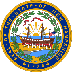
New Hampshire is a state in the New England region of the Northeastern United States. It borders Massachusetts to the south, Vermont to the west, Maine and the Gulf of Maine to the east, and the Canadian province of Quebec to the north. Of the 50 U.S. states, New Hampshire is the fifth smallest by area and the tenth least populous, with a population of 1,377,529 residents as of the 2020 census. Concord is the state capital and Manchester is the most populous city. New Hampshire's motto, "Live Free or Die", reflects its role in the American Revolutionary War; its nickname, "The Granite State", refers to its extensive granite formations and quarries. It is well known nationwide for holding the first primary in the U.S. presidential election cycle, and for its resulting influence on American electoral politics.
Candia is a town in Rockingham County, New Hampshire, United States. The population was 4,013 at the 2020 census. The town includes the villages of Candia, Candia Four Corners and East Candia.
The White Mountains Region is a tourism region designated by the New Hampshire Division of Travel and Tourism. It is located in northern New Hampshire in the United States and is named for the White Mountains, which cover most of the region. The southern boundary of the region begins at Piermont on the west, and runs east to Campton, then on to Conway and the Maine border. The northern boundary begins at Littleton and runs east to Gorham and the Maine border. The region to the north is known as the Great North Woods Region, which should not be confused with the larger and more general Great North Woods.
The U.S. state of New Hampshire has, since 1958, placed historical markers at locations that are deemed significant to New Hampshire history. The New Hampshire Division of Historical Resources (DHR) and the Department of Transportation (DOT) are jointly responsible for the historical marker program. The program is authorized by RSA 227 C:4, X, and RSA 236:40 to 44. As of November 2023, DHR has installed 288 markers, although several have been retired or refurbished.
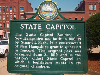
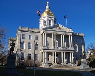
The New Hampshire State House, located in Concord at 107 North Main Street, is the state capitol building of New Hampshire. The capitol houses the New Hampshire General Court, Governor, and Executive Council. The building was constructed on a block framed by Park Street to the north, Main Street to the east, Capitol Street to the south, and North State Street to the west.
Franconia College was a small experimental liberal arts college in Franconia, New Hampshire, United States. It opened in 1963 in Dow Academy and the site of the Forest Hills Hotel on Agassiz Road, and closed in 1978, after years of declining enrollment and increasing financial difficulties.
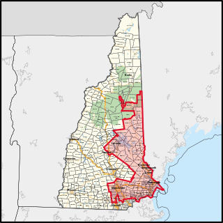
New Hampshire's 1st congressional district covers parts of Southern New Hampshire and the eastern portion of the state. The district contains parts of Hillsborough, Rockingham, Merrimack, Grafton, and Belknap counties; and the entirety of Strafford and Carroll counties.
New Hampshire's 2nd congressional district covers the western, northern, and some southern parts of New Hampshire. It includes the state's second-largest city, Nashua, as well as the state capital, Concord. It is currently represented in the United States House of Representatives by Democrat Ann McLane Kuster.
The New Hampshire State Register of Historic Places (NHSRHP) is a register of historic places administered by the state of New Hampshire and the New Hampshire Division of Historical Resources. Buildings, districts, sites, landscapes (such as cemeteries, parks or town forests), structures, or objects can be added to the register. The register was initiated in 2001 and is authorized by RSA 227 C:33.
The New Hampshire State Library is a library in Concord, New Hampshire, and also a state agency, overseen since 2017 by the New Hampshire Department of Natural and Cultural Resources (DNCR). The physical building is located across the street from the New Hampshire State House.
Rye Harbor State Park is a public recreation area located on the Atlantic Ocean in the town of Rye, New Hampshire. The portion of the state park located on the peninsula known as Ragged Neck offers scenic views of the ocean, the Isles of Shoals, and the town harbor. Activities include saltwater fishing and picnicking. Amenities include benches, picnic tables, pavilion, and restrooms.
The New Hampshire Division of Historical Resources (DHR) is a government agency of the U.S. state of New Hampshire. Benjamin Wilson is director of DHR and the State Historic Preservation Officer, while Sarah Stewart is commissioner of DHR's parent agency, the New Hampshire Department of Natural and Cultural Resources (DNCR). The main office of DHR is located in Concord.
The Lyme–East Thetford Bridge is a historic bridge over the Connecticut River between Lyme, New Hampshire, and East Thetford, Vermont. From the New Hampshire side it carries East Thetford Road, which becomes Vermont Route 113 as it enters Vermont. A Parker truss bridge completed in 1937, it is 471 feet (144 m) long. The bridge was added to the National Register of Historic Places in 2020.
↑ Bruno, Michael A. (2018). Cruising New Hampshire History: A Guide to New Hampshire's Roadside Historical Markers. Lloyds Hill Publishing. ISBN978-0692107287.
This page is based on this Wikipedia article Text is available under the CC BY-SA 4.0 license; additional terms may apply. Images, videos and audio are available under their respective licenses.