Related Research Articles

The Sacramento River is the principal river of Northern California in the United States and is the largest river in California. Rising in the Klamath Mountains, the river flows south for 400 miles (640 km) before reaching the Sacramento–San Joaquin River Delta and San Francisco Bay. The river drains about 26,500 square miles (69,000 km2) in 19 California counties, mostly within the fertile agricultural region bounded by the Coast Ranges and Sierra Nevada known as the Sacramento Valley, but also extending as far as the volcanic plateaus of Northeastern California. Historically, its watershed has reached as far north as south-central Oregon where the now, primarily, endorheic (closed) Goose Lake rarely experiences southerly outflow into the Pit River, the most northerly tributary of the Sacramento.

The Dolores River is a tributary of the Colorado River, approximately 241 miles (388 km) long, in the U.S. states of Colorado and Utah. The river drains a rugged and arid region of the Colorado Plateau west of the San Juan Mountains. Its name derives from the Spanish El Rio de Nuestra Señora de Dolores, River of Our Lady of Sorrows. The river was explored and possibly named by Juan Maria Antonio Rivera during a 1765 expedition from Santa Fe.

The West Branch Delaware River is one of two branches that form the Delaware River. It is approximately 90 mi (144 km) long, and flows through the U.S. states of New York and Pennsylvania. It winds through a mountainous area of New York in the western Catskill Mountains for most of its course, before joining the East Branch along the northeast border of Pennsylvania with New York. Midway or so it is empounded by the Cannonsville Dam to form the Cannonsville Reservoir, both part of the New York City water supply system for delivering drinking water to the City.

The Pit River is a major river draining from northeastern California into the state's Central Valley. The Pit, the Klamath and the Columbia are the only three rivers in the U.S. that cross the Cascade Range.

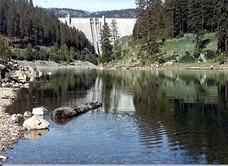
The Feather River is the principal tributary of the Sacramento River, in the Sacramento Valley of Northern California. The river's main stem is about 73 miles (117 km) long. Its length to its most distant headwater tributary is just over 210 miles (340 km). The main stem Feather River begins in Lake Oroville, where its four long tributary forks join—the South Fork, Middle Fork, North Fork, and West Branch Feather Rivers. These and other tributaries drain part of the northern Sierra Nevada, and the extreme southern Cascades, as well as a small portion of the Sacramento Valley. The total drainage basin is about 6,200 square miles (16,000 km2), with approximately 3,604 square miles (9,330 km2) above Lake Oroville.

The Trinity River is a major river in northwestern California in the United States and is the principal tributary of the Klamath River. The Trinity flows for 165 miles (266 km) through the Klamath Mountains and Coast Ranges, with a watershed area of nearly 3,000 square miles (7,800 km2) in Trinity and Humboldt Counties. Designated a National Wild and Scenic River, along most of its course the Trinity flows swiftly through tight canyons and mountain meadows.

The Smith River flows from the Klamath Mountains to the Pacific Ocean in Del Norte County in extreme northwestern California, on the West Coast of the United States. The river, about 25.1 miles (40.4 km) long, all within Del Norte County, flows through the Rogue River – Siskiyou National Forest, Six Rivers National Forest, and Jedediah Smith Redwoods State Park.

The Queets River is a river in the U.S. state of Washington. It is located on the Olympic Peninsula, mostly within the Olympic National Park and empties into the Pacific Ocean.

Schoharie Creek is a river in New York that flows north 93 miles (150 km) from the foot of Indian Head Mountain in the Catskills through the Schoharie Valley to the Mohawk River. It is twice impounded north of Prattsville to create New York City's Schoharie Reservoir and the Blenheim-Gilboa Power Project.

The Palouse River is a tributary of the Snake River in Washington and Idaho, in the northwest United States. It flows for 167 miles (269 km) southwestwards, primarily through the Palouse region of southeastern Washington. It is part of the Columbia River Basin, as the Snake River is a tributary of the Columbia River.

The Similkameen River runs through southern British Columbia, Canada, eventually discharging into the Okanagan River near Oroville, Washington, in the United States. Through the Okanagan River, it drains to the Columbia River. The river is said to be named for an indigenous people called Similkameigh, meaning "treacherous waters".
The Scott River is a 60-mile-long (97 km) river in Siskiyou County, California, United States. It is a tributary of the Klamath River, one of the largest rivers in California.
Loramie Creek is a 40.0-mile-long (64.4 km) tributary of the Great Miami River in western Ohio in the United States. Via the Great Miami and Ohio rivers, it is part of the watershed of the Mississippi River, draining an area of 265 square miles (690 km2). According to the Geographic Names Information System, the stream has also been known historically as "Laramie Creek," "Loramie Ditch," "Loramies Creek," and "Lonamie Creek." It is named after Louis Lorimier, a French-Canadian fur trader who had a trading post in the area in the 18th century.

The Rio Puerco is a tributary of the Rio Grande in the U.S. state of New Mexico. From its source on the west side of the Nacimiento Mountains, it flows about 230 miles (370 km), generally south to join the Rio Grande about 20 miles (32 km) south of Belen and about 50 miles (80 km) south of Albuquerque. Its drainage basin is about 7,350 square miles (19,000 km2) large, of which probably about 1,130 square miles (2,900 km2) are noncontributing.

There are two rivers in Idaho named "Lost", the Big Lost River and the Little Lost River. They are often considered separate streams, but both flow into the same depression and become subterranean, feeding the Snake River Aquifer. The rivers are located in Custer County and Butte County, in Idaho in the United States. Via the aquifer and numerous springs, they are tributaries of the Snake River.

The South Fork Trinity River is the main tributary of the Trinity River, in the northern part of the U.S. state of California. It is part of the Klamath River drainage basin. It flows generally northwest from its source in the Klamath Mountains, 92 miles (148 km) through Humboldt and Trinity Counties, to join the Trinity near Salyer. The main tributaries are Hayfork Creek and the East Fork South Fork Trinity River. The river has no major dams or diversions, and is designated Wild and Scenic for its entire length.
The North Fork Clearwater River is a major tributary of the Clearwater River in the U.S. state of Idaho. From its headwaters in the Bitterroot Mountains of eastern Idaho, it flows 135 miles (217 km) westward and is dammed by the Dworshak Dam just above its mouth in north-central Idaho. Draining a rugged watershed of 2,462 square miles (6,380 km2), the river has an average flow of over 5,600 cubic feet per second (160 m3/s), accounting for a third of the discharge from the Clearwater basin. The river drains parts of Clearwater, Shoshone, Latah, and Idaho counties. Most of the watershed is managed by the U.S. Forest Service. Some of the fish of the river include westslope cutthroat trout, rainbow trout, mountain whitefish, and the threatened bull trout. It also has smallmouth bass and a kokanee salmon run, both from Dworshak Reservoir. The North Fork drainage is home to grizzly bears, cougars, deer, moose, black bear, elk, grey wolves, and osprey. The river used to have a large steelhead run before the implementation of Dworshak Dam. The North Fork of the Clearwater is located within the Clearwater National Forest

The Middle Fork Eel River is a major tributary of the Eel River of northwestern California in the United States. It drains a rugged and sparsely populated region of the Yolla Bolly Mountains, part of the California Coast Range, in Trinity and Mendocino Counties. Its watershed comprises roughly 745 square miles (1,930 km2) of land, or 20% of the entire Eel River basin. The river provides groundwater recharge and is used for recreation and for industrial, agricultural and municipal water supply by residents.
Hayfork Creek is a tributary of the South Fork Trinity River in Northern California in the United States. At over 50 miles (80 km) long, it is the river's longest tributary and is one of the southernmost streams in the Klamath Basin. It winds through a generally steep and narrow course north, then west through the forested Klamath Mountains, but also passes through the Hayfork and Hyampom Valleys, which are the primary agricultural regions of Trinity County.

Thomes Creek is a major watercourse on the west side of the Sacramento Valley in Northern California. The creek originates in the Coast Ranges and flows east for about 62 miles (100 km) to join the Sacramento River, at a point about 7 miles (11 km) northeast of Corning in Tehama County.
References
- 1 2 3 4 5 6 7 8 9 10 11 12 13 14 15 16 17 18 19 U.S. Geological Survey (1992). "Largest Rivers in the United States" (PDF).
- 1 2 3 4 5 6 7 8 9 10 11 12 13 14 15 16 17 18 19 20 21 22 23 24 25 26 27 28 29 30 Benke, Arthur C., ed., and Cushing, Colbert E., ed. Rivers of North America. Burlington, Mass.: Elsevier Academic Press.
{{cite book}}:|author=has generic name (help)CS1 maint: multiple names: authors list (link) - ↑ Leeden, Frits van der (1990). The Water Encyclopedia (2nd ed.). Chelsea, Mich.: Lewis Publishers. p. 126. ISBN 0-87371-120-3.
- ↑ "Snake River below Ice Harbor Dam, WA" (PDF). National Water Information System . United States Geological Survey. 1963–2000. Retrieved 20 April 2011.
- ↑ U.S. Geological Survey (1949). "Large Rivers of the United States, Circular 44" (PDF).
- 1 2 3 "Saint John River". The Canadian Encyclopedia. Archived from the original on 27 December 2018. Retrieved 27 December 2018.
- ↑ "USGS Water Data for Indiana".
- 1 2 "USGS Water Data for Alabama".
- 1 2 3 ""U.S. Geological Survey National Water Summary 1985: State Summaries of Surface-Water Resources". 1987.
- 1 2 3 4 "USGS Water Data for Alaska".
- ↑ "USGS Water Data for Arkansas".
- ↑ "USGS Gage #12396500 on the Pend Oreille River below Box Canyon, near Ione, WA" (PDF). National Water Information System. U.S. Geological Survey. 1952–2013. Retrieved 2014-10-13.
- ↑ "U.S. Geological Survey National Water Summary 1985: State Summaries of Surface-Water Resources". 1987.
- ↑ "USGS Gage #05586100 on the Illinois River at Valley City, IL" (PDF). National Water Information System. U.S. Geological Survey. 1939–2012. Retrieved 2013-11-09.
- ↑ "USGS Gage #11447650 on the Sacramento River at Freeport, CA (Water-Data Report 2009)" (PDF). Water Resources of the United States. U.S. Geological Survey.
- ↑ "Montana Water Resources Data 2004"., file "Mill Creek above Bassoo Creek, near Niarada to Clark Fork at Whitehorse Rapids, near Cabinet, ID" (PDF)..
- ↑ "Estimates of monthly and annual net discharge, in cubic feet per second, of Hudson River at New York, N.Y." United States Geological Survey. October 15, 2010. Archived from the original on March 4, 2016. Retrieved December 30, 2014.
- ↑ http://wdr.water.usgs.gov/wy2009/pdfs/03049500.2009.pdf [ bare URL PDF ]
- ↑ "The Apalachicola-Chattahoochee-Flint (ACF) River National Water Quality Assessment (NAWQA) Program study".
- ↑ "Water-Data Report 2013: 11530500 Klamath River near Klamath, CA" (PDF). U.S. Geological Survey.
- ↑ "Water resources data for the United States, Water Year 2009; gage 02411000, Coosa River at Jordan Dam near Wetumpka, AL" (PDF). USGS.
- ↑ United States Geological Survey; USGS 03193000 KANAWHA RIVER AT KANAWHA FALLS, WV.
- ↑ "USGS Gage #13343000 on the Clearwater River near Lewiston". United States Geological Survey National Water Information System.