List of World Heritage Sites in Angola

Last updated

Flag of Angola.svg
Welterbe.svg UNESCO logo.svg

The United Nations Educational, Scientific and Cultural Organization (UNESCO) World Heritage Sites are places of importance to cultural or natural heritage as described in the UNESCO World Heritage Convention, established in 1972. [1] Angola accepted the convention, making its historical sites eligible for inclusion on the list. As of 2023, Angola has only one World Heritage Site. [2]

Contents

Location of sites

List of sites

NameImageLocationCriteriaYearDescription
Mbanza Kongo, Vestiges of the Capital of the former Kingdom of Kongo The Bansa, or residence of the King of Kongo, called St. Salvador (M'Banza Kongo), Astley 1745.jpg Zaire Province

6°16′04″S14°14′53″E / 6.267778°S 14.248056°E / -6.267778; 14.248056 (Mbanza Kongo, Vestiges of the Capital of the former Kingdom of Kongo)

Cultural (iii) (iv)2017The town of Mbanza Kongo, located on a plateau at an altitude of 570 m, was the political and spiritual capital of the Kingdom of Kongo, one of the largest constituted states in Southern Africa from the 14th to 19th centuries. The historical area grew around the royal residence, the customary court and the holy tree, as well as the royal funeral places. When the Portuguese arrived in the 15th century they added stone buildings constructed in accordance with European methods to the existing urban conurbation built in local materials. Mbanza Kongo illustrates, more than anywhere in sub-Saharan Africa, the profound changes caused by the introduction of Christianity and the arrival of the Portuguese into Central Africa. [3]

Tentative List

SiteImageLocation Criteria Area
ha (acre)
Year of submissionDescription
Fortress of São Miguel Luanda-SMiguelFort2.jpg Luanda Province 8°48′30″S13°13′24″E / 8.8083°S 13.2234°E / -8.8083; 13.2234 (Fortress of São Miguel) Cultural1996 [4]
Fortress of São Pedro da Barra Luanda Province 8°46′24″S13°17′10″E / 8.773333°S 13.286111°E / -8.773333; 13.286111 (Fortress of São Pedro da Barra) Cultural1996 [5]
Fortress of São Francisco do Penedo Luanda Province 8°48′05″S13°15′01″E / 8.8014°S 13.25028°E / -8.8014; 13.25028 (Fortress of São Francisco do Penedo) Cultural1996 [6]
Fortress of Massanganu Fortaleza de Massangano, Angola - 2021-04-17.jpg Cuanza Norte Province 9°37′46″S14°15′23″E / 9.629444°S 14.256389°E / -9.629444; 14.256389 (Fortress of Massanganu) Cultural1996 [7]
Church of Nossa Senhora da Victoria Cuanza Norte Province 9°37′39″S14°15′19″E / 9.627428°S 14.255161°E / -9.627428; 14.255161 (Church of Nossa Senhora da Victoria) Cultural1996 [8]
Fortress of Kambambe Cuanza Norte Province 9°44′32″S14°29′15″E / 9.742322°S 14.487539°E / -9.742322; 14.487539 (Fortress of Kambambe) Cultural1996 [9]
Fortress of Muxima Muxima Fort 01.jpg Bengo Province 9°31′18″S13°57′36″E / 9.52165°S 13.959958°E / -9.52165; 13.959958 (Fortress of Muxima) Cultural1996 [10]
Church of Nossa Senhora da Conceição da Muxima Church of Muxima, pilgrimage site, Bengo province.JPG Bengo Province 10°51′00″N85°37′00″W / 10.85°N 85.6167°W / 10.85; -85.6167 (Church of Nossa Senhora da Conceição da Muxima) Cultural1996 [11]
Little Fort of Kikombo Cuanza Sul Province 11°19′11″S13°49′13″E / 11.319806°S 13.820194°E / -11.319806; 13.820194 (Little Fort of Kikombo) Cultural1996 [12]
Church of Nossa Senhora do Rosario Cuanza Norte Province 9°44′31″S14°29′13″E / 9.742°S 14.487°E / -9.742; 14.487 (Church of Nossa Senhora do Rosario) Cultural1996 [13]
Kwanza Corridor-Cultural Landscape Cuanza river near Dondo, Angola.jpg Bengo Province, Cuanza Norte Province, Malanje Province 9°21′S13°09′E / 9.35°S 13.15°E / -9.35; 13.15 (Kwanza Corridor-Cultural Landscape) Cultural (iii) (v) (vi) (vii)2017 [14]
Archaeological site of Tchitundu-Hulu Sun of Angola.png Namibe Province 15°56′20″S12°52′38″E / 15.93902°S 12.87729°E / -15.93902; 12.87729 (Archaeological site of Tchitundu-Hulu) Cultural (iii) (v)2017 [15]
Cuito Canavale, site of liberation and independence FAPLA tank over.jpg Cuando Cubango Province 15°56′20″S12°52′38″E / 15.93902°S 12.87729°E / -15.93902; 12.87729 (Cuito Canavale, site of liberation and independence) Cultural (iii) (vi)2017 [16]

Related Research Articles

<span class="mw-page-title-main">Ouro Preto</span> Municipality in Minas Gerais, Brazil

Ouro Preto, formerly Vila Rica, is a Brazilian municipality located in the state of Minas Gerais. The city, a former colonial mining town located in the Serra do Espinhaço mountains, was designated a World Heritage Site by UNESCO due to its Baroque colonial architecture. Ouro Preto used to be the capital of Minas Gerais from 1720 until the foundation of Belo Horizonte in 1897.

Nossa Senhora da Conceição may refer to:

<span class="mw-page-title-main">Cidade Velha</span> Settlement in Santiago, Cape Verde

Cidade Velha is a city in the southern part of the island of Santiago, Cape Verde. Founded in 1462, it is the oldest settlement in Cape Verde and its former capital. Once called Ribeira Grande, its name was changed to Cidade Velha in the late 18th century. It is the seat of the Ribeira Grande de Santiago municipality.

<span class="mw-page-title-main">Elvas</span> Municipality in Alentejo, Portugal

Elvas is a Portuguese municipality, former episcopal city and frontier fortress of easternmost central Portugal, located in the district of Portalegre in Alentejo. It is situated about 200 kilometres (120 mi) east of Lisbon, and about 8 kilometres (5.0 mi) west of the Spanish fortress of Badajoz, by the Madrid-Badajoz-Lisbon railway. The municipality population as of 2011 was 23,078, in an area of 631.29 square kilometres (243.74 sq mi). The city itself had a population of 16,640 as of 2011.

<span class="mw-page-title-main">São Cristóvão</span> Municipality in Northeast Region, Brazil

São Cristóvão is a Brazilian municipality in the Northeastern state of Sergipe. Founded at the mouth of the Vaza-Barris River on January 1, 1590, the municipality is the fourth oldest settlement in Brazil. São Cristóvão is noted for its historic city square, São Francisco Square, and numerous early colonial-period buildings. The 3 hectares site was designated a UNESCO World Heritage Site in 2010.

<span class="mw-page-title-main">Lagoa, Portugal</span> Municipality in Algarve, Portugal

Lagoa is a city and municipality in the district of Faro, in the Portuguese region of Algarve. The population of the municipality in 2011 was 22,975, in an area of 88.25 km². Its urban population, in the city of Lagoa proper, is 6,100 inhabitants. An important travel destination, its coast has won numerous accolades. Marinha Beach was considered by the Michelin Guide as one of the 10 most beautiful beaches in Europe and as one of the 100 most beautiful beaches in the world.

<span class="mw-page-title-main">Praia da Luz</span> Civil parish in Algarve, Portugal

Praia da Luz, officially Luz, is a civil parish of the municipality of Lagos, in Algarve region, Portugal. The population of the civil parish in 2011 was 3,545, in an area of 21.78 km2. Also known as Santorini de Portugal, Luz de Lagos or Vila da Luz, "Praia da Luz" is used to refer to both the urbanized village and the beach. The parish had its origins in a small fishing village, but was transformed by several holiday-villa complexes into a tourist area.

<span class="mw-page-title-main">Roman Catholic Archdiocese of Luanda</span> Roman Catholic archdiocese in Angola

The Archdiocese of Luanda is the oldest Roman Catholic archdiocese in Angola.

<span class="mw-page-title-main">Historic Center of Salvador</span> UNESCO World Heritage Site in Bahia, Brazil

The Historic Center (US) or Centre of Salvador de Bahia in Brazil, also known as the Pelourinho or Pelo, is a historic neighborhood in western Salvador, Bahia. It was the city's center during the Portuguese colonial period and was named for the whipping post in its central plaza where enslaved people from Africa were publicly beaten as punishment for alleged infractions. The Historic Center is extremely rich in historical monuments dating from the 17th through the 19th centuries.

The Fortress of Muxima, built of stone and mortar in 1599, is situated in the Bengo Province of Angola next to the Cuanza River.

<span class="mw-page-title-main">Church of Nossa Senhora da Conceição da Muxima</span> Church located in Bengo Province, Angola

The Church of Our lady of Muxima is located in the Muxima District of Bengo Province, western Angola.

The Church of Nossa Senhora do Rosario is located in Kuanza Norte province, Angola.

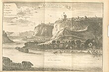
Muxima is a town and commune in the municipality of Quiçama, Luanda Province, Angola. The village, located by Kwanza river, was occupied in 1589 by the Portuguese who erected a church and a fortress in 1599. Muxima means "heart" in Kimbundu. It is the site of a Marian shrine. The town is the home of the 16th century Portuguese Fortress of Muxima.

<span class="mw-page-title-main">Évora</span> Municipality in Alentejo, Portugal

Évora is a city and a municipality in Portugal. It has 53,591 inhabitants (2021), in an area of 1,307.08 square kilometers (504.67 sq mi). It is the historic capital of the Alentejo and serves as the seat of the Évora District.

<span class="mw-page-title-main">São Francisco do Conde</span> Municipality in Northeast, Brazil

São Francisco do Conde is a municipality in the state of Bahia in the North-East region of Brazil. São Francisco do Conde covers 262.856 km2 (101.489 sq mi), and has a population of 40,245 with a population density of 150 inhabitants per square kilometer. It is located 67 kilometres (42 mi) from the state capital of Salvador. According to the Brazilian Institute of Geography and Statistics São Francisco do Conde has the highest concentration of Brazilians of African descent (90%) in Bahia.

<span class="mw-page-title-main">Ilha de Luanda</span>

Ilha do Cabo typically known as Ilha de Luanda is a spit off the shore of Luanda, the capital of Angola, a country on the continents' southwestern coast. It consists of a low sandy strip formed by sedimentation. In administrative terms, the peninsula belongs to the municipality of Ingombota in the Luanda Province.

<span class="mw-page-title-main">M'banza-Kongo</span> Capital of Zaire Province, northwest Angola

M'banza-Kongo, is the capital of Angola's northwestern Zaire Province with a population of 148,000 in 2014. M'banza Kongo was the capital of the Kingdom of Kongo since its foundation before the arrival of the Portuguese in 1483 until the abolition of the kingdom in 1915, aside from a brief period of abandonment during civil wars in the 17th century. In 2017, M'banza Kongo was declared a UNESCO World Heritage Site.

The Fort São Pedro da Barra de Luanda, is located in the former Hill of Cassandama, now Angola Quiluanje neighborhood, in Luanda, Angola.

References

  1. "The World Heritage Convention". UNESCO. Retrieved December 11, 2023.
  2. "Angola". UNESCO. Retrieved November 20, 2023.
  3. "Mbanza Kongo, Vestiges of the Capital of the former Kingdom of Kongo". UNESCO World Heritage Centre. Retrieved 2023-11-20. CC-BY icon.svg Text was copied from this source, which is available under a Creative Commons Attribution 3.0 IGO (CC BY 3.0 IGO) license.
  4. "Fortress of São Miguel". UNESCO World Heritage Centre. Retrieved 2023-11-20.
  5. "Fortress of São Pedro da Barra". UNESCO World Heritage Centre. Retrieved 2023-11-20.
  6. "Fortress of São Francisco do Penedo". UNESCO World Heritage Centre. Retrieved 2023-11-20.
  7. "Fortress of Massanganu". UNESCO World Heritage Centre. Retrieved 2023-11-20.
  8. "Church of Nossa Senhora da Victoria". UNESCO World Heritage Centre. Retrieved 2023-11-20.
  9. "Fortress of Kambambe". UNESCO World Heritage Centre. Retrieved 2023-11-20.
  10. "Fortress of Muxima". UNESCO World Heritage Centre. Retrieved 2023-11-20.
  11. "Church of Nossa Senhora da Conceição da Muxima". UNESCO World Heritage Centre. Retrieved 2023-11-20.
  12. "Little Fort of Kikombo". UNESCO World Heritage Centre. Retrieved 2023-11-20.
  13. "Church of Nossa Senhora do Rosario". UNESCO World Heritage Centre. Retrieved 2023-11-20.
  14. "Kwanza Corridor-Cultural Landscape". UNESCO World Heritage Centre. Retrieved 2023-11-20.
  15. "Archaeological site of Tchitundu-Hulu". UNESCO World Heritage Centre. Retrieved 2023-11-20.
  16. "Cuito Canavale, site of liberation and independence". UNESCO World Heritage Centre. Retrieved 2023-11-20.