Praia is the capital and largest city of Cape Verde. Located on the southern coast of Santiago island, within the Sotavento Islands group, the city is the seat of the Praia Municipality. Praia is the economic, political, and cultural center of Cape Verde.

Mindelo is a port city in the northern part of the island of São Vicente in Cape Verde. Mindelo is also the seat of the parish of Nossa Senhora da Luz, and the municipality of São Vicente. The city is home to 93% of the entire island's population. Mindelo is known for its colourful and animated carnival celebrations, with roots in Portuguese traditions later influenced by the Brazilian culture.

Cidade Velha is a city in the southern part of the island of Santiago, Cape Verde. Founded in 1462, it is the oldest settlement in Cape Verde and its former capital. Once called Ribeira Grande, its name was changed to Cidade Velha in the late 18th century. It is the seat of the Ribeira Grande de Santiago municipality.
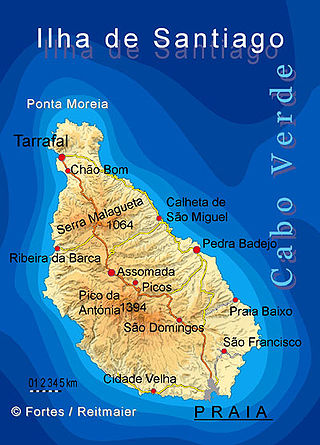
Santiago is the largest island of Cape Verde, its most important agricultural centre and home to half the nation's population. Part of the Sotavento Islands, it lies between the islands of Maio and Fogo. It was the first of the islands to be settled: the town of Ribeira Grande was founded in 1462. Santiago is home to the nation's capital city of Praia.

São Filipe is a city on the west coast of the island of Fogo, Cape Verde. It is the capital of the island, and the seat of the São Filipe Municipality. The island's airport, São Filipe Airport, is located on the southeastern edge of the town and the island's port is 4 km north of the center at Vale de Cavaleiros. The town's elevation is 20 meters.

Mosteiros is a concelho (municipality) of Cape Verde. Situated in the northeastern part of the island of Fogo, it covers 19% of the island area, and is home to 26% of its population. Its seat is the city Mosteiros (Igreja). Its population was 9,524 at the 2010 census, and its area is 89.45 km2.

Ribeira Grande de Santiago is a concelho (municipality) of Cape Verde. It is situated in the southwestern part of the island of Santiago. Its seat is the city Cidade Velha. Its population was 8,325 at the 2010 census, and its area is 137.3 km2.

Cape Verde was a colony of the Portuguese Empire from the initial settlement of the Cape Verde Islands in 1462 until the independence of Cape Verde in 1975.

Forte Real de São Filipe is a 16th century fortress in the city of Cidade Velha in the south of the island of Santiago, Cape Verde. It is located on a plateau above the town centre, 120 meters above sea level. The historic centre of Cidade Velha is an UNESCO World Heritage Site since June 2009. The fort was part of a system of defence for the city, which also included six smaller forts on the coast and a wall along the port.
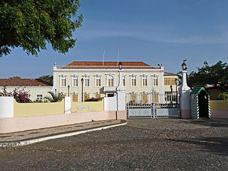
Plateau is the historic centre of the capital city of Praia in the island of Santiago, Cape Verde. It gets its name because it is situated on a plateau overlooking the port of Praia. Its average elevation is 37 meters above sea level. The population of Plateau was 1,019 at the 2010 census. Many public buildings are situated in Plateau, notably the Presidential Palace, the cathedral, the city hall and the Ethnographic Museum.
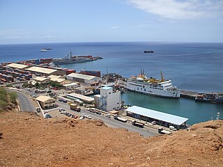
Praia Harbor is the port of the city of Praia in the southern part of the island of Santiago, Cape Verde. It is situated in a natural bay of the Atlantic Ocean. Since the latest modernization in 2014, it has 2 long quays, 3 shorter quays, a quay for fishing boats with fish processing installations, 2 container parks, 2 roll-on/roll-off ramps and a passenger terminal. The total length of the quays is 863 m, and the maximum depth is 13.5 m. The port of Praia played an important role in the colonization of Africa and South America by the Portuguese. With 817,845 metric tonnes of cargo and 85,518 passengers handled (2017), it is the second busiest port of Cape Verde, after Porto Grande (Mindelo).

The following is a timeline of the city of Praia, capital of Cape Verde.
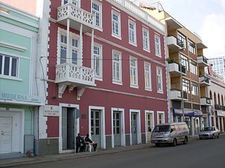
The Architecture of Cape Verde has different architectural styles in the nation. Unlike the African mainland, Cape Verde was uninhabited until 1461 when the Portuguese arrived, most of the other islands were first inhabited after the end of the 15th century. Its architecture was introduced in the 1460s and has its first origins from Portuguese settlers from the Madeira Islands, after the first arrival of mainland Africans, a bit of African architecture would be elements mainly in rural areas. The Manueline was its first architectural style on the island, it was later followed by Renaissance, Baroque, Pombaline, Early Modern and Modern. It was one of the last in the whole of Africa to introduce architecture late. Cape Verde has one of the richest architecture in the western portion of West Africa, the sub-Saharan portion, the richest probably being Mali.

Nossa Senhora do Rosario church is a 15th century church in the town of Cidade Velha on the island of Santiago, Cape Verde. It is located in the northwest of the town, near the right (west) bank of the stream Ribeira Grande de Santiago. The historic centre of Cidade Velha is an UNESCO World Heritage Site since June 2009.

The Pelourinho is an important monument in the city of Cidade Velha in the south of Santiago, Cape Verde. The historic centre of Cidade Velha is an UNESCO World Heritage Site since June 2009. It is a white marble column in Manueline style, standing at the main square of the town. It was a symbol of municipal power, and of slavery: rebellious slaves were punished publicly at the pelourinho.

São Martinho Grande is a settlement in the southern part of the island of Santiago, Cape Verde, and part of the municipality Ribeira Grande de Santiago. It is 4 km east from Cidade Velha and 6.5 km west of Praia city centre. National road EN1-ST05 passes north of it. 1.5 km to its south is Calheta de São Martinho, a small bay of the Atlantic Ocean. It was mentioned as "Kalyete de S. Martin" on the 1747 map by Jacques-Nicolas Bellin.