List of airports in Sri Lanka

Last updated

Map of Sri Lanka Un-sri-lanka.png
Map of Sri Lanka
Colombo's Bandaranaike International Airport is the busiest airport in the country and one of the busiest airports in South Asia. It was estimated to handle over 10.5 million passengers in 2018. 22 boeing 772 app cmb.jpg
Colombo's Bandaranaike International Airport is the busiest airport in the country and one of the busiest airports in South Asia. It was estimated to handle over 10.5 million passengers in 2018.

This is a list of airports in Sri Lanka .

Airport

Airport names shown in bold indicate the facility has scheduled passenger service on a commercial airline.

Contents

International airports

Location served Province ICAO IATA Airport nameUsageRunway(s) Coordinates Total passengers
Katunayake Western VCBICMB Bandaranaike International Airport Public/military3,350 m (10,990 ft) 07°10′52″N79°53′06″E / 7.18111°N 79.88500°E / 7.18111; 79.88500 2,372,928 (2020)
Colombo Western VCCCRML Colombo International Airport, Ratmalana Public/military1,833 m (6,014 ft) 06°49′23″N79°53′12″E / 6.82306°N 79.88667°E / 6.82306; 79.88667 Unknown
Hambantota Southern VCRIHRI Mattala Rajapaksa International Airport Public3,500 m (11,500 ft) 06°17′10″N81°07′32″E / 6.28611°N 81.12556°E / 6.28611; 81.12556 1,536 (2019)
Jaffna Northern VCCJJAF Jaffna International Airport Public/military2,305 m (7,562 ft) 09°47′32″N80°04′12″E / 9.79222°N 80.07000°E / 9.79222; 80.07000 Unknown
Batticaloa Eastern VCCBBTC Batticaloa International Airport Military/public1,095 m (3,593 ft) 07°42′21″N81°37′32″E / 7.70583°N 81.62556°E / 7.70583; 81.62556

Domestic airports

Location served Province ICAO IATA Airport nameUsageRunway(s) Coordinates
Ampara Eastern VCCGADP Ampara Airport (Gal Oya)Military/public1,097 m (3,599 ft) 07°20′15″N81°37′32″E / 7.33750°N 81.62556°E / 7.33750; 81.62556
Anuradhapura North Central VCCAACJ Anuradhapura Airport Military/public1,493 m (4,898 ft) 08°18′05″N80°25′41″E / 8.30139°N 80.42806°E / 8.30139; 80.42806
Dambulla Central VCCSGIU Sigiriya Airport Military/public1,768 m (5,801 ft) 07°57′21″N81°40′44″E / 7.95583°N 81.67889°E / 7.95583; 81.67889
Galle Southern VCCKKCT Koggala Airport Military/public958 m (3,143 ft) 05°59′38″N80°19′16″E / 5.99389°N 80.32111°E / 5.99389; 80.32111
Hambantota Southern VCCWWRZ Weerawila Airport Military/public1,225 m (4,019 ft) 06°15′17″N81°14′07″E / 6.25472°N 81.23528°E / 6.25472; 81.23528
Kalutara Western VCCNKTY Katukurunda Airport Military/public975 m (3,199 ft) 06°33′06″N79°58′45″E / 6.55167°N 79.97917°E / 6.55167; 79.97917
Kandy Central Kandy Airport (Under construction)Military/public2,000 m (6,600 ft)
Kilinochchi Northern Iranamadu Airport Military/public1,500 m (4,900 ft) 09°18′19″N80°29′15″E / 9.30528°N 80.48750°E / 9.30528; 80.48750
Minneriya North Central VCCHHIM Hingurakgoda Airport Military/public2,200 m (7,200 ft)
Puttalam North Western LK-0002 Palaviya Airport Military/public333 m (1,093 ft) 07°58′48″N79°51′24″E / 7.98000°N 79.85667°E / 7.98000; 79.85667
Trincomalee Eastern VCCTTRR China Bay Airport Military/public2,397 m (7,864 ft) 08°32′22″N81°10′54″E / 8.53944°N 81.18167°E / 8.53944; 81.18167
Vavuniya Northern VCCV Vavuniya Airport Military/public1,524 m (5,000 ft) 08°44′28″N80°29′52″E / 8.74111°N 80.49778°E / 8.74111; 80.49778

Waterdromes

Location served Province ICAO IATA Airport nameUsageRunway(s) Coordinates
Ampara Eastern AFK Kondavattavan Tank Waterdrome
Arugam Bay Eastern AYY Arugam Bay Lagoon Waterdrome
Batticaloa Eastern Lady Manning Drive Waterdrome
Bentota Southern BJT Bentota River Airport
Castlereigh Central NUF Castlereigh Reservoir Waterdrome
Colombo-Dandugama Western DGM Dandugama Water Aerodrome
Colombo-Peliyagoda Western KEZ Kelani River-Peliyagoda Waterdrome
Dambulla Central DBU Ibbankatuwa Tank Waterdrome (Dambulu Oya Tank)
Dikwella Southern DIW Mawella Lagoon Airport
Hambantota Southern HBT Bandagiriya Tank Waterdrome
Iranamadu Northern IRU Iranamadu Waterdrome
Jaffna Northern Jaffna Waterdrome
Kalpitiya North Western Kalpitiya Waterdrome
Kandy-Polgolla Central KDZ Polgolla Reservoir Waterdrome
Kandy-Victoria Central KDW Victoria Dam Waterdrome
Koggala Southern KCT Koggala Airport
Nuwara Eliya Central NUA Lake Gregory Waterdrome
Pasikudah Eastern PQD Passikudah Waterdrome
Tissamaharama Southern TTW Tissa Tank Waterdrome
Trincomalee Eastern THW Trincomalee Harbour Waterdrome

See also

Hambantota's Mattala Rajapaksa International Airport is the second largest airport. UL A330 at mria.jpg
Hambantota's Mattala Rajapaksa International Airport is the second largest airport.

Related Research Articles

<span class="mw-page-title-main">Entebbe International Airport</span> International airport in Uganda

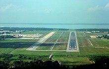
Entebbe International Airport is the only international airport in Uganda. It is located about 6 kilometres (3.7 mi) southwest of the town of Entebbe, on the northern shores of Lake Victoria. This is approximately 40 kilometres (25 mi) by road south-west of the central business district of Kampala, the capital city of Uganda.

Anuradhapura Airport is a domestic airport serving Anuradhapura in Sri Lanka. It is also a military airbase known as Sri Lanka Air Force Base Anuradhapura or SLAF Base Anuradhapura.

<span class="mw-page-title-main">Ampara Airport</span> Airport in Gal-Oya, Sri Lanka

Ampara Airport, also known Gal-Oya Airport, is a domestic airport in Gal-Oya in southeastern Sri Lanka. It is also a military airbase known as Sri Lanka Air Force Ampara or SLAF Ampara.

Katukurunda Airport is a domestic airport located near the town of Kalutara in Sri Lanka. It is also a military airbase known as Sri Lanka Air Force Katukurunda or SLAF Katukurunda.

Hingurakgoda Airport, also known as Minneriya Airport, is a domestic airport in Hingurakgoda, Sri Lanka. It is also a military airbase known as Sri Lanka Air Force Base Hingurakgoda.

References

Map all coordinates using: OpenStreetMap