Transport in Afghanistan is done mostly by road, rail and air. Much of the nation's road network was built in the mid-20th century but left to ruin during the last two decades of that century due to war and political turmoil. Officials of the current Islamic Emirate have continued to improve the national highways, roads, and bridges. In 2008, there were about 700,000 vehicles registered in Kabul. At least 1,314 traffic collisions were reported in 2022.
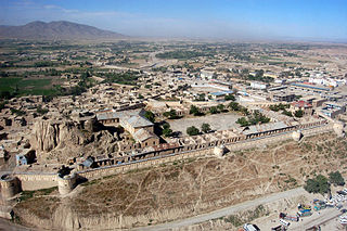
Gardez is the capital of the Paktia Province of Afghanistan. The population of the city was estimated to be ca. 10,000 in the 1979 census and was estimated to be 70,000 in 2008. The majority of the city's native population is Pashtun. The city of Gardez is located at the junction between two important roads that cut, through a huge alpine valley. Surrounded by the mountains and deserts of the Hindu Kush, which boil up from the valley floor to the north, east and west, it is the axis of commerce for a huge area of eastern Afghanistan and has been a strategic location for armies throughout the country's long history of conflict. Observation posts built by Alexander the Great are still crumbling on the hilltops just outside the city limits. The city of Gardez has a population of 70,641. It has 13 districts and a total land area of 6,174 hectares (23.84 sq mi). The total number of dwellings in this city is 7,849.

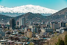
Herat is one of the thirty-four provinces of Afghanistan, located in the western part of the country. Together with Badghis, Farah, and Ghor provinces, it makes up the north-western region of Afghanistan. Its primary city and administrative capital is Herat City. The province of Herat is divided into about 17 districts and contains over 2,000 villages. It has a population of about 3,780,000, making it the second most populated province in Afghanistan behind Kabul Province. The population is multi-ethnic but largely Persian-speaking. Herat dates back to the Avestan times and was traditionally known for its wine. The city has a number of historic sites, including the Herat Citadel and the Musalla Complex. During the Middle Ages Herat became one of the important cities of Khorasan, as it was known as the Pearl of Khorasan.

Ghazni, historically known as Ghaznain (غزنين) or Ghazna (غزنه), also transliterated as Ghuznee, and anciently known as Alexandria in Opiana, is a city in southeastern Afghanistan with a population of around 190,000 people. The city is strategically located along Highway 1, which has served as the main road between Kabul and Kandahar for thousands of years. Situated on a plateau at 2,219 metres (7,280 ft) above sea level, the city is 150 kilometres (93 mi) south of Kabul and is the capital of Ghazni Province. The name Ghazni drives from the Persian word "ganj", meaning ‘treasure’.
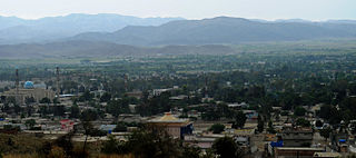
Khōst is the capital of Khost Province in Afghanistan. It is the largest city in the southeastern part of the country, and also the largest in the region of Loya Paktia. To the south and east of Khost lie Waziristan and Kurram in Pakistan. Khost is the home of Shaikh Zayed University. The Khost Airport is located in the eastern area of the city.

Ghazni is one of the 34 provinces of Afghanistan, located in southeastern Afghanistan. The province contains 19 districts, encompassing over a thousand villages and roughly 1.3 million people, making it the 5th most populous province. The city of Ghazni serves as the capital. It lies on the important Kabul–Kandahar Highway, and has historically functioned as an important trade center. The Ghazni Airport is located next to the city of Ghazni and provides limited domestic flights to Afghanistan's capital, Kabul.
Ghōr also spelled Ghowr or Ghur is one of the thirty-four provinces of Afghanistan. It is located in the western Hindu Kush in central Afghanistan, towards the northwest. The province contains eleven districts, encompassing hundreds of villages, and approximately 764,472 settled people. Firuzkoh is the capital of the province.

Khost is one of the 34 provinces of Afghanistan located in the southeastern part of the country. Khost consists of thirteen districts and the city of Khost serves as the capital of the province. Historically, Khost used to be a part of Paktia and a larger region surrounding Khost is still referred to as Loya Paktia.

Logar is one of the 34 provinces of Afghanistan located in the eastern section of the country. It is divided into 7 districts and contains hundreds of villages. Puli Alam is the capital of the province. As of 2021, Logar has a population of approximately 442,037 people, most of whom are ethnic Pashtuns and Tajiks.

Maidan Wardak or Wardak, also called Wardag or Wardak is one of the 34 provinces of Afghanistan, located in the central region of Afghanistan. It is divided into eight districts and has a population of approximately 500,000. The capital of the province is Maidan Shar, while the most populous district in the province is Saydabad District. Wardak is known for one of its famous high peak mountain known as.

Paktika is one of the 34 provinces of Afghanistan, located in the eastern part of the country. Forming part of the larger Loya Paktia region, Paktika has a population of about 789,000, mostly ethnic Pashtuns. The town of Sharana serves as the provincial capital, while the most populous city is Urgun.

Lashkargāh, historically called Bost or Boost, is a city in southwestern Afghanistan and the capital of Helmand Province. It is located in Lashkargah District, where the Arghandab River merges into the Helmand River. The city has a population of 201,546 as of 2006. Lashkargah is linked by major roads with Kandahar to the east, Zaranj on the border with Iran to the west, and Farah and Herat to the north-west. It is mostly very arid and desolate. However, farming does exist around the Helmand and Arghandab rivers. Bost Airport is located on the east bank of the Helmand River, five miles north of the junction of the Helmand and Arghandab rivers. Because of the trading hubs, it is Afghanistan's second largest city in size, after Kabul and before Kandahar.

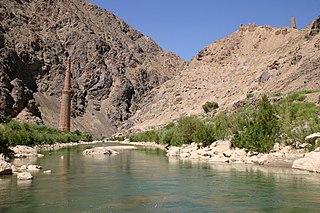
Chaghcharān, also called Firozkoh, is a town and district in central Afghanistan, which serves as the capital of Ghor Province. It is located on the southern side of the Hari River, at an altitude of 2,230 m above sea level. Chaghcharan is linked by a 380 kilometres (240 mi) long highway with Herat to the west, and a 450 kilometres (280 mi) long highway with Kabul to the east. The town has an airport called Chaghcharan Airport.

Dushi district is located in the central part of Baghlan Province, Afghanistan. It lies on the major Kabul-Kunduz highway. The population of the district was estimated to be around 57,160 in 2004. Hazaras are around 60% of the population and make up the majority in the district, followed by Tajiks (39%). The centre of the district is Dushi. Dushi was considered contested between the Afghan Government and the Taliban in late 2018.

Bäk District is situated in the northern part of Khost Province, Afghanistan. It borders Tere Zayi District to the south, Sabari District to the west, Zazi Maydan District to the north, and Khyber Pakhtunkhwa in Pakistan to the east. According to Afghanistan's National Statistics and Information Authority (NSIA), the 2020 estimated population of the district was 24,977 people. The district center is the village of Bäk, located in the southern part close to the border with Tere Zayi District.
Gurbuz District is situated in the southeast part of Khost Province, Afghanistan. It borders Tani District to the west, Mando Zayi and Khost districts to the north and Khyber Pakhtunkhwa in Pakistan to the southeast. Governor of Gurbuz District is Abdulhai Zazi. The Afghan National Security Forces (ANSF) are responsible for all law enforcement activities in the district.
Zazi Maidan District, or Jaji Maidan or Dzadzi Maidan, is located in the northeastern part of Khost Province, Afghanistan. It borders Bak District to the west, Paktia Province to the north, and the Kurram Agency of Pakistan to the north and east. According to Afghanistan's National Statistics and Information Authority (NSIA), the 2020 estimated population of the district was 26,236 people. The district center is the village of Zazi Maidan, situated in the eastern part of the district.

Nadir Shah Kot District is situated in the western part of Khost Province, Afghanistan. It borders Paktia Province and Shamal District to the west, Qalandar District to the north, Musa Khel District to the northeast, Khost (Matun) District to the east, Mandozayi District to the southeast and Tani and Spera districts to the south.
Sabari & Yaqubi District is situated in the northwest part of Khost Province, Afghanistan. It borders Musa Khel District to the west, Paktia Province to the north, Bak District to the east and Tere Zayi and Khost districts to the south. Sabari & Yaqubi District has its own governor, who is appointed by the serving governor of Khost Province, and the Afghan National Security Forces (ANSF) are responsible for all law enforcement activities.
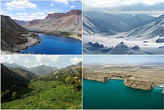
Tourism in Afghanistan is regulated by the Ministry of Information and Culture. There are at least 350 tourism companies operating in Afghanistan. Tourism was at its peak before the 1978 Saur Revolution, which was followed by the decades of war. Between 2013 and 2016, Afghan embassies issued between 15,000 and 20,000 tourist visas annually.