List of coal mines in Japan

Last updated

This list of mines in Japan is subsidiary to the list of mines article and lists working, defunct and future mines in the country and is organised by the primary mineral output.

Contents

Card of mines of Japan

Japan natural location map with side map of the Ryukyu Islands.jpg
Location dot black.svg
Yoshio
Location dot black.svg
Kamimio
Location dot black.svg
Tsunawaki
Location dot black.svg
Akasaka
Location dot black.svg
Mameda
Location dot black.svg
Yoshikuma
Location dot black.svg
Yamano
Location dot black.svg
Tagawa
Location dot black.svg
Kamiyamada
Location dot black.svg
Hōjō
Location dot black.svg
Namazuta
Location dot black.svg
Kurate
Location dot black.svg
Shinnyū
Location dot black.svg
Iizuka
Location dot black.svg
Iwate
Location dot black.svg
Mogami
Location dot black.svg
Amakusa coalfield
Location dot black.svg
Yūbari
Location dot black.svg
Ikushunbetsu
Location dot black.svg
Miike
Location dot black.svg
Hashima
Location dot black.svg
Iriomote
Location dot black.svg
Utara
Location dot black.svg
Kami-Sunagawa
Location dot black.svg
Horonai
The mines of Japan [1]

List of mines

MineTop Annual ProductionCoordinatesAssociated TownOwnerDatesCoalfield
Iwate mine [2] 39°53′06″N141°37′52″E / 39.885°N 141.631°E / 39.885; 141.631 Iwaizumi, Iwate ?
Hokutan Horonai coal mine 1500.000 43°13′16″N141°54′32″E / 43.221°N 141.909°E / 43.221; 141.909 Mikasa Hokutan 1879–1989 Ishikari
Hokutan Ikushunbetsu Coal Mine 200.000 43°15′40″N141°58′05″E / 43.261°N 141.968°E / 43.261; 141.968 Ikushunbetsu Hokutan 1885–1957Ishikari
Sumitomo Ponbetsu coal mine 1500.000 43°15′54″N141°57′36″E / 43.265°N 141.960°E / 43.265; 141.960 Mikasa Sumitomo 1902–1971Ishikari
Sumitomo Yayoi coal mine 43°15′32″N141°56′17″E / 43.259°N 141.938°E / 43.259; 141.938 Mikasa Sumitomo 1905–1970Ishikari
Mitsubishi Bibai coal mine 1600.000 43°20′02″N141°58′08″E / 43.334°N 141.969°E / 43.334; 141.969 Bibai Mitsubishi 1913–1972Ishikari
Mitsui Bibai coal mine 1000.000 43°20′02″N141°55′01″E / 43.334°N 141.917°E / 43.334; 141.917 Bibai Mitsui 1918–1963Ishikari
Hokutan Yūbari coal mine 2000.000 43°03′50″N141°59′06″E / 43.064°N 141.985°E / 43.064; 141.985 Yūbari Hokutan 1890–1977Ishikari
Hokutan Mayachi coal mine 700.000 42°58′16″N142°04′16″E / 42.971°N 142.071°E / 42.971; 142.071 Yūbari Hokutan 1905–1987Ishikari
Mitsubishi Ōyūbari coal mine 1000.000 43°05′49″N142°05′42″E / 43.097°N 142.095°E / 43.097; 142.095 Yūbari Mitsubishi 1906–1973Ishikari
Hokutan Heiwa coal mine 1000.000 43°01′01″N141°59′28″E / 43.017°N 141.991°E / 43.017; 141.991 Yūbari Hokutan 1937–1975Ishikari
Mitsubishi Minami Ōyūbari coal mine 43°01′44″N142°05′24″E / 43.029°N 142.090°E / 43.029; 142.090 Yūbari Mitsubishi 1966–1990Ishikari
Hokutan Yūbari Shin coal mine 42°59′02″N142°01′01″E / 42.984°N 142.017°E / 42.984; 142.017 Yūbari Hokutan 1970–1981Ishikari
Hokutan Manji coal mine 500.000 43°08′02″N141°59′31″E / 43.134°N 141.992°E / 43.134; 141.992 Manji Hokutan 1905–1976Ishikari
Hokutan Miruto coal mine Miruto Hokutan 1917–1969Ishikari
Hokutan Kakuta coal mine Kakuta Hokutan 1927–1953Ishikari
Sumitomo Akabira coal mine 1900.000 43°32′53″N142°03′22″E / 43.548°N 142.056°E / 43.548; 142.056 Akabira Sumitomo 1895–1993Ishikari
Moshiri coal mine Akabira Yūbetsu 1918–1969Ishikari
Toyosato coal mine Akabira Toyosato Mining Company 1937–1954Ishikari
Hokutan Akama coal mine 43°33′11″N142°02′53″E / 43.553°N 142.048°E / 43.553; 142.048 Akabira Hokutan 1938–1973Ishikari
Sorachi coal mine 1500.000 43°30′40″N142°03′07″E / 43.511°N 142.052°E / 43.511; 142.052 Utashinai Hokutan 1890–1995Ishikari
Hokutan Kamui coal mine 500.000 Utashinai Hokutan 1891–1971Ishikari
Sumitomo Kami Utashinai coal mine 300.000 43°31′26″N142°03′07″E / 43.524°N 142.052°E / 43.524; 142.052 Utashinai Sumitomo 1894–1988Ishikari
Sumitomo Utashinai coal mine 800.000 Utashinai Sumitomo 1905–1971Ishikari
Mitsubishi Ashibetsu coal mine 300.000 Ashibetsu Mitsubishi 1914–1964Ishikari
Yuya coal mine 200.000 Utashinai Yuya 19**–1965Ishikari
Meiji mining kami Ashibetsu coal mine 100.000 Ashibetsu Meiji mining 1935–1963Ishikari
Takane coal mine 200.000 Ashibetsu Takane 1938–1967Ishikari
Mitsui Ashibetsu coal mine 1700.000 Ashibetsu Mitsui 1939–1992Ishikari
Mitsui Sunagawa coal mine 1600.000 43°28′01″N142°00′47″E / 43.467°N 142.013°E / 43.467; 142.013 Kamisunagawa Mitsui 1914–1987Ishikari
Mitsui Oku Naie coal mine 460.000 Naie Mitsui 1947–1966Ishikari
Shōwa coal mine Numata Shōwa 1930–1969Rumoi
Asano Uryū coal mine Numata Shōwa 1930–1968Rumoi
Haboro coal mine Happoro Shōwa 1948–1970Rumoi
Yoshio coal mine 33°38′00″N130°42′40″E / 33.633466°N 130.711221°E / 33.633466; 130.711221 X Asō Chikuhō
Kamimio coal mine 33°37′16″N130°42′59″E / 33.620987°N 130.716355°E / 33.620987; 130.716355 X Asō Chikuhō
Tsunawaki coal mine 33°38′09″N130°43′49″E / 33.635951°N 130.730315°E / 33.635951; 130.730315 X Asō Chikuhō
Miike coal mine 33°00′50″N130°27′22″E / 33.014°N 130.456°E / 33.014; 130.456 Ōmuta Mitsui 1872–1997Miike
Mitsi Ikeshima Coal Mine 32°53′06″N129°36′04″E / 32.885°N 129.601°E / 32.885; 129.601 Ikeshima Mitsubishi 2002Nishisonogi
Mitsubishi Takashima Coal Mine 32°40′N129°45′E / 32.66°N 129.75°E / 32.66; 129.75 Takashima Mitsubishi 1984Nishisonogi
Mitsubishi Hashima coal mine 32°37′41″N129°44′17″E / 32.628°N 129.738°E / 32.628; 129.738 Hashima Mitsubishi 1869–1974Nishisonogi
Iriomote Coal Mine 130.000 Iriomote Mitsui 1886–1960Okinawa
Utara Coal Mine 30.000 Iriomote Marusan Mining Company 1936–1943Okinawa

Related Research Articles

<span class="mw-page-title-main">Sorachi Subprefecture</span> Place in Hokkaido

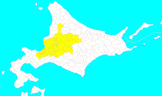
Sorachi Subprefecture is a subprefecture of Hokkaido Prefecture, Japan. As of 2004, its estimated population is 373,736 and its area is 6,558.26 km2.

<span class="mw-page-title-main">Eniwa, Hokkaido</span> City in Hokkaido, Japan

Eniwa is a city in Ishikari Subprefecture, Hokkaido, Japan. It is on the Ishikari plain, 8 km north of Chitose, and 26 km south of the prefectural capital Sapporo. It is reached through route 36 and the Chitose Railway Line. The town is separated into three major areas: Eniwa in the south, Megumino in the center, and Shimamatsu in the north.

<span class="mw-page-title-main">Akabira</span> City in Hokkaido, Japan

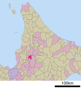
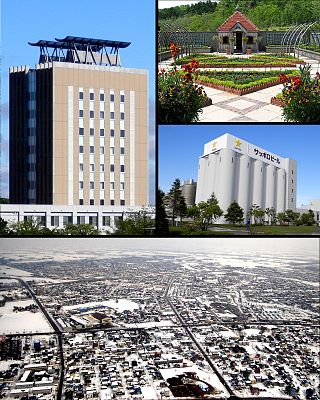
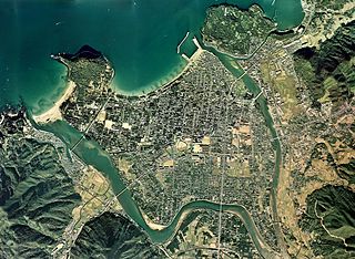
Akabira is a city located in central Sorachi Subprefecture, Hokkaido, Japan. The name is Ainu for "mountain ridge".

<span class="mw-page-title-main">Ichinohe, Iwate</span> Town in Tōhoku, Japan

Ichinohe is a town located in Iwate Prefecture, Japan. As of 1 April 2020, the town had an estimated population of 12,053, and a population density of 40 persons per km² in 5645 households. The total area of the town is 300.03 square kilometres (115.84 sq mi).

<span class="mw-page-title-main">Taihoku Prefecture</span> Administrative division of Taiwan under Japanese rule

Taihoku Prefecture was an administrative division of Taiwan created in 1920, during Japanese rule. The prefecture consisted of modern-day Keelung, New Taipei City, Taipei and Yilan County. Its government office, which is now occupied by the Control Yuan of Taiwan, was in Taihoku City.

<span class="mw-page-title-main">Shintotsukawa, Hokkaido</span> Town in Hokkaido, Japan

Shintotsukawa is a town located in Sorachi Subprefecture, Hokkaido, Japan.

<span class="mw-page-title-main">Sorachi District, Hokkaido</span> District in the country of Japan

Sorachi is a district divided between Sorachi and Kamikawa Subprefectures, Hokkaido, Japan. As of 2004, the district has an estimated population of 53,011 and an area of 1,497.21 km2, giving a population density of 35.41 persons per square kilometer.

<span class="mw-page-title-main">Ishikari Province</span> Former province of Japan

Ishikari Province was a short-lived province located in Hokkaidō. It corresponded to modern-day Ishikari Subprefecture minus Chitose and Eniwa, all of Sorachi Subprefecture and the southern half of Kamikawa Subprefecture excluding Shimukappu

<span class="mw-page-title-main">Hideaki Sorachi</span> Japanese manga artist

Hideaki Sorachi is the pen name of a Japanese manga artist, most well known for his manga Gintama, which began serialization in 2003 and ended in 2019. He has also written numerous one-shots, including Dandelion, for which he won the Tenkaichi Honourable Mention Manga Award in 2002. Sorachi's distinctive sense of humour and writing style has been the subject of academic research papers. As of February 2018, the Gintama manga has sold 55 million units in Japan.

<span class="mw-page-title-main">Akaganeite</span> Iron(III) oxide-hydroxide mineral

Akaganeite, also written as the deprecated Akaganéite, is a chloride-containing iron(III) oxide-hydroxide mineral, formed by the weathering of pyrrhotite (Fe1−xS).

<span class="mw-page-title-main">Kensuke Kazama</span> Japanese photographer

Kensuke Kazama was a Japanese photographer who photographed the one-time mining town of Yūbari, Hokkaidō.

<span class="mw-page-title-main">Bibai Dam</span> Dam in Hokkaidō, Japan.

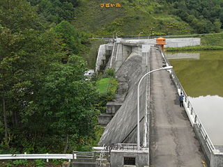
The Bibai Dam is a dam in Bibai, Hokkaidō, Japan. The Bibai Dam is constructed along the Mikawa River and is part of the Ishikari River water system.

Hokkaido Colliery and Railway Company was a company engaged in coal mining, railway operation and shipping in Hokkaidō, Japan.

<span class="mw-page-title-main">Sites of Japan's Meiji Industrial Revolution: Iron and Steel, Shipbuilding and Coal Mining</span> UNESCO World Heritage Site in Japan

Sites of Japan's Meiji Industrial Revolution: Iron and Steel, Shipbuilding and Coal Mining are a group of historic sites that played an important part in the industrialization of Japan in the Bakumatsu and Meiji periods (1850s–1910), and are part of the industrial heritage of Japan. In 2009 the monuments were submitted jointly for inscription on the UNESCO World Heritage List under criteria ii, iii, and iv. The sites were accepted at the 39th UNESCO World Heritage session, under the condition to take measures "that allow an understanding that there were a large number of Koreans and others who were brought against their will and forced to work under harsh conditions ...", and again, such measures have yet to be implemented.

<span class="mw-page-title-main">Hokutan Horonai coal mine</span>

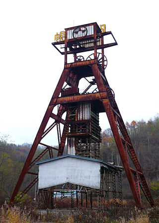
The Horonai coal mine is the oldest mine of the Ishikari coalfield of the Sorachi (Mikasa) mining region on the Japanese island of Hokkaido. Since its privatisation in 1889, the mine came under the management of the Hokutan company until its closure in 1989.

<span class="mw-page-title-main">Ishikari coalfield</span>

The Ishikari coal basin lies in the tertiary mountains of the mining region of Sorachi, east of the Ishikari Plain in central Hokkaido. These coal veins contain the largest quantity of coal of Japan. Because of its late discovery the historical role of the coalfield could not be compared with that of the Chikuho coalfield, but its economic importance since the Japanese industrial revolution is comparable with that of the southern Chikuhō coalfield.

Takikawa Museum of Art and Natural History opened in Takikawa, Hokkaidō, Japan in 1986. The collection includes works by Iwahashi Eien, Ichiki Masumi, and Ueda Sōkyū as well as the fossil type specimen of the Takikawa sea cow, discovered in the bed of the Sorachi River in 1980 and designated a Prefectural Natural Monument.

<span class="mw-page-title-main">Hokkaido Heritage</span>

Hokkaidō Heritage is an initiative aimed at the valorization and transmission to the next generation of the tangible and intangible natural, cultural, historical, and industrial heritage of Hokkaidō, Japan. It is advanced by the Hokkaidō Heritage Council (北海道遺産協議会), an NPO, and endorsed by the prefectural government, amongst other bodies. Sixty-seven assets have been identified to date in three sessions, the first twenty-five on 22 October 2001, a further twenty-seven on 22 October 2004, and more recently, fifteen on 1 November 2018. The scheme does not include a formal system for management or preservation but is intended to be a citizen-led movement with the concomitant benefits of promoting tourism, fostering pride and a sense of belonging in local communities, developing human capital and potential, and the revitalization of local economies.

References

  1. Hokkaidō Shinbun Sorachi 'Yama' Shuzaihan (北海道新聞空知「炭鉱」取材班), Sorachi Tankōisan Sanpō (空知炭鉱遺産散歩), pp.34-199.; Hokkaido Government Sorachi Subprefectural Office (空知支庁), Sorachi Tankōisan to Kankō Archived 2013-07-27 at the Wayback Machine (空知炭鉱遺産と観光).
  2. "Iwate mine, Iwaizumi, Shimohei District, Iwate Prefecture, Japan".