
Interstate 4 (I-4) is an Interstate Highway located entirely within the US state of Florida, maintained by the Florida Department of Transportation (FDOT). Spanning 132.30 miles (212.92 km) along a generally southwest–northeast axis, I-4 is entirely concurrent with State Road 400 (SR 400). In the west, I-4 begins at an interchange with I-275 in Tampa. I-4 intersects with several major expressways as it traverses Central Florida, including US Highway 41 (US 41) in Tampa; US 301 near Riverview; I-75 near Brandon; US 98 in Lakeland; US 27 in unincorporated Davenport; US 192 in Celebration; Florida's Turnpike in Orlando; and US 17 and US 92 in multiple junctions. In the east, I-4 ends at an interchange with I-95 in Daytona Beach, while SR 400 continues for roughly another four miles (6.4 km) and ends at an intersection with US 1 on the city line of Daytona Beach and South Daytona.

Interstate 295 (I-295), an auxiliary route of I-95, is a beltway around central Jacksonville, Florida, United States. The 61.04-mile-long (98.23 km) beltway consists of two segments, the West Beltway and the East Beltway, with I-95 serving as the dividing line between the two. The entire highway carries a hidden designation as SR 9A by the Florida Department of Transportation (FDOT). The West Beltway was constructed in the 1970s, with the East Beltway being built from the 1980s to the 2000s.

State Road 528 (SR 528), alternatively named the Martin Andersen Beachline Expressway, is a partially-tolled state road in the U.S. state of Florida; it is maintained by the Florida's Turnpike Enterprise (FTE), the Central Florida Expressway Authority (CFX), and the Florida Department of Transportation (FDOT). Spanning approximately 53 miles (85 km) along a west–east axis, it connects Interstate 4 (I-4) in Orlando with I-95, Titusville, and Cape Canaveral on the Space Coast. It passes close to the tourist areas of Orlando, including SeaWorld and Universal Orlando, and serves the north entrance to Orlando International Airport. Near its east end, it passes over the Intracoastal Waterway on the Emory L. Bennett Causeway, and ends at SR A1A and SR 401 near Port Canaveral.

Interstate 195 (I-195) is a 4.42-mile-long (7.11 km) auxiliary Interstate Highway connecting I-95, its parent route, in the west with Miami Beach in the east. It crosses Biscayne Bay by traveling over the Julia Tuttle Causeway. The causeway is named after Miami founder Julia Tuttle.

The Jacksonville Transportation Authority (JTA) is the independent agency responsible for public transit in the city of Jacksonville, Florida, and roadway infrastructure that connects northeast Florida. However, they do not maintain any roadways. In 2022, the system had a ridership of 6,646,100, or about 22,100 per weekday as of the third quarter of 2023.

State Road 520 (SR 520) is a 34.5-mile (55.5 km) east–west state highway in central Florida, United States, connecting with SR 50 in the Orlando area with SR A1A in Cocoa Beach.

Interstate 95 (I-95) is the main Interstate Highway of Florida's Atlantic Coast. It begins at a partial interchange with US Highway 1 (US 1) just south of downtown Miami and heads north through Jacksonville, and to the Georgia state line at the St. Marys River near Becker. The route also passes through the cities of Fort Lauderdale, West Palm Beach, Port St. Lucie, Titusville, and Daytona Beach.

State Road 13 (SR 13) is a 28.25-mile-long (45.46 km) state highway in the U.S. state of Florida, running north from SR 16 near Green Cove Springs, through Switzerland to Jacksonville on the east shore of the St. Johns River.

Interstate 75 (I-75) is a part of the Interstate Highway System that runs from the Hialeah–Miami Lakes border, a few miles northwest of Miami, to Sault Ste. Marie in the Upper Peninsula of Michigan. I-75 begins its national northward journey near Miami, running along the western parts of the Miami metropolitan area before traveling westward across Alligator Alley, resuming its northward direction in Naples, running along Florida's Gulf Coast, and passing the cities of Fort Myers, Punta Gorda, Venice, and Sarasota. The freeway passes through the Tampa Bay area before turning inward toward Ocala, Gainesville, and Lake City before leaving the state and entering Georgia. I-75 runs for 471 miles (758 km) in Florida, making it the longest Interstate in the state and also the longest in any state east of the Mississippi River. The Interstate's speed limit is 70 mph (110 km/h) for its entire length in Florida.
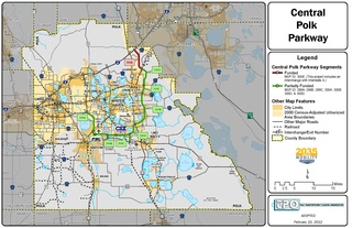
The Central Polk Parkway, also known as State Road 570B (SR 570B), is a proposed toll road in Polk County, Florida. The proposed road is actually two separate roads—called legs by the Florida Department of Transportation (FDOT). The western segment will connect the Polk Parkway with SR 60 between Bartow and Lake Wales. The eastern leg will start a few miles east of SR 60 and run north, parallel to US Highway 27 (US 27), and terminate at Interstate 4 (I-4) north of Davenport. The most recent, and viable, proposed routing will connect the two legs together near the CSX Intermodal Facility south of Wahneta. In December 2015, FDOT announced the cancellation of any further work on the project, citing insufficient funds and low traffic volume. The project continued to have the support of the local business community and local politicians, however, and it was revived in 2018.

The Seaboard–All Florida Railway was a subsidiary of the Seaboard Air Line Railroad that oversaw two major extensions of the system in the early 1920s to southern Florida on each coast during the land boom. One line extended the Seaboard's tracks on the east coast from West Palm Beach down to Fort Lauderdale and Miami, while the other extension on the west coast extended the tracks from Fort Ogden south to Fort Myers and Naples, with branches from Fort Myers to LaBelle and Punta Rassa. These two extensions were heavily championed by Seaboard president S. Davies Warfield, and were constructed by Foley Brothers railroad contractors. Both extensions also allowed the Seaboard to better compete with the Florida East Coast Railway and the Atlantic Coast Line Railroad, who already served the lower east and west coasts of Florida respectively.
