
Manatee County is a county in the Central Florida portion of the U.S. state of Florida. As of the 2020 US Census, the population was 399,710. Manatee County is part of the North Port-Sarasota-Bradenton Metropolitan Statistical Area. Its county seat and largest city is Bradenton. The county was created in 1855 and named for the Florida manatee, Florida's official marine mammal. Features of Manatee County include access to the southern part of the Tampa Bay estuary, the Sunshine Skyway Bridge, and the Manatee River.
Sarasota County is located in southwest Central Florida on the Gulf Coast. At the 2020 US census, the population was 434,006. Its county seat is Sarasota and its largest city is North Port. Sarasota County is part of the North Port–Sarasota–Bradenton, FL metropolitan statistical area.
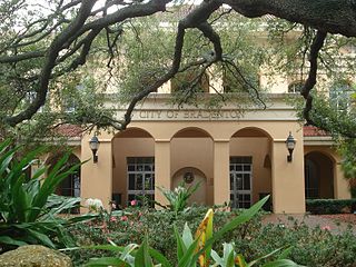
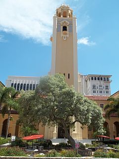
Bradenton is a city and the county seat of Manatee County, Florida, United States. As of the 2020 census,the city's population is 55,698.

Sarasota–Bradenton International Airport is located within three jurisdictions: Sarasota County, the city limits of Sarasota, and Manatee County, in the United States' state of Florida. Owned by the Sarasota Manatee Airport Authority, it is 3 miles (4.8 km) north of downtown Sarasota and 6 miles (9.7 km) south of Bradenton.

The Bob Graham Sunshine Skyway Bridge, often referred to as the Sunshine Skyway Bridge or simply the Skyway, is a cable-stayed bridge spanning the Lower Tampa Bay connecting St. Petersburg, Florida to Terra Ceia. The current Sunshine Skyway opened in 1987 and is the second bridge of that name on the site. It was designed by the Figg & Muller Engineering Group and built by the American Bridge Company. The bridge is considered the flagship bridge of Florida and serves as a gateway to Tampa Bay.

State College of Florida, Manatee–Sarasota (SCF) is a public college with campuses in the Manatee and Sarasota counties of Florida. Part of the Florida College System, it is designated a "state college" because it offers a greater number of bachelor's degrees than community colleges. SCF is accredited by the Southern Association of Colleges and Schools. Founded in 1957 as Manatee Junior College, it was known as Manatee Community College from 1985 to 2009.
State Road 777 is an 5.8-mile-long (9.3 km) state road near North Port, Florida, United States. SR 777 is locally known as River Road from Interstate 75 (I-75) south to its southern terminus at Tamiami Trail where it continues south as a county road.
Stretching 148 miles (238 km) across the Florida peninsula, State Road 70 spans five Florida counties and straddles the northern boundaries of two more. Its western terminus is at US 41 south of Bradenton ; its eastern terminus is an intersection of Virginia Avenue and South Fourth Street in Fort Pierce.
State Road 758 is an 5.4-mile-long (8.7 km) state road in Sarasota, Florida, United States. State Road 758 is locally known as Bee Ridge Road from Tamiami Trail east to its eastern terminus at Interstate 75 where it continues east as a county road.
State Road 789 is a 17.5-mile-long road along the Florida’s Gulf Coast that spans Bird Key, St. Armands Key, and Lido Key, in Sarasota; Longboat Key ; and Anna Maria Island. The southern terminus is the intersection of the John Ringling Causeway and the Tamiami Trail in Sarasota; the northern terminus is the intersection of Gulf Drive, North and Manatee Avenue., West in Holmes Beach. Much of the northernmost five miles (8 km) has been designated Bradenton Beach Scenic Highway.

The Sarasota metropolitan area is a metropolitan area located in Southwest Florida. The metropolitan area is defined by the Office of Management and Budget as the North Port–Sarasota–Bradenton metropolitan statistical area as a metropolitan statistical area (MSA) consisting of Manatee County and Sarasota County. The largest cities in the MSA are North Port and Sarasota and Bradenton. At the 2020 census, the MSA had a population of 833,716.
Interstate 75 (I-75) is a part of the Interstate Highway System and runs from the Hialeah–Miami Lakes border, a few miles northwest of Miami, to Sault Ste. Marie in the Upper Peninsula of Michigan. I-75 begins its national northward journey near Miami, running along the western parts of the Miami metropolitan area before traveling westward across Alligator Alley, resuming its northward direction in Naples, running along Florida's Gulf Coast, and passing the cities of Fort Myers, Punta Gorda, Venice, and Sarasota. The freeway passes through the Tampa Bay area before turning inward toward Ocala, Gainesville, and Lake City before leaving the state and entering Georgia. I-75 runs for 471 miles (758 km) in Florida, making it the longest Interstate in the state and also the longest in any state east of the Mississippi River. The Interstate's speed limit is 70 mph (110 km/h) for its entire length in Florida.
Lakewood Ranch is a planned community and census-designated place located in southeastern Manatee County and northeastern Sarasota County, Florida, United States consisting of approximately 31,000 acres (13,000 ha). It is part of the North Port-Bradenton-Sarasota, Florida Metropolitan Statistical Area.
State Road 329 (SR 329) was a short state highway traveling south and north through Gainesville, Florida. It comprised Main Street through Gainesville. The full length of the road extended from SR 331 to County Road 232 (CR 232). In the 1970s, the northern portion of the road, most of North Main Street, became County Road 329 (CR 329) while South Main Street was relinquished by the Florida Department of Transportation (FDOT) to the city. A small portion of the former state road in Gainesville is still maintained by the state as a portion of SR 20.
Friends of Seagate Inc. was founded in the late 1980s by Kafi Benz as a 501(c)(3) nonprofit organization in Sarasota, Florida. The historic preservation group lead local efforts protect historic property in the Sarasota-Bradenton area from commercial development. The group later expanded its scope to include environmental conservation. Its most notable project was the preservation of Seagate, the former home of Cincinnati, Ohio, industrialist Powel Crosley Jr. and his wife, Gwendolyn, and its later owners, Mabel and Freeman Horton. In 2002 the organization tried to secure Rus-in- Ur'be, an undeveloped parcel of land in the center of the Indian Beach Sapphire Shores neighborhood, as a local park; however, as of 2014, real estate developers intend to build condominium units at the site.
Several special routes of U.S. Route 41 exist, including three in Wisconsin. In order from south to north they are as follows.
