List of crossings of the River Derwent, Derbyshire

Last updated

This is a list of crossings of the Derbyshire Derwent , the principal river of Derbyshire in the Midlands of England.

Contents

Listed in the table are those crossings that have been identified from the first formal crossing at the packhorse bridge at Slippery Stones, in the upper Derwent valley, continuing through the Derwent Valley Mills heritage site to Derby, to the last crossing near Church Wilne upstream of Derwent Mouth where the Derwent meets the River Trent. [1]

Described by Defoe in 1726 as a "fury of a river" the Derwent could only be forded at a number of particular locations, which could still be impassable during winter floods. [2] Wooden bridges provided for a more reliable crossing, but were easily damaged by those same floods. The wooden bridge at Leadmill was destroyed before it was completed in the early 1700s. [3] Toad-Moor Bridge near Ambergate was rebuilt as Halfpenny Bridge by Francis Hurt in 1792, after being swept away in a flood of 1791. In the Candlemas flood of February 1795, the bridges at Belper and Whatstandwell were washed away, but were subsequently rebuilt soon after. [4] [5]

Glover in his History of the County of Derby of 1829 noted that there were a number of bridges, fords and a ferry across the Derwent. There were fords at Wilne Mills, Alvaston, Little Eaton and Ambaston, and a ferry at Matlock Bath. Wooden bridges were mentioned at Wilne Mills, Borrowash Mills and Exeter Bridge, downstream of which was a long wooden bridge for canal towing horses. Tolls were levied at Wilne Mills, Darley Abbey, and Milford, where there was also a chain-bridge for mill workers. He also recorded a number of county bridges and stone-arched bridges, the majority of which are now listed structures, and in some cases scheduled monuments. A number of these bridges were built by the local industrial families of the Derwent valley, including those of Hurt, Strutt and Evans. [4]

Crossings

Key to heritage status
StatusCriteria [6]
IGrade I listed. Bridge of exceptional interest, sometimes considered to be internationally important
II*Grade II* listed. Particularly important bridge of more than special interest
IIGrade II listed. Bridge of national importance and special interest
SM
Scheduled Monument. Nationally important archaeological bridge.
River orderNameImageLocation
Coordinates
CarriesDateHeritage
status
Notes
1 Slippery Stones packhorse bridge An infant River Derwent passes under the packhorse bridge at Slippery Stones - geograph.org.uk - 1140307.jpg Hope Woodlands
53°27′09″N1°44′48″W / 53.45260°N 1.74661°W / 53.45260; -1.74661 (Slippery Stones)
Footpath1672
(1959)
IIA 17th-century packhorse bridge that was relocated from Derwent village [7] [8]
2 Howden Dam Howden Dam - geograph.org.uk - 185883.jpg Howden Reservoir
53°26′00″N1°45′00″W / 53.43333°N 1.75000°W / 53.43333; -1.75000 (Howden Dam)
1912IIFor information [9]
3 Derwent Dam Derwent dam.jpg Derwent Reservoir
53°24′18″N1°44′30″W / 53.40503°N 1.74167°W / 53.40503; -1.74167 (Derwent Dam)
1916IIFor information [9]
4 Fairholmes Bridge Bridge at Fairholmes across the Derwent (geograph 3856165).jpg Derwent Reservoir
53°24′09″N1°44′32″W / 53.40260°N 1.74219°W / 53.40260; -1.74219 (Fairholmes Bridge)
Derwent Lane-Stone arch bridge [10]
5Ashopton Viaduct Ashopton Viaduct Arches - photoshopped 559803.jpg Ladybower Reservoir
53°22′29″N1°42′41″W / 53.37465°N 1.71147°W / 53.37465; -1.71147 (Ashopton Viaduct)
A571943-Concrete viaduct [10]
6 Ladybower Dam Ladybower Dam Wall - geograph.org.uk - 859996.jpg Ladybower Reservoir
53°21′57″N1°42′04″W / 53.3657°N 1.7011°W / 53.3657; -1.7011 (Ladybower Dam)
Footpath1943-Footway along dam wall [11]
7Yorkshire Bridge Yorkshire Bridge - geograph.org.uk - 470176.jpg Yorkshire Bridge
53°21′40″N1°42′14″W / 53.36123°N 1.70386°W / 53.36123; -1.70386 (Yorkshire Bridge)
Lydgate Lane1800sIIStone arch bridge [11] [12]
8Bamford Mill footbridge Footbridge over the Derwent (geograph 1922544).jpg Bamford
53°20′48″N1°41′39″W / 53.34659°N 1.69411°W / 53.34659; -1.69411 (Bamford Mill footbridge)
Footpath-Wooden footbridge at Bamford Mill [13]
9Water Lane bridge Water Lane, Bamford (geograph 1945624).jpg Bamford
53°20′34″N1°41′34″W / 53.34284°N 1.69273°W / 53.34284; -1.69273 (Water Lane bridge)
Water Lane-Minor road bridge [13]
10Railway bridge Hope Valley Railway (geograph 7605415).jpg Bamford
53°20′25″N1°41′32″W / 53.34014°N 1.69230°W / 53.34014; -1.69230 (Railway bridge)
Hope Valley line -Rail bridge [13]
11Mytham Bridge Mytham Bridge (geograph 3233323).jpg Bamford
53°20′21″N1°41′38″W / 53.33917°N 1.69388°W / 53.33917; -1.69388 (Mytham Bridge)
A6187-Stone arch bridge with adjacent footbridge [13]
12Hathersage stepping stones Stepping Stones, River Derwent - geograph.org.uk - 133468.jpg Hathersage
53°19′50″N1°40′31″W / 53.33048°N 1.67540°W / 53.33048; -1.67540 (Hathersage stepping stones)
Footpath-Between Offerton and Hathersage [14]
13Leadmill Bridge The River Derwent at Leadmill Bridge - geograph.org.uk - 1366671.jpg Hathersage
53°19′19″N1°39′04″W / 53.32187°N 1.65102°W / 53.32187; -1.65102 (Leadmill Bridge)
B600118th centuryIIStone arch bridge – widened in 1928 [14] [15]
14 Grindleford Bridge Grindleford Bridge Derbyshire England.jpg Grindleford
53°17′48″N1°38′03″W / 53.29675°N 1.63415°W / 53.29675; -1.63415 (Grindleford Bridge)
B6251II & SMStone arch bridge [16] [17]
15Froggatt Bridge Froggatt bridge - geograph.org.uk - 578978.jpg Froggatt
53°16′52″N1°38′09″W / 53.28116°N 1.63585°W / 53.28116; -1.63585 (Froggatt Bridge)
Minor Road19th century
SM
Stone arch bridge [16] [18]
16Froggatt New Bridge New Bridge, Calver, Derbyshire - geograph.org.uk - 63898.jpg Froggatt
53°16′28″N1°38′08″W / 53.27445°N 1.63565°W / 53.27445; -1.63565 (Froggatt New Bridge)
A625-Stone arch bridge [16]
17Calver Bridge River Derwent at Calver.jpg Calver
53°16′00″N1°37′53″W / 53.26657°N 1.63146°W / 53.26657; -1.63146 (Calver Bridge)
Minor road19th centuryII*Triple arched stone bridge [16] [19]
18Calver Bridge (A623) Baslow Road Bridge, Calver - 1 (geograph 3356523).jpg Calver
53°15′59″N1°37′55″W / 53.26625°N 1.63206°W / 53.26625; -1.63206 (Calver Bridge (A623))
A6231974-Modern bridge [16]
19 Baslow Bridge Baslow road bridge over river Derwent (geograph 3125886).jpg Baslow
53°14′52″N1°37′31″W / 53.24775°N 1.62527°W / 53.24775; -1.62527 (Baslow Bridge)
Minor road1608I & SMStone arch bridge with toll booth [20] [21]
20Devonshire Bridge River Derwent (geograph 4771147).jpg Baslow
53°14′46″N1°37′24″W / 53.24604°N 1.62337°W / 53.24604; -1.62337 (Devonshire Bridge)
A6191925-Bakewell Road bridge [20]
21Chatsworth Park Bridge Chatsworth Bridge.jpg Chatsworth
53°13′41″N1°36′58″W / 53.22800°N 1.61622°W / 53.22800; -1.61622 (Chatsworth Park Bridge)
Minor road1774IDesigned by James Paine, providing access to Chatsworth House [20] [22]
22One Arch Bridge Bridge over the River Derwent.jpg Chatsworth
53°12′45″N1°36′40″W / 53.21241°N 1.61106°W / 53.21241; -1.61106 (One Arch Bridge)
B60121760II* & SMAlso designed by James Paine, linking Edensor to Beeley [23] [24]
23Rowsley Viaduct Old railway viaduct over the River Derwent (geograph 3290713).jpg Rowsley
53°11′25″N1°37′06″W / 53.19038°N 1.61842°W / 53.19038; -1.61842 (Rowsley Viaduct)
Unused1862-Former railway viaduct [25]
24Rowsley Bridge Bridge over the Derwent at Rowsley - geograph.org.uk - 591671.jpg Rowsley
53°11′22″N1°37′02″W / 53.18957°N 1.61720°W / 53.18957; -1.61720 (Rowsley Bridge)
A6 15th centuryII* & SMStone arch bridge widened 1926 [26] [27]
25Darley Bridge Darley Bridge and River Derwent - geograph.org.uk - 1739358.jpg Darley Bridge
53°09′18″N1°35′49″W / 53.15508°N 1.59697°W / 53.15508; -1.59697 (Darley Bridge)
B505715th centuryII* & SMStone arch bridge [28] [29]
26Peak Rail bridge Bridge carrying Peak Rail line over the River Derwent - geograph.org.uk - 1241438.jpg Matlock
53°08′31″N1°34′08″W / 53.14200°N 1.56899°W / 53.14200; -1.56899 (Peak Rail bridge)
Peak Rail -Bridge 35 [30]
27Derwent Way bridge New A6 bridge over the Derwent (geograph 2336107).jpg Matlock
53°08′27″N1°33′53″W / 53.14074°N 1.56464°W / 53.14074; -1.56464 (Derwent Way bridge)
A6 2007-Modern A6 bridge [31]
28 Matlock Bridge Matlock Bridge - geograph.org.uk - 937223.jpg Matlock
53°08′16″N1°33′22″W / 53.13788°N 1.55622°W / 53.13788; -1.55622 (Matlock Bridge)
Former A6 route restored and widened 190415th centuryII* & SMStone arch bridge [32] [33]
29Hall Leys Park footbridge Bridge over the River Derwent (geograph 5861653).jpg Matlock
53°08′12″N1°33′15″W / 53.13659°N 1.55414°W / 53.13659; -1.55414 (Hall Leys Park footbridge)
Footpath-The gateway to the bridge shows flood heights in 1960 and 1965 [32]
30Railway bridge Matlock - railway bridge over River Derwent (geograph 2242669).jpg Matlock
53°08′05″N1°33′23″W / 53.13486°N 1.55643°W / 53.13486; -1.55643 (Railway bridge)
Derwent Valley Line -Rail bridge [32]
31Footbridge Matlock - footbridge to Pic Tor (Geograph-2242688-by-Dave-Bevis).jpg Matlock
53°08′00″N1°33′25″W / 53.13333°N 1.55684°W / 53.13333; -1.55684 (Footbridge)
Footpath-Dale Road to Pic Tor [32]
32Footbridge Slalom course on the river (geograph 5969587).jpg Matlock Bath
53°07′34″N1°33′35″W / 53.12600°N 1.55975°W / 53.12600; -1.55975 (Footbridge)
Footpath-Dale Road to High Tor [32]
33Footbridge Footbridge over the Derwent (geograph 2323218).jpg Matlock Bath
53°07′26″N1°33′28″W / 53.12386°N 1.55791°W / 53.12386; -1.55791 (Footbridge)
Footpath-Dale Road to cable car [32]
34Matlock Bath Bridge Matlock Bath Bridge (geograph 3912459).jpg Matlock Bath
53°07′19″N1°33′28″W / 53.12189°N 1.55786°W / 53.12189; -1.55786 (Matlock Bath Bridge)
Access road-Access road to Station Yard [32]
35Jubilee Bridge, Matlock Bath Jubilee Bridge 1887 - geograph.org.uk - 1639920.jpg Matlock Bath
53°07′17″N1°33′42″W / 53.12142°N 1.56154°W / 53.12142; -1.56154 (Jubilee Bridge, Matlock Bath)
Footpath1887-Footbridge [32]
36Derwent Gardens footbridge Footbridge in Derwent Gardens (geograph 4595667).jpg Matlock Bath
53°07′03″N1°33′36″W / 53.11752°N 1.55990°W / 53.11752; -1.55990 (Derwent Gardens footbridge)
Footpath1969-Modern footbridge linking Derwent Gardens to Lovers Walk; site of earlier Matlock ferry [32]
37Cromford Bridge Cromford Bridge - geograph.org.uk - 11273.jpg Cromford
53°06′40″N1°33′11″W / 53.11101°N 1.55310°W / 53.11101; -1.55310 (Cromford Bridge)
Mill Road15th centuryII* & SMStone arch bridge [34] [35]
38Cromford railway bridge Railway bridge over the River Derwent (geograph 3891047).jpg Cromford
53°06′43″N1°32′53″W / 53.11206°N 1.54809°W / 53.11206; -1.54809 (Cromford railway bridge)
Derwent Valley Line -Rail bridge [34]
39Access bridge (High peak junction) Vehicle Bridge over River Derwent - geograph.org.uk - 490094.jpg High Peak Junction
53°06′03″N1°31′54″W / 53.10074°N 1.53171°W / 53.10074; -1.53171 (Access bridge (High peak junction))
Access road-Access to sewage works [34]
40Footbridge Footbridge over River Derwent - geograph.org.uk - 490084.jpg High Peak Junction
53°06′02″N1°31′53″W / 53.10060°N 1.53127°W / 53.10060; -1.53127 (Footbridge)
Footpath-High Peak Junction [34]
41Leawood railway bridge Leawood railway bridge - geograph.org.uk - 1522398.jpg High Peak Junction
53°05′52″N1°31′44″W / 53.09778°N 1.52882°W / 53.09778; -1.52882 (Leawood railway bridge)
Derwent Valley Line -Rail bridge [34]
42Wigwell Aqueduct Wigwell Aqueduct - geograph.org.uk - 1522396.jpg High Peak Junction
53°05′49″N1°31′47″W / 53.09693°N 1.52983°W / 53.09693; -1.52983 (Wigwell Aqueduct)
Cromford Canal 1790s
SM
Partially collapsed during construction; rebuilt at William Jessop's own expense [34] [36]
43Railway bridge The 14.41 Matlock to Nottingham (geograph 6396985).jpg High Peak Junction
53°05′45″N1°31′19″W / 53.09595°N 1.52191°W / 53.09595; -1.52191 (Railway bridge)
Derwent Valley Line -Rail bridge [37]
44Homesford footbridge Footbridge over the River Derwent (geograph 3085087).jpg Whatstandwell
53°05′40″N1°30′51″W / 53.09447°N 1.51415°W / 53.09447; -1.51415 (Homesford footbridge)
Footpath-Combined foot and pipe bridge [37]
45Railway bridge Railway Bridge over The Derwent - geograph.org.uk - 1354699.jpg Whatstandwell
53°05′23″N1°30′25″W / 53.08979°N 1.50692°W / 53.08979; -1.50692 (Railway bridge – Whatstandwell)
Derwent Valley Line -Rail bridge [37]
46Whatstandwell Bridge A Swollen Derwent Passes Under The Bridge - geograph.org.uk - 994005.jpg Whatstandwell
53°05′08″N1°30′25″W / 53.08549°N 1.50704°W / 53.08549; -1.50704 (Whatstandwell Bridge)
A6 1796IIStone arch bridge [37] [38]
47Oak Hurst mills bridge Ambergate
53°04′00″N1°29′31″W / 53.06674°N 1.49193°W / 53.06674; -1.49193 (Oak Hurst mills bridge)
Access road-Access bridge [39]
48Halfpenny Bridge Ambergate Halfpenny Bridge Derbyshire England.jpg Ambergate
53°03′34″N1°29′02″W / 53.05942°N 1.48389°W / 53.05942; -1.48389 (Halfpenny Bridge)
Holly Lane1792IIAlso known as Toad-Moor bridge, built as a toll bridge by Francis Hurt [39] [40]
49Derwent Viaduct Ambergate railway bridge over River Derwent Derbyshire England.jpg Ambergate
53°03′24″N1°28′58″W / 53.05672°N 1.48288°W / 53.05672; -1.48288 (Derwent Viaduct)
Midland Main Line 1840II*Skewed rail bridge [39] [41]
50Railway bridge Wyver Lane - View towards the Derwent and Railway - geograph.org.uk - 1193001.jpg Belper
53°02′45″N1°29′06″W / 53.0458°N 1.4849°W / 53.0458; -1.4849 (Railway bridge)
Midland Main Line -Rail bridge [42]
51Railway bridge Belper- crossing the Derwent (geograph 5492130).jpg Belper
53°01′56″N1°28′59″W / 53.0321°N 1.4830°W / 53.0321; -1.4830 (Railway bridge)
Midland Main Line -Rail bridge [42]
52Belper Bridge Belper - road bridge and North Mill from River Derwent path - geograph.org.uk - 630207.jpg Belper
53°01′46″N1°29′14″W / 53.02936°N 1.48725°W / 53.02936; -1.48725 (Belper Bridge)
Bridge Foot1798IITripled arched bridge [42] [43]
53Belper Meadows footbridge The Derwent Passes under a Small Bridge - geograph.org.uk - 1350568.jpg Belper
53°01′30″N1°29′30″W / 53.02505°N 1.49173°W / 53.02505; -1.49173 (Belper Meadows footbridge)
Footpath-Access bridge [42]
54Belper sewage works bridge Sewage Works Access Road over River Derwent - geograph.org.uk - 736139.jpg Belper
53°00′58″N1°29′06″W / 53.01619°N 1.48501°W / 53.01619; -1.48501 (Belper sewage works bridge)
Access road-Access bridge [42]
55Swainsley Railway bridge Swainsley River Derwent Viaduct (geograph 5324465).jpg Belper
53°00′40″N1°29′04″W / 53.01125°N 1.48433°W / 53.01125; -1.48433 (Swainsley Railway bridge)
Midland Main Line -Steel rail bridge [42]
56Milford Bridge Milford Bridge - geograph.org.uk - 1117824.jpg Milford
53°00′08″N1°28′42″W / 53.00231°N 1.47840°W / 53.00231; -1.47840 (Milford Bridge)
A6 1790IIStone arch bridge [44]
57Milford footbridge Milford - Leaving the Riverside Garden Centre (over the River Derwent) (geograph 2421660).jpg Milford
53°00′03″N1°28′46″W / 53.00096°N 1.47936°W / 53.00096; -1.47936 (Milford footbridge)
Footpath-Garden centre access [44] [45]
58Moscow Farm bridge Milford
52°59′45″N1°28′53″W / 52.99587°N 1.48139°W / 52.99587; -1.48139 (Moscow Farm bridge)
Access road-Access bridge [44]
59Duffield Church Bridge Duffield - Makeney Road bridge over River Derwent (geograph 2828936).jpg Duffield
52°58′58″N1°28′47″W / 52.98290°N 1.47961°W / 52.98290; -1.47961 (Duffield Church Bridge)
Makeney RoadProbable 16th centuryII & SMStone arch bridge [44] [46]
60Burley Railway Bridge The River Derwent near Little Eaton (geograph 2964793).jpg Little Eaton
52°58′11″N1°28′17″W / 52.96981°N 1.47143°W / 52.96981; -1.47143 (Burley Railway Bridge)
Midland Main Line -Rail bridge [47]
61Allestree Ford Bridge Allestree Ford Bridge - geograph.org.uk - 1012764.jpg Allestree
52°57′27″N1°27′58″W / 52.95760°N 1.46619°W / 52.95760; -1.46619 (Allestree Ford Bridge)
Ford Lane-Former ford at this point [47]
62Allestree A38 Bridge The Derwent from Allestree Ford Bridge - geograph.org.uk - 1012348.jpg Allestree
52°57′20″N1°28′03″W / 52.95568°N 1.46759°W / 52.95568; -1.46759 (Allestree A38 Bridge)
Abbey Hill-Dual carriageway bridge [47]
63Darley Abbey toll bridge The temporary footbridge (geograph 7306788).jpg Darley Abbey
52°56′36″N1°28′33″W / 52.94332°N 1.47584°W / 52.94332; -1.47584 (Darley Abbey toll bridge)
Haslams Lane-The existing toll bridge was deemed unsafe for both foot and road traffic in 2022, and was subsequently replaced by a temporary pedestrian footbridge known as Walter's Walkway later that same year. [48] [47]
64 Handyside Bridge Handyside Bridge - geograph.org.uk - 1024114.jpg Derby
52°55′51″N1°28′39″W / 52.93092°N 1.47747°W / 52.93092; -1.47747 (Handyside Bridge)
Footpath1878IIFormer GNR railway bridge [49] [50]
65St Marys Bridge Derby - St Marys Bridge (geograph 3243722).jpg Derby
52°55′38″N1°28′31″W / 52.92716°N 1.47519°W / 52.92716; -1.47519 (St Marys Bridge)
Minor road1793II* & SMDesigned by Thomas Harrison, it replaced an earlier medieval bridge; adjacent is St Mary's Bridge Chapel. [49] [51]
66Causey Bridge Under Causey Bridge - geograph.org.uk - 1026489.jpg Derby
52°55′36″N1°28′31″W / 52.92667°N 1.47521°W / 52.92667; -1.47521 (Causey Bridge)
Saint Alkmunds Way1972-Dual carriageway bridge [49]
67 Cathedral Green Footbridge Cathedral Green Footbridge - Derby.jpg Derby
52°55′31″N1°28′31″W / 52.92525°N 1.47522°W / 52.92525; -1.47522 (Cathedral Green footbridge)
Footpath2009-Swing bridge [52]
68 Exeter Bridge Exeter Bridge.jpg Derby
52°55′26″N1°28′26″W / 52.92397°N 1.47382°W / 52.92397; -1.47382 (Exeter Bridge)
Derwent Street1929-1920s road bridge, replaced earlier wooden bridge [49]
69Holmes Bridge The Derwent from Exeter Bridge (geograph 4180040).jpg Derby
52°55′24″N1°28′11″W / 52.92343°N 1.46968°W / 52.92343; -1.46968 (Holmes Bridge)
A6011972-Dual carriageway bridge [49]
70Bass Recreation Ground footbridge Foot Bridge Spanning the Derwent - geograph.org.uk - 1058254.jpg Derby
52°55′17″N1°27′57″W / 52.92139°N 1.46592°W / 52.92139; -1.46592 (Bass Recreation Ground footbridge)
Footpath-Modern footbridge [49]
71Derwent Bridge Derwent Bridge 3479.jpg Derby
52°55′10″N1°27′50″W / 52.91952°N 1.46376°W / 52.91952; -1.46376 (Derwent Bridge)
Midland Main Line 1840IISkewed rail bridge, also known as Five Arches [49] [53]
72Derwent Parade bridge Bridge carrying Derwent Parade over the Derwent - geograph.org.uk - 1058467.jpg Pride Park
52°55′03″N1°26′35″W / 52.91761°N 1.44309°W / 52.91761; -1.44309 (Derwent Parade bridge)
Derwent Parade-Modern road bridge [49]
73Railway bridge Pride Park Railway over the River Derwent - geograph.org.uk - 1059491.jpg Pride Park
52°54′40″N1°26′26″W / 52.91104°N 1.44067°W / 52.91104; -1.44067 (Railway bridge Pride Park)
Midland Main Line - Midland Main Line [49]
74Raynesway Bridge The A5111 crosses the River Derwent - geograph.org.uk - 1022741.jpg Derby
52°54′17″N1°25′50″W / 52.90467°N 1.43049°W / 52.90467; -1.43049 (Raynesway Bridge)
A51111938-A5111 [54]
75Waste Incinerator bridge Bridge over the Derwent at Derby (geograph 2524345).jpg Derby
52°54′16″N1°25′39″W / 52.90440°N 1.42760°W / 52.90440; -1.42760 (Waste Incinerator bridge)
Access road-Access to incinerator [54]
76Fernhook Avenue bridge New Bridge over the Derwent - geograph.org.uk - 1103140.jpg Derby
52°54′10″N1°24′42″W / 52.90280°N 1.41177°W / 52.90280; -1.41177 (Fernhook Avenue bridge)
Access road2009-Access to Derby commercial park [55]
77Access bridge Bridge Over the Derwent - geograph.org.uk - 1023431.jpg Borrowash
52°54′06″N1°23′24″W / 52.90161°N 1.39012°W / 52.90161; -1.39012 (Access bridge)
Access road-Borrowash [56]
78Borrowash Bridge Borrowash Bridge - geograph.org.uk - 1012668.jpg Borrowash
52°54′06″N1°23′03″W / 52.90162°N 1.38411°W / 52.90162; -1.38411 (Borrowash Bridge)
B5010-Links Borrowash to Elvaston [56]
79Ambaston Ford The former Nooning ford, looking upstream (geograph 1821925).jpg Ambaston
52°53′36″N1°21′36″W / 52.89325°N 1.36010°W / 52.89325; -1.36010 (Ambaston Ford)
Disused-Disused ford between Ambaston and Nooning Lane [56]
80Wilne footbridge Footbridge at Great Wilne - geograph.org.uk - 11913.jpg Church Wilne
52°52′43″N1°19′47″W / 52.87868°N 1.32974°W / 52.87868; -1.32974 (Wilne footbridge)
Footpath1960s-Replaced earlier toll bridge upstream at Wilne mills [57]
81 Derwent Mouth Derwent Mouth - geograph.org.uk - 1541622.jpg Great Wilne
52°52′22″N1°19′11″W / 52.87291°N 1.31980°W / 52.87291; -1.31980 (Derwent Mouth)
-Confluence with the Trent [57]

Bibliography

Related Research Articles

<span class="mw-page-title-main">River Derwent, Derbyshire</span> River in Derbyshire, England

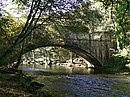
The Derwent is a river in Derbyshire, England. It is 50 miles (80 km) long and is a tributary of the River Trent, which it joins south of Derby. Throughout its course, the river mostly flows through the Peak District and its foothills.

<span class="mw-page-title-main">Matlock, Derbyshire</span> County town of Derbyshire

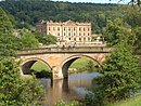
Matlock is the county town of Derbyshire, England. It is in the south-eastern part of the Peak District, with the National Park directly to the west. The spa resort of Matlock Bath is immediately south of the town as well as Cromford lying further south still. The civil parish of Matlock Town had a population in the 2021 UK census of 10,000.

<span class="mw-page-title-main">Whatstandwell</span> Human settlement in England

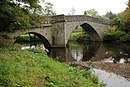
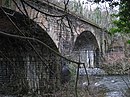
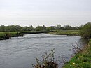
Whatstandwell is a village on the River Derwent in the Amber Valley district of Derbyshire, England. It is about five miles south of Matlock and about four miles north of Belper. Whatstandwell railway station is on the Derby–Matlock Derwent Valley Line, and the A6 trunk road crosses the River Derwent in the village. Most of the population is included in the civil parish of Crich but the village may be said to extend across the Derwent into the parish of Alderwasley.

<span class="mw-page-title-main">Cromford</span> Village in Derbyshire, England

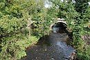
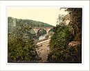
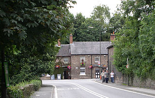
Cromford is a village and civil parish in Derbyshire, England, in the valley of the River Derwent between Wirksworth and Matlock. It is 17 miles (27 km) north of Derby, 2 miles (3.2 km) south of Matlock and 1 mile (1.6 km) south of Matlock Bath. It is first mentioned in the 11th-century Domesday Book as Crumforde, a berewick of Wirksworth, and this remained the case throughout the Middle Ages. The population at the 2011 Census was 1,433. It is principally known for its historical connection with Richard Arkwright and the nearby Cromford Mill, which he built outside the village in 1771. Cromford is in the Derwent Valley Mills World Heritage Site.

<span class="mw-page-title-main">History of Derbyshire</span> History of the county of Derbyshire in England

The history of Derbyshire can be traced back to human settlement since the last Ice Age, over 10,000 years ago. The county of Derbyshire in England dates back to the 11th century.

<span class="mw-page-title-main">Derwent Valley line</span> Matlock to Derby railway line

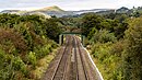
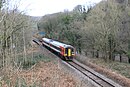
The Derwent Valley line is a railway line from Derby to Matlock in Derbyshire.

<span class="mw-page-title-main">Cromford railway station</span> Railway station in Derbyshire, England

Cromford railway station is a Grade II listed railway station owned by Network Rail and managed by East Midlands Railway. It is located in the village of Cromford in Derbyshire, England. The station is on the Derwent Valley Line 15+12 miles (24.9 km) north of Derby towards Matlock.

<span class="mw-page-title-main">Whatstandwell railway station</span> Railway station in Derbyshire, England

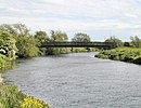
Whatstandwell railway station is a railway station owned by Network Rail and managed by East Midlands Railway. It serves the villages of Whatstandwell and Crich Carr in Derbyshire, England. The station is located on the Derwent Valley Line from Derby to Matlock.

<span class="mw-page-title-main">Matlock Bath railway station</span> Railway station in Derbyshire, England

Matlock Bath railway station is a Grade II listed railway station owned by Network Rail and managed by East Midlands Railway. It is located in the village of Matlock Bath in Derbyshire, England. The station is unmanned by rail staff and is located on the Derwent Valley Line, 16.25 miles (26.15 km) north of Derby towards Matlock.

<span class="mw-page-title-main">Matlock railway station</span> Railway station in Derbyshire, England

Matlock railway station is owned by Network Rail and managed by East Midlands Railway; it serves the Derbyshire Dales county town of Matlock, Derbyshire, England. The station is the terminus of both the Derwent Valley Line from Derby and Peak Rail who operate heritage services to Rowsley South. Both lines are formed from portions of the Midland Railway's former main line to Manchester Central. Through running is technically possible but is not done in normal service.

<span class="mw-page-title-main">Draycott and Church Wilne</span> Civil parish in England

Draycott and Church Wilne is a civil parish within the Borough of Erewash, which is in the county of Derbyshire, England. Partially built up and otherwise rural, its population was 3,090 residents in the 2011 census. The parish is 100 miles (160 km) north west of London, 5+12 miles (8.9 km) south east of the county city of Derby, and 3 miles (4.8 km) west of the nearest market town of Long Eaton. It shares a boundary with the parishes of Breaston, Elvaston, Hopwell, Ockbrook and Borrowash, Risley and Shardlow and Great Wilne.

<span class="mw-page-title-main">Matlock Bridge</span> Road bridge over river in centre of Matlock town

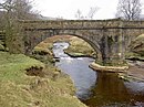
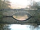
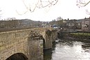
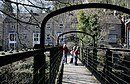
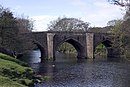
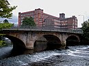
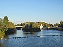
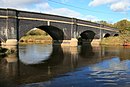
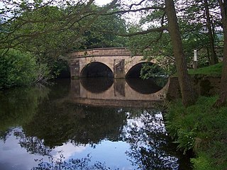
Matlock Bridge also known as Derwent Bridge, is a stone bridge spanning the River Derwent in Matlock town centre, Derbyshire, England. The bridge dates back to the 15th century, and is a Grade II* listed structure.

<span class="mw-page-title-main">Derwent Valley Heritage Way</span> Long distance footpath in England

The Derwent Valley Heritage Way (DVHW) is a 55 miles (89 km) waymarked footpath along the Derwent Valley through the Peak District. The walk starts from Ladybower Reservoir in the Peak District National Park via Chatsworth, the scenery around the Derbyshire Dales, and through the Derwent Valley Mills World Heritage Site. It follows the Riverside Path through Derby and continues onwards to the historic inland port of Shardlow. Journey's end is at Derwent Mouth where the River Derwent flows into the River Trent.

<span class="mw-page-title-main">Handyside Bridge</span> Bridge in Derby, England

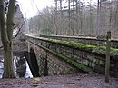
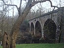
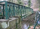
Handyside Bridge, also known as Derwent Bridge, is a former railway bridge in Darley Abbey, Derbyshire, England which was converted to a foot bridge in 1976 following closure of the railway in 1968.

<span class="mw-page-title-main">Highlow</span> Civil parish in England

Highlow is a civil parish within the Derbyshire Dales district, in the county of Derbyshire, England. Largely rural, Highlow's population is reported with the population of neighbouring parishes for a total of 585 residents in 2011. It is 140 miles (230 km) north-west of London, 28 miles (45 km) north-west of the county city of Derby, and 7+12 miles (12.1 km) north of the nearest market town of Bakewell. Highlow is wholly within the Peak District national park, and shares a border with the parishes of Abney and Abney Grange, Eyam, Foolow, Grindleford, Hathersage as well as Offerton. There are nine listed buildings in Highlow.

Draycott and Church Wilne is a civil parish in the Borough of Erewash district of Derbyshire, England. The parish contains 17 listed buildings that are recorded in the National Heritage List for England. Of these, one is listed at Grade I, the highest of the three grades, and the others are at Grade II, the lowest grade. The parish contains the village of Draycott, the hamlet of Church Wilne, and the surrounding countryside. Most of the listed buildings are mill buildings in Draycott village, and the others consist of houses and associated structures, a church, a milepost, and three railway bridges.

Sandiacre is a civil parish in the Borough of Erewash in Derbyshire, England. The parish contains ten listed buildings that are recorded in the National Heritage List for England. Of these, one is listed at Grade I, the highest of the three grades, and the others are at Grade II, the lowest grade. The parish contains the village of Sandiacre and the surrounding area. The listed buildings consist of a church, a village lock-up and pound, two bridges crossing the Erewash Canal, a house, a milepost, a former lace factory and its office block, and two pairs of almshouses.

Shardlow and Great Wilne is a civil parish in the South Derbyshire district of Derbyshire, England. The parish contains 48 listed buildings that are recorded in the National Heritage List for England. Of these, one is listed at Grade II*, the middle of the three grades, and the others are at Grade II, the lowest grade. The parish contains the village of Shardlow, the smaller village of Great Wilne, and the surrounding area. Shardlow is at the southern end of the Trent and Mersey Canal, and a number of buildings relating to the canal are listed, including warehouses, mileposts, a bridge and a lock. Most of the other listed buildings are houses, cottages and associated structures, farmhouses and farm buildings. The rest of the listed buildings include public houses, a church and associated structures including a war memorial, a road milepost, the sign from a former toll house, and a school.

References

  1. Philip's 1997, pp. 14–235.
  2. Cooper 1983, p. 166.
  3. Cooper 1983, p. 167.
  4. 1 2 Glover 1829, p. 259.
  5. Philosophical Magazine, Comprehending the Various Branches of Science, the Liberal and Fine Arts, Agriculture, Manifactures, and Commerce. 1812. pp. 206–.
  6. Listed Buildings, English Heritage, archived from the original on 22 December 2012, retrieved 22 April 2011
  7. Philip's 1997, p. 14.
  8. Historic England. "Slippery Stones (1087992)". National Heritage List for England . Retrieved 17 January 2019.
  9. 1 2 Philip's 1997, p. 21.
  10. 1 2 Philip's 1997, p. 30.
  11. 1 2 Philip's 1997, p. 39.
  12. Historic England. "Yorkshire Bridge (1087856)". National Heritage List for England . Retrieved 17 January 2019.
  13. 1 2 3 4 Philip's 1997, p. 40.
  14. 1 2 Philip's 1997, p. 52.
  15. Historic England. "Leadmill Bridge (1109800)". National Heritage List for England . Retrieved 17 January 2019.
  16. 1 2 3 4 5 Philip's 1997, p. 72.
  17. Historic England. "Grindleford Bridge (1007059)". National Heritage List for England . Retrieved 17 January 2019.
  18. Historic England. "Froggatt Bridge (1007056)". National Heritage List for England . Retrieved 17 January 2019.
  19. Historic England. "Calver Bridge (1088212)". National Heritage List for England . Retrieved 17 January 2019.
  20. 1 2 3 Philip's 1997, p. 91.
  21. Historic England. "Baslow Bridge (1088195)". National Heritage List for England . Retrieved 17 January 2019.
  22. Historic England. "Chatsworth Park Bridge (1049093)". National Heritage List for England . Retrieved 17 January 2019.
  23. Philip's 1997, p. 111.
  24. Historic England. "One Arch Bridge (1052356)". National Heritage List for England . Retrieved 17 January 2019.
  25. Philip's 1997, p. 110.
  26. Philip's 1997, p. 126.
  27. Historic England. "Rowsley Bridge (1263843)". National Heritage List for England . Retrieved 17 January 2019.
  28. Philip's 1997, p. 127.
  29. Historic England. "Darley Bridge (1248041)". National Heritage List for England . Retrieved 17 January 2019.
  30. Philip's 1997, p. 142.
  31. Roberts, Alan (15 August 2012). Matlock & Matlock Bath Through Time. Amberley Publishing Limited. pp. 84–. ISBN   978-1-4456-2948-3.
  32. 1 2 3 4 5 6 7 8 9 Philip's 1997, p. 143.
  33. Historic England. "Matlock Bridge (1247890)". National Heritage List for England . Retrieved 17 January 2019.
  34. 1 2 3 4 5 6 Philip's 1997, p. 155.
  35. Historic England. "Cromford Bridge (1263846)". National Heritage List for England . Retrieved 17 January 2019.
  36. Historic England. "Wigwell Aqueduct (1007040)". National Heritage List for England . Retrieved 17 January 2019.
  37. 1 2 3 4 Philip's 1997, p. 156.
  38. Historic England. "Whatstandwell Bridge (1335314)". National Heritage List for England . Retrieved 17 January 2019.
  39. 1 2 3 Philip's 1997, p. 167.
  40. Historic England. "Halfpenny Bridge (1109020)". National Heritage List for England . Retrieved 17 January 2019.
  41. Historic England. "Derwent Viaduct (1417625)". National Heritage List for England . Retrieved 17 January 2019.
  42. 1 2 3 4 5 6 Philip's 1997, p. 178.
  43. Historic England. "Belper Bridge (1087394)". National Heritage List for England . Retrieved 17 January 2019.
  44. 1 2 3 4 Philip's 1997, p. 191.
  45. Historic England. "Milford Bridge (1099189)". National Heritage List for England . Retrieved 17 January 2019.
  46. Historic England. "Duffield Church Bridge (1158235)". National Heritage List for England . Retrieved 17 January 2019.
  47. 1 2 3 4 Philip's 1997, p. 205.
  48. "Temporary footbridge – Walter's Walkway". Derby City Council. 2023. Retrieved 10 November 2023.
  49. 1 2 3 4 5 6 7 8 9 Philip's 1997, p. 219.
  50. Historic England. "Handyside Bridge (1215438)". National Heritage List for England . Retrieved 17 January 2019.
  51. Historic England. "St Marys Bridge (1215897)". National Heritage List for England . Retrieved 17 January 2019.
  52. "New bridge for Derby". BBC. Retrieved 28 January 2019.
  53. Historic England. "Derwent Bridge (1417807)". National Heritage List for England . Retrieved 17 January 2019.
  54. 1 2 Philip's 1997, p. 220.
  55. "New Raynesway bridge". Cass Hayward. 2009. Retrieved 27 January 2019.
  56. 1 2 3 Philip's 1997, p. 234.
  57. 1 2 Philip's 1997, p. 235.