Related Research Articles

The Ring of Fire is a tectonic belt, about 40,000 km (25,000 mi) long and up to about 500 km (310 mi) wide, which circumscribes the Pacific Ocean. It contains between 750 and 915 volcanoes, around two-thirds of the world total, and 90% of the world's earthquakes, including 81% of its largest, take place within the belt.

The Juan de Fuca Plate is a small tectonic plate (microplate) generated from the Juan de Fuca Ridge that is subducting beneath the northerly portion of the western side of the North American Plate at the Cascadia subduction zone. It is named after the explorer of the same name. One of the smallest of Earth's tectonic plates, the Juan de Fuca Plate is a remnant part of the once-vast Farallon Plate, which is now largely subducted underneath the North American Plate.

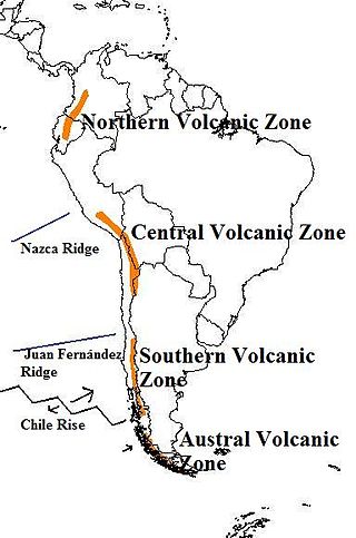
The Andean Volcanic Belt is a major volcanic belt along the Andean cordillera in Argentina, Bolivia, Chile, Colombia, Ecuador, and Peru. It is formed as a result of subduction of the Nazca Plate and Antarctic Plate underneath the South American Plate. The belt is subdivided into four main volcanic zones which are separated by volcanic gaps. The volcanoes of the belt are diverse in terms of activity style, products, and morphology. While some differences can be explained by which volcanic zone a volcano belongs to, there are significant differences within volcanic zones and even between neighboring volcanoes. Despite being a type location for calc-alkalic and subduction volcanism, the Andean Volcanic Belt has a broad range of volcano-tectonic settings, as it has rift systems and extensional zones, transpressional faults, subduction of mid-ocean ridges and seamount chains as well as a large range of crustal thicknesses and magma ascent paths and different amounts of crustal assimilations.
The 1906 Ecuador–Colombia earthquake occurred at 10:36:10 (UTC+5) on Wednesday January 31, 1906 off the coast of Ecuador, near Esmeraldas. The earthquake had a moment magnitude of 8.8 and triggered a destructive tsunami that caused at least 500 casualties on the coast of Colombia.
The 1932 Ierissos earthquake occurred at 19:20 on 26 September. It caused severe damage in Ierissos, Greece and the surrounding part of the Chalkidiki peninsula, with 161–491 casualties reported.
The 1949 Ambato earthquake was the deadliest earthquake in the Western Hemisphere in five years. On August 5, 1949, it struck Ecuador's Tungurahua Province southeast of its capital Ambato and killed 5,050 people. Measuring 6.4 on the Ms scale, it originated from a hypocenter 15 km beneath the surface. The nearby villages of Guano, Patate, Pelileo, and Pillaro were destroyed, and the city of Ambato suffered heavy damage. The earthquake flattened buildings and subsequent landslides caused damage throughout the Tungurahua, Chimborazo, and Cotopaxi Provinces. It disrupted water mains and communication lines and opened a fissure into which the small town of Libertad sank. Moderate shaking from the event extended as far away as Quito and Guayaquil.
The 1797 Riobamba earthquake occurred at 12:30 UTC on 4 February. It devastated the city of Riobamba and many other cities in the Interandean valley, causing between 6,000–40,000 casualties. It is estimated that seismic intensities in the epicentral area reached at least XI (Extreme) on the Mercalli intensity scale, and that the earthquake had a magnitude of 7.6–8.3, the most powerful historical event known in Ecuador. The earthquake was studied by Prussian geographer Alexander von Humboldt, when he visited the area in 1801–1802.

The 1868 Ecuador earthquakes occurred at 19:30 UTC on August 15 and 06:30 UTC on 16 August 1868. They caused severe damage in the northeastern part of Ecuador and in southwestern Colombia. They had an estimated magnitude of 6.3 and 6.7 and together caused up to 70,000 casualties. The earthquake of 15 August occurred near El Ángel, Carchi Province, close to the border with Colombia, while that of August 16 occurred near Ibarra in Imbabura Province. Reports of these earthquakes are often confused with the effects of the earthquake of 13 August at Arica.
The 1998 Bahía de Caráquez earthquake occurred on August 4 at 13:59 local time with a magnitude Mw 7.2. The epicenter was located at 10 km north of Bahía de Caráquez, about 190 km NNW of Guayaquil, and about 215 km W of Quito, Ecuador. The intensity in Bahía de Caráquez reached MM VIII. In Bahía de Caráquez, electricity, telephone, and water services disrupted, and many buildings were damaged. It was felt strongly in Guayaquil and Quito and could be felt in much of Ecuador and in Cali, Colombia. An Mw 5.4 foreshock occurred 1 hour and 24 minutes before the main shock and hence alerted many people. The Nazca Plate is subducting beneath the South American Plate near the Ecuadorian coast. This earthquake was a shallow thrust earthquake in this subduction zone.
The 1953 Tumbes earthquake occurred on December 12 at 12:31:29 local time near the border between Peru and Ecuador. The shock had a moment magnitude of 7.5, a maximum Mercalli Intensity of VIII (Severe), and occurred in the northwestern offshore area of Tumbes, Peru.
The 1979 Tumaco earthquake occurred at 02:59 local time on 12 December with a moment magnitude of 8.2 and a maximum Mercalli intensity of IX (Violent). The epicenter was just offshore from the border between Ecuador and Colombia, near the port city of Tumaco. It triggered a major tsunami, which was responsible for most of the estimated 300–600 deaths. The hardest hit area was Colombia's Nariño Department.
The 1992 Murindó earthquake occurred on October 18 at 15:11 UTC with an epicenter in the Department of Chocó, northern Colombia. The shallow magnitude 7.2 earthquake struck northwest of the town of Murindó, killing ten and injured more than a hundred. Thirty-three municipalities were severely damaged.
An earthquake measuring Mw 8.0 struck Peru and the surrounding areas on 26 May 2019 at 02:41 local time. It had a maximum perceived intensity of VII on the Modified Mercalli intensity scale in the towns of Yurimaguas and Lagunas. Two people died and a further 30 were injured. It was the strongest earthquake in 2019 by magnitude.
The 1942 Ecuador earthquake or the Guayaquil earthquake occurred on 13 May at 9:06 or 9:13 pm local time with a moment magnitude of Mw 7.9. The temblor struck the coastal (Esmeraldas) region of Manabí Province, Ecuador. It caused damage mainly to cities like Guayaquil, Portoviejo and Guaranda. More than 300 people were killed and the total cost of damage was about US$2.5 million. Ecuador's largest city Guayaquil was the most affected despite the significant distantce from the epicenter. Many reinforced concrete structures in a particular area in the city were completely destroyed, contributing to fatalities.

An earthquake occurred off the coast of the Alaska Peninsula on July 28, 2021, at 10:15 p.m. local time. The large megathrust earthquake had a moment magnitude of 8.2 according to the United States Geological Survey (USGS). A tsunami warning was issued by the National Oceanic and Atmospheric Administration (NOAA) but later cancelled. The mainshock was followed by a number of aftershocks, including three that were of magnitude 5.9, 6.1 and 6.9 respectively.
The 1950 Calama earthquake occurred near the Argentina–Chile border with an epicenter near Calama, Chile in the Atacama Desert on December 9. The event had a hypocenter depth of 113.9 km, beneath the Caichinque volcanic complex. It measured magnitude Mw 8.2 on the moment magnitude scale, making it the largest intermediate depth earthquake ever recorded on Chilean soil. One person was killed and an unspecified number of people were injured in Calama.

A major earthquake struck northern Peru on November 28, 2021, 5:52 a.m. local time with a magnitude of 7.5 on the moment magnitude scale between the Amazonas and Loreto departments of Peru. A maximum Modified Mercalli intensity (MMI) of VII was reported in the town of Santa Maria de Nieva according to the Geological Institute of Peru.
The 1657 Concepción earthquake occurred on March 15 at 20:00 local time off the coast of Concepción, Biobío Region in the Spanish Empire. The earthquake caused severe damage along the coast, and generated a large tsunami in the Bay of Concepción. At least 40 people were killed, the majority due to drowning from the tsunami. The town of Concepción was the hardest hit, with the earthquake and tsunami totally destroying it.
A strong earthquake struck southern Ecuador on 18 March 2023. It measured 6.8 on the moment magnitude scale, and struck with a hypocenter 65.8 km (40.9 mi) deep. The epicenter was located in the Gulf of Guayaquil, just off the coast of the canton of Balao and some 80 kilometres (50 mi) south of the city of Guayaquil. It caused major damage, with 446 injuries and 16 fatalities in the provinces of El Oro, Azuay and Guayas, while two additional fatalities and dozens of injuries were reported in Peru.
References
- ↑ Gutscher, M.-A.; Malavieille, J.; Lallemand, S.; Collot, J.-Y. (1999). "Tectonic segmentation of the North Andean margin: impact of the Carnegie Ridge collision" (PDF). Earth and Planetary Science Letters. 168 (3–4): 255–270. Bibcode:1999E&PSL.168..255G. doi:10.1016/S0012-821X(99)00060-6 . Retrieved 24 August 2010.
- ↑ Eguez, A.; Alvarado A.; Yepes H.; Machette M.N.; Costa C.; Dart R.L. "Database and Map of Quaternary faults and folds of Ecuador and its offshore regions" (PDF). USGS Open-File Report 03-289. pp. 2–3. Retrieved 22 August 2010.
- 1 2 USGS (20 August 2010). "Magnitude 7.1 - ECUADOR 12 August 2010 11:54:16 UTC" . Retrieved 24 August 2010.
- ↑ Legrand, D.; Villagómez D.; Yepes H.; Calahorrano A. (2004). "Multifractal dimension and b value analysis of the 1998–1999 Quito swarm related to Guagua Pichincha volcano activity, Ecuador". Journal of Geophysical Research. 109 (B01307). Bibcode:2004JGRB..10901307L. doi: 10.1029/2003JB002572 . Retrieved 24 August 2010.
- ↑ NGDC. "Comments for the Significant Earthquake" . Retrieved 20 August 2010.
- ↑ Giesecke, A.; Capera A.A.G.; Leschiutta I.; Migliorini E.; Valverde L.R. (2004). "The CERESIS earthquake catalogue and database of the Andean Region: background, characteristics and examples of use" (PDF). Annals of Geophysics. 47 (2/3): 421–435. Retrieved 22 August 2010.
- ↑ Mendoza, C.; Dewey J.W. (1984). "Seismicity associated with the great Colombia-Ecuador earthquakes of 1942, 1958, and 1979: Implications for barrier models of earthquake rupture". Bulletin of the Seismological Society of America. 74 (2): 577–593. Retrieved 2010-03-07.
- ↑ "M7.8 - Ecuador".
- ↑ NGDC. "Comments for the Significant Earthquake" . Retrieved 22 August 2010.
- ↑ Paula Dunbar. "Significant Earthquake".
- ↑ "M 6.7 - near the coast of Ecuador". United States Geological Survey . Retrieved 2019-11-25.
- ↑ "Officials Fear Quake Killed 300 in Ecuador". Los Angeles Times. Reuters. 1987-03-10. Retrieved 18 April 2016.
- ↑ NGDC. "Comments for the Significant Earthquake" . Retrieved 22 February 2011.
- ↑ USGS (20 August 2010). "2010 August 12 11:54:16 UTC Earthquake Details" . Retrieved 22 August 2010.
- ↑ "M 5.1 - 22km WSW of Cayambe, Ecuador". United States Geological Survey . Retrieved 2019-11-20.
- ↑ USGS (16 April 2016). "M7.8 - 27km SSE of Muisne, Ecuador" . Retrieved 16 April 2016.
- ↑ "Rescue goes slowly in Ecuador after 7.8 quake; death toll tops 400, expected to rise further". Los Angeles Times . 18 April 2016. Retrieved 18 April 2016.
- ↑ EQ Report (22 February 2019). "Dangerous massive earthquake below the Ecuadorian Selva (Peru border region) - February 22, 2019". Archived from the original on 22 February 2019. Retrieved 22 February 2019.
- ↑ "M 5.8 - 9 km SE of Esmeraldas, Ecuador". earthquake.usgs.gov. U.S. Geological Survey. 27 March 2022. Retrieved 27 March 2022.
- ↑ "Sismo en Ecuador: al menos un muerto, fuertes réplicas y viviendas dañadas tras temblor de magnitud 6". Agence France-Presse (in Spanish). El Comercio. 27 March 2022. Retrieved 27 March 2022.
- ↑ "M 5.7 - 12 km SW of Samborondón, Ecuador". earthquake.usgs.gov. 14 July 2022. Retrieved 15 July 2022.
- ↑ National Earthquake Information Center (18 March 2023). "M 6.8 – 10 km NNW of Baláo, Ecuador". United States Geological Survey . Retrieved 18 March 2023.