| Date | Location | Lat | Long | Intensity |  | Comments | Source |
|---|
| 15 April 1185 | Lincoln, Lincolnshire, England | | | ~VIII | | Lincoln Cathedral badly damaged. See 1185 East Midlands earthquake. | [2] |
| 20 February 1247 | South Wales to London, England | | | | ~>5.5 | Felt in England, Wales, Scotland and Ireland | [3] [2] |
| 21 December 1248 | South West England | | | VII–VIII | | Wells Cathedral reported to have been badly damaged | [2] |
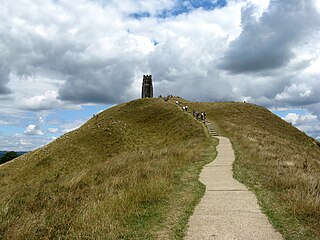
| 11 September 1275 | South Wales to Southern England | | | >VII | ~6.0 | In Glastonbury, the Abbey was damaged and the Church of St. Michael on the Torr Hill destroyed. "Only contemporary report of earthquake fatalities before 1580". See 1275 British earthquake | [2] [4] |
| 21 May 1382 | Strait of Dover, England | 51.34 | 2.00 | VII–VIII | >5.5 | The bell tower of the cathedral was "severely damaged" and the six bells "shook down". Cloister walls to the Canterbury dormitory were ruined. In Kent, All Saints Church, West Stourmouth, was badly damaged. Felt in London (MMVI) and lent its name to the "Earthquake Synod". See 1382 Dover Straits earthquake | [2] |
| 28 December 1480 | Norwich, England | | | VIII | | Severe damage reported affecting a wide area | [2] [5] |
| 6 April 1580 | Strait of Dover, England | 51.06 | 1.60 | VII–VIII | 5.8~5.8 | See Dover Straits earthquake of 1580 | [2] |
| 11 April 1650 | Cumberland, England | 54.98 | −2.78 | VII | 4.9 | Epicentre probably near Carlisle, felt at Glasgow | [2] [5] |
| 18 September 1692 | Duchy of Brabant, Belgium | 50.8 | 4.8 | | 6.0~6.0 | Felt in most parts of England, France, Germany and the Netherlands | [6] [7] |
| 19 July 1727 | Swansea, Wales | 51.57 | -3.76 | VII | 3.3 | Rang church bells as far away as Oxford. | [2] [5] |
| 8 September 1775 | Swansea, Wales | 51.73 | −3.81 | VII | 5.1 | Some buildings said to have collapsed, felt from Devon to Lancashire to Surrey | [2] [5] |
| 7 September 1801 | Comrie, Perth and Kinross, Scotland | 56.4 | −3.99 | VI | 4.6 | Two farmworkers were killed when part of a barn collapsed | [2] [5] |
| 17 March 1816 | Mansfield, England | 53.09 | −1.18 | VII | 4.2 | Falling masonry injured several in the church at Mansfield, felt from Blackburn to Hull to Gumley | [2] [5] |
| 27 August 1834 | Chichester, England | 50.82 | −0.82 | VII | 3.3 | Last in a sequence of damaging earthquakes starting with an event in September 1833 that caused the death of a quarryman | [2] [5] |
| 23 October 1839 | Comrie, Perth and Kinross, Scotland | | | VII | 4.8~4.8 | Part of a long-lived earthquake swarm. This was the largest of all known Comrie earthquakes, and was felt over most of Scotland. It caused a dam near Stirling to breach. | [2] [5] |
| 9 November 1852 | Caernarfon, Wales | 53.02 | −4.30 | VII | 5.3 | Similar to the 1984 Llŷn Peninsula earthquake, felt in Dublin, Belfast, Carlisle and Cheltenham | [2] [5] |
| 15 February 1865 | Barrow in Furness, England | 54.07 | −3.18 | VIII | 2.2 | Small area of high intensity indicating a shallow focus (≤1 km) | [2] [5] |
| 28 November 1880 | Argyll, Argyll and Bute, Scotland | 56.19 | −5.30 | VI | 5.2~5.2 | Largest recorded earthquake in Scotland. | [2] [5] |
| 22 April 1884 | Colchester, Essex, England | 51.82 | 0.90 | VIII | 4.6~4.6 | The most damaging earthquake since 1580. At least two indirect fatalities reported. Felt in France and Belgium. See 1884 Colchester earthquake. | [2] |
| 18 August 1892 | Pembroke, Wales | 51.70 | −5.04 | VII | 5.1 | Felt most strongly in Wales and South West England, but also felt in SE Ireland | [2] [5] |
| 17 December 1896 | Hereford, England | 52.02 | −2.55 | VII | | Felt widely throughout England and Wales and E Ireland | [2] [5] |
| 18 September 1901 | Inverness, Scotland | 57.43 | −4.32 | VII | 5.0 | Considerable minor damage, many falling chimney pots. Many foreshocks and aftershocks. | [2] [5] |
| 24 March 1903 | Derby, England | 53.05 | −1.70 | VII | 4.6 | Felt from Hoylake, to Boston and Richmond to Barnt Green | [2] [5] |
| 27 June 1906 | Swansea, Wales | 51.62 | −3.81 | VII | 5.2 | One of the most damaging British earthquakes of the 20th century. See 1906 Swansea earthquake. | [2] [8] |
| 14 January 1916 | Stafford, England | 52.85 | −2.19 | VII | 4.6 | Significant damage at Chebsey | [2] [5] |
| 4 April 1924 | Mansfield, England | 53.11 | −1.34 | VII | | Most damaging of a sequence that started on 3 March | [2] [5] |
| 15 August 1926 | Ludlow, England | 52.31 | −2.66 | VII | 4.8 | Felt from Plymouth to Hull | [2] [5] |
| 3 May 1931 | Manchester, England | 53.50 | −2.35 | VII | 3.7 | Small but damaging earthquake | [2] [5] |
| 7 June 1931 | Dogger Bank, North Sea | 54.08 | 1.50 | VII | 6.1 | Strongest recorded instrumentally. See 1931 Dogger Bank earthquake. | [2] [5] |
| 16 July 1940 | Kilsyth, Scotland | 56.00 | −4.00 | VII–VIII | 3.7 | House gable collapsed at Carronbridge | [2] [5] |
| 12 December 1940 | Caernarfon, Wales | 53.03 | −4.18 | V | 4.7 | An elderly woman was killed after she fell down the stairs | [2] [5] |
| 30 December 1944 | Skipton, England | 53.86 | −2.02 | VII | 4.8 | Generally minor damage | [2] [5] |
| 11 February 1957 | Derby, England | 52.80 | −1.33 | VII | 5.3 | Felt across central England. Largest UK post-war earthquake until 1984, and one of the most damaging earthquakes of the twentieth century. | [2] [5] |
| 26 December 1979 | Longtown, Cumbria, England | 55.03 | −2.82 | VI | 4.7 | Damage to buildings in Canonbie, Carlisle, and Glasgow. | [2] [5] |
| 19 July 1984 | Llŷn Peninsula, Gwynedd, Wales | 52.96 | −4.38 | VII | 5.4 | Felt across Ireland and western Great Britain. See 1984 Llŷn Peninsula earthquake. | [2] [5] |
| 2 April 1990 | Bishop's Castle, England | 52.43 | −3.03 | VI | 5.1 | Very widely felt in Wales and England. See 1990 Bishop's Castle earthquake. | [2] |
| 22 September 2002 | Dudley, West Midlands, England | 52.53 | −2.16 | V | 4.7 | Widely felt in England and Wales. | [9] |
| 21 October 2002 | Manchester, England | | | | 3.9 | Largest in an earthquake swarm of 116 earthquakes, 36 of which were felt | [2] |
| 28 April 2007 | Folkestone, Kent | 51.10 | 1.17 | VI | 4.3 | Caused significant damage in Folkestone, felt throughout Kent. See 2007 Kent earthquake. | [10] |
| 27 February 2008 | Market Rasen, Lincolnshire, England | 53.400 | −0.332 | VI | 5.2 | Felt widely in England and Wales. See 2008 Market Rasen earthquake. | [11] |
| 1 April 2011 | Blackpool, England | | | | 2.3 | First of two minor earthquakes that were caused by fracking carried out by Cuadrilla | [12] |
| Note: The inclusion criteria for adding events are based on WikiProject Earthquakes' notability essay that was developed for stand alone articles. The principles described also apply to lists. In summary, only damaging, injurious, or deadly events should be recorded. |