
This list of earthquakes in Greece includes notable earthquakes that have affected Greece during recorded history. This list is currently incomplete, representing only a fraction of the possible events.
This list of earthquakes in Greece includes notable earthquakes that have affected Greece during recorded history. This list is currently incomplete, representing only a fraction of the possible events.
Greece is located at the complex boundary zone in the eastern Mediterranean between the African Plate and the Eurasian Plate. The northern part of Greece lies on the Eurasian Plate while the southern part lies on the Aegean Sea Plate. The Aegean Sea Plate is moving southwestward with respect to the Eurasian Plate at about 30 mm/yr while the African Plate is subducting northwards beneath the Aegean Sea Plate at a rate of about 40 mm/yr. The northern plate boundary is a relatively diffuse divergent boundary while the southern convergent boundary forms the Hellenic arc. [1]
These two plate boundaries give rise to two contrasting tectonic styles, extension on east–west trending fault zones with strike-slip tectonics on SW-NE trending fault zones throughout west and central Greece, Peloponnese and the northern Aegean and contractional in the southern Aegean, continuing around to the Ionian islands. The south Aegean is the location of the volcanic arc and is characterised by extension. To the east of Crete along the Hellenic Arc, strike-slip tectonics with some extension become important. [1]
The strongest earthquakes historically are those associated with the Hellenic Arc, although none larger than about 7.2 have been observed instrumentally. The events of AD 365 and 1303 are likely to have been much larger than this. In mainland Greece, normal faulting gives earthquakes up to 7 in magnitude, while in the northern Aegean, strike-slip events with a magnitude of 7.2 have been recorded. Large intermediate depth (>50 km) earthquakes of magnitude >7 from within the subducting African Plate have been recorded but such events cause little damage, although they are widely felt. [1]
| Date | Place | Lat | Lon | Deaths | Mag. | MMI | Comments | Sources |
|---|---|---|---|---|---|---|---|---|
| 2022-01-09 | Florina, Western Macedonia | 40.842 | 21.376 | 5.5 Mw | VII | Several houses and buildings were damaged in Florina, while one uninhabited house collapsed in the village of Agia Paraskevi. Two people were hospitalized. [2] [3] | USGS [4] | |
| 2021-10-12 | Lasithi | 35.193 | 26.256 | 6.4 Mw | VIII | A chapel was destroyed following the earthquake in the village of Xerokampos. [5] | USGS [6] | |
| 2021-09-27 | Crete | 35.252 | 25.260 | 1 | 6.0 Mw | VIII | USGS [7] | |
| 2021-03-03 | Larissa | 39.755 | 22.176 | 1 | 6.3 Mw | VIII | 1 death [8] 3 injures | USGS [9] |
| 2020-12-02 | Thiva | 38.33 | 23.4644 | 5.1 Mw | VI | A cemetery was completely destroyed in the village of Kallithea, while in the same village a displacement of 6 cm was observed. | [10] [11] | |
| 2020-10-30 | Near Samos, Aegean Sea | 37.897 | 26.795 | 119 | 7.0 Mw | X | Greece:19 people injured and 2 teenagers (15 and 17) killed. Turkey:The earthquake injured an addition 1,034 and killed 114 people in the coastal city İzmir, Turkey. [12] [13] | USGS [14] |
| 2020-03-21 | Parga, Epirus | 39.357 | 20.638 | 5,7Mw | VII | The earthquake was particularly felt in Thesprotia and Preveza where people took to the streets, It was also felt in Ioannina, Arta, Corfu and in general in the wider area, the earthquake caused serious damage in Kanalaki. [15] (2 injures) | USGS [16] | |
| 2019-11-27 | Aegean Sea, offshore Antikythera | 35.63 | 23.21 | 6.1 Mw | VI | Depth of focus reached 56 km, making it perceived from more than 300 km away. Some damage. [17] | CNN [18] | |
| 2019-07-19 | Athens | 38.095 | 23.525 | 5.3 Mw | VII | 7 injured and material damage to buildings, the epicenter of the earthquake was 23 km northwest of Athens and the focal depth was 10 km [19] | USGS [20] | |
| 2019-03-30 | Galaxidi | 38.366 | 22.394 | 5.4 Mw | VII | Minor damage was observed inside the buildings, while in Patras poles came out of their house [21] | USGS [22] | |
| 2018-10-26 | Ionian Sea, offshore Zakynthos | 37.478 | 20.56 | 6.8 Mw | VI | Sea level changes were observed, prompting a local tsunami warning. | USGS [23] | |
| 2017-07-21 | Kos | 36.57 | 27.27 | 2 | 6.6 Mw | VII | 150 people injured in Greece, 370 injured in Turkey and two dead | BBC |
| 2017-06-12 | Lesbos | 38.93 | 26.37 | 1 | 6.3 Mw | IX | 10+ people injured, significant damage across parts of the island | |
| 2015-11-17 | Lefkada | 38.67 | 20.6 | 2 | 6.5 Mw | VIII | Four injured, A landslide in Egremni Beach two people dead. | [24] |
| 2014-05-24 | Limnos | 38.11 | 23.60 | 3 | 6.9 Mw | VIII | 3 deaths and 324 injuries reported in Greece, dozens of houses collapsed. | [25] |
| 2008-07-15 | Dodecanese | 35.93 | 27.81 | 1 | 6.4 Mw | VII | ||
| 2008-06-22 | Methoni, Messenia, Peloponnese | 36.00 | 21.90 | 6.0 Mw | VIII | There were four foreshocks before the main event / Earthquake swarm starting 14 February | [26] | |
| 2008-06-08 | Peloponnese | 37.96 | 21.53 | 2 | 6.4 Mw | VIII | 240 injured | |
| 2008-02-20 | Methoni, Messenia, Peloponnese | 37.96 | 21.53 | 6.1 Mw | V | Earthquake swarm | [27] | |
| 2008-02-14 | Methoni, Messenia, Peloponnese | 37.96 | 21.53 | 6.7 Mw & 6.6 Mw | V+ | Back to back seismic events in the span of two hours approximately / Minor damage / Earthquake swarm that continued throughout the year | [28] | |
| 2008-01-06 | Leonidio, Arcadia | 6.6 Mw | [29] | |||||
| 2006-01-08 | Kythira | 36.26 | 23.46 | 1 | 6.7-6.9 Mw | VII | Three injured | [30] |
| 2005-10-18 | Zakynthos | 6.0 Mw | No injuries or damage | [31] | ||||
| 2003-08-14 | Lefkada | 39 | 21 | 6.4 Mw | VIII | [32] | ||
| 2002-01-22 | Crete - Karpathos | 35.56 | 26.73 | 6.6 Mw | No injuries or damage | [33] | ||
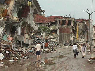
| 1999-09-07 | Athens | 38.06 | 23.51 | 143 | 6.0 Mw | IX | 1,600 injured / $3–4.2 billion in damage | |
| 1995-06-15 | Aigio | 38.40 | 22.28 | 26 | 6.4 Mw | VIII | 60 injuries / $660 million in damage | NGDC, [34] |
| 1995-05-13 | Kozani–Grevena | 40.15 | 21.70 | 6.6 Mw | VIII | 12-25 injured / $450 million in damage | NGDC, [35] | |
| 1990-12-21 | Goumenissa - Edessa | 40.92 | 22.36 | 1 | 6.1 Mw | VI | 1 killed in Edessa/ 60 injured | USGS [36] |
| 1990-06-16 | Preveza (regional unit) | 39.1 | 20.4 | 6.0 M | VI | 1 injured | [37] | |
| 1988-10-16 | Kyllini, Elis | 6.0 M | [38] | |||||
| 1986-09-13 | Kalamata | 37.01 | 22.18 | 20+ | 6.0 Mw | X | 300 injured / $5 million in damage | [39] |
| 1981-12-19 | Lesbos | 39.00 | 25.26 | 7.2 | VIII | 7 buildings collapsed | [40] | |
| 1981-02-24 | Athens - Eastern Gulf of Corinth, Halcyon Islands. | 38.22 | 22.93 | 20-22 | 6.7 Ms | IX | 500 injured / $812 million in damage / 22,554 buildings destroyed around Athens/ Local tsunami. 2 strong earthquakes followed (6.4 Ms and 6.3 Ms ) | [41] [42] |
| 1980-07-09 | Almyros, Magnesia (regional unit) | 39.27 | 22.83 | 6.5 | VIII | 24 injured / 5,222 buildings completely destroyed | [43] | |
| 1978-06-20 | Thessaloniki | 40.6 | 23.2 | 45–50 | 6.2 - 6.5 Mw | VIII | 100–220 injured | [44] |
| 1973-11-29 | Palaiochora, Crete | 35.18 | 23.75 | 6.0 Mw | VII+ | [45] | ||
| 1968-02-19 | Agios Efstratios, Aegean Sea | 39.37 | 25.96 | 20 | 7.1–7.2 Mw | X | 39 injuries / Local tsunami | NGDC, [46] |
| 1967-05-01 | Drosopighe, Arta (regional unit) | 39.47 | 21.25 | 9 | 6.4 | IX | 56 injured | [47] |
| 1966-10-29 | Katouna, Aetolia-Acarnania | 38.78 | 21.11 | 1 | 6.0 | VIII | 43 injured | [48] |
| 1966-09-01 | Megalopolis, Greece, Arcadia | 37.39 | 22.14 | 6.0 | VIII | 24 injured | [49] | |
| 1966-02-05 | Kremasta (lake), Evrytania | 39.05 | 21.75 | 1 | 6.2 | IX | 65 injured / 731 buildings collapsed | [50] |
| 1965-07-06 | Erateini, Phocis | 38.27 | 22.30 | 1 | 6.3 | VIII | 6 injured / 575 buildings collapsed | [51] |
| 1965-04-09 | Kandanos, Crete | 35.13 | 24.31 | 6.1 | VI+ | [52] | ||
| 1965-04-05 | Apiditsa, Arcadia | 37.40 | 22.10 | 18 | 6.1 | VIII | 17 injured / 1,426 buildings collapsed | [53] |
| 1965-03-09 | Alonnisos | 39.16 | 23.89 | 2 | 6.1 | IX | 2 injured / 1941 buildings collapsed | [54] |
| 1959-05-14 | Pitsidia, Crete | 35.00 | 24.72 | 6.3 | VIII+ | 8 injured | [55] | |
| 1957-04-25 | Rhodes | 36.50 | 28.60 | 7.2 | VIII | In Turkish coast there were 18 fatalities and 3,000 buildings destroyed | [56] | |
| 1956-07-09 | Amorgos | 36.67 | 25.957 | 53 | 7.5 Mw | IX | Triggered a tsunami that affected the entire Aegean Sea / 100 injuries | [57] |
| 1955-07-16 | Samos - Agathonisi | 37.55 | 27.05 | 6.9 | VIII | 2 injured | [58] | |
| 1955-04-19 | Lechonia, Magnesia (regional unit) | 39.37 | 23.00 | 1 | 6.2 | VIII | 41 injured | [59] |
| 1954-04-30 | Sofades, Karditsa (regional unit) | 39.28 | 22.29 | 25-31 | 6.7-7.0 Mw | IX | 6,559 buildings destroyed | [60] [61] |
| 1953-10-21 | Kandila, Aetolia-Acarnania | 38.60 | 20.96 | 6.3 | VIII | [62] | ||
| 1953-08-09 | Cephalonia, Zakynthos | 38.18 | 20.94 | 445–800 | 6.4 Mw, 6.8 Mw & 7.2 Mw | X | Two foreshocks and one major earthquake occurred in the span of three days / 2,412 injured / The islands of Cephalonia, Zakynthos and Ithaca were leveled. From the 33,300 buildings of these three islands, 27,659 were completely destroyed | [63] |
| 1947-10-06 | Messenia, Peloponnese | 36.96 | 21.68 | 3 | 7.0 | IX | 20 injured | [64] |
| 1941-03-01 | Larissa, Thessaly | 39.67 | 22.54 | 40 | 6.3 | VIII | 100 injured / In Larissa, 10% of the city's buildings have been completely destroyed and 60% seriously damaged | [65] |
| 1938-07-20 | Oropos, East Attica | 38.29 | 23.79 | 18 | 6.0 | VIII | 107 injured / 8,000 homeless | [66] |
| 1933-04-23 | Kos | 36.8 | 27.3 | 74-200 | 6.6 | IX–X | 600 injuries | [67] [68] |
| 1932-09-26 | Ierissos | 39.8 | 23.8 | 161-491 | 7.0 Ms | X | Tsunami / 669 injuries / 4,106 buildings destroyed | [69] |
| 1928-04-22 | Corinth | 38 | 23 | 20 | 6.0 Ms | IX | 3,000 homes destroyed / tsunami | NGDC |
| 1917-12-24 | Nafpaktos | 38.40 | 21.70 | 6.0 | VIII | [70] | ||
| 1914-11-27 | Lefkada | 38.72 | 20.62 | 16 | 6.3 | IX | Small tsunami | , [71] [72] |
| 1904-08-11 | Samos | 37.66 | 26.93 | 4 | 6.8 | VIII | 7 injuries / 540 buildings destroyed | [73] |
| 1902-08-11 | Assiros, Thessaloniki (regional unit) | 5 | 6.6 Mw | IX | [74] | |||
| 1895-05-14 | Paramythia, Thesprotia | 75 | 6.3 Mw | 46 injuries | [75] | |||
| 1894-04-27 | Atalanti | 38.65 | 23.08 | 255 | 6.7 Mw & 7.0 Mw | XI | Two earthquakes, 7 days apart / 3,783 buildings destroyed | [76] |
| 1893-05-23 | Thebes | 38.31 | 23.25 | 2 | 6.2 | VIII | [77] | |
| 1893-04-17 | Zakynthos | 6.4 | IX | From 4,500 buildings of the island, 2,000 were completely destroyed | [78] | |||
| 1889-10-13/14 | Lesbos | 36 | 6.7 | 200 injuries | [79] | |||
| 1893-02-09 | Samothrace | 40.59 | 25.53 | 1 | 6.8 | IX | 10-20 injuries | [80] |
| 1886-08-27 | Filiatra | 37.10 | 21.50 | 326-600 | 7.5 | X | 796 injuries / 6,000 buildings collapsed or severely damaged / 123 villages destroyed/ Tsunami | NGDC, [81] |
| 1881-04-03 | Chios, Çeşme, Alaçatı | 38.30 | 26.20 | 3,550 | 6.5-7.3 | XI | 7,000 injured | [82] |
| 1870-08-01 | Arachova | 38.48 | 22.55 | 117 | 6.8 | VIII | 380 injured / 2,000 buildings destroyed | [83] |
| 1869-12-16 | Lefkada | 15 | 6.4 | Only 20-25 houses were saved | [84] | |||
| 1867-03-07 | Lesbos | 39.2 | 26.4 | 550 | 6.8-7.0 | X | 816 injured / 10,275 buildings were damaged | NGDC, [85] |
| 1867-02-04 | Lixouri, Cephalonia | 38.4 | 20.2 | 200-224 | 7.2 | X | 2,612 buildings collapsed | NGDC, [86] |
| 1866-01-31 | Santorini | 6.1 | VIII | The volcano of Nea Kameni erupted and began creating two islets | [87] | |||
| 1865-07-23 | Lesbos | 10 | 6.7 | IX | , [88] [79] | |||
| 1861-12-26 | Valimitika, Achaea | 38.25 | 22.16 | 20 | 6.7 | IX | Tsunami wave at the Gulf of Corinth | [89] |
| 1858-02-09 | Corinth | 21 | 6.7 | 65 injuries | [90] | |||
| 1856-10-12 | Rhodes, Crete | 35.5 | 26 | 538 | 8.2 | XI | 638 injuries / 16,512 homes destroyed / tsunami | NGDC, [91] |
| 1853-08-18 | Thebes, Greece | 13 | 6.8 | Destroyed most of the buildings of city of Thebes | NGDC, [92] | |||
| 1846-06-11 | Messini, Messenia | 30 | 6.5 | 2,500 buildings destroyed | NGDC, [93] [94] | |||
| 1840-10-30 | Zakynthos | 38 | 21 | 12 | X | NGDC | ||
| 1837-03-20 | Hydra (island), Saronic Gulf | 1 | 6.2 Mw | VII | [95] | |||
| 1829-05-05 | Xanthi, Western Thrace | 41.1 | 24.5 | 7.3 Mw | IX | The city of Xanthi was almost destroyed. Drama (X) was almost completely destroyed, as well as many villages in the municipal county. | [96] | |
| 1825-01-19 | Lefkada | 6.5 Mw | X | [97] | ||||
| 1817-08-23 | Helike | 6.6 Mw | ||||||
| 1810-02-16 | Crete, Heraklion | 35.5 | 25.6 | 2,000 | 7.5 Mw | X | ||
| 1804-06-08 | Patras | 38.1 | 21.7 | 10 | 6.4 Mw | IX | [98] [99] | |
| 1752-07-29 | East Thrace | 41.41 | 26.61 | >100 | 7.5 Mw | VIII | The cities of Havsa (IX) and Haskoy were leveled while Andrianoupolis (Edirne) and other cities of East Thrace suffered great damage. | [100] [101] |
| 1630-03-09 | Crete | |||||||
| 1481-05-03 | Rhodes | 36.0 | 28.0 | 30,000 | 7.1 Ms | X | Tsunami | |
| 1303-08-08 | Crete, Alexandria | 35.0 | 27.0 | Many thousands | ~8 | IX | Triggered a major tsunami; severely damaged the Lighthouse of Alexandria | |
| Dec 856 | Corinth | 37.9 | 22.9 | 45,000 | [102] | |||
| 515 | Rhodes | Ambraseys states that the death toll in this nighttime event was high and that the damage was severe | [103] | |||||
| 365-07-21 | Crete, Alexandria | 35.0 | 23.0 | Many thousands | 8.5+ | Raised part of Crete 9 metres, causing severe damage and triggering a tsunami that devastated Alexandria | ||
| 226 BC | Rhodes | 36.43 | 28.21 | Toppled the Colossus of Rhodes | ||||
| 426 BC | Skarfeia, Euboic Gulf | 38.85 | 22.78 | 2,550 | 7.0 | IX | The historian Thucydides concluded that the Malian Gulf tsunami of the same year was caused by the earthquake, the first to recognize such a link | [104] [105] |
| 464 BC | Sparta | 37.08 | 22.43 | ~20,000 | 7.2 Ms |

Heraklion or Herakleion, sometimes Iraklion, is the largest city and the administrative capital of the island of Crete and capital of Heraklion regional unit. It is the fourth largest city in Greece with a municipal population of 177,064 and 211,370 in its wider metropolitan area, according to the 2011 census.

The Aegean dispute is a set of interrelated controversies between Greece and Turkey over sovereignty and related rights in the region of the Aegean Sea. This set of conflicts has strongly affected Greek-Turkish relations since the 1970s, and has twice led to crises coming close to the outbreak of military hostilities, in 1987 and in early 1996. The issues in the Aegean fall into several categories:
Greek–Turkish earthquake diplomacy is a phenomenon that has existed with notability since the summer of 1999, when Greece and Turkey were hit by successive earthquakes. It began with a generous Greek relief effort in Turkey following the İzmit earthquake on 17 August. Less than a month later, on 7 September, the Athens earthquake occurred and was met with a similarly generous Turkish relief effort in Greece. Prior to these mutual efforts, Greece–Turkey relations were generally marked by near-constant hostility stemming from the Istanbul pogrom of 1955. The magnanimous development of "earthquake diplomacy" between the two countries generated an outpouring of sympathy and assistance provided by ordinary Greeks and Turks in both cases; such acts were encouraged from the top and took many foreigners by surprise. They prepared the public for a breakthrough in bilateral ties, which had been marred by decades of diplomatic tension and, in the case of Cyprus, armed conflict.
The University of the Aegean is a public, multi-campus university located in Lesvos, Chios, Samos, Rhodes, Syros and Lemnos, Greece. It was founded on March 20, 1984, by the Presidential Act 83/1984 and its administrative headquarters are located in the town of Mytilene, on the island of Lesvos.

The Aegean Sea Plate is a small tectonic plate located in the eastern Mediterranean Sea under southern Greece and western Turkey. Its southern edge is the Hellenic subduction zone south of Crete, where the African Plate is being swept under the Aegean Sea Plate. Its northern margin is a divergent boundary with the Eurasian Plate.

The Hellenic Trench (HT) is an oceanic trough located in the forearc of the Hellenic Arc, an arcuate archipelago on the southern margin of the Aegean Sea Plate, or Aegean Plate, also called Aegea, the basement of the Aegean Sea. The HT begins in the Ionian Sea near the mouth of the Gulf of Corinth and curves to the south, following the margin of the Aegean Sea. It passes close to the south shore of Crete and ends near the island of Rhodes just offshore Anatolia.
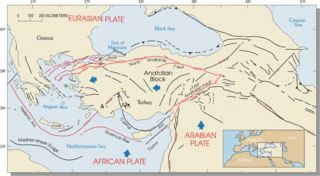
The Hellenic arc or Aegean arc is an arcuate mountain chain of the southern Aegean Sea located on the southern margin of the Aegean Sea Plate. Geologically it results from the subduction of the African Plate under it along the Hellenic subduction zone. The Hellenic Trench trends parallel to its southern side. The Aegean Sea Plate, a microplate, is often considered part of the Eurasian Plate from which it is in the process of diverging. The arc itself is mainly marine, the mountaintops appearing as islands in the Ionian Sea, Crete and its environs, or in the Dodecanese group. It encroaches on mainland terrain in the Peloponnesus, on Crete, on Rhodes, and on the southern coast of Anatolia, thus being encompassed by both Greece and Turkey.
The 1932 Ierissos earthquake occurred at 19:20 on 26 September. It caused severe damage in Ierissos, Greece and the surrounding part of the Chalkidiki peninsula, with 161–491 casualties reported.
The 1978 Thessaloniki earthquake occurred on 20 June at 23:03 local time. The shock registered 6.5 on the moment magnitude scale, had a maximum Mercalli intensity of VIII (Severe), and was felt throughout northern Greece, Yugoslavia and Bulgaria. It was the largest event in the area since the 1932 Ierissos earthquake.

Neapoli Voion or Neapolis Voion also named Vatika is a small town in Laconia regional unit, southern Greece. It is built near the south end of Malea peninsula, close to the Cape Maleas. It is 335 km southeast of Athens and 115 km south of Sparta. Its port is the gateway for the island of south Peloponnese such as Kythera, Antikythera and Elafonisos. Neapoli is the part of Monemvasia municipality and Voies municipal unit. Its population is 3090 residents according to 2011 census.

An earthquake with a moment magnitude of 7.0 occurred on 30 October 2020 about 14 km (8.7 mi) northeast of the Greek island of Samos. Although Samos was closest to the epicentre, it was the Turkish city İzmir, 70 km (43 mi) northeast that was heavily affected—more than 700 residential and commercial structures were seriously damaged or destroyed. One hundred and seventeen people died in İzmir Province while an additional 1,034 were injured. In Greece, there were two fatalities and 19 injured. The earthquake is the deadliest in the year 2020, and the third major earthquake to strike Turkey that year. The event is called the Samos earthquake by the International Seismological Centre.
The 1856 Heraklion earthquake, also known as the Crete earthquake or Rhodes earthquake, occurred on the morning of October 12 at 02:45 am local time. This extremely catastrophic earthquake had an estimated magnitude of 7.7 to 8.3 at a depth of approximately 61 to 100 km. The earthquake was felt over a very wide area extending from Sicily, Italy to the Levant and North Africa. On the Greek island of Crete, the effects of the earthquake were cataclysmic, over 500 bodies were recovered in the city of Heraklion. Shockwaves from the earthquake were felt intensely, covering all of the Ottoman Empire; present-day Turkey, Cyprus and the Middle East where damage and human losses were reported. In Malta, the earthquake collapsed the Għajn Ħadid Tower—a coastal watchtower built around the year 1638. In Cairo, Egypt, the earthquake destroyed buildings, created seiches in canals, and killed several people. Off the Egyptian and Italian coasts, sailors reported feeling a seaquake.
The 1986 Kalamata earthquake struck the southern Peloponnese Region of Greece on September 13 at 20:24 local time. The 12.5 km (7.8 mi) deep moment magnitude (Mw ) 5.9 earthquake had an epicenter near the coastal city of Kalamata and was assigned X (Extreme) on the Mercalli intensity scale. The earthquake was the result of normal faulting along a northwest-dipping fault and produced surface ruptures. Extensive damage was reported in Kalamata and Elaiochori. At least 20 people died and 330 were injured. Survivors sought refuge at campsites and reconstruction work lasted five years.

On March 3, 2021, 12:16:09 the 2021 Larissa earthquake had a magnitude of 6.3 Mw with an intensity of VIII (Severe) on the Mercalli Scale 9 kilometers west of Týrnavos, Greece. One person was confirmed dead with eleven other people injured. Light shaking was also felt as far as Albania, North Macedonia, Kosovo and Montenegro.
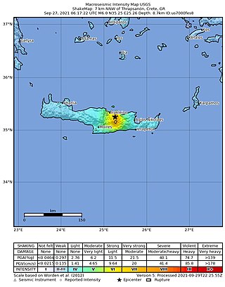
A moment magnitude 6.0 earthquake struck the island of Crete in Greece at a depth of 6 km on 27 September 2021. The epicenter of the earthquake was located southeast of Heraklion. The quake killed one person, injured 36 and damaged over 5,000 old buildings on the island.
The 2021 Lasithi earthquake was a magnitude 6.4 Mw earthquake with a maximum intensity of VIII (Severe) on the Modified Mercalli Intensity Scale which occurred on October 12, 2021, 12:24 (UTC+3:30) off the island of Crete. The quake was also felt at low intensity as far as Cairo and Istanbul.

Storm Ballos was a notable extratropical cyclone that caused devastating floods across Greece during mid-October 2021. The second storm to be officially named in conjunction with the naming list of the former, Israel and Cyprus, Ballos formed on 13 October over the Mediterranean Sea from the combination of a frontal system and a circulation which first developed, two days earlier. It then moved over Greece, before proceeding into the Aegean Sea, where it slowly weakened and dissipated by 16 October. However, despite the HNMC naming the system, the Free University of Berlin (FUB) didn’t assign any name on it along with its weather maps.

The southern margin of the Gulf of Corinth was struck by a major earthquake on 26 December 1861 at 08:28 a.m. local time. It had an estimated magnitude in the range 6.6–6.7 Mw and a maximum felt intensity of IX (destructive) on the European macroseismic scale (EMS). It caused widespread damage on both sides of the Gulf and led to up to 20 deaths and a further 126 people being injured, 18 of them seriously. A series of tsunami waves were reported, with a maximum run-up of 2.1 m.
{{cite journal}}: Cite journal requires |journal= (help){{cite web}}: CS1 maint: multiple names: authors list (link) CS1 maint: numeric names: authors list (link)Sources
| Authority control databases: National |
|---|