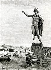
The Colossus of Rhodes was a statue of the Greek sun-god Helios, erected in the city of Rhodes, on the Greek island of the same name, by Chares of Lindos in 280 BC. One of the Seven Wonders of the Ancient World, it was constructed to celebrate the successful defence of Rhodes city against an attack by Demetrius I of Macedon, who had besieged it for a year with a large army and navy.
The 365 Crete earthquake occurred at about sunrise on 21 July 365 in the Eastern Mediterranean, with an assumed epicentre near Crete. Geologists today estimate the undersea earthquake to have been a moment magnitude 8.5 or higher. It caused widespread destruction in the central and southern Diocese of Macedonia, Africa Proconsularis, Egypt, Cyprus, Sicily, and Hispania (Spain). On Crete, nearly all towns were destroyed.
The 1855 Wairarapa earthquake occurred on 23 January at about 9.17 p.m., affecting much of the Cook Strait area of New Zealand, including Marlborough in the South Island and Wellington and the Wairarapa in the North Island. In Wellington, close to the epicentre, shaking lasted for at least 50 seconds. The moment magnitude of the earthquake has been estimated as 8.2, the most powerful recorded in New Zealand since systematic European colonisation began in 1840. This earthquake was associated with the largest directly observed movement on a strike-slip fault, maximum 18 metres (59 ft). This was later revised upward to about 20 m (66 ft) slip, with a local peak of 8 m (26 ft) vertical displacement on lidar studies. It has been suggested that the surface rupture formed by this event helped influence Charles Lyell to link earthquakes with rapid movement on faults.
The 1692 Jamaica earthquake struck Port Royal, Jamaica, on 7 June. A stopped pocket watch found in the harbor during a 1959 excavation indicated that it occurred around 11:43 AM local time.
The 1481 Rhodes earthquake occurred at 3:00 in the morning on 3 May. It triggered a small tsunami, which caused local flooding. There were an estimated 30,000 casualties. It was the largest of a series of earthquakes that affected Rhodes, starting on 15 March 1481, continuing until January 1482.

The Hellenic Trench (HT) is an oceanic trough located in the forearc of the Hellenic Arc, an arcuate archipelago on the southern margin of the Aegean Sea Plate, or Aegean Plate, also called Aegea, the basement of the Aegean Sea. The HT begins in the Ionian Sea near the mouth of the Gulf of Corinth and curves to the south, following the margin of the Aegean Sea. It passes close to the south shore of Crete and ends near the island of Rhodes just offshore Anatolia.
The 1303 Crete earthquake occurred at about dawn on 8 August. It had an estimated magnitude of about 8, a maximum intensity of IX (Violent) on the Mercalli intensity scale, and triggered a major tsunami that caused severe damage and loss of life on Crete and at Alexandria. It badly damaged the Lighthouse of Alexandria.
The 141 Lycia earthquake occurred in the period AD 141 to 142. It affected most of the Roman provinces of Lycia and Caria and the islands of Rhodes, Kos, Simi and Serifos. It triggered a severe tsunami which caused major inundation. The epicenter for this earthquake is not well constrained, with locations suggested at the northern end of Rhodes, on the Turkish mainland north of Rhodes near Marmaris and beneath the sea to the east of Rhodes.
The 1956 Amorgos earthquake occurred at 03:11 UTC on July 9. It had a magnitude of 7.7 on the moment magnitude scale and a maximum perceived intensity of IX on the Mercalli intensity scale. The epicentre was to the south of the island of Amorgos, the easternmost island of the Cyclades in the Aegean Sea. There was significant damage on Amorgos and the neighbouring island of Santorini. It was the largest earthquake in Greece in the 20th century. It was followed 13 minutes later by a magnitude 7.2 earthquake near Santorini. It triggered a major tsunami with a maximum run-up of 30 m. The combined effects of the earthquake shaking and the tsunami caused the deaths of 53 people with a further 100 injured.
Archaeoseismology is the study of past earthquakes deriving from the analysis of archaeological sites. Such analyses reveal information about seismic events that have not been historically recorded. Such data can also help to document seismic risk in areas subject to extremely destructive earthquakes. In 1991, an international conference held in Athens marked the beginning of modern research in the field of archaeoseismology, described as a "study of ancient earthquakes, and their social, cultural, historical and natural effects".

The 262 Southwest Anatolia earthquake devastated the Roman city of Ephesus along with cities along the west and south coasts of Anatolia in year 262, or possibly 261, on 21 December. The epicenter was likely located in the southern Aegean Sea. Reports note that many cities were flooded by the sea, presumably due to a tsunami.

In 21 July 2017, a large earthquake measuring 6.6 on the moment magnitude scale struck right near Bodrum, a popular town of tourism in Turkey, killing 2 and injuring hundreds. Mostly referenced as the 2017 Bodrum–Kos earthquake, this earthquake generated a tsunami which was one of the largest tsunamis in the Mediterranean Sea region.

An earthquake with a moment magnitude of 7.0 occurred on 30 October 2020 about 14 km (8.7 mi) northeast of the Greek island of Samos. Although Samos was closest to the epicentre, it was the Turkish city İzmir, 70 km (43 mi) northeast that was heavily affected—more than 700 residential and commercial structures were seriously damaged or destroyed. One hundred and seventeen people died in İzmir Province while an additional 1,034 were injured. In Greece, there were two fatalities and 19 injured. The earthquake is the deadliest in the year 2020, and the third major earthquake to strike Turkey that year. The event is called the Samos earthquake by the International Seismological Centre.
The 1856 Heraklion earthquake, also known as the Crete earthquake or Rhodes earthquake, occurred on the morning of October 12 at 02:45 am local time. This extremely catastrophic earthquake had an estimated magnitude of 7.7 to 8.3 at a depth of approximately 61 to 100 km. The earthquake was felt over a very wide area extending from Sicily, Italy to the Levant and North Africa. On the Greek island of Crete, the effects of the earthquake were cataclysmic, over 500 bodies were recovered in the city of Heraklion. Shockwaves from the earthquake were felt intensely, covering all of the Ottoman Empire; present-day Turkey, Cyprus and the Middle East where damage and human losses were reported. In Malta, the earthquake collapsed the Għajn Ħadid Tower—a coastal watchtower built around the year 1638. In Cairo, Egypt, the earthquake destroyed buildings, created seiches in canals, and killed several people. Off the Egyptian and Italian coasts, sailors reported feeling a seaquake.
The 1761 Lisbon earthquake and its subsequent tsunami occurred in the north Atlantic Ocean and south of the Iberian Peninsula. This violent shock which struck just after noon on 31 March 1761, was felt across many parts of Western Europe. Its direct effects were even observed far north in Scotland and Amsterdam, and to the south in the Canary Islands of Spain. The estimated surface-wave magnitude 8.5 event was the largest in the region, and the most significant earthquake in Europe since the Great Lisbon earthquake of 1755.

An earthquake occurred off the coast of the Alaska Peninsula on July 28, 2021, at 10:15 p.m. local time. The large megathrust earthquake had a moment magnitude of 8.2 according to the United States Geological Survey (USGS). A tsunami warning was issued by the National Oceanic and Atmospheric Administration (NOAA) but later cancelled. The mainshock was followed by a number of aftershocks, including three that were of magnitude 5.9, 6.1 and 6.9 respectively.
The 1843 Nias earthquake off the northern coast of Sumatra, Indonesia caused severe damage when it triggered a tsunami along the coastline. The earthquake with a moment magnitude (Mw ) of 7.8 lasted nine minutes, collapsing many homes in Sumatra and Nias. It was assigned a maximum modified Mercalli intensity of XI (Extreme).
The 1944 Gulf of Edremit–Ayvacik earthquake occurred on October 6 at 05:34:48 local time in Balıkesir Province, Turkey. It measured 6.7 on the moment magnitude scale (Mw ) and occurred at a depth of 15 km (9 mi). The normal-faulting event had a maximum MSK-64 intensity of IX. A total of 73 people died and 275 others were injured.
The 1979 Yapen earthquake occurred on September 12 at 05:17:51 UTC. It had an epicenter near the coast of Yapen Island in Irian Jaya, Indonesia. Measuring 7.5 on the moment magnitude scale and having a depth of 20 km (12 mi), it caused severe damage on the island. At least 115 were killed due to shaking and a moderate tsunami.
The 1968 Aegean Sea earthquake was a 7.0 earthquake that occurred in the early morning hours of February 20th, 1968 local time about 57.1 km (35.5 mi) away from Myrina, Greece. This earthquake occurred between mainland Greece and Turkey, meaning both countries were impacted. 20 people died, and 39 people were injured to various degrees. It was the deadliest Greek earthquake since the 1956 Amorgos earthquake.