The following is a list of ecoregions in Botswana, according to the Worldwide Fund for Nature (WWF).
A woodland is, in the broad sense, land covered with trees, or in a narrow sense, synonymous with wood, a low-density forest forming open habitats with plenty of sunlight and limited shade. Woodlands may support an understory of shrubs and herbaceous plants including grasses. Woodland may form a transition to shrubland under drier conditions or during early stages of primary or secondary succession. Higher-density areas of trees with a largely closed canopy that provides extensive and nearly continuous shade are often referred to as forests.

Sioma Ngwezi National Park is a 5,000-square-kilometre park in the south west corner of Zambia. It is undeveloped and rarely visited, lacking roads and being off the usual tourist tracks, but this may change in the future.
Baikiaea is a genus of flowering plants in the legume family, Fabaceae.
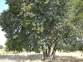
Baikiaea plurijuga, known as African teak, Mukusi, Rhodesian teak, Zambian teak or Zambesi redwood, is a species of Afrotropical tree from the legume family, the Fabaceae from southern Africa.

The Zambezian flooded grasslands is an ecoregion of southern and eastern Africa that is rich in wildlife.
The biomes and ecoregions in the ecology of Zambia are described, listed and mapped here, following the World Wildlife Fund's classification scheme for terrestrial ecoregions, and the WWF freshwater ecoregion classification for rivers, lakes and wetlands. Zambia is in the Zambezian region of the Afrotropical biogeographic realm. Three terrestrial biomes are well represented in the country . The distribution of the biomes and ecoregions is governed mainly by the physical environment, especially climate.

The Barotse Floodplain also known as the Bulozi Plain, Lyondo or the Zambezi Floodplain is one of Africa's great wetlands, on the Zambezi River in the Western Province of Zambia. It is a designated Ramsar site, regarded as being of high conservation value.

Angolan mopane woodlands are situated in southwestern Angola, extending into northern Namibia. This ecosystem surrounds Etosha Pan, which is considered a separate ecoregion. The mopane trees are the main type of vegetation.

The Kalahari Acacia-Baikiaea woodlands are an ecoregion located in Botswana, northern Namibia, South Africa and Zimbabwe.
The Zambezian dry evergreen forest, also known as the Zambezian Cryptosepalum dry forest, is a tropical dry broadleaf forest ecoregion of Southern Africa. It consists of several areas of thick forest in western Zambia and adjacent Angola. It is one of the largest areas of tropical evergreen forest outside the equatorial zone.

The Zambezian and mopane woodlands is a tropical and subtropical grasslands, savannas, and shrublands ecoregion of southeastern Africa.

The Western Zambezian grasslands is a tropical grassland ecoregion of eastern Zambia and adjacent parts of Angola. It is situated in two sections, to the north and south of the Barotse Floodplain. The region supports herds of ungulates, including Zambia's largest herd of Blue Wildebeast.

Zambezi National Park is a national park located upstream from Victoria Falls on the Zambezi River in Zimbabwe. It was split off from Victoria Falls National Park in 1979 and is 56,000 hectares in size. The park is bisected by a road to Kazungula, dividing it into a riverine side and a Chamabonda Vlei side. Most of the park is within the ecoregion of Zambezian and Mopane woodlands, while a small portion in the south is within the Zambezian Baikiaea woodlands.
The Zambezian region is a large biogeographical region in Africa. The Zambezian region includes woodlands, savannas, grasslands, and thickets, extending from east to west in a broad belt across the continent. The Zambezian region lies south of the rainforests of the Guineo-Congolian region. The Zambezian region is bounded by deserts and xeric shrublands on the southwest, the Highveld grasslands of South Africa to the south, and the subtropical Maputaland forests on the southeast.

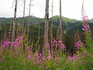
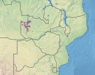
The Zambezian Baikiaea woodlands is an ecoregion in Africa. It includes dry deciduous forest and woodland, thicket, and grassland, dominated by the tree Baikiaea plurijuga. The ecoregion has a semi-arid climate, and is a transition between more humid miombo woodlands to the north, and the drier Kalahari Acacia-Baikiaea woodlands to the south.