Related Research Articles

The Arctic Archipelago, also known as the Canadian Arctic Archipelago, is an archipelago lying to the north of the Canadian continental mainland, excluding Greenland and Iceland.

Misiones is one of the 23 provinces of Argentina, located in the northeastern corner of the country in the Mesopotamia region. It is surrounded by Paraguay to the northwest, Brazil to the north, east and south, and Corrientes Province of Argentina to the southwest.
The extreme points of South America are the points that are farther north, south, east or west than any other location on the continent. The continent's southernmost point is often said to be Cape Horn, but Águila Islet of the Diego Ramírez Islands lies further south.
The Argentina Range is a range of rock peaks and bluffs, 42 nautical miles long, lying 35 nautical miles east of the northern part of Forrestal Range in the northeastern portion of the Pensacola Mountains of Antarctica.
This is a list of extreme points in Antarctica.
This is a list of the extreme points of The Americas, the points that are farther north, south, east or west than any other location on the continent. The continent's southernmost point is often said to be Cape Horn, which is the southernmost point of the Chilean islands. The Americas cross 134° of longitude east to west and 124° of latitude north to south.
Martin Peninsula is a peninsula about 60 nautical miles long and 20 nautical miles wide that is ice-covered except for a few rock outcrops along its margins, located between Getz Ice Shelf and Dotson Ice Shelf on the coast of Marie Byrd Land, Antarctica. The farthest point of the peninsula is Jacobsen Head.

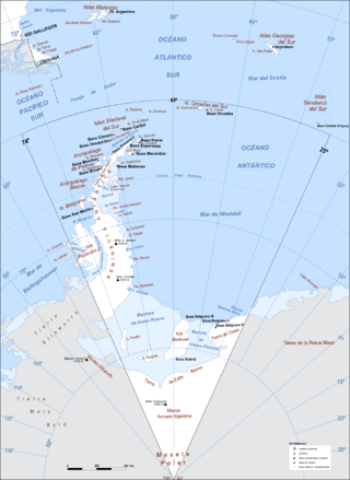
Argentine Antarctica is an area on Antarctica claimed by Argentina as part of its national territory. It consists of the Antarctic Peninsula and a triangular section extending to the South Pole, delimited by the 25° West and 74° West meridians and the 60° South parallel. This region overlaps with British and Chilean claims in Antarctica. None of these claims have widespread international recognition.

Bernardino Bilbao is a province in the Northern parts of the Bolivian department of Potosí. It has its name after Bernardino Bilbao Rioja, Bolivian general and politician.
Bernardo de Irigoyen is a city in the province of Misiones, Argentina. It has 10,889 inhabitants as per the 2001 census [INDEC], and is the head town of the General Manuel Belgrano Department. It carries the name of prominent politician and diplomat Bernardo de Irigoyen.
The Mariner Glacier is a major glacier over 60 nautical miles long, descending southeast from the plateau of Victoria Land, Antarctica, between Mountaineer Range and Malta Plateau, and terminating at Lady Newnes Bay, Ross Sea, where it forms the floating Mariner Glacier Tongue.

Bluie was the United States military code name for Greenland during World War II. It is remembered by the numbered sequence of base locations identified by the 1941 United States Coast Guard South Greenland Survey Expedition, and subsequently used in radio communications by airmen unfamiliar with pronunciation of the Greenlandic Inuit and Danish names of those locations. These were typically spoken BLUIE (direction) (number), with direction being east or west along the Greenland coast from Cape Farewell.

This is a list of the extreme points of Uruguay, the points that are farther north, south, east or west than any other location, and the highest and lowest points. It is also notable that Uruguay's northernmost point is farther south than the northernmost point of any other nation.

The Altiplano–Puna volcanic complex, also known as APVC, is a complex of volcanic systems in the Puna of the Andes. It is located in the Altiplano area, a highland bounded by the Bolivian Cordillera Real in the east and by the main chain of the Andes, the Western Cordillera, in the west. It results from the subduction of the Nazca Plate beneath the South American Plate. Melts caused by subduction have generated the volcanoes of the Andean Volcanic Belt including the APVC. The volcanic province is located between 21° S–24° S latitude. The APVC spans the countries of Argentina, Bolivia and Chile.