List of geological features on Europa

Last updated

This is a list of named geological features on Europa , a moon of the planet Jupiter. Craters and lineae are listed on separate pages: list of craters on Europa and list of lineae on Europa.

Contents

Cavi

Cavi are irregular steep-sided depressions that do not seem to be impact craters.

CavusPronouncedCoordinatesDiameter (km)Approval DateNamed AfterRefs
Moyle Cavus /ˈmɔɪl/ 25°S168°W / 25°S 168°W / -25; -168 1452019Moyle, a cold sea where the children of Lir (Llyr) spent three hundred years as swans WGPSN

Chaos

Enhanced color partial view of Conamara Chaos Europa Chaos.jpg
Enhanced color partial view of Conamara Chaos

On Europa, regions of chaotic terrain are named after places in Celtic mythology.

ChaosPronouncedCoordinatesDiameter (km)Approval DateNamed AfterRefs
Arran Chaos /ˈærən/ 13°24′N168°00′W / 13.4°N 168°W / 13.4; -168 262007 Isle of Arran, Scotland WGPSN
Conamara Chaos /kɒnəˈmɛərə/ 9°42′N272°42′W / 9.7°N 272.7°W / 9.7; -272.7 143.71997 Connemara, Ireland WGPSN
Murias Chaos 22°24′N83°48′W / 22.4°N 83.8°W / 22.4; -83.8 1162003 Murias WGPSN
Narberth Chaos 26°S273°W / 26°S 273°W / -26; -273 202007 Narberth, Wales WGPSN
Rathmore Chaos 25°24′N75°00′W / 25.4°N 75°W / 25.4; -75 572007 Rathmore, Ireland WGPSN

Flexūs

A flexus is a low, curved ridge with a scalloped pattern. Europan flexūs are named after the places visited by Europa during her journey with Zeus the bull.

FlexusPronouncedCoordinatesDiameter (km)Approval DateNamed AfterRefs
Cilicia Flexus /sɪˈlɪʃiə/ 59°30′S171°42′W / 59.5°S 171.7°W / -59.5; -171.7 13121979 Cilicia WGPSN
Delphi Flexus /ˈdɛlf/ 68°12′S174°06′W / 68.2°S 174.1°W / -68.2; -174.1 7931985 Delphi WGPSN
Gortyna Flexus /ɡɔːrˈtnə/ 42°06′S144°36′W / 42.1°S 144.6°W / -42.1; -144.6 9401979 Gortȳna WGPSN
Phocis Flexus /ˈfsɪs/ 44°30′S198°24′W / 44.5°S 198.4°W / -44.5; -198.4 2421985 Phocis WGPSN
Sidon Flexus /ˈsdən/ 66°24′S183°24′W / 66.4°S 183.4°W / -66.4; -183.4 11331979 Sidon WGPSN

Fossae

Fossae are named after ancient Celtic ancient stone rows.

FossaPronouncedCoordinatesDiameter (km)Approval DateNamed AfterRefs
Beenalaght Fossa 1°12′N82°05′W / 1.2°N 82.08°W / 1.2; -82.08 88228 May 2019 Beenalaght stone row, County Cork, Ireland WGPSN
Eightercua Fossa 6°41′N340°43′W / 6.68°N 340.71°W / 6.68; -340.71 40728 May 2019 Eightercua stone row, County Kerry, Ireland WGPSN
Kerlescan Fossae 3°20′N238°14′W / 3.34°N 238.24°W / 3.34; -238.24 41028 May 2019 Kerlescan stone row, Carnac, Brittany WGPSN
Kermario Fossae 44°41′N354°22′W / 44.69°N 354.36°W / 44.69; -354.36 19128 May 2019 Kermario stone row, Carnac, Brittany WGPSN
Maughanasilly Fossa 34°14′S155°11′W / 34.24°S 155.19°W / -34.24; -155.19 92028 May 2019 Maughanasilly stone row, County Cork, Ireland WGPSN
Ménec Fossae 51°59′S177°52′W / 51.98°S 177.87°W / -51.98; -177.87 3328 May 2019 Ménec stone row, Carnac, Brittany WGPSN

Large ringed features

Tyre multi-ring impact structure PIA01633 Tyre impact structure Europa.jpg
Tyre multi-ring impact structure

These impact structures are named after important locations in ancient history.

Large Ringed FeaturesPronouncedCoordinatesDiameter (km)Approval DateNamed AfterRefs
Callanish 16°42′S334°30′W / 16.7°S 334.5°W / -16.7; -334.5 1071997 Callanish, Scotland WGPSN
Tyre
(formerly listed as a macula)
/ˈtaɪər/ 33°36′N146°36′W / 33.6°N 146.6°W / 33.6; -146.6 1491997 Tyre, Lebanon WGPSN

Maculae

Europan maculae (dark spots) are named after locations in Greek mythology, especially in the legend of Cadmus and his search for his sister, Europa.

MaculaPronouncedCoordinatesDiameter (km)Approval DateNamed AfterRefs
Boeotia Macula /bˈʃiə/ 53°36′S166°48′W / 53.6°S 166.8°W / -53.6; -166.8 301997 Boeotia WGPSN
Castalia Macula /kəˈstliə/ 1°36′S225°42′W / 1.6°S 225.7°W / -1.6; -225.7 352003 Castalia WGPSN
Cyclades Macula /ˈsɪklədz/ 62°30′S191°18′W / 62.5°S 191.3°W / -62.5; -191.3 1071997 Cyclades WGPSN
Thera Macula /ˈθɪərə/ 46°42′S181°12′W / 46.7°S 181.2°W / -46.7; -181.2 951979 Thera WGPSN
Thrace Macula /ˈθrs/ 45°54′S172°06′W / 45.9°S 172.1°W / -45.9; -172.1 180.21979 Thrace WGPSN

Mensae

MensaCoordinatesDiameter (km)Approval DateNamed AfterRefs
Belenos Mensa 42°45′N75°05′W / 42.75°N 75.08°W / 42.75; -75.08 342019 Belenos, Italian Celtic sun god WGPSN
Borvo Mensa 0°27′S225°19′W / 0.45°S 225.31°W / -0.45; -225.31 49.722019 Borvo, Gallic god of healing WGPSN
Grannus Mensa 2°31′S225°48′W / 2.51°S 225.8°W / -2.51; -225.8 422019 Grannus, Romano-Celtic god of healing WGPSN

Regiones

Europan regiones (regions) are named after locations in Celtic mythology.

RegioPronouncedCoordinatesDiameter (km)Approval DateNamed AfterRefs
Annwn Regio /ˈænn/ 20°N320°W / 20°N 320°W / 20; -320 230011 May 2007 Annwn, Welsh otherworld WGPSN
Argadnel Regio 14°36′S208°30′W / 14.6°S 208.5°W / -14.6; -208.5 19002003 Argadnel, Celtic paradise WGPSN
Balgatan Regio 50°S30°W / 50°S 30°W / -50; -30 250011 May 2007 Balgatan Pass from Celtic mythology WGPSN
Dyfed Regio /ˈdʌvɪd/ 10°N250°W / 10°N 250°W / 10; -250 175011 May 2007 Kingdom of Dyfed WGPSN
Falga Regio 30°N210°W / 30°N 210°W / 30; -210 250011 May 2007 Inis Fer Falga, Irish legendary island WGPSN
Moytura Regio 50°00′S294°18′W / 50°S 294.3°W / -50; -294.3 4831997 Magh Tuiredh, Irish battle site WGPSN
Powys Regio /ˈpɪs/ 0°N145°W / 0°N 145°W / 0; -145 200011 May 2007 Kingdom of Powys WGPSN
Tara Regio /ˈtærə/ 10°S75°W / 10°S 75°W / -10; -75 178011 May 2007 Hill of Tara, Ireland WGPSN

Related Research Articles

<i>2010: Odyssey Two</i> 1982 science fiction novel by Arthur C. Clarke

2010: Odyssey Two is a 1982 science fiction novel by British writer Arthur C. Clarke. It is the sequel to his 1968 novel 2001: A Space Odyssey, though Clarke changed some elements of the story to align with the film version of 2001.

<span class="mw-page-title-main">Europa (moon)</span> Smallest Galilean moon of Jupiter

Europa, or Jupiter II, is the smallest of the four Galilean moons orbiting Jupiter, and the sixth-closest to the planet of all the 95 known moons of Jupiter. It is also the sixth-largest moon in the Solar System. Europa was discovered independently by Simon Marius and Galileo Galilei and was named after Europa, the Phoenician mother of King Minos of Crete and lover of Zeus.

<span class="mw-page-title-main">Pwyll (crater)</span> Crater on Europa

Pwyll is an impact crater on the surface of Jupiter's moon Europa. It is thought to be one of the youngest features on the moon. The crater was first observed from Voyager images in 1986, and the name was officially recognized by the IAU in 1997, after Pwyll of Welsh mythology.

<i>2061: Odyssey Three</i> 1987 novel by British writer Arthur C. Clarke

2061: Odyssey Three is a science-fiction novel by the British writer Arthur C. Clarke, published in 1987. It is the third book in Clarke's Space Odyssey series. It returns to one of the lead characters of the previous novels, Heywood Floyd, and his adventures from the 2061 return of Halley's Comet to Jupiter's moon Europa.

<span class="mw-page-title-main">Lineae</span> Long markings on a planet or moon

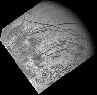
Linea is Latin for 'line'. In planetary geology it is used to refer to any long markings, dark or bright, on a planet or moon's surface. The planet Venus and Jupiter's moon Europa have numerous lineae; Saturn's moon Rhea and Pluto have several.

This is a directory of lists of geological features on planets excepting Earth, moons and asteroids ordered by increasing distance from the Sun.

Monolith (<i>Space Odyssey</i>) Fictional artefacts from Arthur C. Clarkes Space Odyssey novels

In Arthur C. Clarke's Space Odyssey series, Monoliths are machines in black cuboids whose sides extend in the precise ratio of 1 : 4 : 9 (12 : 22 : 32) built by an unseen extraterrestrial species whom Clarke dubbed the Firstborn and who he suggests are the earliest highly intelligent species to evolve in the Milky Way. In the series of novels (and the films based on these), three Monoliths are discovered in the Solar System by australopithecines and their human descendants. The characters' responses to their discoveries drives the plot of the series and influences its fictional history, particularly by encouraging humanity to progress with technological development.

<span class="mw-page-title-main">Cryovolcano</span> Type of volcano that erupts volatiles such as water, ammonia or methane, instead of molten rock

A cryovolcano is a type of volcano that erupts gases and volatile material such as liquid water, ammonia, and hydrocarbons. The erupted material is collectively referred to as cryolava; it originates from a reservoir of subsurface cryomagma. Cryovolcanic eruptions can take many forms, such as fissure and curtain eruptions, effusive cryolava flows, and large-scale resurfacing, and can vary greatly in output volumes. Immediately after an eruption, cryolava quickly freezes, constructing geological features and altering the surface.

<span class="mw-page-title-main">Chaos terrain</span> Distinctive area of broken or jumbled terrain

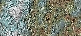
In astrogeology, chaos terrain, or chaotic terrain, is a planetary surface area where features such as ridges, cracks, and plains appear jumbled and enmeshed with one another. Chaos terrain is a notable feature of the planets Mars and Mercury, Jupiter's moon Europa, and the dwarf planet Pluto. In scientific nomenclature, "chaos" is used as a component of proper nouns.

<span class="mw-page-title-main">Arcadia Planitia</span> Plain on Mars

Arcadia Planitia is a smooth plain with fresh lava flows and Amazonian volcanic flows on Mars. It was named by Giovanni Schiaparelli in 1882 after the Arcadia region of ancient Greece. It dates from the Amazonian period's Arcadia formation's lava flows and small cinder cones. It includes a more recently developed large region of aeolian materials derived from periglacial processes.

<span class="mw-page-title-main">Coprates quadrangle</span> Map of Mars

The Coprates quadrangle is one of a series of 30 quadrangle maps of Mars used by the United States Geological Survey (USGS) Astrogeology Research Program. The Coprates quadrangle is also referred to as MC-18. The Coprates quadrangle contains parts of many of the old classical regions of Mars: Sinai Planum, Solis Planum, Thaumasia Planum, Lunae Planum, Noachis Terra, and Xanthe Terra.

<span class="mw-page-title-main">Dark slope streak</span> Surface feature of Mars

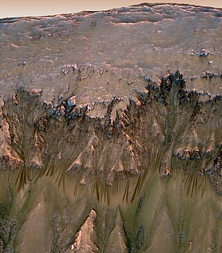
Dark slope streaks are narrow, avalanche-like features common on dust-covered slopes in the equatorial regions of Mars. They form in relatively steep terrain, such as along escarpments and crater walls. Although first recognized in Viking Orbiter images from the late 1970s, dark slope streaks were not studied in detail until higher-resolution images from the Mars Global Surveyor (MGS) and Mars Reconnaissance Orbiter (MRO) spacecraft became available in the late 1990s and 2000s.

<span class="mw-page-title-main">Seasonal flows on warm Martian slopes</span> Surface features on Mars

Seasonal flows on warm Martian slopes are thought to be salty water flows occurring during the warmest months on Mars, or alternatively, dry grains that "flow" downslope of at least 27 degrees.

<span class="mw-page-title-main">Evidence of water on Mars found by Mars Reconnaissance Orbiter</span>

The Mars Reconnaissance Orbiter's HiRISE instrument has taken many images that strongly suggest that Mars has had a rich history of water-related processes. Many features of Mars appear to be created by large amounts of water. That Mars once possessed large amounts of water was confirmed by isotope studies in a study published in March 2015, by a team of scientists showing that the ice caps were highly enriched with deuterium, heavy hydrogen, by seven times as much as the Earth. This means that Mars has lost a volume of water 6.5 times what is stored in today's polar caps. The water for a time would have formed an ocean in the low-lying Mare Boreum. The amount of water could have covered the planet about 140 meters, but was probably in an ocean that in places would be almost 1 mile deep.

The common surface features of Mars include dark slope streaks, dust devil tracks, sand dunes, Medusae Fossae Formation, fretted terrain, layers, gullies, glaciers, scalloped topography, chaos terrain, possible ancient rivers, pedestal craters, brain terrain, and ring mold craters.

<span class="mw-page-title-main">Garni (crater)</span> Crater on Mars

Garni is an impact crater on Mars, in which, according to NASA, there is evidence of liquid water. In the press release of its finding on 28 September 2015, NASA considered it "the latest of many breakthroughs" in their Mars exploration. NASA and the US Geological Survey named the crater after the Armenian village of Garni. The naming was approved and adopted by the International Astronomical Union (IAU) on April 24, 2015.

The following outline is provided as an overview of and topical guide to Jupiter: