This article relies largely or entirely on a single source .(October 2015) |
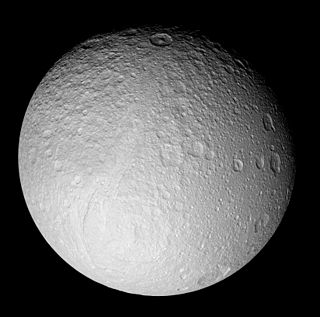
This is a list of named geological features on Tethys . Tethyan geological features are named after people and places in Homer's The Iliad and The Odyssey .
This article relies largely or entirely on a single source .(October 2015) |
This is a list of named geological features on Tethys . Tethyan geological features are named after people and places in Homer's The Iliad and The Odyssey .
There are two named chasmata on Tethys.
| Chasma | Pronounced | Coordinates | Length (km) | Approval Date | Named After | Refs |
|---|---|---|---|---|---|---|
| Ithaca Chasma | /ˈɪθəkə/ | 14°00′S6°06′E / 14°S 6.1°E | 1219 | 1982 | Ithaca | WGPSN |
| Ogygia Chasma | /oʊˈdʒɪdʒiə/ | 56°00′N95°12′E / 56°N 95.2°E | 120 | 2008 | Ogygia | WGPSN |
The central complex of the Odysseus basin is called Scheria Montes.
| Montes | Pronounced | Coordinates | Size, km | Approval Date | Named After | Refs |
|---|---|---|---|---|---|---|
| Scheria Montes | /ˈskɪəriə/ | 30°N131°E / 30°N 131°E | 1859 | 2008 | Scheria | WGPSN |

Tethys, or Saturn III, is the fifth-largest moon of Saturn, measuring about 1,060 km (660 mi) across. It was discovered by Giovanni Domenico Cassini in 1684, and is named after the titan Tethys of Greek mythology.

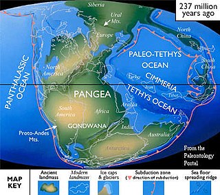
The Tethys Ocean, also called the Tethys Sea or the Neo-Tethys, was a prehistoric ocean during much of the Mesozoic Era and early-mid Cenozoic Era. It was the predecessor to the modern Indian Ocean, the Mediterranean Sea, and the Eurasian inland marine basins.

Eduard Suess was an Austrian geologist and an expert on the geography of the Alps. He is responsible for hypothesising two major former geographical features, the supercontinent Gondwana and the Tethys Ocean.
This is a directory of lists of geological features on planets excepting Earth, moons and asteroids ordered by increasing distance from the Sun.

Odysseus is the largest crater on Saturn's moon Tethys. It is 445 km across, more than 2/5 of the moon's diameter, and is one of the largest craters in the Solar System. It is situated in the western part of the leading hemisphere of the moon—the latitude and longitude of its center are 32.8°N and 128.9°W, respectively. It is named after the Greek hero Odysseus from Homer's the Iliad and the Odyssey.

Ithaca Chasma is a valley (graben) of Saturn's moon Tethys, named after the island of Ithaca, in Greece. It is up to 100 km (62 mi) wide, 3–5 km (1.9–3.1 mi) deep and 2,000 km (1,200 mi) long, running approximately three-quarters of the way around Tethys' circumference, making it one of the longer valleys in the Solar System. Ithaca Chasma is approximately concentric with Odysseus crater.
The Lopingian is the uppermost series/last epoch of the Permian. It is the last epoch of the Paleozoic. The Lopingian was preceded by the Guadalupian and followed by the Early Triassic.

The geology of Europe is varied and complex, and gives rise to the wide variety of landscapes found across the continent, from the Scottish Highlands to the rolling plains of Hungary. Europe's most significant feature is the dichotomy between highland and mountainous Southern Europe and a vast, partially underwater, northern plain ranging from England in the west to the Ural Mountains in the east. These two halves are separated by the Pyrenees and the Alps-Carpathians mountain chain. The northern plains are delimited in the west by the Scandinavian Mountains and the mountainous parts of the British Isles. The southern mountainous region is bounded by the Mediterranean Sea and the Black Sea. Major shallow water bodies submerging parts of the northern plains are the Celtic Sea, the North Sea, the Baltic Sea and the Barents Sea.

The Paleo-Tethys or Palaeo-Tethys Ocean was an ocean located along the northern margin of the paleocontinent Gondwana that started to open during the Middle Cambrian, grew throughout the Paleozoic, and finally closed during the Late Triassic; existing for about 400 million years.

Cimmeria was an ancient continent, or, rather, a string of microcontinents or terranes, that rifted from Gondwana in the Southern Hemisphere and was accreted to Eurasia in the Northern Hemisphere. It consisted of parts of present-day Turkey, Iran, Afghanistan, Pakistan, Tibet, China, Myanmar, Thailand, and Malaysia. Cimmeria rifted from the Gondwanan shores of the Paleo-Tethys Ocean during the Early Permian and as the Neo-Tethys Ocean opened behind it, during the Permian, the Paleo-Tethys closed in front of it. Because the different chunks of Cimmeria drifted northward at different rates, a Meso-Tethys Ocean formed between the different fragments during the Cisuralian. Cimmeria rifted off Gondwana from east to west, from Australia to the eastern Mediterranean. It stretched across several latitudes and spanned a wide range of climatic zones.

The geological history of the Earth follows the major geological events in Earth's past based on the geological time scale, a system of chronological measurement based on the study of the planet's rock layers (stratigraphy). Earth formed about 4.54 billion years ago by accretion from the solar nebula, a disk-shaped mass of dust and gas left over from the formation of the Sun, which also created the rest of the Solar System.
In planetary nomenclature, a chasma is a deep, elongated, steep-sided depression. As of 2020, the IAU has named 122 such features in the Solar System, on Venus (63), Mars (25), Saturn's satellites Mimas (6), Tethys (2), Dione (8) and Rhea (5), Uranus's satellites Ariel (7), Titania (2) and Oberon (1) and Pluto's satellite Charon (3). An example is Eos Chasma on Mars.

Pangaea or Pangea was a supercontinent that existed during the late Paleozoic and early Mesozoic eras. It assembled from the earlier continental units of Gondwana, Euramerica and Siberia during the Carboniferous approximately 335 million years ago, and began to break apart about 200 million years ago, at the end of the Triassic and beginning of the Jurassic. In contrast to the present Earth and its distribution of continental mass, Pangaea was C-shaped, with the bulk of its mass stretching between Earth's northern and southern polar regions and surrounded by the superocean Panthalassa and the Paleo-Tethys and subsequent Tethys Oceans. Pangaea is the most recent supercontinent to have existed and the first to be reconstructed by geologists.

Mons is a mountain on a celestial body. The term is used in planetary nomenclature: it is a part of the international names of such features. It is capitalized and usually stands after the proper given name, but stands before it in the case of lunar mountains.
The following outline is provided as an overview of and topical guide to Saturn:
The geology of Bhutan is less well studied than many countries in Asia, together with the broader Eastern Himalayas region. Older Paleozoic and Precambrian rocks often appear mixed together with younger sediments due to the Himalayan orogeny.
The geology of Romania is structurally complex, with evidence of past crustal movements and the incorporation of different blocks or platforms to the edge of Europe, driving recent mountain building of the Carpathian Mountains. Romania is a country located at the crossroads of Central, Eastern, and Southeastern Europe. It borders the Black Sea to the southeast, Bulgaria to the south, Ukraine to the north, Hungary to the west, Serbia to the southwest, and Moldova to the east.