Related Research Articles

Muztagh Tower, also: Mustagh Tower; Muztagh: ice tower), is a mountain in the Baltoro Muztagh, part of the Karakoram range in Baltistan on the border of the Gilgit–Baltistan region of Pakistan and the Xinjiang Uyghur Autonomous Region of China. It stands between the basins of the Baltoro and Sarpo Laggo glaciers.

Ladakh is a region administered by India as a union territory, which constitutes a part of the larger Kashmir region and has been the subject of dispute between India, Pakistan, and China since 1947. Ladakh is bordered by the Tibet Autonomous Region to the east, the Indian state of Himachal Pradesh to the south, both the Indian-administered union territory of Jammu and Kashmir and the Pakistan-administered Gilgit-Baltistan to the west, and the southwest corner of Xinjiang across the Karakoram Pass in the far north. It extends from the Siachen Glacier in the Karakoram range to the north to the main Great Himalayas to the south. The eastern end, consisting of the uninhabited Aksai Chin plains, is claimed by the Indian Government as part of Ladakh, and has been under Chinese control since 1962.

The Trans-Karakoram Tract, also known as the Shaksgam Tract, is an area of approximately 5,300 km2 (2,050 sq mi) north of the Karakoram watershed, including the Shaksgam valley. The tract is administered by China as part of its Taxkorgan and Yecheng counties in the Xinjiang Uyghur Autonomous Region. Although the Shaksgam tract was never under the control of Pakistan since 1947, in the 1963 Sino-Pakistan Agreement, Pakistan recognized Chinese sovereignty over the Shaksgam tract, while China recognized Pakistani sovereignty over the Gilgit Agency, and a border based on actual ground positions was recognized as the international border by China and Pakistan. It is claimed by India as part of the Union territory of Ladakh.

Mount Tate, commonly referred to as Tateyama, is a mountain located in the southeastern area of Toyama Prefecture, Japan. It is one of the tallest mountains in the Hida Mountains at 3,015 m (9,892 ft). It is one of the Japan's "Three Holy Mountains" along with Mount Fuji and Mount Haku. Tateyama consists of three peaks: Ōnanjiyama, Oyama, and Fuji-no-Oritateyama, which run along a ridge. Tateyama is the tallest mountain in the Tateyama Mountain Range.

The Baltoro Glacier, at 63 km (39 mi) in length, is one of the longest glaciers outside the polar regions.

Puncak Trikora, until 1963 Wilhelmina Peak, is a 4,730 or 4,750-metre-high (15,584 ft) mountain in the Highland Papua province of Indonesia on New Guinea. It lies in the eastern part of the Sudirman (Nassau) Range of the Maoke Mountains.

The Biafo Glacier is a 67 km (42 mi)-long glacier situated in the Karakoram mountain range in Shigar district, Gilgit−Baltistan, Pakistan.

The Saltoro Mountains are a subrange of the Karakoram Range. They are located in the southeast Karakoram on the southwest side of the Siachen Glacier, one of the two longest glaciers outside the polar regions. The name given to this range is shared with the Saltoro Valley which is located to the west of this range, downslope on the Pakistan side of the Saltoro Range which generally follows the Actual Ground Position Line. Saltoro Kangri peak, Saltoro River, and Saltoro Valley are features on this range. The Actual Ground Position Line (AGPL) between Indian and Pakistan held area runs through this range, where the high peaks and passes of the Siachen area are held by India, whereas Pakistan occupies the lower peaks and valleys to the west.
Skyang Kangri, or Staircase Peak, is a high mountain peak of the Baltoro Muztagh, a subrange of the Karakoram range. It lies on the Pakistan–China border, about 7 kilometres (4.3 mi) northeast of K2, the world's second-highest mountain. The name "Staircase Peak" refers to the East Ridge, which resembles a giant staircase with five steps.

Puncak Jaya Regency is one of the regencies (kabupaten) in the Indonesian province of Central Papua. It is an inland highland regency, lying directly east of Paniai Regency and west of Jayawijaya Regency and Tolikara Regency. As of 2004, it was reported that these four regencies had a population that is 93–97% ethnic Papua; however this included areas which have subsequently been formed into new regencies.
Puncak Jaya or Carstensz Pyramid, Mount Jayawijaya or Mount Carstensz on the island of New Guinea, with an elevation of 4,884 m (16,024 ft), is the highest mountain peak of an island on Earth. The mountain is located in the Sudirman Range of the highlands of Central Papua, Indonesia, in the southwest of Puncak Jaya Regency.
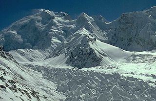
The West Northwall Firn was a glacial body on Mount Carstensz in the Sudirman Range on the island of New Guinea in Central Papua province, Indonesia. The glacier was situated at an elevation of approximately 4,600 metres (15,100 ft) to 4,750 metres (15,580 ft), centered a little over 3 kilometres (1.9 mi) northwest of Ngga Pulu and 5 kilometres (3.1 mi) of Puncak Jaya, the highest peak of Oceania.
The East Northwall Firn was a glacier on Mount Carstensz in the Sudirman Range on the island of New Guinea in Central Papua province, Indonesia. Situated at an elevation of approximately 4,750 metres (15,580 ft) 2.5 kilometres (1.6 mi) NNW of Puncak Jaya, the highest summit in Oceania. It broke up in three patches in or before 2017.
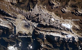
The Carstensz Glacier is near the peak of Puncak Jaya which is a mountain in the Sudirman Range of the island of New Guinea, territorially the eastern highlands of Central Papua, Indonesia. The glacier is situated at an elevation of approximately 4,600 metres (15,100 ft) and is 1.5 kilometres (0.93 mi) east of the summit tower of Puncak Jaya. In 2002 the Carstensz Glacier was 1.4 kilometres (0.87 mi) in length and .60 kilometres (0.37 mi) wide.

Ngga Pulu is a summit on the north rim of Mount Carstensz in the western part of the island of New Guinea rising 4,862 metres (15,951 ft). Trigonometric measurements showed that Ngga Pulu was the highest mountain of New Guinea and also the highest summit of the Australia-New Guinea continent. The elevation of Ngga Pulu in 1936 was about 4,907 m (16,099 ft), and it was the highest and most prominent peak between the Himalaya and the Andes. However, due to glacial melting, Ngga Pulu lost a lot of elevation in the 20th century.

Sumantri Peak is a sharp mountain in the western Sudirman Range (Papua). It rises 4,870 metres (15,978 ft).
Kangri Karpo, also spelt Gangri Garbo, is a mountain range in eastern Tibet, located primarily in Nyingchi Prefecture as well as a portion of Qamdo Prefecture in the Tibet Autonomous Region, China. The mountain range lies to the east of the Himalayas and to the west of the Hengduan Mountains. The mountains are geographically a southern extension of the eastern Transhimalayas.
References
- ↑ "ingentaconnect Retreat of glaciers on Puncak Jaya, Irian Jaya, determined from 2..." www.ingentaconnect.com. Archived from the original on 2011-06-07.
- ↑ "Archived copy" (PDF). Archived from the original (PDF) on 2017-05-17. Retrieved 2009-01-29.
{{cite web}}: CS1 maint: archived copy as title (link)