List of highest railway stations in Switzerland

Last updated

The Gornergrat railway station, the highest (open-air) railway station building on the continent Gornergrat railway station.jpg
The Gornergrat railway station, the highest (open-air) railway station building on the continent

This is a list of railway stations in Switzerland located at an elevation over 1,200 metres above sea level. Switzerland includes most of the highest railways of Europe and therefore also includes its highest railway stations, both underground and open-air, on dead-end rail and on rail crossing. With the notable exception of the region of Graubünden, where are some of the highest European towns connected to railways, most of these stations are on railways that primarily carry tourists and are not used by commuters.

Contents

In the list are indicated the elevation, municipality, canton, railway and nearest location, inhabited or not.

For a list of the highest railways, see List of mountain railways in Switzerland. Note that this list does not include funicular nor any cable transport related facilities. For a list of funiculars, see List of funiculars in Switzerland. For a list of aerial tramways, see List of aerial tramways in Switzerland.

Main list

Station Elevation Canton Municipality RailwayLocationNotes
Jungfraujoch 3,454 m (11,332 ft) Valais Fieschertal Jungfrau Jungfraujoch Terminus, underground, highest station in Europe
Eismeer 3,160 m (10,367 ft) Bern Grindelwald Jungfrau EismeerUnderground, second highest station in Europe
Gornergrat 3,090 m (10,138 ft) Valais Zermatt Gornergrat Gornergrat Terminus, third highest station in Europe, highest open-air station in Europe
Eigerwand 2,865 m (9,400 ft) Bern Grindelwald Jungfrau Eiger north faceUnderground
Rotenboden 2,815 m (9,236 ft) Valais Zermatt Gornergrat RotenbodenSecond highest open-air station in Europe
Riffelberg 2,582 m (8,471 ft) Valais Zermatt Gornergrat RiffelbergThird highest open-air station in Europe
Eigergletscher 2,320 m (7,612 ft) Bern Lauterbrunnen Jungfrau Eiger Glacier
Ospizio Bernina 2,253 m (7,392 ft) Graubünden Poschiavo Bernina Ospizio BerninaRail crossing (summit), highest rail mountain pass in Europe, [1] highest station in Eastern Switzerland
Brienzer Rothorn2,244 m (7,362 ft) Bern Brienz Brienz–Rothorn Brienzer Rothorn Terminus
Riffelalp Resort2,222 m (7,290 ft) Valais Zermatt Riffelalp tram Riffelalp Resort
Riffelalp 2,211 m (7,254 ft) Valais Zermatt Gornergrat/Riffelalp tram Riffelalp Highest station in Europe with two distinct railways
Furka 2,163 m (7,096 ft) Uri Realp Furka Cogwheel Steam Railway East portal of Furka Summit Tunnel Rail crossing (summit), highest station in Central Switzerland
Muttbach-Belvédère 2,118 m (6,949 ft) Valais Obergoms Furka Cogwheel Steam Railway West portal of Furka Summit Tunnel
Bernina Lagalb 2,100 m (6,890 ft) Graubünden Pontresina Bernina Bernina Lagalb
Bernina Diavolezza 2,093 m (6,867 ft) Graubünden Pontresina Bernina Bernina Diavolezza
Alp Grüm 2,091 m (6,860 ft) Graubünden Poschiavo Bernina Alp Grüm
Bernina Suot 2,046 m (6,713 ft) Graubünden Pontresina Bernina Bernina Suot
Pilatus Kulm2,073 m (6,801 ft) Obwalden Alpnach Pilatus Pilatus Terminus
Kleine Scheidegg 2,061 m (6,762 ft) Bern Lauterbrunnen Wengernalp/Jungfrau Kleine Scheidegg Rail crossing (summit), highest railway hub in Switzerland [2] (and Europe)
Oberalp Pass 2,033 m (6,670 ft) Uri Andermatt Andermatt–Chur Oberalp Pass Rail crossing (summit)
Rochers de Naye1,968 m (6,457 ft) Vaud Veytaux Montreux–Glion–Rochers-de-Naye Rochers de Naye Terminus
Schynige Platte 1,967 m (6,453 ft) Bern Gündlischwand Schynige Platte Schynige Platte Terminus
Morteratsch 1,896 m (6,220 ft) Graubünden Pontresina Bernina Morteratsch
Wengernalp 1,874 m (6,148 ft) Bern Lauterbrunnen Wengernalp Wengernalp
Tiefenbach 1,845 m (6,053 ft) Uri Realp Furka Cogwheel Steam Railway Tiefenbach
Nätschen 1,842 m (6,043 ft) Uri Andermatt Andermatt–Chur Nätschen
Surovas 1,822 m (5,978 ft) Graubünden Pontresina Bernina Pontresina (Surovas)
Les Montuires1,822 m (5,978 ft) Valais Finhaut Les Montuires–EmossonLes MontuiresTerminus
Pied du Barrage1,820 m (5,971 ft) Valais Finhaut Les Montuires–Emosson Emosson Dam baseTerminus
Spinas 1,815 m (5,955 ft) Graubünden Bever Albula Spinas
Bretaye1,806 m (5,925 ft) Vaud Ollon Bex–Villars–Bretaye Col de Bretaye Terminus
La Perche1,795 m (5,889 ft) Vaud Montreux Montreux–Glion–Rochers-de-Naye La Perche
Preda 1,789 m (5,869 ft) Graubünden Bergün Albula Preda
St. Moritz 1,775 m (5,823 ft) Graubünden St. Moritz Albula/Bernina St. Moritz Highest town station in Europe [Nb 1]
Pontresina 1,774 m (5,820 ft) Graubünden Pontresina Bernina/Pontresina–Scuol-Tarasp Pontresina
Findelbach 1,770 m (5,807 ft) Valais Zermatt Gornergrat Findelbach
Gletsch 1,762 m (5,781 ft) Valais Obergoms Furka Cogwheel Steam Railway Gletsch
Bouquetins1,759 m (5,771 ft) Vaud Ollon Bex–Villars–Bretaye Bouquetins
Rigi Kulm1,752 m (5,748 ft) Schwyz Arth Rigi Rigi Kulm Terminus
Arosa 1,739 m (5,705 ft) Graubünden Arosa Chur-Arosa Arosa Terminus
Jaman1,739 m (5,705 ft) Vaud Montreux Montreux–Glion–Rochers-de-Naye Montagne d'Amont
Celerina 1,730 m (5,676 ft) Graubünden Celerina Albula Celerina
Punt Muragl Staz 1,729 m (5,673 ft) Graubünden Celerina Bernina Pontresina (Muragl)
Punt Muragl 1,728 m (5,669 ft) Graubünden Samedan Pontresina–Scuol-Tarasp Pontresina (Muragl)
Celerina Staz 1,716 m (5,630 ft) Graubünden Celerina Bernina Celerina
Bever 1,710 m (5,610 ft) Graubünden Bever Albula/Pontresina–Scuol-Tarasp Bever
Samedan 1,705 m (5,594 ft) Graubünden Samedan Albula/Pontresina–Scuol-Tarasp Samedan
Tschamut-Selva 1,702 m (5,584 ft) Graubünden Tujetsch Andermatt–Chur Tschamut
La Punt Chamues-ch 1,697 m (5,568 ft) Graubünden La Punt Chamues-ch Pontresina–Scuol-Tarasp La Punt
Madulain 1,697 m (5,568 ft) Graubünden Madulain Pontresina–Scuol-Tarasp Madulain
Cavaglia 1,692 m (5,551 ft) Graubünden Poschiavo Bernina Cavaglia
Zuoz 1,692 m (5,551 ft) Graubünden Zuoz Pontresina–Scuol-Tarasp Zuoz
S-chanf 1,670 m (5,479 ft) Graubünden S-chanf Pontresina–Scuol-Tarasp S-chanf
Mürren 1,639 m (5,377 ft) Bern Lauterbrunnen Grütschalp–Mürren Mürren Terminus
Villars-sur-Ollon Golf1,629 m (5,344 ft) Vaud Ollon Bex–Villars–Bretaye Golf de Villars
Cinuos-chel-Brail 1,628 m (5,341 ft) Graubünden S-chanf Pontresina–Scuol-Tarasp Cinuos-chel
Davos Wolfgang 1,625 m (5,331 ft) Graubünden Davos Landquart–Klosters–Davos Davos (Wolfgang)
Alpiglen 1,616 m (5,302 ft) Bern Grindelwald Wengernalp Alpligen
Zermatt/Zermatt GGB 1,605 m (5,266 ft) Valais Zermatt Visp–Zermatt/Gornergrat Zermatt Two distinct stations with a rail link
Rigi Staffel 1,603 m (5,259 ft) Schwyz Arth Rigi Rigi Staffel
Generoso Vetta 1,601 m (5,253 ft) Ticino Castel San Pietro Monte Generoso Monte Generoso Terminus
Winteregg 1,578 m (5,177 ft) Bern Lauterbrunnen Grütschalp–Mürren Winteregg
Davos Dorf 1,560 m (5,118 ft) Graubünden Davos Landquart–Klosters–Davos Davos (Dorf)
Rigi Staffelhöhe1,550 m (5,085 ft) Lucerne Weggis Rigi Rigi Staffelhöhe
Breitlauenen 1,542 m (5,059 ft) Bern Gsteigwiler Schynige Platte Breitlauenen
Davos Platz 1,540 m (5,052 ft) Graubünden Davos Landquart–Klosters–Davos Davos (Platz)
Realp 1,538 m (5,046 ft) Uri Realp Brig–Andermatt/Furka Cogwheel Steam Railway Realp
Col de Soud1,524 m (5,000 ft) Vaud Ollon Bex–Villars–Bretaye Col de Soud
Davos Laret 1,522 m (4,993 ft) Graubünden Davos Landquart–Klosters–Davos Davos (Laret)
Allmend 1,509 m (4,951 ft) Bern Lauterbrunnen Wengernalp Allmend
Davos Frauenkirch 1,505 m (4,938 ft) Graubünden Davos Davos–Filisur Davos (Frauenkirch)
Grütschalp 1,487 m (4,879 ft) Bern Lauterbrunnen Grütschalp–Mürren Grütschalp Terminus
Rigi First1,480 m (4,856 ft) Lucerne Arth Rigi Rigi First
Zernez 1,471 m (4,826 ft) Graubünden Zernez Pontresina–Scuol-Tarasp Zernez
Davos Glaris 1,455 m (4,774 ft) Graubünden Davos Davos–Filisur Davos (Glaris)
Hospental 1,452 m (4,764 ft) Uri Hospental Brig–Andermatt Hospental
Litzirüti 1,452 m (4,764 ft) Graubünden Arosa Chur-Arosa Litzirüti
Leysin Grand Hotel1,451 m (4,760 ft) Vaud Leysin Aigle–Leysin Leysin Terminus
Rueras 1,447 m (4,747 ft) Graubünden Tujetsch Andermatt–Chur Rueras
Dieni 1,442 m (4,731 ft) Graubünden Tujetsch Andermatt–Chur Dieni
Sedrun 1,441 m (4,728 ft) Graubünden Tujetsch Andermatt–Chur Sedrun
Täsch 1,438 m (4,718 ft) Valais Täsch Visp–Zermatt/Gornergrat Täsch
Andermatt 1,436 m (4,711 ft) Uri Andermatt Brig–Andermatt/Göschenen–Andermatt Andermatt
Susch 1,435 m (4,708 ft) Graubünden Susch Pontresina–Scuol-Tarasp Susch
Rigi Kaltbad1,433 m (4,701 ft) Lucerne Weggis Rigi Rigi Kaltbad
Bugnei 1,432 m (4,698 ft) Graubünden Tujetsch Andermatt–Chur Bugnei
Sagliains 1,432 m (4,698 ft) Graubünden Susch Pontresina–Scuol-Tarasp South portal of the Vereina Tunnel
Lavin 1,432 m (4,698 ft) Graubünden Lavin Pontresina–Scuol-Tarasp Lavin
Guarda 1,431 m (4,695 ft) Graubünden Guarda Pontresina–Scuol-Tarasp Guarda
Ardez 1,431 m (4,695 ft) Graubünden Ardez Pontresina–Scuol-Tarasp Ardez
Paccot1,430 m (4,692 ft) Vaud Montreux Montreux–Glion–Rochers-de-Naye Paccot
Randa 1,407 m (4,616 ft) Valais Randa Visp–Zermatt/Gornergrat Randa
Leysin Feydey1,400 m (4,593 ft) Vaud Leysin Aigle–Leysin Leysin
Cadera 1,383 m (4,537 ft) Graubünden Poschiavo Bernina Cadera
Bergün/Bravuogn 1,372 m (4,501 ft) Graubünden Bergün Albula Bergün
Oberwald 1,366 m (4,482 ft) Valais Obergoms Brig–Andermatt/Furka Cogwheel Steam Railway Oberwald
Ämsigen1,362 m (4,469 ft) Obwalden Alpnach Pilatus Pilatus
Les Pléiades1,360 m (4,462 ft) Vaud Blonay Vevey–Les Pléiades Les Pléiades Terminus
Münster 1,359 m (4,459 ft) Valais Münster-Geschinen Brig–Andermatt Münster
Obergesteln 1,354 m (4,442 ft) Valais Obergoms Brig–Andermatt Obergesteln
Cavadürli 1,352 m (4,436 ft) Graubünden Klosters Landquart–Klosters–Davos Cavadürdli
Ulrichen 1,347 m (4,419 ft) Valais Obergoms Brig–Andermatt Ulrichen
Davos Monstein 1,346 m (4,416 ft) Graubünden Davos Davos–Filisur Davos (Monstein)
Mumpé Tujetsch 1,344 m (4,409 ft) Graubünden Disentis Andermatt–Chur Mumpé Tujetsch
Planalp1,341 m (4,400 ft) Bern Brienz Brienz–Rothorn Planalp
Geschinen 1,340 m (4,396 ft) Valais Münster-Geschinen Brig–Andermatt Geschinen
Ftan 1,335 m (4,380 ft) Graubünden Ftan Pontresina–Scuol-Tarasp Ftan
Brandegg 1,333 m (4,373 ft) Bern Grindelwald Wengernalp Brandegg
Langwies 1,317 m (4,321 ft) Graubünden Arosa Chur-Arosa Langwies
Reckingen 1,316 m (4,318 ft) Valais Reckingen-Gluringen Brig–Andermatt Reckingen
Rigi Klösterli1,316 m (4,318 ft) Schwyz Arth Rigi Rigi Klösterli
Gluringen 1,310 m (4,298 ft) Valais Reckingen-Gluringen Brig–Andermatt Gluringen
Scuol-Tarasp 1,287 m (4,222 ft) Graubünden Scuol Pontresina–Scuol-Tarasp Scuol
Crêt d'y Bau1,286 m (4,219 ft) Vaud Montreux Montreux–Glion–Rochers-de-Naye Crêt d'y Bau
Biel 1,283 m (4,209 ft) Valais Grafschaft Brig–Andermatt Biel
Breitmatten1,280 m (4,199 ft) Valais St. Niklaus Visp–Zermatt Breitmatten
Segnas 1,276 m (4,186 ft) Graubünden Disentis Andermatt–Chur Segnas
Wengen 1,275 m (4,183 ft) Bern Lauterbrunnen Wengernalp Wengen
Blitzingen 1,270 m (4,167 ft) Valais Blitzingen Brig–Andermatt Blitzingen
Leysin Village1,270 m (4,167 ft) Vaud Leysin Aigle–Leysin Leysin
Saanenmöser 1,269 m (4,163 ft) Bern Saanen Montreux–Oberland Bernois Saanenmöser Rail crossing (near summit)
Herbriggen 1,255 m (4,117 ft) Valais St. Niklaus Visp–Zermatt Herbriggen
Villars-sur-Ollon1,253 m (4,111 ft) Vaud Ollon Bex–Villars–Bretaye Villars-sur-Ollon
Niederwald 1,245 m (4,085 ft) Valais Niederwald Brig–Andermatt Niederwald
Peist 1,244 m (4,081 ft) Graubünden Arosa Chur-Arosa Peist
Lally1,240 m (4,068 ft) Vaud Blonay Vevey–Les Pléiades Lally
Arveyes1,231 m (4,039 ft) Vaud Ollon Bex–Villars–Bretaye Arveyes
Schönried1,230 m (4,035 ft) Bern Saanen Montreux–Oberland Bernois Schönried
Mattsand1,227 m (4,026 ft) Valais St. Niklaus Visp–Zermatt Mattsand
Finhaut 1,224 m (4,016 ft) Valais Finhaut Martigny–Châtelard Finhaut
Bellavista 1,222 m (4,009 ft) Ticino Mendrisio Monte Generoso Bellavista
La Clairière1,219 m (3,999 ft) Vaud Ollon Bex–Villars–Bretaye Arveyes
Goppenstein 1,216 m (3,990 ft) Valais Ferden Lötschberg Goppenstein Rail crossing (near summit), highest station of the main Swiss railway network [Nb 2]
La Barboleuse1,211 m (3,973 ft) Vaud Gryon Bex–Villars–Bretaye Gryon (La Barboleuse)
La Givrine1,208 m (3,963 ft) Vaud Saint-Cergue Nyon–St-Cergue–La Cure Col de la Givrine Rail crossing (near summit), highest station in the Jura Mountains
Acla da Fontauna 1,205 m (3,953 ft) Graubünden Disentis Andermatt–Chur Disentis (Acla da Fontauna)
Fürgangen-Bellwald Talstation 1,202 m (3,944 ft) Valais Bellwald Brig–Andermatt Fürgangen

See also

Notes

  1. The term "town" refers here to urban areas with a significant population. Other higher railway stations may be connected to several buildings such as restaurants or hotels.
  2. Adhesion and standard gauge railways

Related Research Articles

<span class="mw-page-title-main">Funicular</span> Form of cable railway

A funicular is a type of cable railway system that connects points along a railway track laid on a steep slope. The system is characterized by two counterbalanced carriages permanently attached to opposite ends of a haulage cable, which is looped over a pulley at the upper end of the track. The result of such a configuration is that the two carriages move synchronously: as one ascends, the other descends at an equal speed. This feature distinguishes funiculars from inclined elevators, which have a single car that is hauled uphill.

<span class="mw-page-title-main">Cable transport</span> Class of transport modes

Cable transport is a broad class of transport modes that have cables. They transport passengers and goods, often in vehicles called cable cars. The cable may be driven or passive, and items may be moved by pulling, sliding, sailing, or by drives within the object being moved on cableways. The use of pulleys and balancing of loads moving up and down are common elements of cable transport. They are often used in mountainous areas where cable haulage can overcome large differences in elevation.

<span class="mw-page-title-main">Aerial tramway</span> Aerial lift in which the cars are permanently fixed to the cables

An aerial tramway, sky tram,cable car, ropeway, aerial tram, telepherique, or seilbahn is a type of aerial lift which uses one or two stationary ropes for support while a third moving rope provides propulsion. With this form of lift, the grip of an aerial tramway cabin is fixed onto the propulsion rope and cannot be decoupled from it during operations. In comparison to gondola lifts, aerial tramways generally provide lower line capacities and higher wait times.

<span class="mw-page-title-main">Rail transport in Switzerland</span> Overview of rail transport in Switzerland

The Swiss rail network is noteworthy for its density, its coordination between services, its integration with other modes of transport, timeliness and a thriving domestic and trans-alp freight system. This is made necessary by strong regulations on truck transport, and is enabled by properly coordinated intermodal logistics.

<span class="mw-page-title-main">Lauterbrunnen–Mürren Mountain Railway</span> Transport system in the Bernese Oberland area of Switzerland

The Lauterbrunnen–Mürren Mountain Railway is a hybrid transport system in the Bernese Oberland area of Switzerland, which connects the villages of Lauterbrunnen and Mürren. The system consists of a connected aerial cableway, also known as the Grütschalpbahn, and an adhesion worked mountain railway. The cableway replaced a funicular, on the same route, in 2010.

<span class="mw-page-title-main">Pilatus Railway</span> Steepest rack railway in the world, in Switzerland

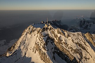
The Pilatus Railway is a mountain railway in Switzerland and the steepest rack railway in the world, with a maximum gradient of 48% and an average gradient of 35%. The line runs from Alpnachstad, on Lake Alpnach, to a terminus near the Esel summit of Pilatus at an elevation of 2,073 m (6,801 ft), which makes it the highest railway in the canton of Obwalden and the second highest in Central Switzerland after the Furka line. At Alpnachstad, the Pilatus Railway connects with steamers on Lake Lucerne and with trains on the Brünigbahn line of Zentralbahn.

<span class="mw-page-title-main">Säntis</span> Mountain in Switzerland

At 2,501.9 metres (8,208 ft) above sea level, Säntis is the highest mountain in the Alpstein massif of northeastern Switzerland. It is also the culminating point of the whole Appenzell Alps, between Lake Walen and Lake Constance. Shared by three cantons, the mountain is a highly visible landmark thanks to its exposed northerly position within the Alpstein massif. As a consequence, houses called Säntisblick can be found in regions as far away as the Black Forest in Germany. Säntis is among the most prominent summits in the Alps and the most prominent summit in Europe with an observation deck on the top. The panorama from the summit is spectacular. Six countries can be seen if the weather allows: Switzerland, Germany, Austria, Liechtenstein, France, and Italy.

<span class="mw-page-title-main">Schlieren, Switzerland</span> Municipality in Switzerland in Zurich

Schlieren is a municipality in the district of Dietikon in the canton of Zürich in Switzerland.

<span class="mw-page-title-main">Rail transport in Austria</span> Overview of the rail transport in Austria

Rail transport in Austria is mainly owned by the national rail company ÖBB. The railway network consists of 6,123 km, its gauge is 1,435 mmstandard gauge and 3,523 km are electrified.

<span class="mw-page-title-main">Stanserhorn</span> Mountain in Switzerland

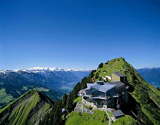
The Stanserhorn is a mountain in Switzerland, located in the canton of Nidwalden near to the border with Obwalden, with the peak at 1,898 metres (6,227 ft) above sea level.

<span class="mw-page-title-main">Transports publics de la région lausannoise</span>

Transports publics de la région lausannoise, often abbreviated simply to TL, are the main operator of public transport in Lausanne and the wider agglomeration. As of 2012, TL operates a network of 10 trolleybus routes, 25 conventional bus routes and two métro lines, using more than 290 vehicles. TL operate weekend night services and demand responsive transport.

<span class="mw-page-title-main">Trams in Lugano</span> Lugano tramway network (1896-1964)

The Lugano tramway network was part of the public transport network of Lugano, in the canton of Ticino, Switzerland, for over half a century. Opened in 1896, the network was progressively replaced by the Lugano trolleybus system by 1959, with one independent line surviving until 1964.

This article contains lists of tourist attractions in Switzerland.

References

  1. Nicola Williams, Damien Simonis, Kerry Walker. Switzerland (ebook Edition) . Lonely Planet
  2. 61512 Proceedings 2006/2007. IRSE Convention 2006: Interlaken, Switzerland. Institution of Railway Signal Engineers. Kleine Scheidegg, the highest railway junction in Switzerland