This is a list of islands of Nicaragua. There are 160 islands in Nicaragua on both the Caribbean Sea, Pacific Ocean and inland lakes. [1]

The Mosquito Coast, also known as the Mosquitia, Mosquito Shore and the Mosquito Kingdom, historically included the area along the eastern coast of present-day Nicaragua and Honduras. It formed part of the Western Caribbean Zone. It was named after the local Miskitu Nation and was long dominated by British interests. The Mosquito Coast was militarily incorporated into Nicaragua in November 1894; however, in 1960, the northern part was granted to Honduras by the International Court of Justice.

The Archipelago of San Andrés, Providencia and Santa Catalina, or San Andrés and Providencia, is one of the departments of Colombia, and the only one in North America. It consists of two island groups in the Caribbean Sea about 775 km (482 mi) northwest of mainland Colombia, and eight outlying banks and reefs. The largest island of the archipelago and Colombia is called San Andrés and its capital is San Andrés. The other large islands are Providencia and Santa Catalina Islands which lie to the north-east of San Andrés; their capital is Santa Isabel.

Bluefields is the capital of the South Caribbean Autonomous Region in Nicaragua. It was also the capital of the former Kingdom of Mosquitia, and later the Zelaya Department, which was divided into North and South Caribbean Coast Autonomous Regions. It is located on Bluefields Bay at the mouth of the Bluefields River in the municipality of the same name.
Mískito Coast Creole or Nicaragua Creole English is an English-based creole language spoken in coastal Nicaraguan region of Mosquito Coast on the Caribbean Sea; its approximately 30,000 speakers are spread over a number of small villages. The region is today administratively separated into two autonomous regions: North Caribbean Coast and South Caribbean Coast. Mosquito is the nickname that is given to the region and earlier residents by early Europeans who visited and settled in the area. The term "Miskito" is now more commonly used to refer to both the people and the language.
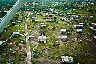
Puerto Cabezas is a municipality and city in Nicaragua. It is the capital of Miskito nation in the North Caribbean Coast Autonomous Region.

The Corn Islands are two islands about 70 kilometres (43 mi) east of the Caribbean coast of Nicaragua, constituting one of 12 municipalities of the South Caribbean Coast Autonomous Region. The official name of the municipality is Corn Island.

Grenadines is an administrative parish of Saint Vincent and the Grenadines, comprising the islands of the Grenadines other than those belonging to Grenada. The capital is Port Elizabeth.

Çınar is a district of Diyarbakır Province of Turkey. Its population is 74,207 according to Turkish government statistics as of 2018.

Rama Cay is an island in the Bluefields Lagoon on the eastern coast of Nicaragua. During the 17th or 18th century, the more powerful Miskito awarded the island to the Rama people in recognition of their assistance in fighting off the Terraba Indians.

Cay Sal Bank is the third largest and the westernmost of the Bahama Banks. It is located between 23º27'N - 24º10'N and 079º25'W – 080º35'W. In a geographical sense, it is separate from the Bahamas proper as it is much closer to Cuba than to the closest Bahamian island. It is separated by Santaren Channel from the Great Bahama Bank, the western rim of which is 50 km (31 mi) to the east. The Straits of Florida separate it from the United States mainland and the Florida Keys.

The Miskito Cays are an archipelago with an area of 27 km² located off shore in the northeastern Caribbean coast of Nicaragua, part of the North Caribbean Coast Autonomous Region. The Miskito Cays are composed of 76 formations that include estuaries, coral reefs, cays, seagrass beds, and islets, of which 12 of the formations are covered with vegetation and consequently form islands which are lined with white sand beaches.
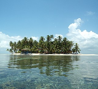
The Pearl Cays is a group of 18 cays located about 35 km (22 mi) from Pearl Lagoon off the Caribbean coast of Nicaragua. They are part of the South Caribbean Coast Autonomous Region. The Pearl Cays are covered with tropical vegetation and are lined with white sandy beaches. They are an important nesting site for turtles, including the critically endangered Hawksbill turtle.
The official language of Nicaragua is Spanish; however, Nicaraguans on the Caribbean coast speak indigenous languages and also English. The communities located on the Caribbean coast also have access to education in their native languages. Additionally, Nicaragua has four extinct indigenous languages.
Cayo Sur is a small uninhabited island less than two hectares in size located in the Caribbean sea. The surrounding area has an abundance of fish and oil.
Calala Island is a private island located in the Caribbean Sea, forming part of an archipelago of islands known as the Pearl Cays, off the coast of Nicaragua.

The Cayos Miskitos-San Andrés & Providencia moist forests ecoregion cover the forested areas of four islands in the western Caribbean Sea - Cayos Miskitos and the Corn Islands off the east coast of Nicaragua, and San Andrés and Providencia Islands farther east and belonging to the nation of Colombia. The forests on San Adres and Providencia have been heavily degraded by agriculture - coconuts on San Andres, oranges on Providencia. A significant feature of the ecoregion is the surrounding corals reefs, which are large and well preserved. While not technically a part of this terrestrial ecoregion, they are related to the islands.