List of municipalities in Amazonas by HDI

Last updated


This is a list of municipalities in Amazonas ordered by Human Development Index (HDI) according to data released by the United Nations Development Program (UNDP) of the United Nations for the 2010. [1] [2] The Human Development Index was developed in 1990 by the Pakistani economist Mahbub ul Haq and the Indian economist Amartya Sen. [3] [4]

Contents

According to the list. of the 62 municipalities in the state of Amazonas, none of them have very high HDI (equal to or greater than 0.800), 1 has high HDI (between 0.700 and 0.799), 14 have medium (between 0.600 and 0.699), 40 have low (between 0.500 and 0.599), and 7 have very low (less than 0.500). The HDI of Amazonas is 0.674 (considered medium). [5]

Criteria

Map of HDI of the municipalities of Amazonas.
Legend:
.mw-parser-output .legend{page-break-inside:avoid;break-inside:avoid-column}.mw-parser-output .legend-color{display:inline-block;min-width:1.25em;height:1.25em;line-height:1.25;margin:1px 0;text-align:center;border:1px solid black;background-color:transparent;color:black}.mw-parser-output .legend-text{}
Very high (no municipality)
High (1 municipality)
Medium (14 municipalities)
Low (40 municipalities)
Very low (7 municipalities) Mapa do IDH do Amazonas (2010).svg
Map of HDI of the municipalities of Amazonas.
Legend:
  Very high (no municipality)
  High (1 municipality)
  Medium (14 municipalities)
  Low (40 municipalities)
  Very low (7 municipalities)
Amazon Theatre in Manaus. Teatro Amazonas 2015.jpg
Amazon Theatre in Manaus.
Partial aerial view of Manaus. Manaus aerial view.jpg
Partial aerial view of Manaus.
Aerial view of the bridge over the Rio Negro that links Manaus to Iranduba. Vista aerea da ponte sobre o rio Negro que liga Manaus a Iranduba.jpg
Aerial view of the bridge over the Rio Negro that links Manaus to Iranduba.
View of the center of Parintins. C.N.S.C.jpg
View of the center of Parintins.
Monument in Urubui, Presidente Figueiredo Presidente Figueiredo - AM.jpg
Monument in Urubuí, Presidente Figueiredo
Sunset in Sao Gabriel da Cachoeira, a municipality nicknamed "Dog Head", in the northwest of Amazonas. Sao Gabriel da Cachoeira.jpg
Sunset in São Gabriel da Cachoeira, a municipality nicknamed "Dog Head", in the northwest of Amazonas.

Categories

The index varies from 0 to 1, considering:

Components

The HDI of the municipalities is an average between the income index,life expectancy index and educational index.

List

RankMunicipalitiesData of 2010
HDIChange

compared to 2010

data for 2000

Income

Index

Life ExpectancyIndexEducational Index
Very high HDI
no municipality
High HDI
1 Manaus 0.737Increase2.svg 0.1360.7380.8260.658
Medium HDI
2 Parintins 0.658Increase2.svg 0.1700.5890.8000.605
3 Itapiranga 0.654Increase2.svg 0.1760.5940.7920.594
4 Presidente Figueiredo 0.647Increase2.svg 0.1100.6270.8020.538
5 Itacoatiara 0.644Increase2.svg 0.1530.6180.8110.534
6 Tefé 0.639Increase2.svg 0.2010.6370.8010.511
7 Apuí 0.637Increase2.svg 0.2000.6210.7720.540
8 Silves 0.632Increase2.svg 0.1460.5460.7910.584
9 Urucará 0.620Increase2.svg 0.1330.5510.7540.575
10 Tabatinga 0.616Increase2.svg 0.1560.6020.7690.505
11 Manacapuru 0.614Increase2.svg 0.1770.6040.7950.481
12 Iranduba 0.613Increase2.svg 0.1760.6070.7990.476
13 Rio Preto da Eva 0.611Increase2.svg 0.1770.5900.7850.493
14 São Gabriel da Cachoeira 0.609Increase2.svg 0.1310.6100.7770.476
15 Humaitá 0.605Increase2.svg 0.1300.6210.7910.451
Low HDI
16 Manaquiri 0.596Increase2.svg 0.1670.5560.7480.510
17 Anamã 0.594Increase2.svg 0.1860.5370.7410.526
18 Boca do Acre 0.588Increase2.svg 0.1870.5760.7770.455
19 Maués 0.588Increase2.svg 0.1340.5490.8000.464
20 Urucurituba 0.588Increase2.svg 0.1610.5380.7760.487
21 Coari 0.586Increase2.svg 0.1970.6060.7800.425
22 Nhamundá 0.586Increase2.svg 0.1450.5130.7790.503
23 Manicoré 0.582Increase2.svg 0.1840.5800.7470.456
24 Autazes 0.577Increase2.svg 0.1570.5390.7990.456
25 São Sebastião do Uatumã 0.577Increase2.svg 0.1490.5610.7390.464
26 Barreirinha 0.574Increase2.svg 0.1750.4690.7740.522
27 Benjamin Constant 0.574Increase2.svg 0.1850.5260.7630.471
28 Novo Airão 0.570Increase2.svg 0.1420.5510.7760.434
29 Caapiranga 0.569Increase2.svg 0.1660.5440.7750.436
30 Careiro da Várzea 0.569Increase2.svg 0.1810.5230.7790.450
31 Boa Vista do Ramos 0.565Increase2.svg 0.1930.4960.7500.484
32 Codajás 0.563Increase2.svg 0.1230.5460.7750.421
33 Eirunepé 0.563Increase2.svg 0.1540.5480.7560.431
34 Anori 0.561Increase2.svg 0.1330.5400.7570.433
35 Amaturá 0.560´Increase2.svg 0.1470.4990.7730.455
36 Borba 0.560Increase2.svg 0.1710.5320.7760.425
37 Nova Olinda do Norte 0.558Increase2.svg 0.1850.5410.7800.412
38 Careiro 0.557Increase2.svg 0.2200.5150.7790.431
39 Novo Aripuanã 0.554Increase2.svg 0.1670.5320.7590.421
40 Carauari 0.549Increase2.svg 0.2050.5340.7450.416
41 Tonantins 0.548Increase2.svg 0.2210.5080.7790.416
42 Guajará 0.532Increase2.svg 0.1510.5100.7620.387
43 Lábrea 0.531Increase2.svg 0.1450.5380.7440.374
44 Canutama 0.530Increase2.svg 0.1500.5220.7520.379
45 Fonte Boa 0.530Increase2.svg 0.2100.5180.7190.400
46 Alvarães 0.527Increase2.svg 0.1540.4990.7780.377
47 Uarini 0.527Increase2.svg 0.1690.5350.7240.378
48 Japurá 0.522Increase2.svg 0.2180.5520.7480.345
49 Juruá 0.522Increase2.svg 0.1600.5380.7040.376
50 São Paulo de Olivença 0.521Increase2.svg 0.1970.4710.7800.386
51 Jutaí 0.516Increase2.svg 0.2120.5280.7660.340
52 Envira 0.509Increase2.svg 0.1630.5210.7270.349
53 Beruri 0.506Increase2.svg 0.1660.5120.7310.346
54 Tapauá 0.500Increase2.svg 0.2090.5450.7280.315
55 Barcelos 0.500Increase2.svg 0.1160.5450.7280.315
Very low HDI
56 Maraã 0.498Increase2.svg 0.2070.4660.7630.348
57 Pauini 0.496Increase2.svg 0.2090.5310.7240.317
58 Santo Antônio do Içá 0.496Increase2.svg 0.1840.4380.7590.353
59 Ipixuna 0.481Increase2.svg 0.1630.4760.7720.302
60 Santa Isabel do Rio Negro 0.479Increase2.svg 0.0950.4610.7370.323
61 Itamarati 0.477Increase2.svg 0.1460.5290.7720.266
62 Atalaia do Norte 0.450Increase2.svg 0.1020.4810.7330.259

Related Research Articles

<span class="mw-page-title-main">Human Development Index</span> Composite statistic of life expectancy, education, and income indices

The Human Development Index (HDI) is a statistical composite index of life expectancy, education, and per capita income indicators, which is used to rank countries into four tiers of human development. A country scores a higher level of HDI when the lifespan is higher, the education level is higher, and the gross national income GNI (PPP) per capita is higher. It was developed by Pakistani economist Mahbub ul-Haq and was further used to measure a country's development by the United Nations Development Programme (UNDP)'s Human Development Report Office.

<span class="mw-page-title-main">Jeremoabo</span> Municipality in Nordeste, Brazil

Jeremoabo is a municipality in the state of Bahia in the North-East region of Brazil.

<span class="mw-page-title-main">Itaúna</span> Municipality in Southeast, Brazil

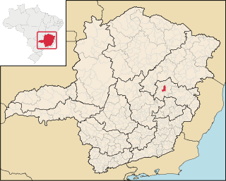
Itaúna is a municipality in the state of Minas Gerais in the Southeast region of Brazil.

<span class="mw-page-title-main">São João Evangelista</span> Municipality in Southeast, Brazil

São João Evangelista is a municipality in the state of Minas Gerais in the Southeast region of Brazil.

<span class="mw-page-title-main">Peçanha</span> Municipality in Southeast, Brazil

Peçanha is a municipality in the state of Minas Gerais in the Southeast region of Brazil.

<span class="mw-page-title-main">Pirapetinga</span> Municipality in Southeast, Brazil

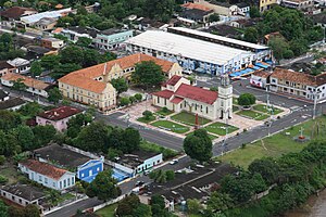
Pirapetinga is a municipality in the state of Minas Gerais in the Southeast region of Brazil. Its estimated population in 2020 was 10,772 inhabitants (IBGE).

<span class="mw-page-title-main">Rio Preto, Minas Gerais</span> Place in Southeast, Brazil

Rio Preto is a municipality in the state of Minas Gerais in the Southeast region of Brazil.

Rebouças is a municipality in the state of Paraná in the Southern Region of Brazil. Being filled with some hills in the surroundings and some parts of the city, the high structures are a tower in the hill of Mourão and the church in the city center., One dominant group of ethnicities in the city are Polish and Ukrainians.

<span class="mw-page-title-main">Ipueira</span> Municipality in Nordeste, Brazil

Ipueira is a municipality in the interior of the state of Rio Grande do Norte in the Northeast region of Brazil, in the region of Seridó. It is located 318 kilometers to the southwest of Natal, the state capital, and has an area of 127 km2 and is located at the midway point between Caicó and Patos. It has a population of 2,253 people, making it the third least populous municipal in the state.

<span class="mw-page-title-main">Tucumã, Pará</span> Municipality in Northern, Brazil

Tucumã is a municipality in the state of Pará in the Northern region of Brazil. It is located in the southeastern region of the state, approximately 882 km away from the capital. The town experienced significant population growth in the 1980s due to favorable agricultural conditions, timber exploitation, and gold extraction. It has a total area of 2,535.11 km² and is part of the now-extinct Grande Carajás Program. According to the latest data from 2020, Tucumã had a population of 40,136 inhabitants. The municipality has a medium Human Development Index (HDI) of 0.747 and a per capita income of R$ 15,452.90. Tucumã, along with the neighboring city of Ourilândia do Norte, forms the only conurbated area in the southeastern part of Pará.

References

  1. PNUD Brasil. "Índice de Desenvolvimento Humano Municipal, 2010 – Todos os Estados do Brasil" (PDF). Archived from the original (PDF) on 21 August 2013. Retrieved 29 July 2013.
  2. Atlas do Desenvolvimento Humano no Brasil 2013. "IDHM Municípios 2010". United Nations Development Programme . Retrieved 29 January 2017.{{cite web}}: CS1 maint: numeric names: authors list (link)
  3. "História do Relatório do Desenvolvimento Humano". United Nations Development Programme. Archived from the original on 3 April 2009. Retrieved 26 March 2009.
  4. "About HDRO". United Nations Development Programme. 2006. Archived from the original on 28 October 2006. Retrieved 20 December 2018.
  5. "2013 Human Development Atlas in Brazil". Database (in Portuguese). United Nations Development Programme. Retrieved 5 August 2013.

See also