List of municipalities in Sullivan County, Pennsylvania

Last updated

Map of Sullivan County, Pennsylvania with Municipal Labels showing Boroughs (red) and Townships (white) Map of Sullivan County Pennsylvania with Municipal and Township Labels.png
Map of Sullivan County, Pennsylvania with Municipal Labels showing Boroughs (red) and Townships (white)
Location of Sullivan County within Pennsylvania Map of Pennsylvania highlighting Sullivan County.svg
Location of Sullivan County within Pennsylvania

Sullivan County, Pennsylvania, United States, is divided into 13 incorporated municipalities. State law defines the two kinds of municipalities present in the county: four boroughs and nine townships. In the 2010 census, the population of Sullivan County was 6,428, [1] making it an "Eighth Class County", defined by Pennsylvania law as "having a population of less than 20,000 inhabitants". [2] Its county seat is Laporte, which was the smallest county seat in Pennsylvania by population, as of 2001. [3]

Contents

Sullivan County is located in north central Pennsylvania, about 123 miles (198 km) northwest of Philadelphia and 195 miles (314 km) east-northeast of Pittsburgh. [4] The county covers 452 square miles (1,170 km2), of which 450 square miles (1,165 km2) is land and 2 square miles (5.2 km2) (0.53%) is water. Its municipalities range in size from the borough of Dushore with 0.9 square miles (2.3 km2) to Davidson Township with 78.2 square miles (203 km2). Cherry Township has the highest population of any municipality (1,705 or 26.5% of the county total as of 2010), while the borough of Eagles Mere has the lowest population (120 or 1.9%). [1]

Although Sullivan County has boroughs and townships, it has no cities. Any municipality in Pennsylvania with more than 10 persons can incorporate as a borough. Any township or borough with a population of at least 10,000 can ask the state legislature to become chartered as a city. However, as Sullivan County has a population of only 6,428, it has no cities. There are no unincorporated areas in the county, since all territory in Pennsylvania is incorporated. [2]

History

The land which became Sullivan County was purchased from the Iroquois by the Province of Pennsylvania in 1768, as part of the first Treaty of Fort Stanwix. It was part of Northumberland County, then became part of Lycoming County when it was formed in 1795. [5] Sullivan County itself was formed from the northeastern part of Lycoming County on March 15, 1847. It was the thirteenth and last county formed at least partly from Lycoming County, and the fifth entirely formed from it. [5]

According to the official state publication The Pennsylvania Manual (2011), Sullivan County was named for Pennsylvania state senator Charles C. Sullivan, who "took an active part in procuring passage of the bill" establishing the county. [2] However, according to former Pennsylvania state librarian Frederic A. Godcharles (1933) and oliver P. Williams' County Courthouses of Pennsylvania: A Guide (2001), the county is named for General John Sullivan, who led the Sullivan Expedition against the Iroquois in 1779. [3] [6]

While all four boroughs were formed after Sullivan County was established, seven of the nine townships were formed while still part of Lycoming County. The first of these was Shrewsbury Township, which encompassed all of modern Sullivan County when it was formed in 1803. Elkland Township was formed from Shrewsbury in 1804, as were Cherry (1824), Davidson (1833), and Forks Townships (1833). Plunketts Creek Township was formed from Franklin and Davidson Townships in 1838, and Fox Township was formed from Elkland in 1839. When Sullivan County was formed in 1847, both Shrewsbury and Plunketts Creek Townships were split, with each county having a township of that name. Plunketts Creek Township in Sullivan County changed its name to Hillsgrove Township in 1856. [7] Sullivan County has no former townships, and no counties have been formed from it.

When formed in 1847, Sullivan County had no boroughs. The unincorporated village of Cherry Hill in Cherry Township served as the first county seat until 1850, when Laporte was founded in the geographic center of the county, and became its new county seat. [6] In 1850 the population of the county was 3,694 and it grew steadily to a peak of 12,134 in 1900. This was just after the borough of Eagles Mere was incorporated as the last of the county's municipalities, in 1899. [8] Much of this growth was fueled by lumber-based industry, but the virgin forests were almost all gone by 1900 and the population declined in eight of eleven decades since then, decreasing by a total of 47% between 1900 and 2010. [7] [9]

Municipalities

Incorporated municipalities of Sullivan County, Pennsylvania
Municipality
(type)
Remarks [5] [7] SettledIncorporated [10] Formed fromAreaPopulation (2010) [1] MapPhoto
Dushore (borough)Named for Aristide Aubert Du Petit Thouars, a French settler who built the first cabin. Dushore is a corruption of "Du Petit Thouars".1794 [7] 1859 Cherry Township [7] 0.9 sq mi
(2.3 km2)
608 Map of Sullivan County Pennsylvania Highlighting Dushore.png Dushore Pink.jpg
Eagles Mere (borough)Named for "Eagles Mere Lake" in its center, which was itself named for bald eagles and "mere", a term for a broad and shallow lake.1877 [10] 1899 Shrewsbury Township [10] 2.2 sq mi
(5.8 km2)
120 Map of Sullivan County Pennsylvania Highlighting Eagles Mere.png Eagles Mere, Pennsylvania.jpg
Forksville (borough)Named for the confluence ("forks") of Little Loyalsock Creek with Loyalsock Creek in the borough.1794 [7] 1880 Forks Township [10] 1.5 sq mi
(3.9 km2)
145 Map of Sullivan County Pennsylvania Highlighting Forksville.png Forksville Covered Bridge Southwest.jpg
Laporte (borough)County seat; named for John Laporte, member of the U.S. House of Representatives and last surveyor general of Pennsylvania.1850 [6] [10] 1853 Laporte Township [7] 1.3 sq mi
(3.3 km2)
316 Map of Sullivan County Pennsylvania Highlighting Laporte.png Sullivan County Courthouse.jpg
Cherry Township Named for stands of old growth cherry trees or the village of Cherry Hill.1816 [6] [10] 1824 Shrewsbury Township, while part of Lycoming County [6] [10] 57.8 sq mi
(149.8 km2)
1,705 Map of Sullivan County Pennsylvania Highlighting Cherry Township.png Cherry Township Warmth.jpg
Colley Township Named for William Colley, local businessman and judge.1823 [10] 1849 Cherry Township [6] [10] 59.0 sq mi
(152.8 km2)
694 Map of Sullivan County Pennsylvania Highlighting Colley Township.png Sunset over Lake Ganoga.jpg
Davidson Township Named for Asher Davidson, an associate judge of Lycoming County.1806 [6] [10] 1833 Shrewsbury Township, while part of Lycoming County [7] 78.2 sq mi
(202.5 km2)
573 Map of Sullivan County Pennsylvania Highlighting Davidson Township.png Sonestwon Covered Bridge 9.jpg
Elkland Township Named for the elk that once lived in the area.1798 [6] [10] 1804 Shrewsbury Township, while part of Lycoming County [7] 38.7 sq mi
(100.2 km2)
577 Map of Sullivan County Pennsylvania Highlighting Elkland Township.png ET Backdrop.jpg
Forks Township Named for the confluence ("forks") of Little Loyalsock Creek with Loyalsock Creek, now in Forksville.1794 [10] 1833 Shrewsbury Township, while part of Lycoming County [7] 43.9 sq mi
(113.7 km2)
377 Map of Sullivan County Pennsylvania Highlighting Forks Township.png Worlds End State Park Pavilion.jpg
Fox Township Named for George Fox, the founder of the Religious Society of Friends.1800 [6] [10] 1839 Elkland Township, while part of Lycoming County [7] 38.6 sq mi
(100.0 km2)
358 Map of Sullivan County Pennsylvania Highlighting Fox Township.png Shunk PA.jpg
Hillsgrove Township Named for John Hill, a prominent early settler, and the village of Hillsgrove he founded as Plunketts Creek Township The name was changed in 1856. [7] 1786 [6] [10] 1838 [11] Davidson and Franklin Townships, while part of Lycoming County [11] 28.4 sq mi
(73.6 km2)
287 Map of Sullivan County Pennsylvania Highlighting Hillsgrove Township.png Hillsgrove Covered Bridge Portal and Side in 2012.jpg
Laporte Township Named for John LaPorte, member of the U.S. House of Representatives and last surveyor general of Pennsylvania.1830 [10] 1850 Cherry, Davidson and Shrewsbury Townships [6] [10] 53.7 sq mi
(139.2 km2)
349 Map of Sullivan County Pennsylvania Highlighting Laporte Township.png Laporte Township farm.jpg
Shrewsbury Township Named for Shrewsbury Township, New Jersey.1799 [10] 1803 Muncy Township, while part of Lycoming County [11] 48.1 sq mi
(124.5 km2)
319 Map of Sullivan County Pennsylvania Highlighting Shrewsbury Township.png Hunters Lake.jpg
Loyalsock State Forest High Knob Panorama.JPG
Panorama of the Loyalsock State Forest from the High Knob Panorama in Hillsgrove Township. Note the relatively level height of the horizon, as this area is part of the dissected Allegheny Plateau.

Clickable map

The map shown below is clickable; click on any municipality name to be redirected to the article for that borough or township.

Dushore
Eagles
Mere
Forksville
Laporte
Cherry Township
Colley Township
Davidson Township
Elkland Township
Forks Township
Fox Township
Hillsgrove Township
Laporte Township
Shrewsbury Township
Map of Sullivan County, Pennsylvania All Blank.png

See also

Related Research Articles

<span class="mw-page-title-main">Sullivan County, Pennsylvania</span> County in Pennsylvania, United States

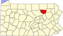
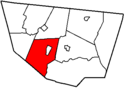
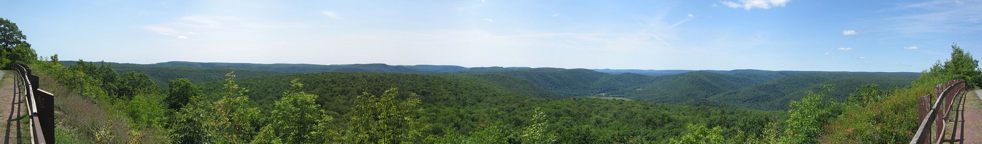
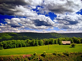
Sullivan County is a county in the Commonwealth of Pennsylvania. It is part of Northeastern Pennsylvania. As of the 2020 census, the population was 5,840, making it the second-least populous county in Pennsylvania. Its county seat is Laporte. The county was created on March 15, 1847, from part of Lycoming County and named for Major General John Sullivan.

<span class="mw-page-title-main">Lycoming County, Pennsylvania</span> County in Pennsylvania, United States

Lycoming County is a county in the Commonwealth of Pennsylvania. As of the 2020 census, the population was 114,188. Its county seat is Williamsport.

<span class="mw-page-title-main">Loyalsock Township, Pennsylvania</span> Township in Pennsylvania, United States

Loyalsock Township is a township in Lycoming County, Pennsylvania, United States. The population was 11,561 at the 2020 census. It is part of the Williamsport Metropolitan Statistical Area. It is the second largest municipality in Lycoming County, in terms of population, behind the county seat, Williamsport.

<span class="mw-page-title-main">Plunketts Creek Township, Pennsylvania</span> Township in Pennsylvania, United States

Plunketts Creek Township is a township in Lycoming County, Pennsylvania, United States. It includes the villages of Barbours and Proctor. The population was 595 at the 2020 census, down from 684 at the 2010 census. It is part of the Williamsport Metropolitan Statistical Area.

<span class="mw-page-title-main">Shrewsbury Township, Lycoming County, Pennsylvania</span> Township in Pennsylvania, United States

Shrewsbury Township is a township in Lycoming County, Pennsylvania, United States. The population was 419 at the 2020 census. It is part of the Williamsport Metropolitan Statistical Area.

<span class="mw-page-title-main">Dushore, Pennsylvania</span> Borough in Pennsylvania, United States

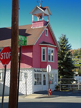
Dushore is a borough in Sullivan County, Pennsylvania, United States. The population was 450 at the 2020 census. Dushore is home to Sullivan County's only traffic light.

<span class="mw-page-title-main">Forks Township, Sullivan County, Pennsylvania</span> Township in Pennsylvania, United States

Forks Township is a township in Sullivan County, Pennsylvania, United States. The population was 372 at the 2020 census.

<span class="mw-page-title-main">Forksville, Pennsylvania</span> Borough in Pennsylvania, United States

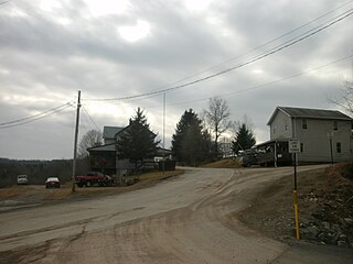
Forksville is a borough in Sullivan County, Pennsylvania, United States. The population was 110 at the 2020 census. It is the home of the 150-year-old Forksville General Store, down the road from the Sullivan County Fairgrounds, and near Worlds End State Park. The name comes from the confluence of Little Loyalsock Creek and Loyalsock Creek within the borough.

<span class="mw-page-title-main">Fox Township, Sullivan County, Pennsylvania</span> Township in Pennsylvania, United States

Fox Township is a township in Sullivan County, Pennsylvania, United States. The population was 310 at the 2020 census.

<span class="mw-page-title-main">Hillsgrove Township, Sullivan County, Pennsylvania</span> Township in Pennsylvania, United States

Hillsgrove Township is a township in Sullivan County, Pennsylvania, United States. The population was 228 at the 2020 census.

<span class="mw-page-title-main">Laporte Township, Sullivan County, Pennsylvania</span> Township in Pennsylvania, United States

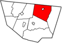
Laporte Township is a township in Sullivan County, Pennsylvania, United States. The population was 404 at the 2020 census. Note that Laporte Township surrounds the borough of Laporte.

<span class="mw-page-title-main">Shrewsbury Township, Sullivan County, Pennsylvania</span> Township in Pennsylvania, United States

Shrewsbury Township is a township in Sullivan County, Pennsylvania, United States. The population was 303 at the 2020 census.

<span class="mw-page-title-main">Little Loyalsock Creek</span>

Little Loyalsock Creek is the major tributary of Loyalsock Creek in Lycoming and Sullivan counties, Pennsylvania, United States. The creek is 19.3 miles (31.1 km) long. Via Loyalsock Creek and the West Branch Susquehanna River, it is part of the Susquehanna River drainage basin, and waters from it flow ultimately into the Chesapeake Bay.

<span class="mw-page-title-main">Pennsylvania Route 87</span> State highway in Pennsylvania, US

Pennsylvania Route 87 is a 69.3-mile-long (111.5 km) north–south state highway located in northern Pennsylvania. The southern terminus of the route is at exit 21 of Interstate 180 (I-180)/U.S. Route 220 in Montoursville. The northern terminus is at US 6 in Washington Township.

<span class="mw-page-title-main">Pennsylvania Route 154</span> State highway in Pennsylvania, US

Pennsylvania Route 154 (PA 154) is a 31.5-mile-long (50.7 km) northwest-southeast state highway located in northern Pennsylvania. The southern terminus is at U.S. Route 220 in Laporte. The northern terminus of the route is at PA 414 in Canton.

<span class="mw-page-title-main">Plunketts Creek (Loyalsock Creek tributary)</span> River in the US state of Pennsylvania

Plunketts Creek is an approximately 6.2-mile-long (10 km) tributary of Loyalsock Creek in Lycoming and Sullivan counties in the U.S. state of Pennsylvania. Two unincorporated villages and a hamlet are on the creek, and its watershed drains 23.6 square miles (61 km2) in parts of five townships. The creek is a part of the Chesapeake Bay drainage basin via Loyalsock Creek and the West Branch Susquehanna and Susquehanna Rivers.

<span class="mw-page-title-main">Sonestown Covered Bridge</span> Covered bridge in Davidson Township, Sullivan County, Pennsylvania

The Sonestown Covered Bridge is a covered bridge over Muncy Creek in Davidson Township, Sullivan County, Pennsylvania built around 1850. It is 110 ft (34 m) long and was placed on the National Register of Historic Places (NRHP) in 1980. It is named for the nearby unincorporated village of Sonestown in Davidson Township, and is also known as the Davidson Covered Bridge. It was built to provide access to a grist mill which operated until the early 20th century.

<span class="mw-page-title-main">Forksville Covered Bridge</span> Bridge over Loyalsock Creek, Pennsylvania

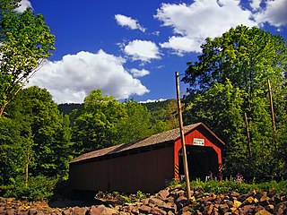
The Forksville Covered Bridge is a Burr arch truss covered bridge over Loyalsock Creek in the borough of Forksville, Sullivan County, in the U.S. state of Pennsylvania. It was built in 1850 and is 152 feet 11 inches (46.61 m) in length. The bridge was placed on the National Register of Historic Places in 1980. The Forksville bridge is named for the borough it is in, which in turn is named for its location at the confluence or "forks" of the Little Loyalsock and Loyalsock Creeks.

<span class="mw-page-title-main">Hillsgrove Covered Bridge</span> Bridge over Loyalsock Creek in Hillsgrove Township, Sullivan County, Pennsylvania

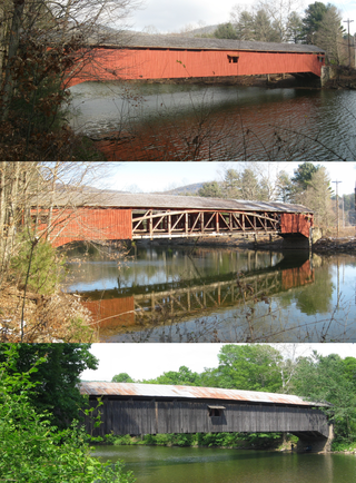
The Hillsgrove Covered Bridge is a Burr arch truss covered bridge over Loyalsock Creek in Hillsgrove Township, Sullivan County, in the U.S. state of Pennsylvania. It was built c. 1850 and is 186 feet (56.7 m) long. In 1973, it became the first covered bridge in the county to be placed on the National Register of Historic Places (NRHP). The bridge is named for the township and nearby unincorporated village of Hillsgrove, and is also known as Rinkers Covered Bridge for an adjoining farm.

References

Unless otherwise noted, all information on area and population comes from the U.S. Census Bureau.

  1. 1 2 3 "U.S. Census website". United States Census Bureau. Retrieved 2012-06-15.
  2. 1 2 3 Trostle, Sharon, ed. (2011). "Chapter 6: Pennsylvania Local Government" (PDF). The Pennsylvania Manual. Commonwealth of Pennsylvania. pp. 6–9, 6–40. Archived from the original (PDF) on 2014-01-16. Retrieved 2012-06-15.
  3. 1 2 Williams, Oliver P. (2001). County Courthouses of Pennsylvania: A Guide. Stackpole Books. pp. 193–195. ISBN   0-8117-2738-6 . Retrieved 2012-06-15.
  4. Michels, Chris (1997). "Latitude/Longitude Distance Calculation". Northern Arizona University. Retrieved 2012-06-15.
  5. 1 2 3 Meginness, John Franklin (1892). History of Lycoming County, Pennsylvania: including its aboriginal history; the colonial and revolutionary periods; early settlement and subsequent growth; organization and civil administration; the legal and medical professions; internal improvement; past and present history of Williamsport; manufacturing and lumber interests; religious, educational, and social development; geology and agriculture; military record; sketches of boroughs, townships, and villages; portraits and biographies of pioneers and representative citizens, etc. etc (1st ed.). Chicago, IL: brown, Runk & Co. ISBN   0-7884-0428-8 . Retrieved 2012-06-15. (Note: ISBN refers to Heritage Books July 1996 reprint. URL is to a scan of the 1892 version with some OCR typos).
  6. 1 2 3 4 5 6 7 8 9 10 11 Godcharles, Frederic A. (1933). Pennsylvania: Political, Governmental, Military and Civil: Political and Civil History Volume (First ed.). New York, New York: The American Historical Society.
  7. 1 2 3 4 5 6 7 8 9 10 11 12 Thomas J. Ingham (1899). History of Sullivan County, Pennsylvania: Compendium of Biography. Chicago, Illinois: Lewis Publishing Co. OCLC   35904783 . Retrieved 2012-06-15.
  8. "Historical Census Browser: Pennsylvania: Pennsylvania: Total Population by County 1850-1960". University of Virginia Library. Archived from the original (Searchable database) on 2007-07-15. Retrieved 2012-06-15.
  9. Richard L. Forstall (March 27, 1995). "Pennsylvania, Population of Counties by Decennial Census: 1900 to 1990". U.S. Census Bureau . Retrieved 2012-06-15.
  10. 1 2 3 4 5 6 7 8 9 10 11 12 13 14 15 16 17 "Sullivan County 7th class" (PDF). Pennsylvania Historical and Museum Commission. Retrieved 2012-06-15.
  11. 1 2 3 "Lycoming County 5th class" (PDF). Pennsylvania Historical and Museum Commission . Retrieved 2012-06-15.