Davidson Township, Sullivan County, Pennsylvania

Last updated

Davidson Township, Pennsylvania
Davidson Township Covered Bridge.jpg
Sonestown Covered Bridge in Davidson Township
Map of Sullivan County Pennsylvania Highlighting Davidson Township.png
Map of Sullivan County, Pennsylvania highlighting Davidson Township
Map of Pennsylvania highlighting Sullivan County.svg
Map of Pennsylvania highlighting Sullivan County
Coordinates: 41°20′00″N76°26′59″W / 41.33333°N 76.44972°W / 41.33333; -76.44972
Country United States
State Pennsylvania
County Sullivan
Settled1806
Incorporated1833
Area
[1]
  Total77.92 sq mi (201.82 km2)
  Land77.86 sq mi (201.66 km2)
  Water0.06 sq mi (0.15 km2)
Elevation
2,385 ft (727 m)
Population
 (2020) [2]
  Total544 Decrease2.svg
  Estimate 
(2021) [2]
547
  Density6.92/sq mi (2.67/km2)
Time zone Eastern (EST)
  Summer (DST)EDT
FIPS code 42-113-18296

Davidson Township is a township in Sullivan County, Pennsylvania, United States. The population was 544 at the 2020 census. [2]

Contents

History

The Sonestown Covered Bridge was added to the National Register of Historic Places in 1980. [3]

Geography

Big Run falls in Davidson Township Big Run falls 1.JPG
Big Run falls in Davidson Township
Jamison City Road in Davidson Township Jamison City Road.JPG
Jamison City Road in Davidson Township

According to the United States Census Bureau, the township has a total area of 78.2 square miles (203 km2), of which 78.1 square miles (202 km2) is land and 0.1 square miles (0.26 km2) (0.08%) is water.

Davidson Township is bordered by Laporte Township to the north, Colley Township and Luzerne County to the east and Columbia and Lycoming Counties to the south and Shrewsbury Township to the west.

Demographics

Historical population
CensusPop.Note
2010 573
2020 544−5.1%
2021 (est.)547 [2] 0.6%
U.S. Decennial Census [4]

As of the census [5] of 2000, there were 626 people, 269 households, and 189 families residing in the township. The population density was 8.0 people per square mile (3.1/km2). There were 602 housing units at an average density of 7.7/sq mi (3.0/km2). The racial makeup of the township was 98.40% White, 0.16% African American, 0.32% Native American, 0.16% from other races, and 0.96% from two or more races. Hispanic or Latino of any race were 0.48% of the population.

There were 269 households, out of which 25.3% had children under the age of 18 living with them, 59.1% were married couples living together, 8.2% had a female householder with no husband present, and 29.4% were non-families. 26.8% of all households were made up of individuals, and 13.8% had someone living alone who was 65 years of age or older. The average household size was 2.33 and the average family size was 2.76.

In the township the population was spread out, with 18.4% under the age of 18, 8.1% from 18 to 24, 26.2% from 25 to 44, 27.8% from 45 to 64, and 19.5% who were 65 years of age or older. The median age was 43 years. For every 100 females, there were 102.6 males. For every 100 females age 18 and over, there were 98.8 males.

The median income for a household in the township was $32,857, and the median income for a family was $36,875. Males had a median income of $24,875 versus $22,054 for females. The per capita income for the township was $14,483. About 3.0% of families and 7.3% of the population were below the poverty line, including 4.2% of those under age 18 and 2.4% of those age 65 or over.

Muncy Creek Valley in Davidson Township Muncy Creek Valley Panorama.JPG
Muncy Creek Valley in Davidson Township

Notable person

American Idol season 9 Star, Aaron Kelly

Related Research Articles

Fox Lake Hills is an unincorporated community and census-designated place (CDP) in Lake Villa Township, Lake County, Illinois, United States. Per the 2020 census, the population was 2,684.

<span class="mw-page-title-main">Stanton, Michigan</span> City in Michigan, United States

Stanton is a city in the U.S. state of Michigan. The population was 1,348 at the 2020 census. It is the county seat of Montcalm County.

Moe Township is a township in Douglas County, Minnesota, United States. The population was 683 at the 2000 census.

Petersburg Township is a township in Jackson County, Minnesota, United States. The population was 269 at the 2000 census.

Comfort Township is a township in Kanabec County, Minnesota, United States. The population was 931 at the 2000 census.

Arctander Township is a township in Kandiyohi County, Minnesota, United States. The population was 401 at the 2000 census.

Burbank Township is a township in Kandiyohi County, Minnesota, United States. The population was 510 at the 2000 census.

Colfax Township is a township in Kandiyohi County, Minnesota, United States. The population was 557 at the 2000 census.

Dovre Township is a township in Kandiyohi County, Minnesota, United States. The population was 1,968 at the 2000 census.

East Lake Lillian Township is a township in Kandiyohi County, Minnesota, United States. The population was 225 at the 2000 census.

Edwards Township is a township in Kandiyohi County, Minnesota, United States. The population was 304 at the 2000 census.

Fahlun Township is a township in Kandiyohi County, Minnesota, United States. The population was 412 at the 2000 census.

Center Creek Township is a township in Martin County, Minnesota, United States. The population was 269 at the 2000 census.

Jay Township is a township in Martin County, Minnesota, United States. The population was 269 at the 2000 census.

Bird Island Township is a township in Renville County, Minnesota, United States. The population was 269 at the 2000 census.

<span class="mw-page-title-main">Berlin Heights, Ohio</span> Village in Ohio, United States

Berlin Heights is a village in Berlin Township, Erie County, Ohio, United States. The population was 651 at the 2020 census. It is part of the Sandusky, Ohio Metropolitan Statistical Area.

<span class="mw-page-title-main">Marlin, Pennsylvania</span> CDP in Pennsylvania, United States

Marlin, or MarLin is a census-designated place (CDP) in Schuylkill County, Pennsylvania, United States. The population was 640 at the 2000 census. It is a village of Norwegian Township. The village is the seat of government for the township.

<span class="mw-page-title-main">Colley Township, Sullivan County, Pennsylvania</span> Township in Pennsylvania, United States

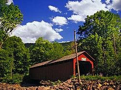
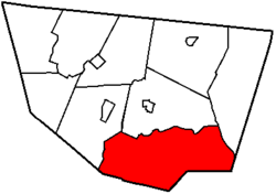
Colley Township is a township in Sullivan County, Pennsylvania, United States. The population was 626 at the 2020 census. The village of Lopez is located in the township.

<span class="mw-page-title-main">Laporte Township, Sullivan County, Pennsylvania</span> Township in Pennsylvania, United States

Laporte Township is a township in Sullivan County, Pennsylvania, United States. The population was 404 at the 2020 census. Note that Laporte Township surrounds the borough of Laporte.

<span class="mw-page-title-main">Franklin Township, Susquehanna County, Pennsylvania</span> Township in Pennsylvania, United States

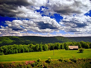
Franklin Township is a township in Susquehanna County, Pennsylvania, United States. The population was 833 at the 2020 census. Salt Springs State Park, a Pennsylvania state park, is in Franklin Township.

References

  1. "2016 U.S. Gazetteer Files". United States Census Bureau. Retrieved August 14, 2017.
  2. 1 2 3 4 Bureau, US Census. "City and Town Population Totals: 2020—2021". Census.gov. US Census Bureau. Retrieved August 6, 2022.
  3. "National Register Information System". National Register of Historic Places . National Park Service. July 9, 2010.
  4. "Census of Population and Housing". Census.gov. Retrieved June 4, 2016.
  5. "U.S. Census website". United States Census Bureau . Retrieved January 31, 2008.